


Jakub Nowosad
@nowosad.fosstodon.org.ap.brid.gy
Computational geographer. Associate Professor at AMU, Poznan, Poland. Co-author of http://r.geocompx.org, http://py.geocompx.org, and http://r-tmap.github.io […]
[bridged from https://fosstodon.org/@nowosad on the fediverse by https://fed.brid.gy/ ]
[bridged from https://fosstodon.org/@nowosad on the fediverse by https://fed.brid.gy/ ]
Confused about coordinate reference systems (CRSs)? 🧭🌍🐍
Chapter 6 of Geocomputation with Python dives into:
- Geographic vs projected CRSs (lon/lat vs meters)
- Getting, setting & reprojecting CRSs
- Why ignoring CRSs can break your analysis 🚨
👉 […]
[Original post on fosstodon.org]
Chapter 6 of Geocomputation with Python dives into:
- Geographic vs projected CRSs (lon/lat vs meters)
- Getting, setting & reprojecting CRSs
- Why ignoring CRSs can break your analysis 🚨
👉 […]
[Original post on fosstodon.org]
November 9, 2025 at 2:02 PM
Confused about coordinate reference systems (CRSs)? 🧭🌍🐍
Chapter 6 of Geocomputation with Python dives into:
- Geographic vs projected CRSs (lon/lat vs meters)
- Getting, setting & reprojecting CRSs
- Why ignoring CRSs can break your analysis 🚨
👉 […]
[Original post on fosstodon.org]
Chapter 6 of Geocomputation with Python dives into:
- Geographic vs projected CRSs (lon/lat vs meters)
- Getting, setting & reprojecting CRSs
- Why ignoring CRSs can break your analysis 🚨
👉 […]
[Original post on fosstodon.org]
The CRAN Spatial Task View just got a proper table of contents (thanks to Krzysztof Dyba) -- easier to navigate all those R spatial packages now. 🌍
> https://cran.r-project.org/view=Spatial
#rstats #rspatial #opensource #gischat
> https://cran.r-project.org/view=Spatial
#rstats #rspatial #opensource #gischat


November 5, 2025 at 2:02 PM
The CRAN Spatial Task View just got a proper table of contents (thanks to Krzysztof Dyba) -- easier to navigate all those R spatial packages now. 🌍
> https://cran.r-project.org/view=Spatial
#rstats #rspatial #opensource #gischat
> https://cran.r-project.org/view=Spatial
#rstats #rspatial #opensource #gischat
🌍 Blog series: Spatial Machine Learning with R
From caret to tidymodels, mlr3, and specialized spatial ML packages — explore how spatial context changes the way we build ML models in R.
Start with Part 1 👉 https://geocompx.org/post/2025/sml-bp1/
#rstats #spatialml #machinelearning #rspatial
From caret to tidymodels, mlr3, and specialized spatial ML packages — explore how spatial context changes the way we build ML models in R.
Start with Part 1 👉 https://geocompx.org/post/2025/sml-bp1/
#rstats #spatialml #machinelearning #rspatial


October 22, 2025 at 1:02 PM
🌍 Blog series: Spatial Machine Learning with R
From caret to tidymodels, mlr3, and specialized spatial ML packages — explore how spatial context changes the way we build ML models in R.
Start with Part 1 👉 https://geocompx.org/post/2025/sml-bp1/
#rstats #spatialml #machinelearning #rspatial
From caret to tidymodels, mlr3, and specialized spatial ML packages — explore how spatial context changes the way we build ML models in R.
Start with Part 1 👉 https://geocompx.org/post/2025/sml-bp1/
#rstats #spatialml #machinelearning #rspatial

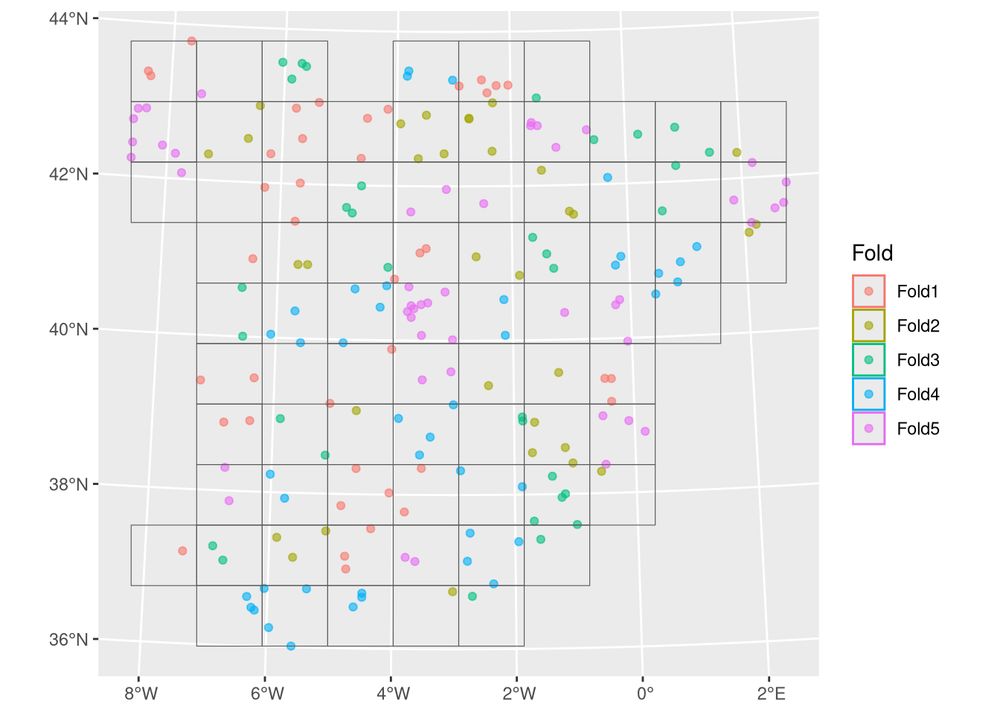
New R package: gridmappr by Roger Beecham
It automates creating small multiple gridmap layouts by optimally placing geographic points into grid cells (inspired by Jo Wood’s Observable notebooks).
👉 https://github.com/rogerbeecham/gridmappr
#rstats #rspatial #dataviz #gischat
It automates creating small multiple gridmap layouts by optimally placing geographic points into grid cells (inspired by Jo Wood’s Observable notebooks).
👉 https://github.com/rogerbeecham/gridmappr
#rstats #rspatial #dataviz #gischat

October 15, 2025 at 1:02 PM
New R package: gridmappr by Roger Beecham
It automates creating small multiple gridmap layouts by optimally placing geographic points into grid cells (inspired by Jo Wood’s Observable notebooks).
👉 https://github.com/rogerbeecham/gridmappr
#rstats #rspatial #dataviz #gischat
It automates creating small multiple gridmap layouts by optimally placing geographic points into grid cells (inspired by Jo Wood’s Observable notebooks).
👉 https://github.com/rogerbeecham/gridmappr
#rstats #rspatial #dataviz #gischat

Working with geospatial attribute data in Python? 📊🌍🐍
Chapter 2 of Geocomputation with Python covers subsetting, aggregation & joins for vector data, and subsetting + summarizing raster values.
👉 https://py.geocompx.org/02-attribute-operations
#geopython #python #gischat
Chapter 2 of Geocomputation with Python covers subsetting, aggregation & joins for vector data, and subsetting + summarizing raster values.
👉 https://py.geocompx.org/02-attribute-operations
#geopython #python #gischat


October 12, 2025 at 1:02 PM
Working with geospatial attribute data in Python? 📊🌍🐍
Chapter 2 of Geocomputation with Python covers subsetting, aggregation & joins for vector data, and subsetting + summarizing raster values.
👉 https://py.geocompx.org/02-attribute-operations
#geopython #python #gischat
Chapter 2 of Geocomputation with Python covers subsetting, aggregation & joins for vector data, and subsetting + summarizing raster values.
👉 https://py.geocompx.org/02-attribute-operations
#geopython #python #gischat
New blog post by Adam Steer: Identifying deformed sea ice using geomorphons ❄️🌊
Exploring sea ice as a landscape analysis problem with QGIS + GRASS GIS, using drone + lidar data.
👉 https://www.spatialised.net/identifying-deformed-sea-ice-using-geomorphons/
#geospatial #rstats #rspatial #gischat
Exploring sea ice as a landscape analysis problem with QGIS + GRASS GIS, using drone + lidar data.
👉 https://www.spatialised.net/identifying-deformed-sea-ice-using-geomorphons/
#geospatial #rstats #rspatial #gischat


October 8, 2025 at 1:02 PM
New blog post by Adam Steer: Identifying deformed sea ice using geomorphons ❄️🌊
Exploring sea ice as a landscape analysis problem with QGIS + GRASS GIS, using drone + lidar data.
👉 https://www.spatialised.net/identifying-deformed-sea-ice-using-geomorphons/
#geospatial #rstats #rspatial #gischat
Exploring sea ice as a landscape analysis problem with QGIS + GRASS GIS, using drone + lidar data.
👉 https://www.spatialised.net/identifying-deformed-sea-ice-using-geomorphons/
#geospatial #rstats #rspatial #gischat
Starting out with geographic data in Python? 🌍🐍
Chapter 1 of Geocomputation with Python introduces vector & raster models + core tools (geopandas, shapely, rasterio).
👉 https://py.geocompx.org/01-spatial-data
#geopython #python #gischat
Chapter 1 of Geocomputation with Python introduces vector & raster models + core tools (geopandas, shapely, rasterio).
👉 https://py.geocompx.org/01-spatial-data
#geopython #python #gischat


October 5, 2025 at 1:01 PM
Starting out with geographic data in Python? 🌍🐍
Chapter 1 of Geocomputation with Python introduces vector & raster models + core tools (geopandas, shapely, rasterio).
👉 https://py.geocompx.org/01-spatial-data
#geopython #python #gischat
Chapter 1 of Geocomputation with Python introduces vector & raster models + core tools (geopandas, shapely, rasterio).
👉 https://py.geocompx.org/01-spatial-data
#geopython #python #gischat
New post by David O’Sullivan:
“Raster really is faster (and vaster), but vector just seems more corrector.”
Part 1A of a series revisiting ideas from Geographic Information Analysis: fractals, raster vs vector, and R code.
👉 […]
[Original post on fosstodon.org]
“Raster really is faster (and vaster), but vector just seems more corrector.”
Part 1A of a series revisiting ideas from Geographic Information Analysis: fractals, raster vs vector, and R code.
👉 […]
[Original post on fosstodon.org]


October 1, 2025 at 1:01 PM
New post by David O’Sullivan:
“Raster really is faster (and vaster), but vector just seems more corrector.”
Part 1A of a series revisiting ideas from Geographic Information Analysis: fractals, raster vs vector, and R code.
👉 […]
[Original post on fosstodon.org]
“Raster really is faster (and vaster), but vector just seems more corrector.”
Part 1A of a series revisiting ideas from Geographic Information Analysis: fractals, raster vs vector, and R code.
👉 […]
[Original post on fosstodon.org]
🌍Exploring Sentinel-2 with the Copernicus Data Space Ecosystem (CDSE)?
Hugh Graham’s guide with vrtility in #rstats. Includes authentication & query of imagery and building cloud-free composites […]
[Original post on fosstodon.org]
Hugh Graham’s guide with vrtility in #rstats. Includes authentication & query of imagery and building cloud-free composites […]
[Original post on fosstodon.org]

September 24, 2025 at 1:22 PM
🌍Exploring Sentinel-2 with the Copernicus Data Space Ecosystem (CDSE)?
Hugh Graham’s guide with vrtility in #rstats. Includes authentication & query of imagery and building cloud-free composites […]
[Original post on fosstodon.org]
Hugh Graham’s guide with vrtility in #rstats. Includes authentication & query of imagery and building cloud-free composites […]
[Original post on fosstodon.org]
This week (Sep 15–19) I’m attending the #ecmlpkdd2025 conf in Porto!
Happy to chat about the intersection of machine learning and spatial data -- reach out if you’d like to meet. 🌍
#ECMLPKDD2025 #machinelearning #geospatial
Happy to chat about the intersection of machine learning and spatial data -- reach out if you’d like to meet. 🌍
#ECMLPKDD2025 #machinelearning #geospatial

September 15, 2025 at 1:03 PM
This week (Sep 15–19) I’m attending the #ecmlpkdd2025 conf in Porto!
Happy to chat about the intersection of machine learning and spatial data -- reach out if you’d like to meet. 🌍
#ECMLPKDD2025 #machinelearning #geospatial
Happy to chat about the intersection of machine learning and spatial data -- reach out if you’d like to meet. 🌍
#ECMLPKDD2025 #machinelearning #geospatial
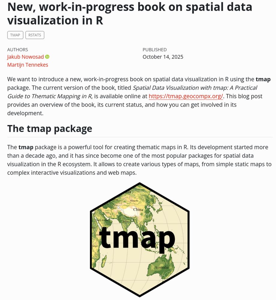
🚀 Book in progress: Spatial Data Visualization with tmap
A practical guide to creating clear thematic maps in R with the tmap package.
Covers everything from loading data to interactive and animated maps, with reproducible code and examples.
Read online […]
[Original post on fosstodon.org]
A practical guide to creating clear thematic maps in R with the tmap package.
Covers everything from loading data to interactive and animated maps, with reproducible code and examples.
Read online […]
[Original post on fosstodon.org]


September 14, 2025 at 1:00 PM
🚀 Book in progress: Spatial Data Visualization with tmap
A practical guide to creating clear thematic maps in R with the tmap package.
Covers everything from loading data to interactive and animated maps, with reproducible code and examples.
Read online […]
[Original post on fosstodon.org]
A practical guide to creating clear thematic maps in R with the tmap package.
Covers everything from loading data to interactive and animated maps, with reproducible code and examples.
Read online […]
[Original post on fosstodon.org]
📢 Materials from the OpenGeoHub Summer School 2025 (“Data Science for Earth Observation”) by Krzysztof Dyba are now online.
Discuss how to access, process, and analyze satellite data with #rstats.
👉 https://github.com/kadyb/OGH2025
#rspatial #remotesensing #gischat
Discuss how to access, process, and analyze satellite data with #rstats.
👉 https://github.com/kadyb/OGH2025
#rspatial #remotesensing #gischat


September 10, 2025 at 2:01 PM
📢 Materials from the OpenGeoHub Summer School 2025 (“Data Science for Earth Observation”) by Krzysztof Dyba are now online.
Discuss how to access, process, and analyze satellite data with #rstats.
👉 https://github.com/kadyb/OGH2025
#rspatial #remotesensing #gischat
Discuss how to access, process, and analyze satellite data with #rstats.
👉 https://github.com/kadyb/OGH2025
#rspatial #remotesensing #gischat
🌍 Call for Papers! Submit to the Progress in Physical Geography special issue:
Coding Earth: Open Source Solutions in Physical Geography
📅 Deadline: 18 Dec 2025
🔗 journals.sagepub.com/home/ppg
#opensource #openscience #gischat #rspatial #geopython
Coding Earth: Open Source Solutions in Physical Geography
📅 Deadline: 18 Dec 2025
🔗 journals.sagepub.com/home/ppg
#opensource #openscience #gischat #rspatial #geopython

September 7, 2025 at 2:01 PM
🌍 Call for Papers! Submit to the Progress in Physical Geography special issue:
Coding Earth: Open Source Solutions in Physical Geography
📅 Deadline: 18 Dec 2025
🔗 journals.sagepub.com/home/ppg
#opensource #openscience #gischat #rspatial #geopython
Coding Earth: Open Source Solutions in Physical Geography
📅 Deadline: 18 Dec 2025
🔗 journals.sagepub.com/home/ppg
#opensource #openscience #gischat #rspatial #geopython
We’ve updated the geocompx README.
Find guides, books, and tools for geocomputation in R, Python, and Julia — plus ways to get involved.
Take a look: https://github.com/geocompx
#geocomputation #rstats #python #opensource #geocompx
Find guides, books, and tools for geocomputation in R, Python, and Julia — plus ways to get involved.
Take a look: https://github.com/geocompx
#geocomputation #rstats #python #opensource #geocompx

September 1, 2025 at 2:03 PM
We’ve updated the geocompx README.
Find guides, books, and tools for geocomputation in R, Python, and Julia — plus ways to get involved.
Take a look: https://github.com/geocompx
#geocomputation #rstats #python #opensource #geocompx
Find guides, books, and tools for geocomputation in R, Python, and Julia — plus ways to get involved.
Take a look: https://github.com/geocompx
#geocomputation #rstats #python #opensource #geocompx
📦 New R package: sfhotspot by Matt Ashby
Identify & analyze spatial clusters of points (places/events) entirely with sf objects.
Includes tools for counts, change over time, kernel density, Getis–Ord Gi*, & classification.
🔗 GitHub […]
[Original post on fosstodon.org]
Identify & analyze spatial clusters of points (places/events) entirely with sf objects.
Includes tools for counts, change over time, kernel density, Getis–Ord Gi*, & classification.
🔗 GitHub […]
[Original post on fosstodon.org]


August 27, 2025 at 2:01 PM
📦 New R package: sfhotspot by Matt Ashby
Identify & analyze spatial clusters of points (places/events) entirely with sf objects.
Includes tools for counts, change over time, kernel density, Getis–Ord Gi*, & classification.
🔗 GitHub […]
[Original post on fosstodon.org]
Identify & analyze spatial clusters of points (places/events) entirely with sf objects.
Includes tools for counts, change over time, kernel density, Getis–Ord Gi*, & classification.
🔗 GitHub […]
[Original post on fosstodon.org]
🌍 Which geospatial conferences are you excited about in 2026?
I'm compiling a list at https://github.com/Nowosad/conferences_2026 -- please contribute events you know about!
What am I missing?
#gis #remotesensing #spatialdata #gischat
I'm compiling a list at https://github.com/Nowosad/conferences_2026 -- please contribute events you know about!
What am I missing?
#gis #remotesensing #spatialdata #gischat

August 20, 2025 at 2:02 PM
🌍 Which geospatial conferences are you excited about in 2026?
I'm compiling a list at https://github.com/Nowosad/conferences_2026 -- please contribute events you know about!
What am I missing?
#gis #remotesensing #spatialdata #gischat
I'm compiling a list at https://github.com/Nowosad/conferences_2026 -- please contribute events you know about!
What am I missing?
#gis #remotesensing #spatialdata #gischat
Chapter 16: Summary & Future of Geocomputation 🚀📖
What’s next? 📌 This final chapter reflects on key themes, gaps, and the future of geocomputation. Crucially, learn how to contribute to open-source spatial communities!
🔗 https://r.geocompx.org/conclusion
#rstats #rspatial #geocompx
What’s next? 📌 This final chapter reflects on key themes, gaps, and the future of geocomputation. Crucially, learn how to contribute to open-source spatial communities!
🔗 https://r.geocompx.org/conclusion
#rstats #rspatial #geocompx

August 10, 2025 at 4:01 PM
Chapter 16: Summary & Future of Geocomputation 🚀📖
What’s next? 📌 This final chapter reflects on key themes, gaps, and the future of geocomputation. Crucially, learn how to contribute to open-source spatial communities!
🔗 https://r.geocompx.org/conclusion
#rstats #rspatial #geocompx
What’s next? 📌 This final chapter reflects on key themes, gaps, and the future of geocomputation. Crucially, learn how to contribute to open-source spatial communities!
🔗 https://r.geocompx.org/conclusion
#rstats #rspatial #geocompx
Check out "Scaling the r-spatial ecosystem" by Dewey Dunnington 🌍📦
An exploration of how R’s spatial tools can be used for big(ger) data.
Video: https://youtu.be/tjNEoIYr_ag?feature=shared
Slides: https://dewey.dunnington.ca/slides/rspatial2025
#rstats #rspatial #gis #spatialdata
An exploration of how R’s spatial tools can be used for big(ger) data.
Video: https://youtu.be/tjNEoIYr_ag?feature=shared
Slides: https://dewey.dunnington.ca/slides/rspatial2025
#rstats #rspatial #gis #spatialdata


August 6, 2025 at 2:03 PM
Check out "Scaling the r-spatial ecosystem" by Dewey Dunnington 🌍📦
An exploration of how R’s spatial tools can be used for big(ger) data.
Video: https://youtu.be/tjNEoIYr_ag?feature=shared
Slides: https://dewey.dunnington.ca/slides/rspatial2025
#rstats #rspatial #gis #spatialdata
An exploration of how R’s spatial tools can be used for big(ger) data.
Video: https://youtu.be/tjNEoIYr_ag?feature=shared
Slides: https://dewey.dunnington.ca/slides/rspatial2025
#rstats #rspatial #gis #spatialdata
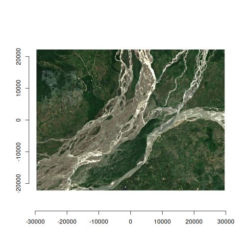
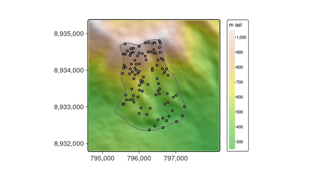
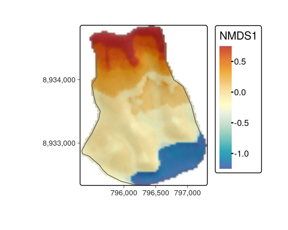
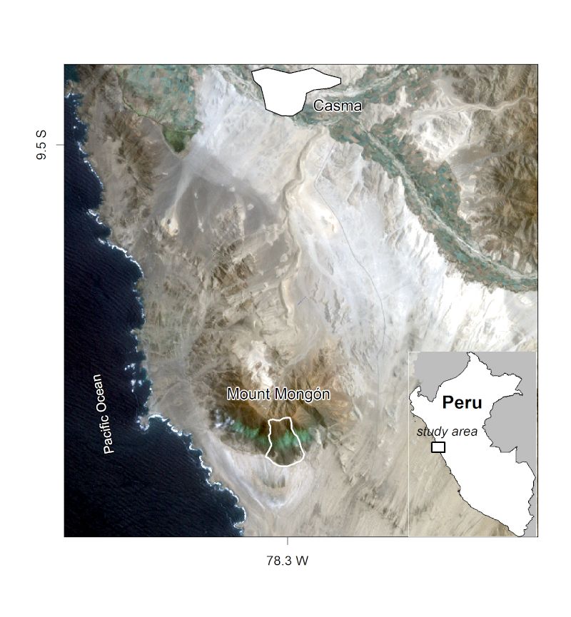
Chapter 15: Ecological Modeling & Geocomputation 🌱🗺️
Modeling the floristic gradient to reveal distinctive vegetation belts! 📌 Learn spatial modeling techniques with random forests & hyperparameter tuning to analyze ecological data in R.
🔗 https://r.geocompx.org/eco
#rstats #rspatial #geocompx
Modeling the floristic gradient to reveal distinctive vegetation belts! 📌 Learn spatial modeling techniques with random forests & hyperparameter tuning to analyze ecological data in R.
🔗 https://r.geocompx.org/eco
#rstats #rspatial #geocompx
August 3, 2025 at 4:01 PM
Chapter 15: Ecological Modeling & Geocomputation 🌱🗺️
Modeling the floristic gradient to reveal distinctive vegetation belts! 📌 Learn spatial modeling techniques with random forests & hyperparameter tuning to analyze ecological data in R.
🔗 https://r.geocompx.org/eco
#rstats #rspatial #geocompx
Modeling the floristic gradient to reveal distinctive vegetation belts! 📌 Learn spatial modeling techniques with random forests & hyperparameter tuning to analyze ecological data in R.
🔗 https://r.geocompx.org/eco
#rstats #rspatial #geocompx
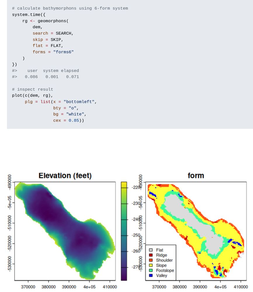
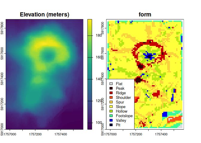
New R package: rgeomorphon 📦 by Andrew Brown
Classifies terrain forms using a parallel C++ implementation of the geomorphon algorithm.
🔗 https://github.com/brownag/rgeomorphon
#rstats #gis #terrainanalysis #remotesensing #rspatial
Classifies terrain forms using a parallel C++ implementation of the geomorphon algorithm.
🔗 https://github.com/brownag/rgeomorphon
#rstats #gis #terrainanalysis #remotesensing #rspatial
July 30, 2025 at 2:01 PM
New R package: rgeomorphon 📦 by Andrew Brown
Classifies terrain forms using a parallel C++ implementation of the geomorphon algorithm.
🔗 https://github.com/brownag/rgeomorphon
#rstats #gis #terrainanalysis #remotesensing #rspatial
Classifies terrain forms using a parallel C++ implementation of the geomorphon algorithm.
🔗 https://github.com/brownag/rgeomorphon
#rstats #gis #terrainanalysis #remotesensing #rspatial
Chapter 14: Geomarketing & Location Analysis 🏪📍
Where should you open a bike shop? 📌 Learn how to use census & OpenStreetMap data for spatial decision-making in geomarketing & site selection.
🔗 https://r.geocompx.org/location
#rstats #rspatial #geocompx
Where should you open a bike shop? 📌 Learn how to use census & OpenStreetMap data for spatial decision-making in geomarketing & site selection.
🔗 https://r.geocompx.org/location
#rstats #rspatial #geocompx


July 27, 2025 at 3:07 PM
Chapter 14: Geomarketing & Location Analysis 🏪📍
Where should you open a bike shop? 📌 Learn how to use census & OpenStreetMap data for spatial decision-making in geomarketing & site selection.
🔗 https://r.geocompx.org/location
#rstats #rspatial #geocompx
Where should you open a bike shop? 📌 Learn how to use census & OpenStreetMap data for spatial decision-making in geomarketing & site selection.
🔗 https://r.geocompx.org/location
#rstats #rspatial #geocompx
Have you read Geocomputation with R?📘
If you found it helpful, we’d really appreciate a quick review — it helps others find the book too!
Goodreads: https://www.goodreads.com/book/show/214736719-geocomputation-with-r
Amazon […]
[Original post on fosstodon.org]
If you found it helpful, we’d really appreciate a quick review — it helps others find the book too!
Goodreads: https://www.goodreads.com/book/show/214736719-geocomputation-with-r
Amazon […]
[Original post on fosstodon.org]
July 23, 2025 at 4:03 PM
Have you read Geocomputation with R?📘
If you found it helpful, we’d really appreciate a quick review — it helps others find the book too!
Goodreads: https://www.goodreads.com/book/show/214736719-geocomputation-with-r
Amazon […]
[Original post on fosstodon.org]
If you found it helpful, we’d really appreciate a quick review — it helps others find the book too!
Goodreads: https://www.goodreads.com/book/show/214736719-geocomputation-with-r
Amazon […]
[Original post on fosstodon.org]
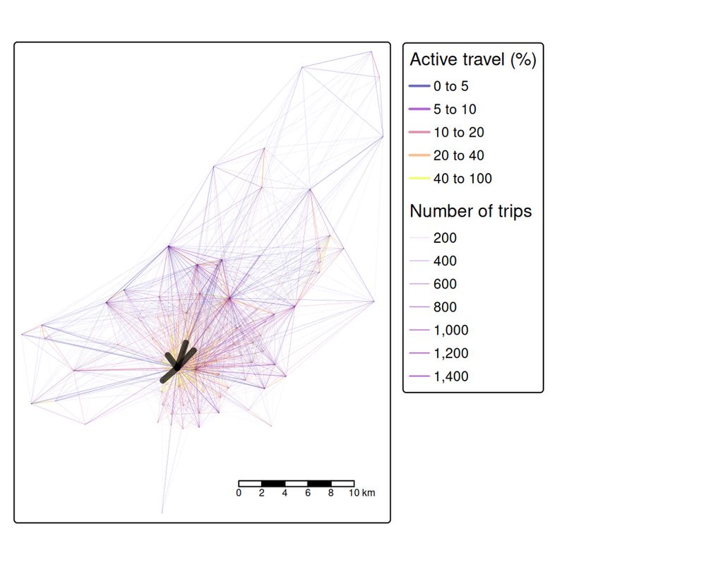
Chapter 13: Transport Systems Analysis 🚶🚴🚌
Model transport networks! 📌 Analyze travel patterns, desire lines, routes, and accessibility using open data and reproducible geospatial workflows in R.
🔗 https://r.geocompx.org/transport
#rstats #rspatial #geocompx
Model transport networks! 📌 Analyze travel patterns, desire lines, routes, and accessibility using open data and reproducible geospatial workflows in R.
🔗 https://r.geocompx.org/transport
#rstats #rspatial #geocompx


July 20, 2025 at 4:03 PM
Chapter 13: Transport Systems Analysis 🚶🚴🚌
Model transport networks! 📌 Analyze travel patterns, desire lines, routes, and accessibility using open data and reproducible geospatial workflows in R.
🔗 https://r.geocompx.org/transport
#rstats #rspatial #geocompx
Model transport networks! 📌 Analyze travel patterns, desire lines, routes, and accessibility using open data and reproducible geospatial workflows in R.
🔗 https://r.geocompx.org/transport
#rstats #rspatial #geocompx