


Mount St. Helens in 1980 | #MSH45
@mountsthelens1980.bsky.social
Hi there, I’m Chris—a former SciComms guy talking to you about the 1980 eruption of Mount St. Helens.
About Me: https://bsky.app/profile/mountsthelens1980.bsky.social/post/3lohgbvt4ab2d
Links: https://linktr.ee/sthelensin1980
About Me: https://bsky.app/profile/mountsthelens1980.bsky.social/post/3lohgbvt4ab2d
Links: https://linktr.ee/sthelensin1980
On what would have been his 76th birthday, we remember USGS volcanologist Dr. David A. Johnston.

December 18, 2025 at 5:08 PM
On what would have been his 76th birthday, we remember USGS volcanologist Dr. David A. Johnston.
At 20 miles, it’s “look at that.”
At 14 miles, it’s “it’s coming over the ridge.”
Mike Moore, camping by the Green River near Independence Mine with his family, raised his camera and kept shooting — 12 quick frames — as the cloud rolled in and swallowed the view.
The four Moores would survive.
At 14 miles, it’s “it’s coming over the ridge.”
Mike Moore, camping by the Green River near Independence Mine with his family, raised his camera and kept shooting — 12 quick frames — as the cloud rolled in and swallowed the view.
The four Moores would survive.


December 17, 2025 at 1:56 AM
At 20 miles, it’s “look at that.”
At 14 miles, it’s “it’s coming over the ridge.”
Mike Moore, camping by the Green River near Independence Mine with his family, raised his camera and kept shooting — 12 quick frames — as the cloud rolled in and swallowed the view.
The four Moores would survive.
At 14 miles, it’s “it’s coming over the ridge.”
Mike Moore, camping by the Green River near Independence Mine with his family, raised his camera and kept shooting — 12 quick frames — as the cloud rolled in and swallowed the view.
The four Moores would survive.
For Carolyn Brault, there's an unexpected feeling felt three years later: gratitude.
March 1980: they moved furniture out as St. Helens woke up — then moved it back two days before the eruption. Material losses, yes, but none between family.
"My marriage and family were made stronger by May 18."
March 1980: they moved furniture out as St. Helens woke up — then moved it back two days before the eruption. Material losses, yes, but none between family.
"My marriage and family were made stronger by May 18."


December 16, 2025 at 3:50 AM
For Carolyn Brault, there's an unexpected feeling felt three years later: gratitude.
March 1980: they moved furniture out as St. Helens woke up — then moved it back two days before the eruption. Material losses, yes, but none between family.
"My marriage and family were made stronger by May 18."
March 1980: they moved furniture out as St. Helens woke up — then moved it back two days before the eruption. Material losses, yes, but none between family.
"My marriage and family were made stronger by May 18."
By Dec. '82, Gary publicly expressed frustration in a letter about broken promises and stalled fixes.
"The odds may be against us, but we'll survive." A settlement was reached with Allstate in May 1983.
In January 1984, one final curse hits. The structure, refurbished and rented out, burns down.
"The odds may be against us, but we'll survive." A settlement was reached with Allstate in May 1983.
In January 1984, one final curse hits. The structure, refurbished and rented out, burns down.


December 16, 2025 at 3:50 AM
By Dec. '82, Gary publicly expressed frustration in a letter about broken promises and stalled fixes.
"The odds may be against us, but we'll survive." A settlement was reached with Allstate in May 1983.
In January 1984, one final curse hits. The structure, refurbished and rented out, burns down.
"The odds may be against us, but we'll survive." A settlement was reached with Allstate in May 1983.
In January 1984, one final curse hits. The structure, refurbished and rented out, burns down.
In July, the Small Business Administration issued a local disaster loan to help the Braults replace what they lost and move the house to higher ground... but it comes with catches.
Gary also learns how quickly “lahar” turns into “flood damage” in an insurance file. Battles are fought for years.
Gary also learns how quickly “lahar” turns into “flood damage” in an insurance file. Battles are fought for years.


December 16, 2025 at 3:50 AM
In July, the Small Business Administration issued a local disaster loan to help the Braults replace what they lost and move the house to higher ground... but it comes with catches.
Gary also learns how quickly “lahar” turns into “flood damage” in an insurance file. Battles are fought for years.
Gary also learns how quickly “lahar” turns into “flood damage” in an insurance file. Battles are fought for years.
Before the Braults moved in, it was known as the "Hard Luck House" around the village of Kid Valley. A string of misfortunes had befallen previous owners—divorces or deaths. This time, a volcano.
Somehow, it survives the lahars, but with a catch. The interior is covered with four feet of mud.
Somehow, it survives the lahars, but with a catch. The interior is covered with four feet of mud.


December 16, 2025 at 3:50 AM
Before the Braults moved in, it was known as the "Hard Luck House" around the village of Kid Valley. A string of misfortunes had befallen previous owners—divorces or deaths. This time, a volcano.
Somehow, it survives the lahars, but with a catch. The interior is covered with four feet of mud.
Somehow, it survives the lahars, but with a catch. The interior is covered with four feet of mud.
With wife Carolyn and their three kids, their attention turns to the river only 500 ft from their home of two years—the North Fork Toutle.
Indeed, within hours, a catastrophic lahar would nearly take out the valley, including homes across the street.
The Braults, though, had evacuated long before.
Indeed, within hours, a catastrophic lahar would nearly take out the valley, including homes across the street.
The Braults, though, had evacuated long before.
December 16, 2025 at 3:50 AM
With wife Carolyn and their three kids, their attention turns to the river only 500 ft from their home of two years—the North Fork Toutle.
Indeed, within hours, a catastrophic lahar would nearly take out the valley, including homes across the street.
The Braults, though, had evacuated long before.
Indeed, within hours, a catastrophic lahar would nearly take out the valley, including homes across the street.
The Braults, though, had evacuated long before.
May 18, 1980 | ~ 8:45 a.m.
At their Maple Flats home along Spirit Lake Highway, some 20 mi. from Mount St. Helens, Gary Brault and family notice the sky above and to the east being swallowed by a boiling cloud of ash.
Breakfast interrupted, Gary runs outside and photographs the rising monstrosity.
At their Maple Flats home along Spirit Lake Highway, some 20 mi. from Mount St. Helens, Gary Brault and family notice the sky above and to the east being swallowed by a boiling cloud of ash.
Breakfast interrupted, Gary runs outside and photographs the rising monstrosity.


December 16, 2025 at 3:50 AM
May 18, 1980 | ~ 8:45 a.m.
At their Maple Flats home along Spirit Lake Highway, some 20 mi. from Mount St. Helens, Gary Brault and family notice the sky above and to the east being swallowed by a boiling cloud of ash.
Breakfast interrupted, Gary runs outside and photographs the rising monstrosity.
At their Maple Flats home along Spirit Lake Highway, some 20 mi. from Mount St. Helens, Gary Brault and family notice the sky above and to the east being swallowed by a boiling cloud of ash.
Breakfast interrupted, Gary runs outside and photographs the rising monstrosity.
Are you surprised that David Lynch found inspiration from Mount St. Helens?
King.
King.

December 14, 2025 at 4:37 PM
Are you surprised that David Lynch found inspiration from Mount St. Helens?
King.
King.
Easily one of the eeriest scenes I've seen of the May 18th aftermath... so, of course, I slowed it down and turned it into a GIF.
December 14, 2025 at 4:08 PM
Easily one of the eeriest scenes I've seen of the May 18th aftermath... so, of course, I slowed it down and turned it into a GIF.
#MSH45 | USGS Scenes from 1980
At the end of the Dec. 12 clip uploaded by the USGS in their film dataset were two unrelated scenes. Voila.
First, an aerial pass over stream channels and lakes after May 18, including the stark sight of a fallen tree ablaze. Then, a winter stop at the forest's edge.
At the end of the Dec. 12 clip uploaded by the USGS in their film dataset were two unrelated scenes. Voila.
First, an aerial pass over stream channels and lakes after May 18, including the stark sight of a fallen tree ablaze. Then, a winter stop at the forest's edge.
December 14, 2025 at 4:23 AM
#MSH45 | USGS Scenes from 1980
At the end of the Dec. 12 clip uploaded by the USGS in their film dataset were two unrelated scenes. Voila.
First, an aerial pass over stream channels and lakes after May 18, including the stark sight of a fallen tree ablaze. Then, a winter stop at the forest's edge.
At the end of the Dec. 12 clip uploaded by the USGS in their film dataset were two unrelated scenes. Voila.
First, an aerial pass over stream channels and lakes after May 18, including the stark sight of a fallen tree ablaze. Then, a winter stop at the forest's edge.
#MSH45 | Dec. 12, 1980
Circle the lava dome. Watch it vent. Land anyway.
Inside the crater of Mount St. Helens, USGS scientists treat the dome like a living instrument panel.
Measure gas fumaroles, check temperatures at the hottest reachable spots, and lay tape across cracks to track growth.
Circle the lava dome. Watch it vent. Land anyway.
Inside the crater of Mount St. Helens, USGS scientists treat the dome like a living instrument panel.
Measure gas fumaroles, check temperatures at the hottest reachable spots, and lay tape across cracks to track growth.
December 13, 2025 at 1:02 AM
#MSH45 | Dec. 12, 1980
Circle the lava dome. Watch it vent. Land anyway.
Inside the crater of Mount St. Helens, USGS scientists treat the dome like a living instrument panel.
Measure gas fumaroles, check temperatures at the hottest reachable spots, and lay tape across cracks to track growth.
Circle the lava dome. Watch it vent. Land anyway.
Inside the crater of Mount St. Helens, USGS scientists treat the dome like a living instrument panel.
Measure gas fumaroles, check temperatures at the hottest reachable spots, and lay tape across cracks to track growth.
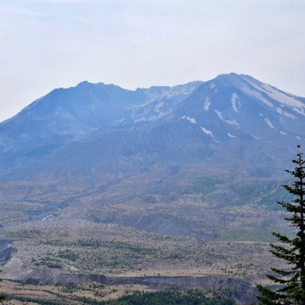
#MSH45 | A Changed Profile
Sure, Mount St. Helens’ new form would take getting used to.
But where reactions were once because of its ice cream cone-like slopes, now it was the ripped-open top that did the talking — snow gray with ash, the crater rim, steam drifting out under the moon.
Sure, Mount St. Helens’ new form would take getting used to.
But where reactions were once because of its ice cream cone-like slopes, now it was the ripped-open top that did the talking — snow gray with ash, the crater rim, steam drifting out under the moon.


December 12, 2025 at 12:26 AM
#MSH45 | A Changed Profile
Sure, Mount St. Helens’ new form would take getting used to.
But where reactions were once because of its ice cream cone-like slopes, now it was the ripped-open top that did the talking — snow gray with ash, the crater rim, steam drifting out under the moon.
Sure, Mount St. Helens’ new form would take getting used to.
But where reactions were once because of its ice cream cone-like slopes, now it was the ripped-open top that did the talking — snow gray with ash, the crater rim, steam drifting out under the moon.
April 6, 1980, and it’s the Easter Bunny’s turn in The Seattle Times.
It seems no one is safe—not even one hippity hoppitying across the forests of the Pacific Northwest—from the mountain's (potential) reach.
The bunny's fine, relax.
It seems no one is safe—not even one hippity hoppitying across the forests of the Pacific Northwest—from the mountain's (potential) reach.
The bunny's fine, relax.

December 11, 2025 at 3:18 AM
April 6, 1980, and it’s the Easter Bunny’s turn in The Seattle Times.
It seems no one is safe—not even one hippity hoppitying across the forests of the Pacific Northwest—from the mountain's (potential) reach.
The bunny's fine, relax.
It seems no one is safe—not even one hippity hoppitying across the forests of the Pacific Northwest—from the mountain's (potential) reach.
The bunny's fine, relax.
#MSH45 | Hijackers, Easter Eggs and a Volcano
April 2, 1980, Seattle Post-Intelligencer.
An editorial cartoon has hijacker D.B. Cooper hiding in a cabin in trademark shades, sporting a tropical shirt, while Mount St. Helens pelts “the law” outside with falling rocks.
Anything's possible, you know.
April 2, 1980, Seattle Post-Intelligencer.
An editorial cartoon has hijacker D.B. Cooper hiding in a cabin in trademark shades, sporting a tropical shirt, while Mount St. Helens pelts “the law” outside with falling rocks.
Anything's possible, you know.

December 11, 2025 at 3:18 AM
#MSH45 | Hijackers, Easter Eggs and a Volcano
April 2, 1980, Seattle Post-Intelligencer.
An editorial cartoon has hijacker D.B. Cooper hiding in a cabin in trademark shades, sporting a tropical shirt, while Mount St. Helens pelts “the law” outside with falling rocks.
Anything's possible, you know.
April 2, 1980, Seattle Post-Intelligencer.
An editorial cartoon has hijacker D.B. Cooper hiding in a cabin in trademark shades, sporting a tropical shirt, while Mount St. Helens pelts “the law” outside with falling rocks.
Anything's possible, you know.
This one's coming home to me!

December 10, 2025 at 6:16 PM
This one's coming home to me!
Great paintings, huh?
Well, here are two more Molenaar watercolors, including a post-eruption view from above Johnston Ridge and an annotated look at the recently changed mountain.
Well, here are two more Molenaar watercolors, including a post-eruption view from above Johnston Ridge and an annotated look at the recently changed mountain.


December 9, 2025 at 11:04 PM
Great paintings, huh?
Well, here are two more Molenaar watercolors, including a post-eruption view from above Johnston Ridge and an annotated look at the recently changed mountain.
Well, here are two more Molenaar watercolors, including a post-eruption view from above Johnston Ridge and an annotated look at the recently changed mountain.
#MSH45 | Watercolors
One of the most powerful “before and afters” of Mount St. Helens isn’t a photo at all, it’s this watercolor.
Legendary PNW mountaineer Dee Molenaar painted the graceful pre-1980 cone and Spirit Lake basin alongside the torn-open crater and devastated landscape that followed.
One of the most powerful “before and afters” of Mount St. Helens isn’t a photo at all, it’s this watercolor.
Legendary PNW mountaineer Dee Molenaar painted the graceful pre-1980 cone and Spirit Lake basin alongside the torn-open crater and devastated landscape that followed.

December 9, 2025 at 8:46 PM
#MSH45 | Watercolors
One of the most powerful “before and afters” of Mount St. Helens isn’t a photo at all, it’s this watercolor.
Legendary PNW mountaineer Dee Molenaar painted the graceful pre-1980 cone and Spirit Lake basin alongside the torn-open crater and devastated landscape that followed.
One of the most powerful “before and afters” of Mount St. Helens isn’t a photo at all, it’s this watercolor.
Legendary PNW mountaineer Dee Molenaar painted the graceful pre-1980 cone and Spirit Lake basin alongside the torn-open crater and devastated landscape that followed.
#MSH45 | May 7, 1980
Exploring the U.S. Geological Survey archives, we revisit the first week of May 1980, with a flight over quiet Mount St. Helens.
Later that afternoon, before 6 p.m., the volcano erupted after two weeks of quiet, releasing a small column of steam and ash.
Exploring the U.S. Geological Survey archives, we revisit the first week of May 1980, with a flight over quiet Mount St. Helens.
Later that afternoon, before 6 p.m., the volcano erupted after two weeks of quiet, releasing a small column of steam and ash.
December 6, 2025 at 3:27 AM
#MSH45 | May 7, 1980
Exploring the U.S. Geological Survey archives, we revisit the first week of May 1980, with a flight over quiet Mount St. Helens.
Later that afternoon, before 6 p.m., the volcano erupted after two weeks of quiet, releasing a small column of steam and ash.
Exploring the U.S. Geological Survey archives, we revisit the first week of May 1980, with a flight over quiet Mount St. Helens.
Later that afternoon, before 6 p.m., the volcano erupted after two weeks of quiet, releasing a small column of steam and ash.
If you’re in a position to give, I’d be grateful if you’d support one of these funds or organizations.
If you like having a target, a gift of $19.80 in honor of the 1980 eruption is a meaningful nod — but whatever amount works for you, or even just sharing the links, helps.
Thanks!
If you like having a target, a gift of $19.80 in honor of the 1980 eruption is a meaningful nod — but whatever amount works for you, or even just sharing the links, helps.
Thanks!

December 2, 2025 at 3:15 PM
If you’re in a position to give, I’d be grateful if you’d support one of these funds or organizations.
If you like having a target, a gift of $19.80 in honor of the 1980 eruption is a meaningful nod — but whatever amount works for you, or even just sharing the links, helps.
Thanks!
If you like having a target, a gift of $19.80 in honor of the 1980 eruption is a meaningful nod — but whatever amount works for you, or even just sharing the links, helps.
Thanks!
Closer to the mountain, Mount St. Helens Institute connects people to the volcano through science education, guided trips and volunteer stewardship, sharing the story of 1980 and the landscape that’s grown back.
@washingtontrails.bsky.social maintains and advocates for the trails that get us there.
@washingtontrails.bsky.social maintains and advocates for the trails that get us there.


December 2, 2025 at 3:15 PM
Closer to the mountain, Mount St. Helens Institute connects people to the volcano through science education, guided trips and volunteer stewardship, sharing the story of 1980 and the landscape that’s grown back.
@washingtontrails.bsky.social maintains and advocates for the trails that get us there.
@washingtontrails.bsky.social maintains and advocates for the trails that get us there.
The Harry Glicken Memorial Fellowship in @ucsantabarbara.bsky.social Earth Sciences honors the late volcanologist, who began his career at Mount St. Helens in 1980, and supports a doctoral student in volcanic processes and the detailed field and lab work Harry was known for.

December 2, 2025 at 3:15 PM
The Harry Glicken Memorial Fellowship in @ucsantabarbara.bsky.social Earth Sciences honors the late volcanologist, who began his career at Mount St. Helens in 1980, and supports a doctoral student in volcanic processes and the detailed field and lab work Harry was known for.
At @uwess.bsky.social, the David A. Johnston Memorial Fellowship Endowment supports grad students in geology and geophysics, honoring the late USGS volcanologist and alum.
Friends of Earthquakes backs seismic research and monitoring networks like @pnsn1.bsky.social—crucial back in 1980 and today.
Friends of Earthquakes backs seismic research and monitoring networks like @pnsn1.bsky.social—crucial back in 1980 and today.


December 2, 2025 at 3:15 PM
At @uwess.bsky.social, the David A. Johnston Memorial Fellowship Endowment supports grad students in geology and geophysics, honoring the late USGS volcanologist and alum.
Friends of Earthquakes backs seismic research and monitoring networks like @pnsn1.bsky.social—crucial back in 1980 and today.
Friends of Earthquakes backs seismic research and monitoring networks like @pnsn1.bsky.social—crucial back in 1980 and today.
#MSH45 | #GivingTuesday
It’s wild that we’re already in the home stretch of this 45th anniversary year.
If you’ve learned something here about Mount St. Helens or the science behind it, today’s a good time to support the people and programs keeping that work going.
Links to give in bio!
#PNW
It’s wild that we’re already in the home stretch of this 45th anniversary year.
If you’ve learned something here about Mount St. Helens or the science behind it, today’s a good time to support the people and programs keeping that work going.
Links to give in bio!
#PNW

December 2, 2025 at 3:15 PM
#MSH45 | #GivingTuesday
It’s wild that we’re already in the home stretch of this 45th anniversary year.
If you’ve learned something here about Mount St. Helens or the science behind it, today’s a good time to support the people and programs keeping that work going.
Links to give in bio!
#PNW
It’s wild that we’re already in the home stretch of this 45th anniversary year.
If you’ve learned something here about Mount St. Helens or the science behind it, today’s a good time to support the people and programs keeping that work going.
Links to give in bio!
#PNW
Back to July 22.
Here's a photo from Diane Kovacs Morin on the St. Johns Bridge showing one of the eruptive pulses from St. Helens.
Here's a photo from Diane Kovacs Morin on the St. Johns Bridge showing one of the eruptive pulses from St. Helens.

December 1, 2025 at 3:40 AM
Back to July 22.
Here's a photo from Diane Kovacs Morin on the St. Johns Bridge showing one of the eruptive pulses from St. Helens.
Here's a photo from Diane Kovacs Morin on the St. Johns Bridge showing one of the eruptive pulses from St. Helens.