


Trevor Heywood
@metroscapes.ca
Not all those who wander are lost. I explore Metroscapes, where natural and built environments collide.
🌐 https://metroscapes.ca
▶️ https://youtube.com/@metroscapes
🌐 https://metroscapes.ca
▶️ https://youtube.com/@metroscapes
But hey, I don't think you could ever top this.
November 11, 2025 at 5:31 AM
But hey, I don't think you could ever top this.
It includes little-known error state startup chimes that go off when a disc isn't read correctly, and it's creepy. Creepy dark video game history.

November 11, 2025 at 5:08 AM
It includes little-known error state startup chimes that go off when a disc isn't read correctly, and it's creepy. Creepy dark video game history.
Gotta give a shoutout to the bus drivers. My 99N driver pulled of a 155° turn, on a gradient, on undersalted concrete, with no juggle or slip. That's patience and discipline.

November 11, 2025 at 4:09 AM
Gotta give a shoutout to the bus drivers. My 99N driver pulled of a 155° turn, on a gradient, on undersalted concrete, with no juggle or slip. That's patience and discipline.
I don't like winter. Standing in a bus stop for 10 minutes feels a bit harsh. I'm not biologically adjusted to this yet.


November 11, 2025 at 3:35 AM
I don't like winter. Standing in a bus stop for 10 minutes feels a bit harsh. I'm not biologically adjusted to this yet.
Kicking off a bus ride listening to some KAYTRANADA.

November 11, 2025 at 3:03 AM
Kicking off a bus ride listening to some KAYTRANADA.
Naming complete, categorization is nearly there. Cross-referencing will be a bit of a slog, because it's slicing and dicing a parallel dataset.

November 10, 2025 at 12:16 AM
Naming complete, categorization is nearly there. Cross-referencing will be a bit of a slog, because it's slicing and dicing a parallel dataset.
I create my data in GIS and then export it to KML format to make it accessible to more people. I also need KML to load it into Google My Maps and embed it onto my site. But it's one of those datasets where it exceeds Google's size cap, so I had to simplify the geometry to reduce file size.

November 9, 2025 at 8:02 PM
I create my data in GIS and then export it to KML format to make it accessible to more people. I also need KML to load it into Google My Maps and embed it onto my site. But it's one of those datasets where it exceeds Google's size cap, so I had to simplify the geometry to reduce file size.
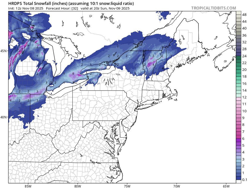
Cold air colliding with some moisture. It's gonna happen.
November 8, 2025 at 6:00 PM
Cold air colliding with some moisture. It's gonna happen.
I'm so mad. The City could consider appealing the OLT ruling for this. I wrote an email to Mayor Chow and Councillor Burnside, copying a bunch of other councillors. Alt text included.


November 6, 2025 at 6:06 PM
I'm so mad. The City could consider appealing the OLT ruling for this. I wrote an email to Mayor Chow and Councillor Burnside, copying a bunch of other councillors. Alt text included.
A Reddit post screen capped a version of the Metrolinx Wayfinding Design Standards that had the train lines lettered A-G. Kind of circular given that's how they used to do it. www.reddit.com/r/gotransit/...

November 5, 2025 at 7:54 PM
A Reddit post screen capped a version of the Metrolinx Wayfinding Design Standards that had the train lines lettered A-G. Kind of circular given that's how they used to do it. www.reddit.com/r/gotransit/...
I'm going to have to do some fundraising soon. This hobby creates a lot of data, and upgrading my storage is probably going to cost $1,000. That's on top of $700 of capital costs I put towards equipment in the last 2 years, $100 each year to run my website, and lots of gas and transit fare.

November 2, 2025 at 2:49 PM
I'm going to have to do some fundraising soon. This hobby creates a lot of data, and upgrading my storage is probably going to cost $1,000. That's on top of $700 of capital costs I put towards equipment in the last 2 years, $100 each year to run my website, and lots of gas and transit fare.
The corridor continues south to Lakeshore Road, where the last remaining structure stands. South of that, part of the corridor lives on as a garden until you hit the active construction zone for Lakeview Village. That's going to mark the end of today's long walk. Thanks for joining.


November 1, 2025 at 8:33 PM
The corridor continues south to Lakeshore Road, where the last remaining structure stands. South of that, part of the corridor lives on as a garden until you hit the active construction zone for Lakeview Village. That's going to mark the end of today's long walk. Thanks for joining.
The corridor goes south from the QEW, and does a bit of a jog at Halliday Avenue. This is where Season Creek appears as well. A bit further and it goes over the GO Transit Lakeshore West line. A remains of a spur to the Lakeview Generation Station offer an interesting perspective.


November 1, 2025 at 8:16 PM
The corridor goes south from the QEW, and does a bit of a jog at Halliday Avenue. This is where Season Creek appears as well. A bit further and it goes over the GO Transit Lakeshore West line. A remains of a spur to the Lakeview Generation Station offer an interesting perspective.
Ditching the main corridor to pursue a former branch. Using a new pedestrian bridge over the QEW, I got to this junction point. This corridor used to run to the Lakeview Generation Station, a coal-fired power plant on Mississauga's lakefront. The plant was demolished 20 years ago, so no wires here.


November 1, 2025 at 7:39 PM
Ditching the main corridor to pursue a former branch. Using a new pedestrian bridge over the QEW, I got to this junction point. This corridor used to run to the Lakeview Generation Station, a coal-fired power plant on Mississauga's lakefront. The plant was demolished 20 years ago, so no wires here.
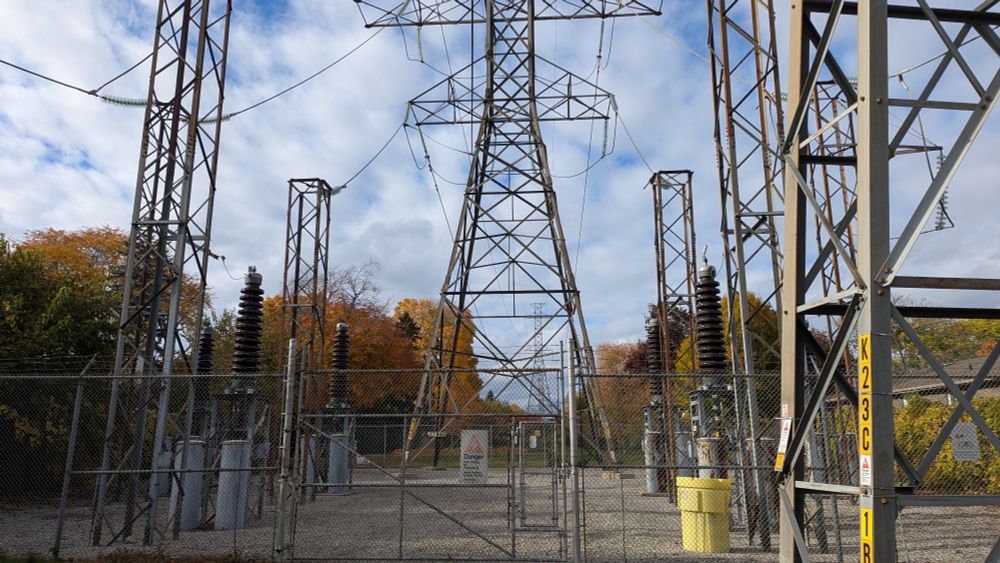
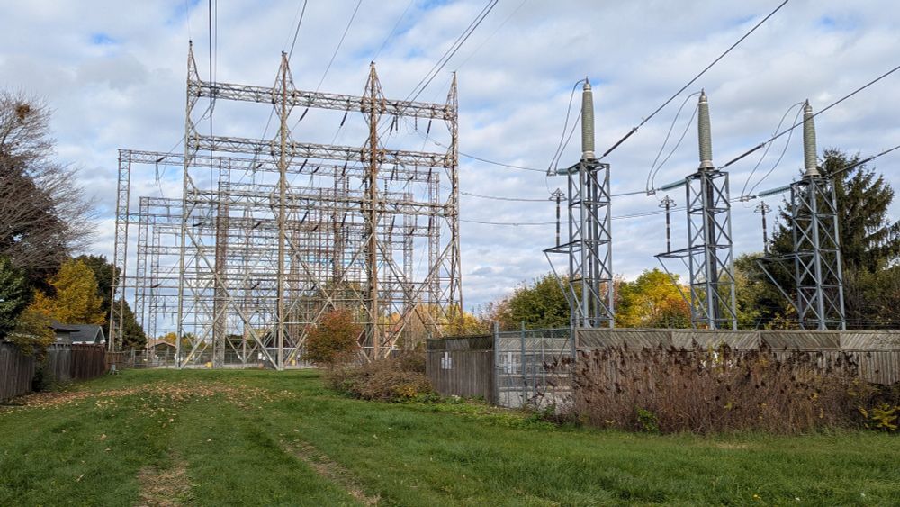
At Westfield Drive, the trail ends, and the hydro infrastructure gets a little crazy. One corridor splits off to the north, another plunges underground, and the spine of it all continues east. But the stations and junctions are fenced off in a way that you're boxed into a dead end.


November 1, 2025 at 7:16 PM
At Westfield Drive, the trail ends, and the hydro infrastructure gets a little crazy. One corridor splits off to the north, another plunges underground, and the spine of it all continues east. But the stations and junctions are fenced off in a way that you're boxed into a dead end.
At Westfield Drive, the trail ends, and the hydro infrastructure gets a little crazy. One corridor splits off to the north, another plunges underground, and the spine of it all continues east. But the stations and junctions are fenced off in a way that you're boxed into a dead end.
November 1, 2025 at 7:16 PM
At Westfield Drive, the trail ends, and the hydro infrastructure gets a little crazy. One corridor splits off to the north, another plunges underground, and the spine of it all continues east. But the stations and junctions are fenced off in a way that you're boxed into a dead end.
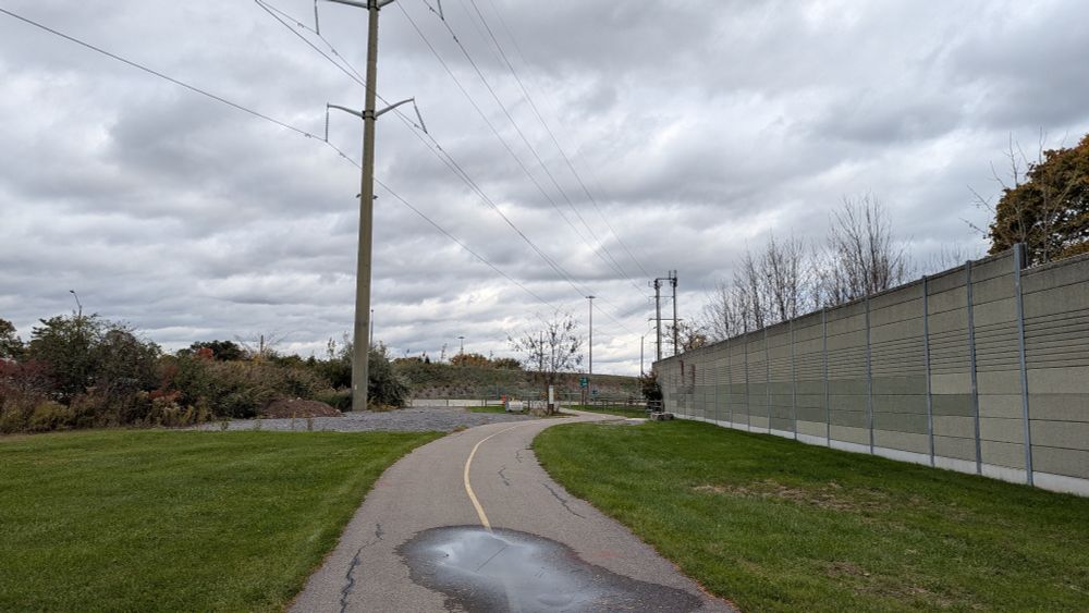
The trail continues in a typical fashion. West of Cawthra, the Cooksville Transformer Station will suggest you can't go through, but a footpath is firmly worn around it to provide a logical connection.


November 1, 2025 at 7:01 PM
The trail continues in a typical fashion. West of Cawthra, the Cooksville Transformer Station will suggest you can't go through, but a footpath is firmly worn around it to provide a logical connection.
The pedestrian bridge over the QEW at Stavebank and Pinetree is unfinished as well, so it's not until Hurontario that I see the corridor again, and even then, trying to navigate through the highway interchange was a whole circus. Back on corridor (and Nine Creeks Trail) east of Sherobee Road.


November 1, 2025 at 6:35 PM
The pedestrian bridge over the QEW at Stavebank and Pinetree is unfinished as well, so it's not until Hurontario that I see the corridor again, and even then, trying to navigate through the highway interchange was a whole circus. Back on corridor (and Nine Creeks Trail) east of Sherobee Road.
I totally blanked on this portion. As part of the QEW widening over the Credit River, a new multi-use trail will also connect the banks via its underside. But it's not done yet. So now I have to take a 7+ km detour to the next river crossing at Lakeshore Road to get back to the corridor.


November 1, 2025 at 5:14 PM
I totally blanked on this portion. As part of the QEW widening over the Credit River, a new multi-use trail will also connect the banks via its underside. But it's not done yet. So now I have to take a 7+ km detour to the next river crossing at Lakeshore Road to get back to the corridor.
The trail continues, across local roads and creeks until Woodeden Drive. Here, the Lorne Park Transformer Station offers some sketchy space around its perimeter, but it's not ideal, and is a major gap in the trail.


November 1, 2025 at 4:52 PM
The trail continues, across local roads and creeks until Woodeden Drive. Here, the Lorne Park Transformer Station offers some sketchy space around its perimeter, but it's not ideal, and is a major gap in the trail.
Across a couple local roads and then you get to the longest creek bridge yet, presumably to accommodate a meander belt and/or wetland. Then towards and through Whiteoaks Park. This is surprisingly well vegetated for a combo corridor. Across another creek, and past a school and library.


November 1, 2025 at 4:20 PM
Across a couple local roads and then you get to the longest creek bridge yet, presumably to accommodate a meander belt and/or wetland. Then towards and through Whiteoaks Park. This is surprisingly well vegetated for a combo corridor. Across another creek, and past a school and library.
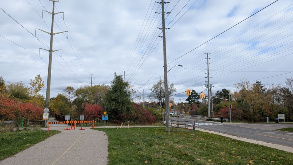
The trail steers you to the intersection at Southdown and Hartland to cross. Then it's onwards across another creek and past a pipeline junction, presumably to the pier at the Mississauga Lubricants Centre.


November 1, 2025 at 3:57 PM
The trail steers you to the intersection at Southdown and Hartland to cross. Then it's onwards across another creek and past a pipeline junction, presumably to the pier at the Mississauga Lubricants Centre.
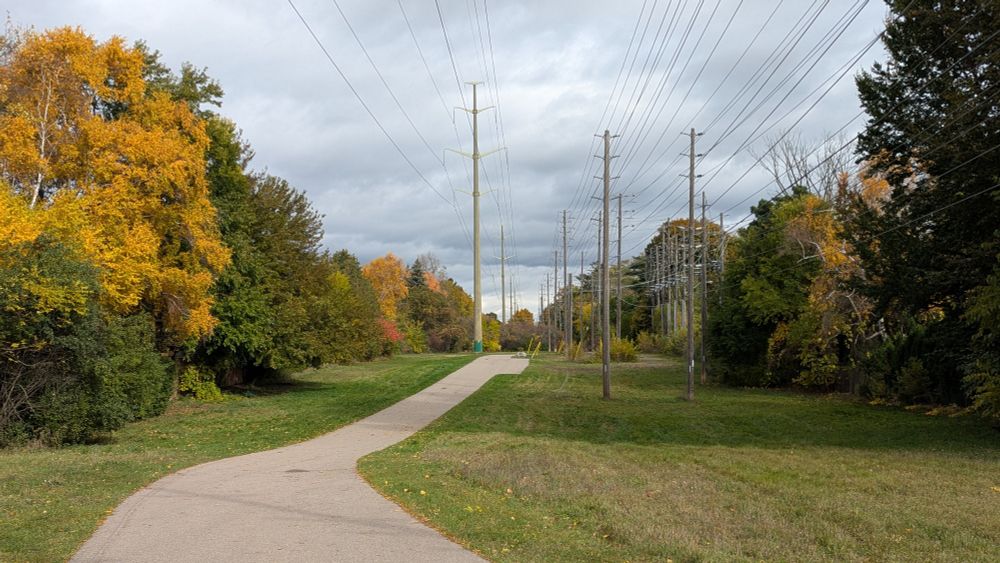
Onwards down the meandering trail, and past a playground. Across Bromsgrove at a formal crossing, and around a small construction zone to get to the first creek crossing. This is also a connection to the Sheridan Creek Trail and Clarkson GO Station.


November 1, 2025 at 3:41 PM
Onwards down the meandering trail, and past a playground. Across Bromsgrove at a formal crossing, and around a small construction zone to get to the first creek crossing. This is also a connection to the Sheridan Creek Trail and Clarkson GO Station.
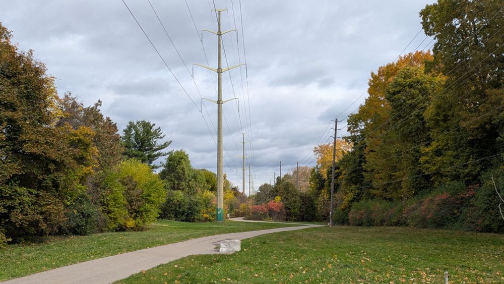
After a bit, I cross the Oakville-Mississauga border. This also marks a transition from a gravel truck road to a formal multi-use trail. This is the Nine Creeks Trail. There's also an off-road bike park here. Overall, a more efficient use of the utility corridor.
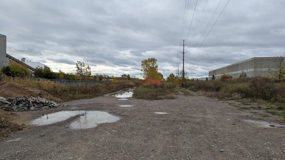


November 1, 2025 at 3:24 PM
After a bit, I cross the Oakville-Mississauga border. This also marks a transition from a gravel truck road to a formal multi-use trail. This is the Nine Creeks Trail. There's also an off-road bike park here. Overall, a more efficient use of the utility corridor.