


Matthew Cappucci
@matthewcappucci.bsky.social
Senior meteorologist. MyRadar. Washington Post/NPR/TV too. Atmospheric scientist. Educational consultant. Harvard/MIT ‘19.
Reposted by Matthew Cappucci

@matthewcappucci.bsky.social constantly impresses me with his meteorology writing and speaking.
October 28, 2025 at 12:55 AM
@matthewcappucci.bsky.social constantly impresses me with his meteorology writing and speaking.
Reposted by Matthew Cappucci

Vivid writing by @matthewcappucci.bsky.social about a flight aboard @noaa.gov’s “Kermit” into the eyewall of Hurricane Melissa. Cappucci conveys the power of a Cat 5 hurricane bearing down on Jamaica. [gift link] wapo.st/3L7FWMs

Analysis | What it was like to fly into Hurricane Melissa’s eye
I was sitting in the middle of a 10-mile-wide stadium of the gods. On all sides, hulking thunderstorms towered high above. Just miles in any direction, a hellish-monster creating unsurvivable conditio...
wapo.st
October 27, 2025 at 11:36 PM
Vivid writing by @matthewcappucci.bsky.social about a flight aboard @noaa.gov’s “Kermit” into the eyewall of Hurricane Melissa. Cappucci conveys the power of a Cat 5 hurricane bearing down on Jamaica. [gift link] wapo.st/3L7FWMs
Reposted by Matthew Cappucci

The remnants of Tropical Storm Mario will bring scattered heavy downpours, isolated strong to severe thunderstorms, and the potential for flooding to southern California.
MyRadar meteorologist @matthewcappucci.bsky.social has an update.
MyRadar meteorologist @matthewcappucci.bsky.social has an update.

Southern California Storms
This is "Southern California Storms" by MyRadar on Vimeo, the home for high quality videos and the people who love them.
vimeo.com
September 18, 2025 at 7:44 PM
The remnants of Tropical Storm Mario will bring scattered heavy downpours, isolated strong to severe thunderstorms, and the potential for flooding to southern California.
MyRadar meteorologist @matthewcappucci.bsky.social has an update.
MyRadar meteorologist @matthewcappucci.bsky.social has an update.
Reposted by Matthew Cappucci
It’s peak hurricane season. 75 percent of all tropical cyclone activity occurs between August 20 and October 20.
The season has been quiet for the U.S. so far, but that could change in mid-September.
MyRadar meteorologist @matthewcappucci.bsky.social has an update for peak season.
The season has been quiet for the U.S. so far, but that could change in mid-September.
MyRadar meteorologist @matthewcappucci.bsky.social has an update for peak season.

Peak Hurricane Season Arrives - What You Need to Know
YouTube video by MyRadar Weather News
youtu.be
August 21, 2025 at 8:12 PM
It’s peak hurricane season. 75 percent of all tropical cyclone activity occurs between August 20 and October 20.
The season has been quiet for the U.S. so far, but that could change in mid-September.
MyRadar meteorologist @matthewcappucci.bsky.social has an update for peak season.
The season has been quiet for the U.S. so far, but that could change in mid-September.
MyRadar meteorologist @matthewcappucci.bsky.social has an update for peak season.
Reposted by Matthew Cappucci
Imagine getting hit by two tornadoes in just 41 minutes. That’s what happened near Bassfield, MS on March 15. During the high risk outbreak, overlapping tornado paths struck the same area—an intense and rare event caught on radar and maps.
Meteorologist @matthewcappucci.bsky.social explains.
Meteorologist @matthewcappucci.bsky.social explains.
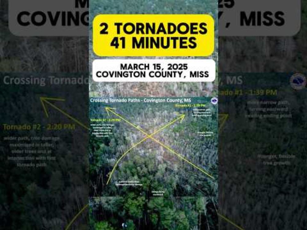
Two Tornadoes. One Town. 41 Minutes Apart.
YouTube video by MyRadar Weather News
youtube.com
March 21, 2025 at 5:59 PM
Imagine getting hit by two tornadoes in just 41 minutes. That’s what happened near Bassfield, MS on March 15. During the high risk outbreak, overlapping tornado paths struck the same area—an intense and rare event caught on radar and maps.
Meteorologist @matthewcappucci.bsky.social explains.
Meteorologist @matthewcappucci.bsky.social explains.
FOX35 just got hit by a tornado LIVE ON AIR! Tornado just passed Lake Mary and is heading toward Orlando’s Sanford International Airport!
March 10, 2025 at 1:52 PM
FOX35 just got hit by a tornado LIVE ON AIR! Tornado just passed Lake Mary and is heading toward Orlando’s Sanford International Airport!
A cross-country storm system is about to bring a tornado risk from Oklahoma all the way to Maryland:
www.washingtonpost.com/weather/2025...
www.washingtonpost.com/weather/2025...
Cross-country storm to bring tornado risk from Oklahoma to Maryland
The storm could spawn severe weather from Sunday to Wednesday as it moves east and north. The forecast isn’t certain but Tuesday could include a tornado risk.
www.washingtonpost.com
March 2, 2025 at 8:40 PM
A cross-country storm system is about to bring a tornado risk from Oklahoma all the way to Maryland:
www.washingtonpost.com/weather/2025...
www.washingtonpost.com/weather/2025...
There is a slight chance of a bit of #thundersnow in NYC as a bit of elevated instability, or thunderstorm fuel at the atmosphere’s mid levels, works through.
Plus the tall buildings are effective at focusing the diffuse lower positive charge found in snow clouds. @myradar.bsky.social
Plus the tall buildings are effective at focusing the diffuse lower positive charge found in snow clouds. @myradar.bsky.social
February 6, 2025 at 2:57 AM
There is a slight chance of a bit of #thundersnow in NYC as a bit of elevated instability, or thunderstorm fuel at the atmosphere’s mid levels, works through.
Plus the tall buildings are effective at focusing the diffuse lower positive charge found in snow clouds. @myradar.bsky.social
Plus the tall buildings are effective at focusing the diffuse lower positive charge found in snow clouds. @myradar.bsky.social
A thump of heavy snow will move along I-95 tomorrow morning between NYC and Boston.
Why? Frontogenesis.
Changing temperatures make a density ramp in the atmosphere that moisture rises up. That moisture comes back down as heavy snow. @myradar.bsky.social
Why? Frontogenesis.
Changing temperatures make a density ramp in the atmosphere that moisture rises up. That moisture comes back down as heavy snow. @myradar.bsky.social
February 6, 2025 at 2:49 AM
A thump of heavy snow will move along I-95 tomorrow morning between NYC and Boston.
Why? Frontogenesis.
Changing temperatures make a density ramp in the atmosphere that moisture rises up. That moisture comes back down as heavy snow. @myradar.bsky.social
Why? Frontogenesis.
Changing temperatures make a density ramp in the atmosphere that moisture rises up. That moisture comes back down as heavy snow. @myradar.bsky.social
Reposted by Matthew Cappucci
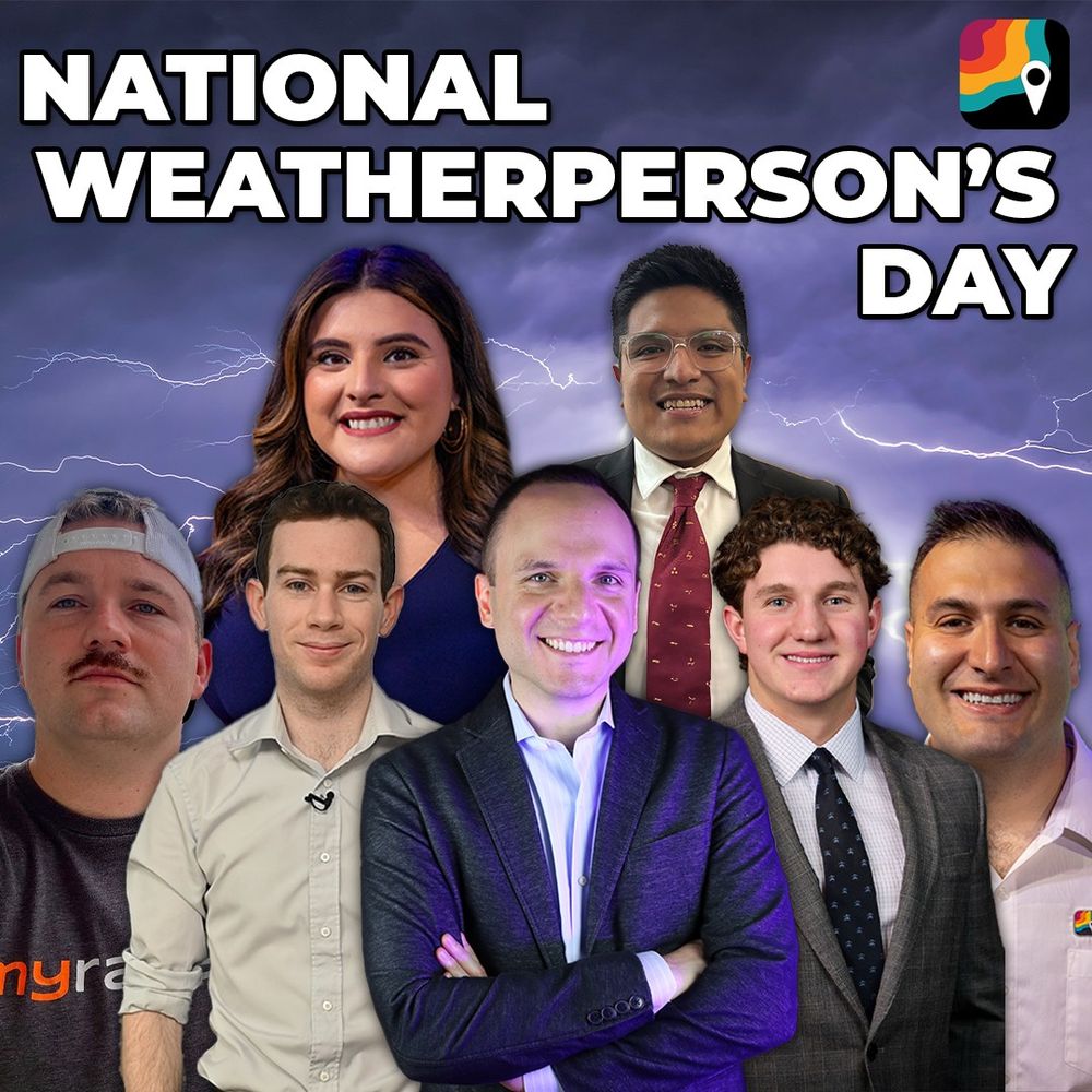
Happy National Weatherperson’s Day! 🌀🌪️
Celebrating the MyRadar weather team and all the meteorologists and weather forecasters who keep us safe and informed, rain or shine!
Celebrating the MyRadar weather team and all the meteorologists and weather forecasters who keep us safe and informed, rain or shine!
February 5, 2025 at 10:04 PM
Happy National Weatherperson’s Day! 🌀🌪️
Celebrating the MyRadar weather team and all the meteorologists and weather forecasters who keep us safe and informed, rain or shine!
Celebrating the MyRadar weather team and all the meteorologists and weather forecasters who keep us safe and informed, rain or shine!
Reposted by Matthew Cappucci
An approaching slow pressure system could deposit a dangerous glaze of ice from Chicago to Columbus to Pittsburgh to Washington D.C. on Wednesday night or Thursday morning.
Meteorologist @matthewcappucci.bsky.social takes an early look at the setup.
Meteorologist @matthewcappucci.bsky.social takes an early look at the setup.
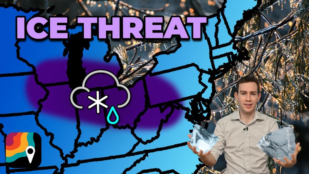
Ice danger across Midwest, Mid-Atlantic
An approaching slow pressure system could deposit a dangerous glaze of ice from Chicago to Columbus to Pittsburgh to Washington D.C. on Wednesday night or Thursday…
vimeo.com
February 4, 2025 at 6:56 PM
An approaching slow pressure system could deposit a dangerous glaze of ice from Chicago to Columbus to Pittsburgh to Washington D.C. on Wednesday night or Thursday morning.
Meteorologist @matthewcappucci.bsky.social takes an early look at the setup.
Meteorologist @matthewcappucci.bsky.social takes an early look at the setup.
Reposted by Matthew Cappucci
A hazardous glaze of freezing rain will fall from near Chicago to Washington D.C. overnight Wednesday into Thursday morning.
Thunder may accompany the freezing rain.
MyRadar meteorologist @matthewcappucci.bsky.social breaks down the icing hazard.
Thunder may accompany the freezing rain.
MyRadar meteorologist @matthewcappucci.bsky.social breaks down the icing hazard.
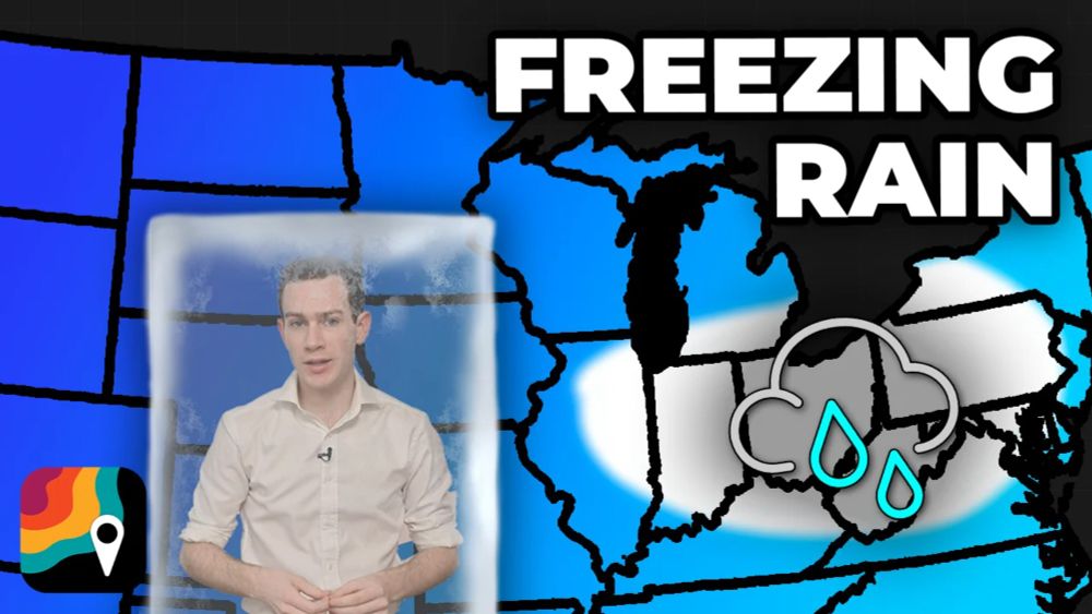
Freezing rain in the Eastern U.S.
A hazardous glaze of freezing rain will fall from near Chicago to Washington D.C. overnight Wednesday into Thursday morning. Thunder may accompany the freezing rain.…
vimeo.com
February 5, 2025 at 6:04 PM
A hazardous glaze of freezing rain will fall from near Chicago to Washington D.C. overnight Wednesday into Thursday morning.
Thunder may accompany the freezing rain.
MyRadar meteorologist @matthewcappucci.bsky.social breaks down the icing hazard.
Thunder may accompany the freezing rain.
MyRadar meteorologist @matthewcappucci.bsky.social breaks down the icing hazard.
Reposted by Matthew Cappucci

Same. Same. He brought a little tear to my eye. @matthewcappucci.bsky.social is a treasure.
My day is a little happier when @matthewcappucci.bsky.social does the weather in WAMU. Instead of endearing lightheartedness, this morning he showed empathy for a region struggling with a lot. "Be nice to your neighbors." Thank you for always projecting kindness, especially now.
January 30, 2025 at 5:01 PM
Same. Same. He brought a little tear to my eye. @matthewcappucci.bsky.social is a treasure.
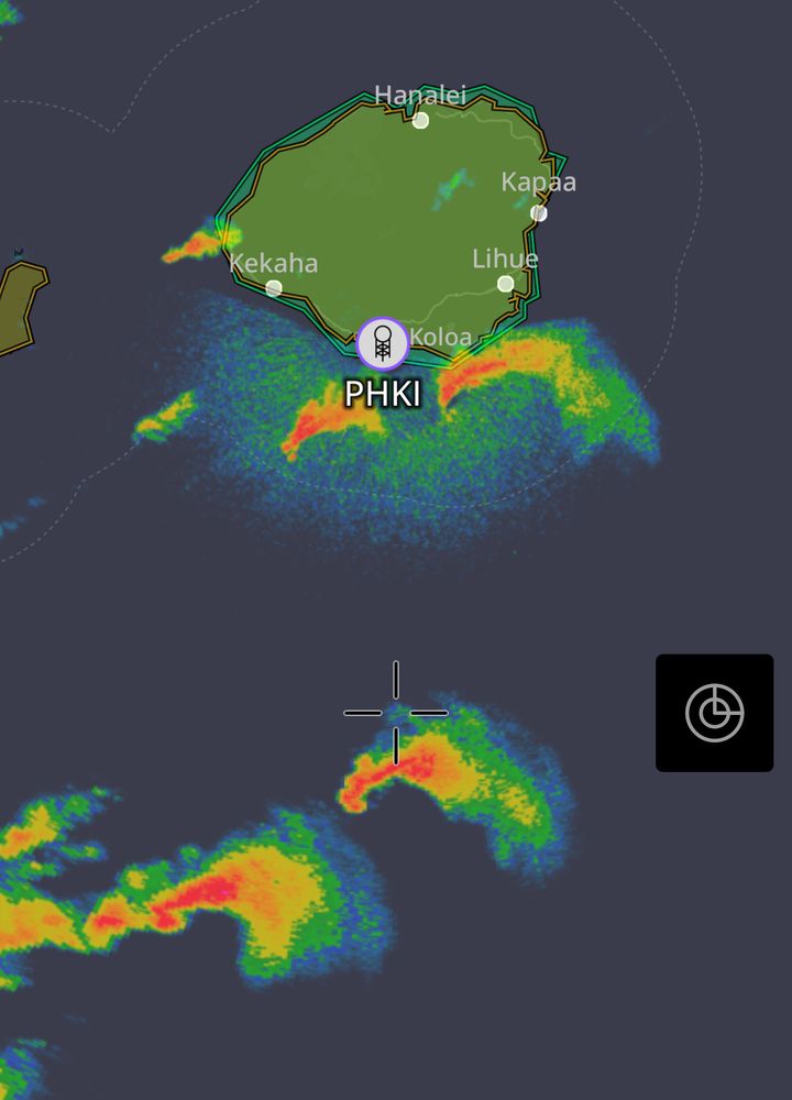
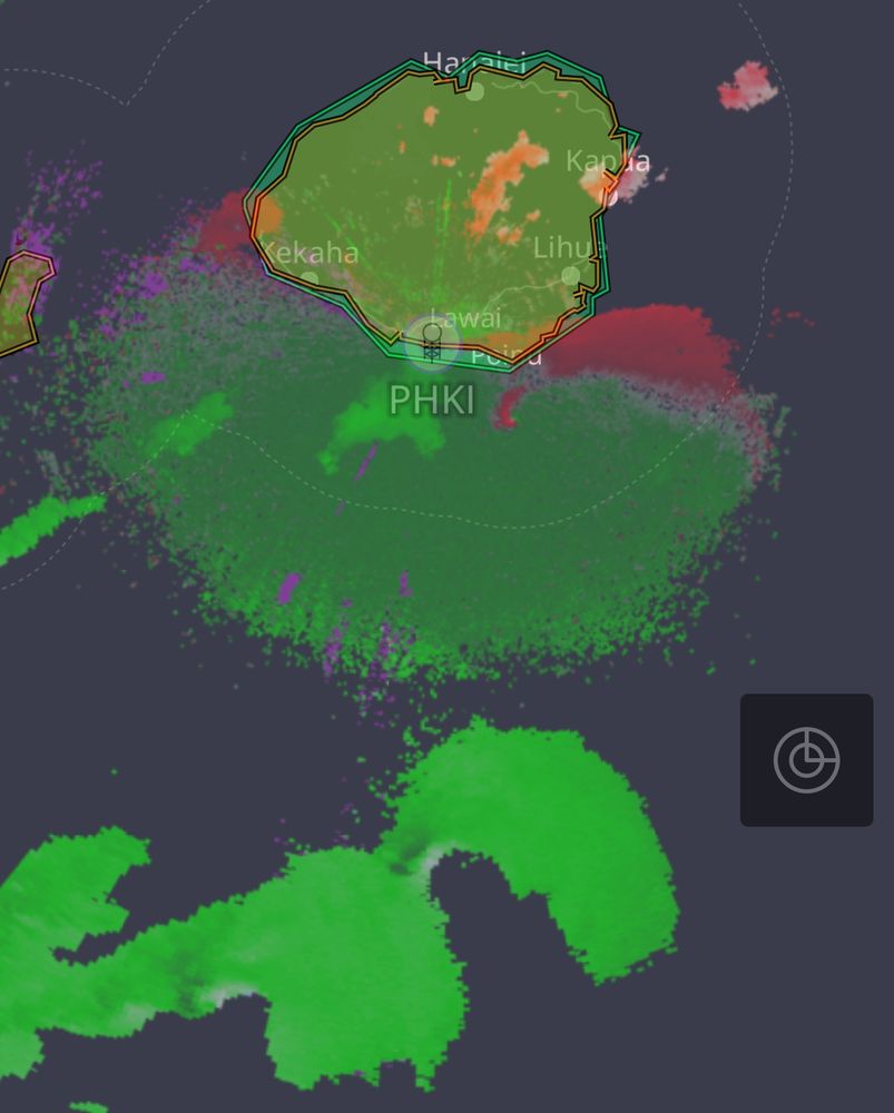
Supercell outbreak in HAWAII! These rotating supercells are producing tornadic waterspouts.
Tornadoes are possible, particularly near Kauai in the next few hours. Track the latest in the @myradar.bsky.social app.
Tornadoes are possible, particularly near Kauai in the next few hours. Track the latest in the @myradar.bsky.social app.
January 30, 2025 at 4:48 PM
Supercell outbreak in HAWAII! These rotating supercells are producing tornadic waterspouts.
Tornadoes are possible, particularly near Kauai in the next few hours. Track the latest in the @myradar.bsky.social app.
Tornadoes are possible, particularly near Kauai in the next few hours. Track the latest in the @myradar.bsky.social app.
Reposted by Matthew Cappucci

My day is a little happier when @matthewcappucci.bsky.social does the weather in WAMU. Instead of endearing lightheartedness, this morning he showed empathy for a region struggling with a lot. "Be nice to your neighbors." Thank you for always projecting kindness, especially now.
January 30, 2025 at 12:38 PM
My day is a little happier when @matthewcappucci.bsky.social does the weather in WAMU. Instead of endearing lightheartedness, this morning he showed empathy for a region struggling with a lot. "Be nice to your neighbors." Thank you for always projecting kindness, especially now.
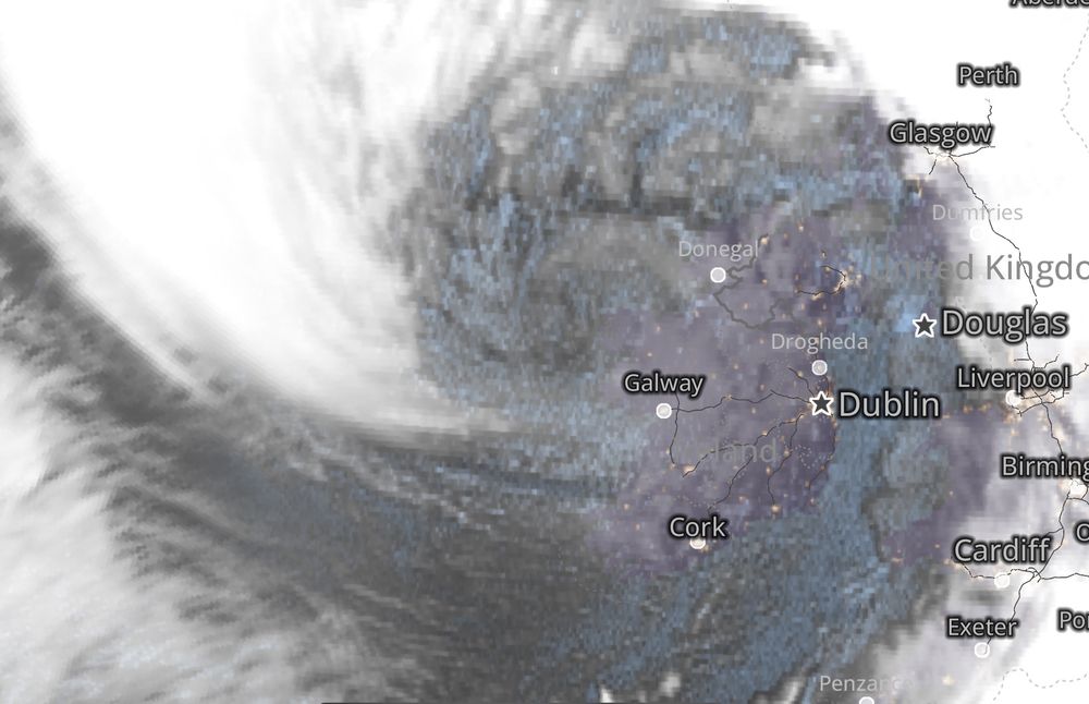
WOW! The sting jet is about to hit Galway! See the pointy cloud? That’s the “stinger” as seen in @myradar.bsky.social!
Shannon Airport has already gusted to 78 mph; Dublin has gusted to 60 mph.
Galway should be ready for winds gusting 90-100 mph over the next few hours. #StormEowyn
Shannon Airport has already gusted to 78 mph; Dublin has gusted to 60 mph.
Galway should be ready for winds gusting 90-100 mph over the next few hours. #StormEowyn
January 24, 2025 at 4:16 AM
WOW! The sting jet is about to hit Galway! See the pointy cloud? That’s the “stinger” as seen in @myradar.bsky.social!
Shannon Airport has already gusted to 78 mph; Dublin has gusted to 60 mph.
Galway should be ready for winds gusting 90-100 mph over the next few hours. #StormEowyn
Shannon Airport has already gusted to 78 mph; Dublin has gusted to 60 mph.
Galway should be ready for winds gusting 90-100 mph over the next few hours. #StormEowyn
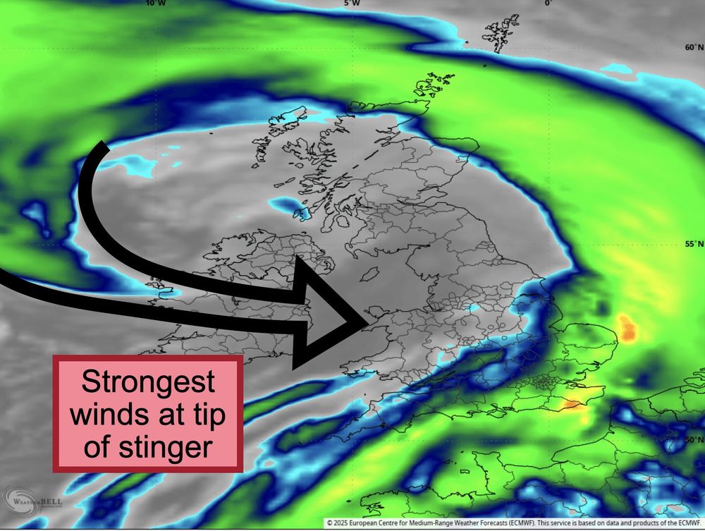
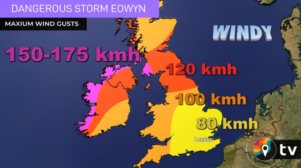
Tonight will feature dangerously strong winds in Ireland, with gusts over 100 mph at the coastline as a "sting jet" descends to the ground.
Much of the United Kingdom will face winds approaching hurricane force.
Plan for damage and power outages. @myradar.bsky.social update coming.
Much of the United Kingdom will face winds approaching hurricane force.
Plan for damage and power outages. @myradar.bsky.social update coming.
January 23, 2025 at 5:51 PM
Tonight will feature dangerously strong winds in Ireland, with gusts over 100 mph at the coastline as a "sting jet" descends to the ground.
Much of the United Kingdom will face winds approaching hurricane force.
Plan for damage and power outages. @myradar.bsky.social update coming.
Much of the United Kingdom will face winds approaching hurricane force.
Plan for damage and power outages. @myradar.bsky.social update coming.
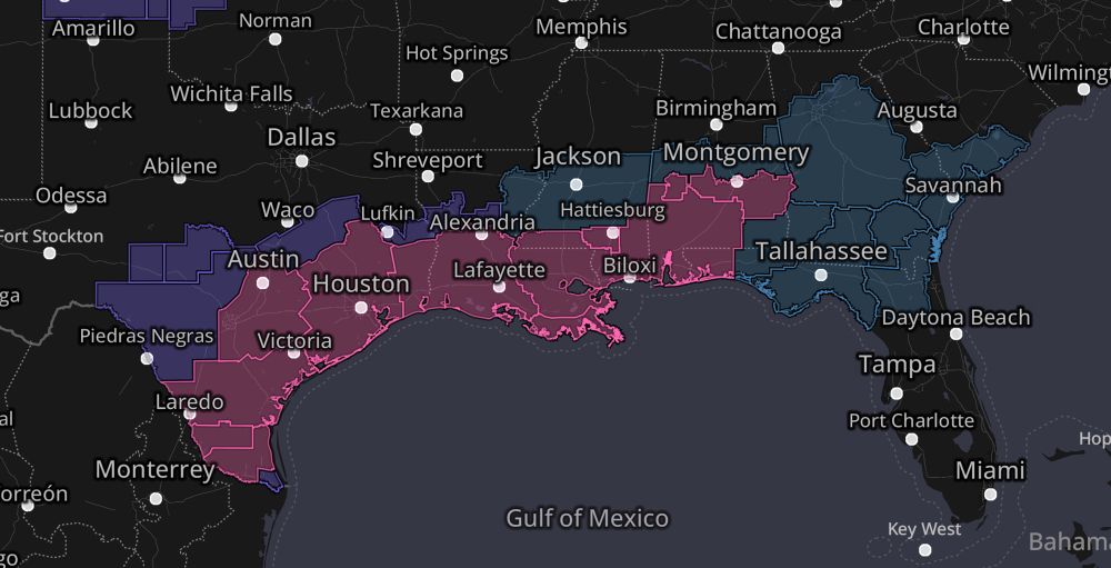
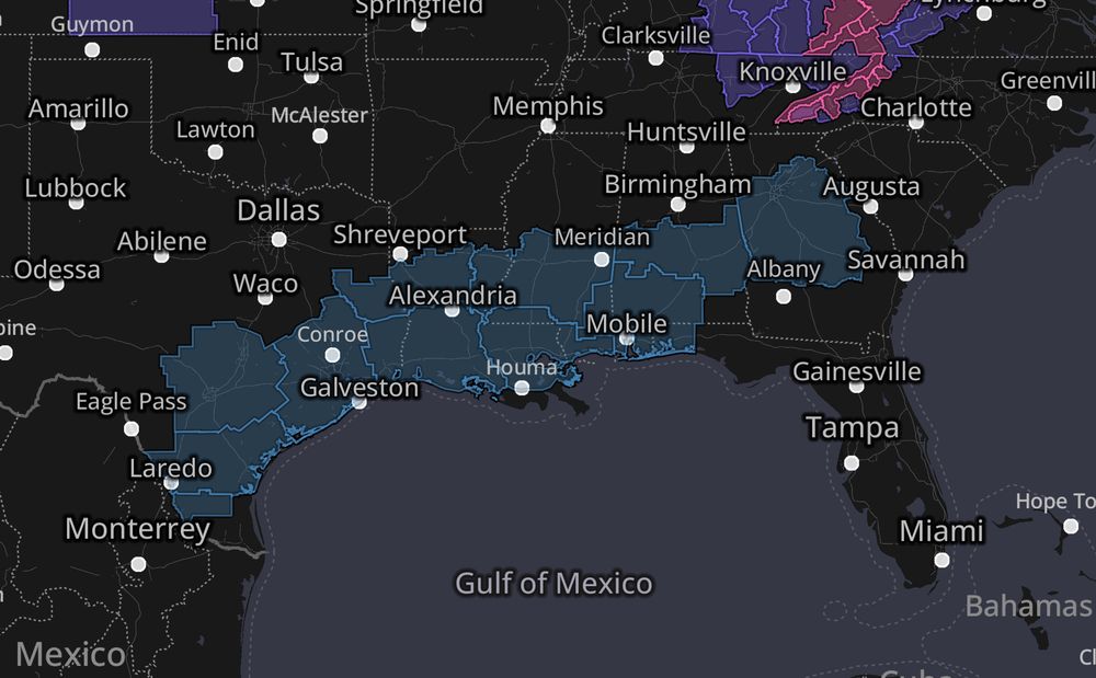
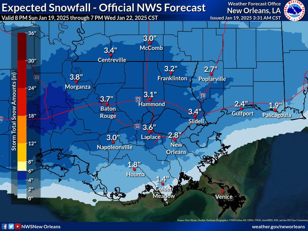
A historic winter storm, complete with half a foot of snow in the Louisiana bayous, is shaping up for the Gulf Coast.
Winter storm warnings span from the Mexican border to coastal Georgia.
Snow will cover palm trees.🌴This is rare and exceptional.
Winter storm warnings span from the Mexican border to coastal Georgia.
Snow will cover palm trees.🌴This is rare and exceptional.
January 20, 2025 at 11:39 PM
A historic winter storm, complete with half a foot of snow in the Louisiana bayous, is shaping up for the Gulf Coast.
Winter storm warnings span from the Mexican border to coastal Georgia.
Snow will cover palm trees.🌴This is rare and exceptional.
Winter storm warnings span from the Mexican border to coastal Georgia.
Snow will cover palm trees.🌴This is rare and exceptional.
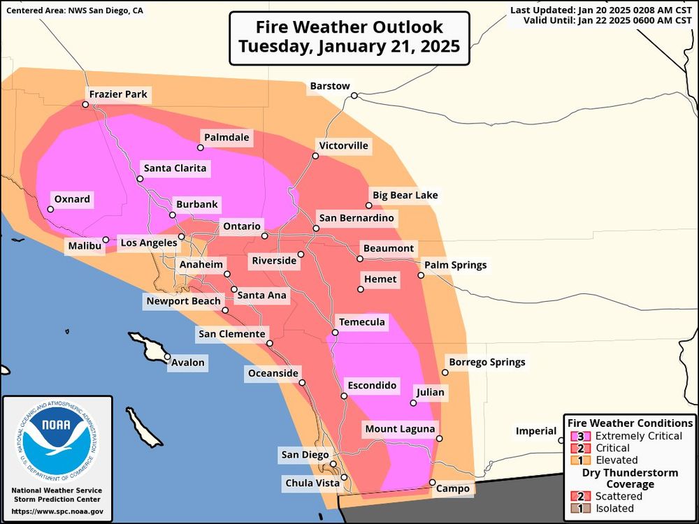
PDS — or Particularly Dangerous Situation — red flag warning for Los Angeles and Ventura Counties.
HUGE danger if any new fires crop up. This danger will continue, potentially with disastrous results, until widespread rain arrives in Southern California.
HUGE danger if any new fires crop up. This danger will continue, potentially with disastrous results, until widespread rain arrives in Southern California.
January 20, 2025 at 11:39 PM
PDS — or Particularly Dangerous Situation — red flag warning for Los Angeles and Ventura Counties.
HUGE danger if any new fires crop up. This danger will continue, potentially with disastrous results, until widespread rain arrives in Southern California.
HUGE danger if any new fires crop up. This danger will continue, potentially with disastrous results, until widespread rain arrives in Southern California.
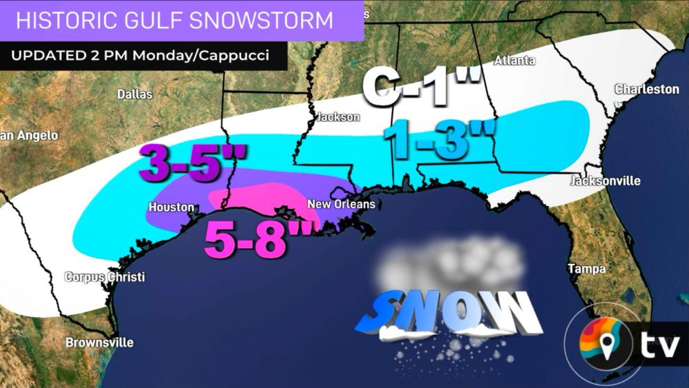
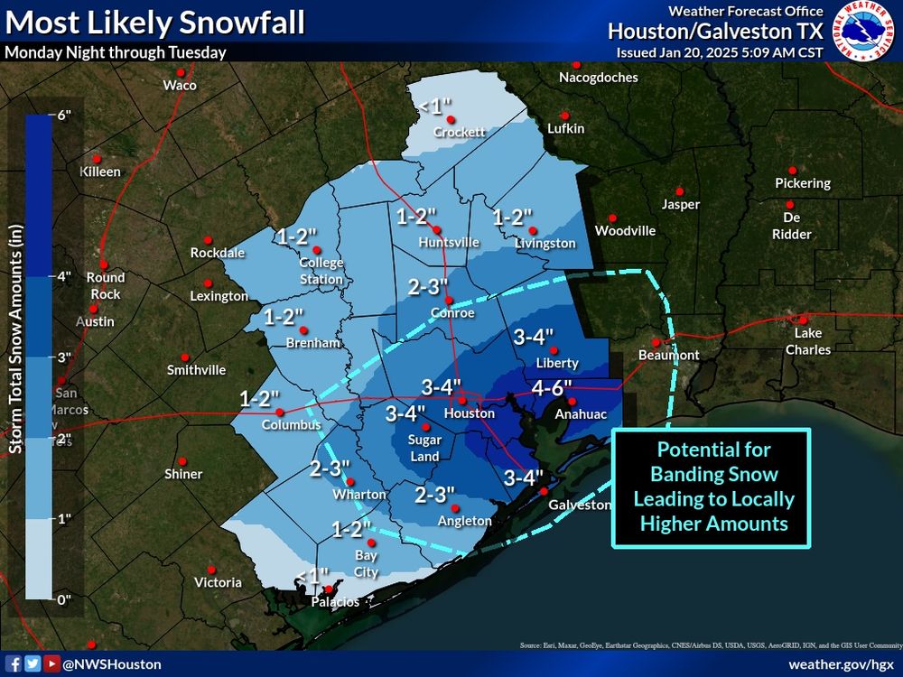
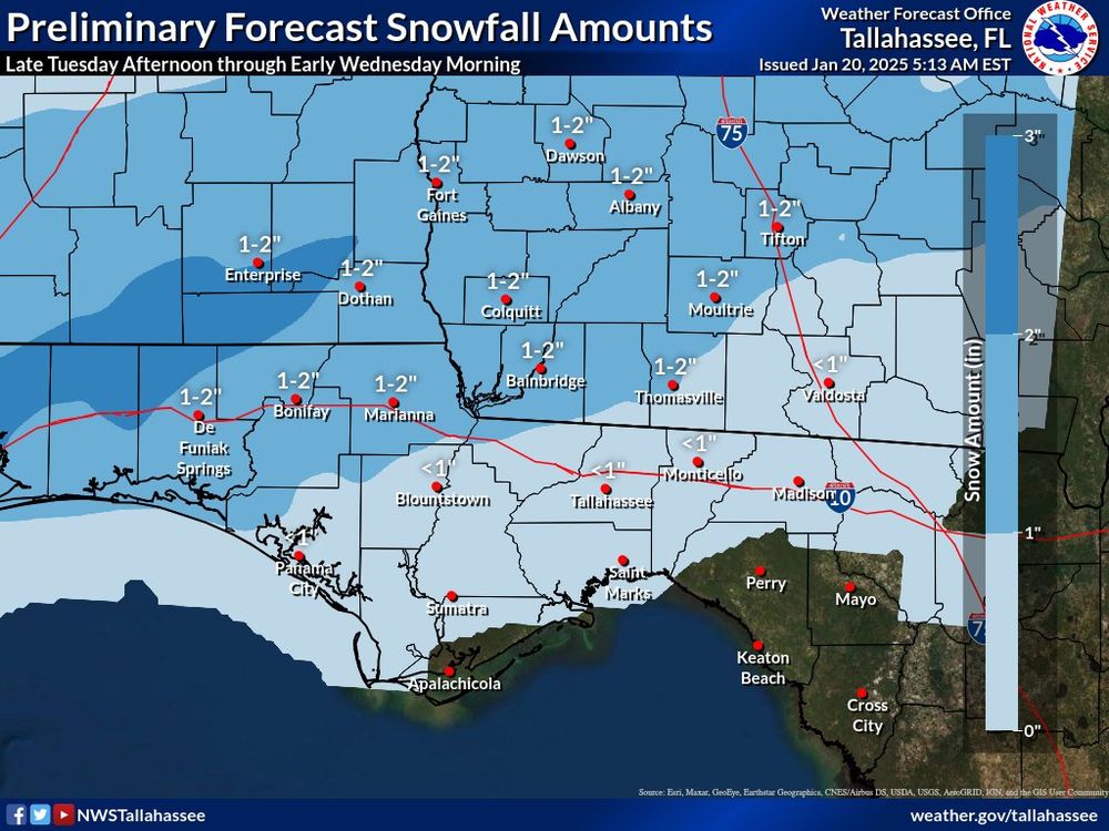
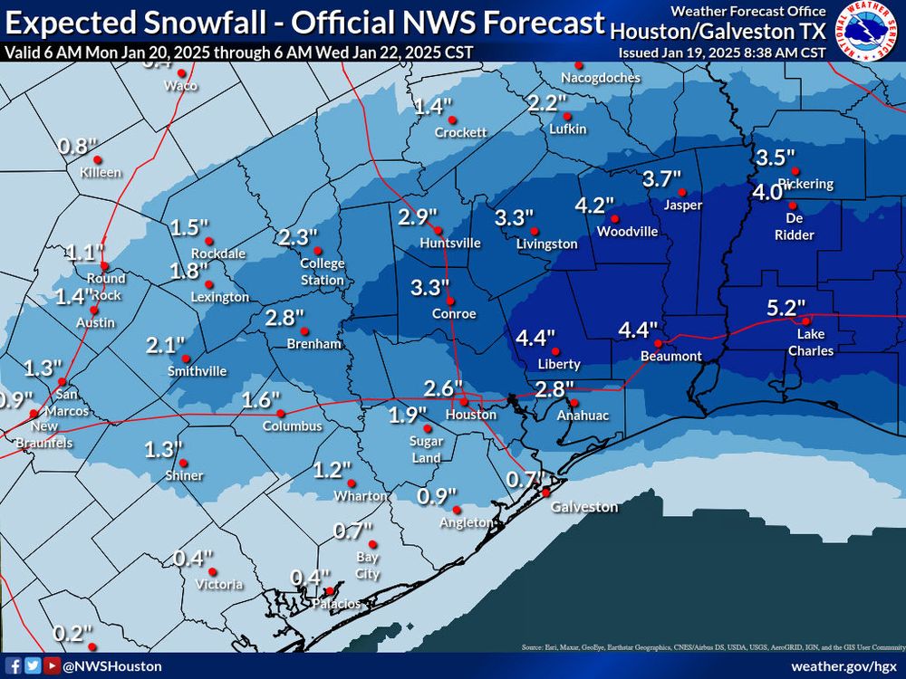
An absolutely historic winter storm is in the cards for the Gulf Coast!
Winter storm warnings stretch from the Mexican border to the Florida Panhandle. Widespread 2-4” totals are likely, including in Houston and New Orleans
.
Panama City might even see an inch or two!
WOW. ❄️
Winter storm warnings stretch from the Mexican border to the Florida Panhandle. Widespread 2-4” totals are likely, including in Houston and New Orleans
.
Panama City might even see an inch or two!
WOW. ❄️
January 20, 2025 at 6:02 PM
An absolutely historic winter storm is in the cards for the Gulf Coast!
Winter storm warnings stretch from the Mexican border to the Florida Panhandle. Widespread 2-4” totals are likely, including in Houston and New Orleans
.
Panama City might even see an inch or two!
WOW. ❄️
Winter storm warnings stretch from the Mexican border to the Florida Panhandle. Widespread 2-4” totals are likely, including in Houston and New Orleans
.
Panama City might even see an inch or two!
WOW. ❄️
WOW! Winter storm for the Gulf Coast!
Winter storm watches stretch from the Mexican border to Atlanta.
Houston will see 2-4 inches of snow. So will New Orleans! Even snow on the TX Barriwr Islands!
A rare, significant winter storm for places where palm trees are ubiquitous! 🌴
Winter storm watches stretch from the Mexican border to Atlanta.
Houston will see 2-4 inches of snow. So will New Orleans! Even snow on the TX Barriwr Islands!
A rare, significant winter storm for places where palm trees are ubiquitous! 🌴
January 19, 2025 at 3:02 PM
WOW! Winter storm for the Gulf Coast!
Winter storm watches stretch from the Mexican border to Atlanta.
Houston will see 2-4 inches of snow. So will New Orleans! Even snow on the TX Barriwr Islands!
A rare, significant winter storm for places where palm trees are ubiquitous! 🌴
Winter storm watches stretch from the Mexican border to Atlanta.
Houston will see 2-4 inches of snow. So will New Orleans! Even snow on the TX Barriwr Islands!
A rare, significant winter storm for places where palm trees are ubiquitous! 🌴
Reposted by Matthew Cappucci
Los Angeles saw two winters with DOUBLE the normal rainfall. Then it stopped raining altogether. It’s a perfect recipe for extreme fires.
Meteorologist @matthewcappucci.bsky.social breaks it down.
Meteorologist @matthewcappucci.bsky.social breaks it down.

🔥🌧️ Rain, Drought, Wildfire: LA’s New Normal?
YouTube video by MyRadar Weather News
youtube.com
January 14, 2025 at 4:15 PM
Los Angeles saw two winters with DOUBLE the normal rainfall. Then it stopped raining altogether. It’s a perfect recipe for extreme fires.
Meteorologist @matthewcappucci.bsky.social breaks it down.
Meteorologist @matthewcappucci.bsky.social breaks it down.
Reposted by Matthew Cappucci
Meteorologist @matthewcappucci.bsky.social breaks down the BIGGEST mistake we make with wildfires.
The BIGGEST Mistake We’re Making About Wildfires 🔥
YouTube video by MyRadar Weather News
youtube.com
January 14, 2025 at 6:31 PM
Meteorologist @matthewcappucci.bsky.social breaks down the BIGGEST mistake we make with wildfires.
Reposted by Matthew Cappucci
The Palisades Fire burned more energy than the entire city of Los Angeles used in 2 years. That’s a LOT of heat release.
Meteorologist @matthewcappucci.bsky.social explains. #wildfires #palisadesfire #california #losangeles #fire
Meteorologist @matthewcappucci.bsky.social explains. #wildfires #palisadesfire #california #losangeles #fire
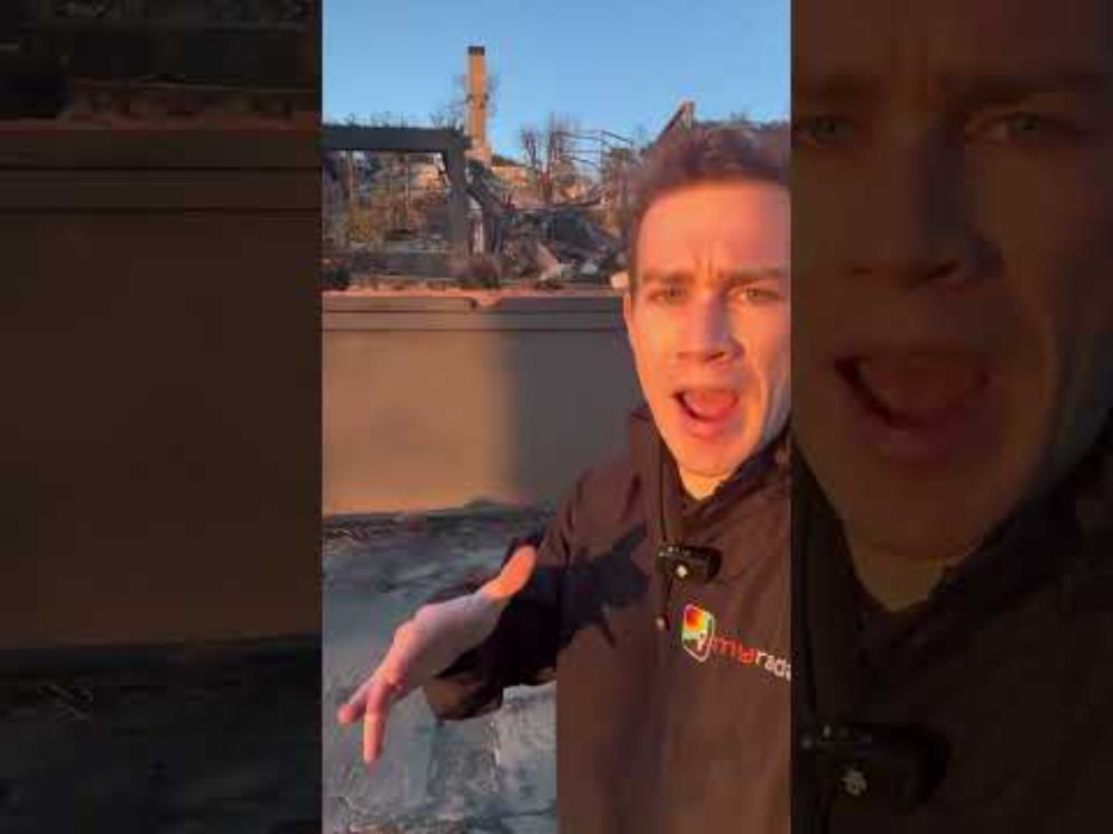
The INSANE Energy of the Palisades Fire 🔥
YouTube video by MyRadar Weather News
youtube.com
January 15, 2025 at 3:36 PM
The Palisades Fire burned more energy than the entire city of Los Angeles used in 2 years. That’s a LOT of heat release.
Meteorologist @matthewcappucci.bsky.social explains. #wildfires #palisadesfire #california #losangeles #fire
Meteorologist @matthewcappucci.bsky.social explains. #wildfires #palisadesfire #california #losangeles #fire
Reposted by Matthew Cappucci
The wheel covers of luxury cars are often made of aluminum. Aluminum melts at 1,221°F. Meteorologist @matthewcappucci.bsky.social believes the Palisades Fire burned at least 1,400° as it scorched neighborhoods — and likely much hotter. #fire #PalisadesFire #Eatonfire
January 14, 2025 at 7:42 PM
The wheel covers of luxury cars are often made of aluminum. Aluminum melts at 1,221°F. Meteorologist @matthewcappucci.bsky.social believes the Palisades Fire burned at least 1,400° as it scorched neighborhoods — and likely much hotter. #fire #PalisadesFire #Eatonfire