


Matthew Cappucci
@matthewcappucci.bsky.social
Senior meteorologist. MyRadar. Washington Post/NPR/TV too. Atmospheric scientist. Educational consultant. Harvard/MIT ‘19.
FOX35 just got hit by a tornado LIVE ON AIR! Tornado just passed Lake Mary and is heading toward Orlando’s Sanford International Airport!
March 10, 2025 at 1:52 PM
FOX35 just got hit by a tornado LIVE ON AIR! Tornado just passed Lake Mary and is heading toward Orlando’s Sanford International Airport!
There is a slight chance of a bit of #thundersnow in NYC as a bit of elevated instability, or thunderstorm fuel at the atmosphere’s mid levels, works through.
Plus the tall buildings are effective at focusing the diffuse lower positive charge found in snow clouds. @myradar.bsky.social
Plus the tall buildings are effective at focusing the diffuse lower positive charge found in snow clouds. @myradar.bsky.social
February 6, 2025 at 2:57 AM
There is a slight chance of a bit of #thundersnow in NYC as a bit of elevated instability, or thunderstorm fuel at the atmosphere’s mid levels, works through.
Plus the tall buildings are effective at focusing the diffuse lower positive charge found in snow clouds. @myradar.bsky.social
Plus the tall buildings are effective at focusing the diffuse lower positive charge found in snow clouds. @myradar.bsky.social
A thump of heavy snow will move along I-95 tomorrow morning between NYC and Boston.
Why? Frontogenesis.
Changing temperatures make a density ramp in the atmosphere that moisture rises up. That moisture comes back down as heavy snow. @myradar.bsky.social
Why? Frontogenesis.
Changing temperatures make a density ramp in the atmosphere that moisture rises up. That moisture comes back down as heavy snow. @myradar.bsky.social
February 6, 2025 at 2:49 AM
A thump of heavy snow will move along I-95 tomorrow morning between NYC and Boston.
Why? Frontogenesis.
Changing temperatures make a density ramp in the atmosphere that moisture rises up. That moisture comes back down as heavy snow. @myradar.bsky.social
Why? Frontogenesis.
Changing temperatures make a density ramp in the atmosphere that moisture rises up. That moisture comes back down as heavy snow. @myradar.bsky.social
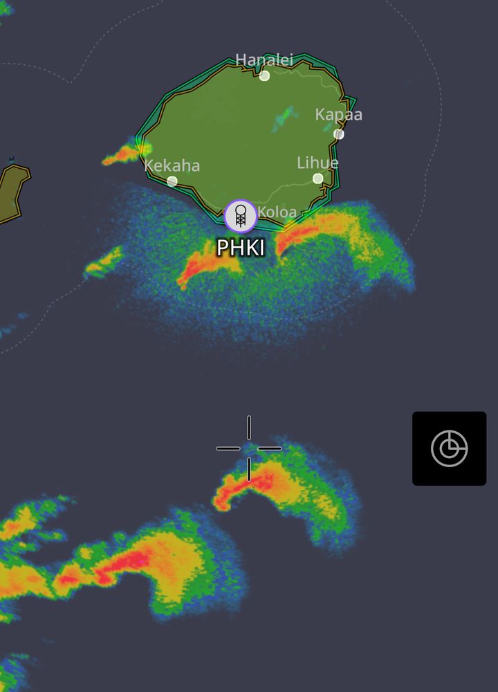
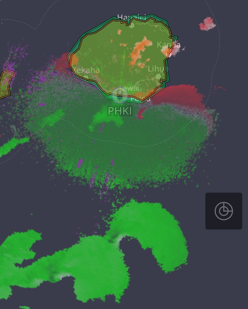
Supercell outbreak in HAWAII! These rotating supercells are producing tornadic waterspouts.
Tornadoes are possible, particularly near Kauai in the next few hours. Track the latest in the @myradar.bsky.social app.
Tornadoes are possible, particularly near Kauai in the next few hours. Track the latest in the @myradar.bsky.social app.
January 30, 2025 at 4:48 PM
Supercell outbreak in HAWAII! These rotating supercells are producing tornadic waterspouts.
Tornadoes are possible, particularly near Kauai in the next few hours. Track the latest in the @myradar.bsky.social app.
Tornadoes are possible, particularly near Kauai in the next few hours. Track the latest in the @myradar.bsky.social app.
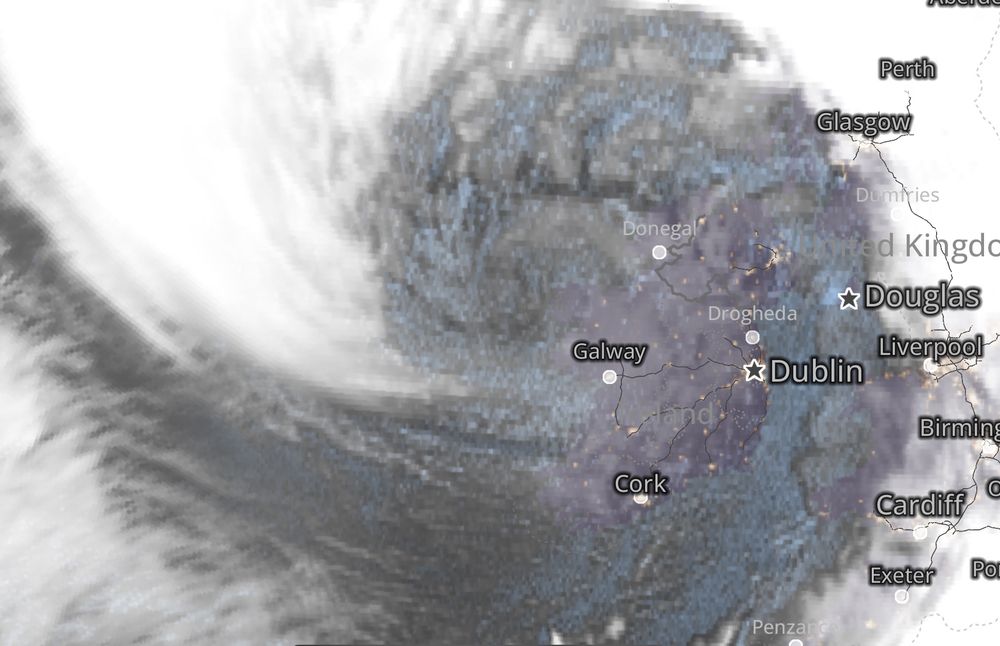
WOW! The sting jet is about to hit Galway! See the pointy cloud? That’s the “stinger” as seen in @myradar.bsky.social!
Shannon Airport has already gusted to 78 mph; Dublin has gusted to 60 mph.
Galway should be ready for winds gusting 90-100 mph over the next few hours. #StormEowyn
Shannon Airport has already gusted to 78 mph; Dublin has gusted to 60 mph.
Galway should be ready for winds gusting 90-100 mph over the next few hours. #StormEowyn
January 24, 2025 at 4:16 AM
WOW! The sting jet is about to hit Galway! See the pointy cloud? That’s the “stinger” as seen in @myradar.bsky.social!
Shannon Airport has already gusted to 78 mph; Dublin has gusted to 60 mph.
Galway should be ready for winds gusting 90-100 mph over the next few hours. #StormEowyn
Shannon Airport has already gusted to 78 mph; Dublin has gusted to 60 mph.
Galway should be ready for winds gusting 90-100 mph over the next few hours. #StormEowyn
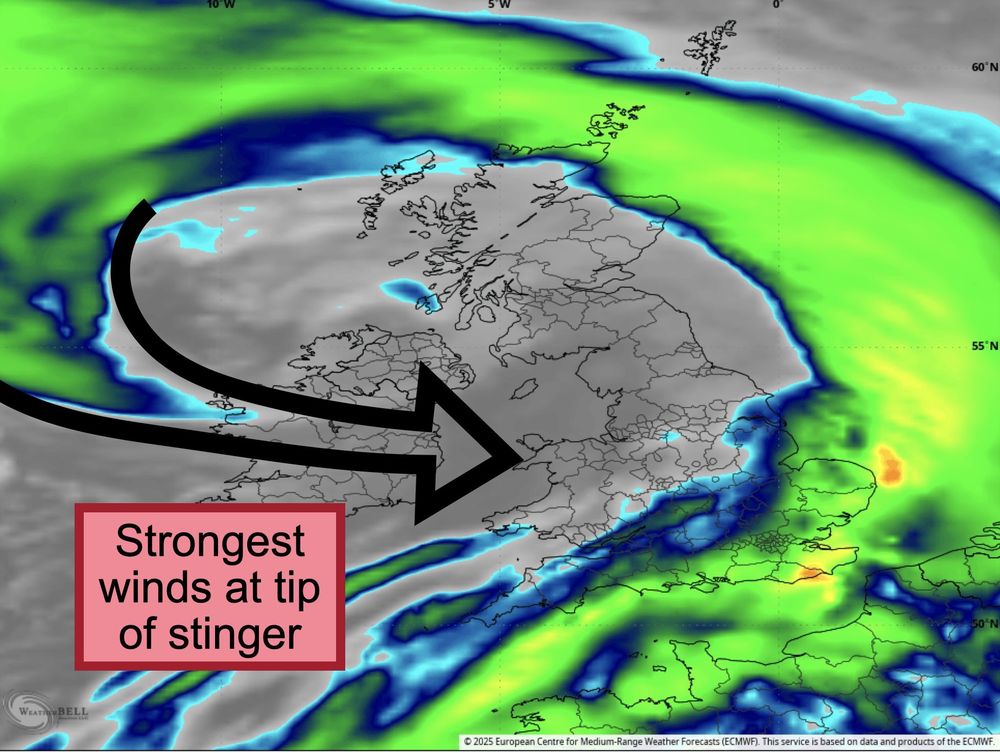
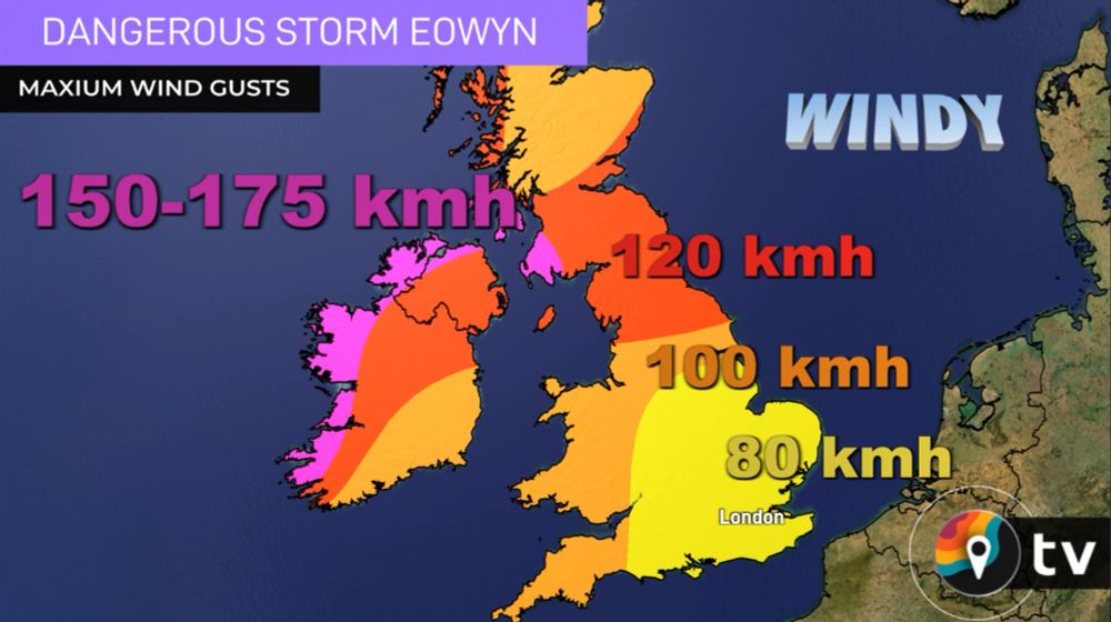
Tonight will feature dangerously strong winds in Ireland, with gusts over 100 mph at the coastline as a "sting jet" descends to the ground.
Much of the United Kingdom will face winds approaching hurricane force.
Plan for damage and power outages. @myradar.bsky.social update coming.
Much of the United Kingdom will face winds approaching hurricane force.
Plan for damage and power outages. @myradar.bsky.social update coming.
January 23, 2025 at 5:51 PM
Tonight will feature dangerously strong winds in Ireland, with gusts over 100 mph at the coastline as a "sting jet" descends to the ground.
Much of the United Kingdom will face winds approaching hurricane force.
Plan for damage and power outages. @myradar.bsky.social update coming.
Much of the United Kingdom will face winds approaching hurricane force.
Plan for damage and power outages. @myradar.bsky.social update coming.
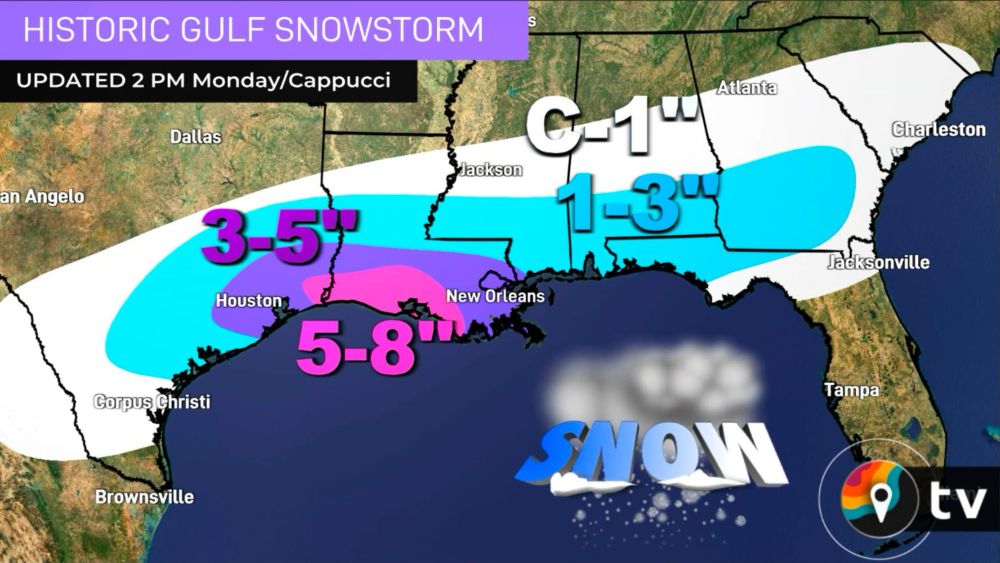
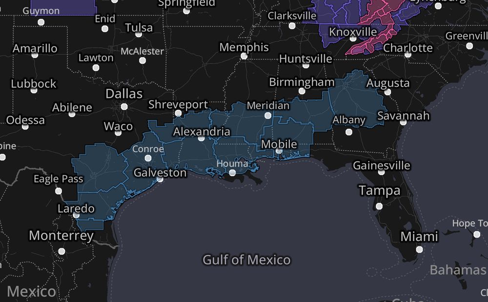
A historic winter storm, complete with half a foot of snow in the Louisiana bayous, is shaping up for the Gulf Coast.
Winter storm warnings span from the Mexican border to coastal Georgia.
Snow will cover palm trees.🌴This is rare and exceptional.
Winter storm warnings span from the Mexican border to coastal Georgia.
Snow will cover palm trees.🌴This is rare and exceptional.
January 20, 2025 at 11:39 PM
A historic winter storm, complete with half a foot of snow in the Louisiana bayous, is shaping up for the Gulf Coast.
Winter storm warnings span from the Mexican border to coastal Georgia.
Snow will cover palm trees.🌴This is rare and exceptional.
Winter storm warnings span from the Mexican border to coastal Georgia.
Snow will cover palm trees.🌴This is rare and exceptional.
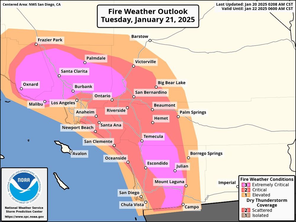
PDS — or Particularly Dangerous Situation — red flag warning for Los Angeles and Ventura Counties.
HUGE danger if any new fires crop up. This danger will continue, potentially with disastrous results, until widespread rain arrives in Southern California.
HUGE danger if any new fires crop up. This danger will continue, potentially with disastrous results, until widespread rain arrives in Southern California.
January 20, 2025 at 11:39 PM
PDS — or Particularly Dangerous Situation — red flag warning for Los Angeles and Ventura Counties.
HUGE danger if any new fires crop up. This danger will continue, potentially with disastrous results, until widespread rain arrives in Southern California.
HUGE danger if any new fires crop up. This danger will continue, potentially with disastrous results, until widespread rain arrives in Southern California.
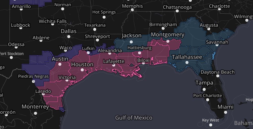
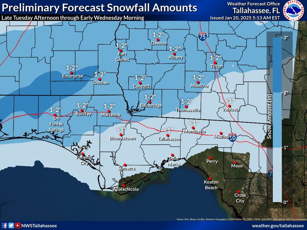
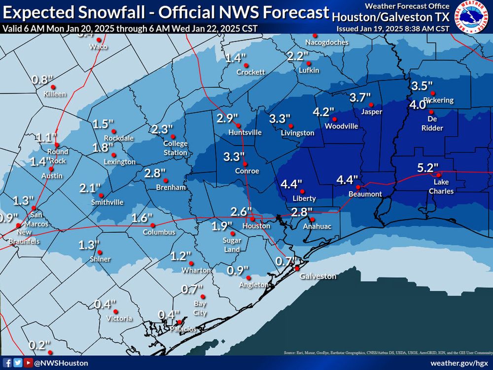
An absolutely historic winter storm is in the cards for the Gulf Coast!
Winter storm warnings stretch from the Mexican border to the Florida Panhandle. Widespread 2-4” totals are likely, including in Houston and New Orleans
.
Panama City might even see an inch or two!
WOW. ❄️
Winter storm warnings stretch from the Mexican border to the Florida Panhandle. Widespread 2-4” totals are likely, including in Houston and New Orleans
.
Panama City might even see an inch or two!
WOW. ❄️
January 20, 2025 at 6:02 PM
An absolutely historic winter storm is in the cards for the Gulf Coast!
Winter storm warnings stretch from the Mexican border to the Florida Panhandle. Widespread 2-4” totals are likely, including in Houston and New Orleans
.
Panama City might even see an inch or two!
WOW. ❄️
Winter storm warnings stretch from the Mexican border to the Florida Panhandle. Widespread 2-4” totals are likely, including in Houston and New Orleans
.
Panama City might even see an inch or two!
WOW. ❄️
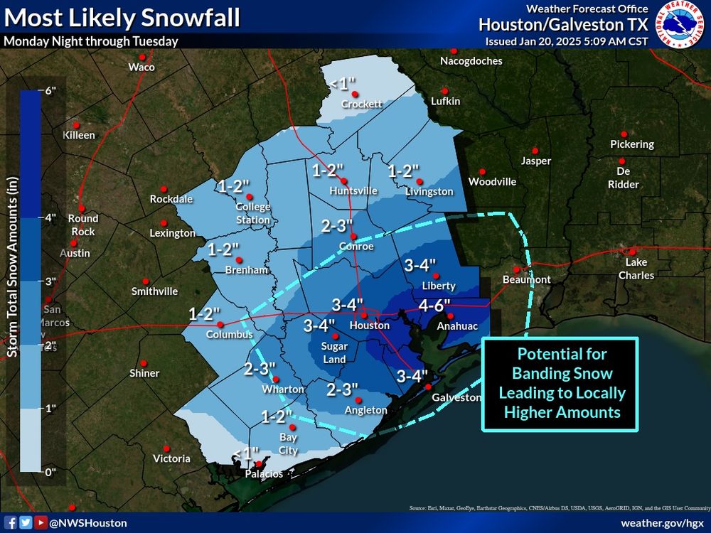
WOW! Winter storm for the Gulf Coast!
Winter storm watches stretch from the Mexican border to Atlanta.
Houston will see 2-4 inches of snow. So will New Orleans! Even snow on the TX Barriwr Islands!
A rare, significant winter storm for places where palm trees are ubiquitous! 🌴
Winter storm watches stretch from the Mexican border to Atlanta.
Houston will see 2-4 inches of snow. So will New Orleans! Even snow on the TX Barriwr Islands!
A rare, significant winter storm for places where palm trees are ubiquitous! 🌴
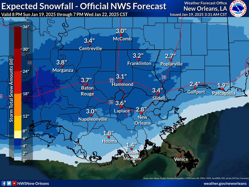
January 19, 2025 at 3:02 PM
WOW! Winter storm for the Gulf Coast!
Winter storm watches stretch from the Mexican border to Atlanta.
Houston will see 2-4 inches of snow. So will New Orleans! Even snow on the TX Barriwr Islands!
A rare, significant winter storm for places where palm trees are ubiquitous! 🌴
Winter storm watches stretch from the Mexican border to Atlanta.
Houston will see 2-4 inches of snow. So will New Orleans! Even snow on the TX Barriwr Islands!
A rare, significant winter storm for places where palm trees are ubiquitous! 🌴
If you live in Los Angeles, shut your windows and turn off your vents to the outside — the air quality is hazardous.
You can visualize air quality in the @myradar.bsky.social map. The bull’s eye of hazardous air is directly over the nation’s second-largest city.
You can visualize air quality in the @myradar.bsky.social map. The bull’s eye of hazardous air is directly over the nation’s second-largest city.
January 8, 2025 at 7:23 PM
If you live in Los Angeles, shut your windows and turn off your vents to the outside — the air quality is hazardous.
You can visualize air quality in the @myradar.bsky.social map. The bull’s eye of hazardous air is directly over the nation’s second-largest city.
You can visualize air quality in the @myradar.bsky.social map. The bull’s eye of hazardous air is directly over the nation’s second-largest city.
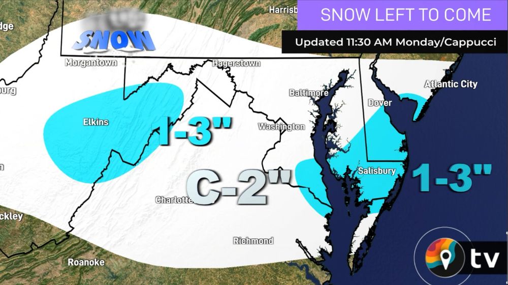
DMV folks – here's how much MORE snow is on the way this evening with the "backlash," or the cold air wraparound:
January 6, 2025 at 5:41 PM
DMV folks – here's how much MORE snow is on the way this evening with the "backlash," or the cold air wraparound:
10 PM update – made a few very minor tweaks:
- added a 9-12" contour for parts of the Delmarva
- nudged the 6-10" contour a bit north into northern Howard/Anne Arundel Counties toward Baltimore
- brought the 4-7" contour toward the Mason-Dixon Line
– Kept southern edges as is
- added a 9-12" contour for parts of the Delmarva
- nudged the 6-10" contour a bit north into northern Howard/Anne Arundel Counties toward Baltimore
- brought the 4-7" contour toward the Mason-Dixon Line
– Kept southern edges as is

January 6, 2025 at 3:15 AM
10 PM update – made a few very minor tweaks:
- added a 9-12" contour for parts of the Delmarva
- nudged the 6-10" contour a bit north into northern Howard/Anne Arundel Counties toward Baltimore
- brought the 4-7" contour toward the Mason-Dixon Line
– Kept southern edges as is
- added a 9-12" contour for parts of the Delmarva
- nudged the 6-10" contour a bit north into northern Howard/Anne Arundel Counties toward Baltimore
- brought the 4-7" contour toward the Mason-Dixon Line
– Kept southern edges as is
But wait – there's more! (Maybe.)
There are indications that another storm system may develop over Texas on Thursday IF two disturbances "phase," or overlap synergistically.
That would introduce the possibility of another East Coast storm.
Low risk, but monitoring.
There are indications that another storm system may develop over Texas on Thursday IF two disturbances "phase," or overlap synergistically.
That would introduce the possibility of another East Coast storm.
Low risk, but monitoring.

January 6, 2025 at 12:16 AM
But wait – there's more! (Maybe.)
There are indications that another storm system may develop over Texas on Thursday IF two disturbances "phase," or overlap synergistically.
That would introduce the possibility of another East Coast storm.
Low risk, but monitoring.
There are indications that another storm system may develop over Texas on Thursday IF two disturbances "phase," or overlap synergistically.
That would introduce the possibility of another East Coast storm.
Low risk, but monitoring.
Icing is mainly south of I-66, but could be a concern for Interstate 81 and especially folks in West Virginia.

January 5, 2025 at 2:32 PM
Icing is mainly south of I-66, but could be a concern for Interstate 81 and especially folks in West Virginia.
Keep in mind this will be heavy, wet snow... perfect for snowballs (cough cough @dcsnowball) that will be tough to shovel.
(Heart attacks are common following big winter storms. Please take it easy if you're shoveling.)
(Heart attacks are common following big winter storms. Please take it easy if you're shoveling.)

January 5, 2025 at 2:21 PM
Keep in mind this will be heavy, wet snow... perfect for snowballs (cough cough @dcsnowball) that will be tough to shovel.
(Heart attacks are common following big winter storms. Please take it easy if you're shoveling.)
(Heart attacks are common following big winter storms. Please take it easy if you're shoveling.)
While we've all been focused on the big synoptic-scale winter storm, let's not forget that the Tug Hill Plateau just got another 5 FEET of snow from the Lake Ontario lake-effect band.
East Camden is up to 65 inches; 64 in Westernville, N.Y.
East Camden is up to 65 inches; 64 in Westernville, N.Y.

January 5, 2025 at 1:41 PM
While we've all been focused on the big synoptic-scale winter storm, let's not forget that the Tug Hill Plateau just got another 5 FEET of snow from the Lake Ontario lake-effect band.
East Camden is up to 65 inches; 64 in Westernville, N.Y.
East Camden is up to 65 inches; 64 in Westernville, N.Y.
DMV gang – we're finally within range of the HRRR, or our highest-resolution computer model. I like the progression of this.
I think D.C. gets almost entirely snow this time around, with only a brief mix or freezing rein during the early evening hours Monday.
I think D.C. gets almost entirely snow this time around, with only a brief mix or freezing rein during the early evening hours Monday.
January 5, 2025 at 2:03 AM
DMV gang – we're finally within range of the HRRR, or our highest-resolution computer model. I like the progression of this.
I think D.C. gets almost entirely snow this time around, with only a brief mix or freezing rein during the early evening hours Monday.
I think D.C. gets almost entirely snow this time around, with only a brief mix or freezing rein during the early evening hours Monday.
DMV folks – here's my Saturday night SNOWSTORM update!
Still looking like D.C. will be in the belt of heaviest snow... 5 to 10 inches, but localized 12 inches can't be ruled out across the DMV. We'll likely stay just north of the rain/snow line.
Next to no adjustments:
Still looking like D.C. will be in the belt of heaviest snow... 5 to 10 inches, but localized 12 inches can't be ruled out across the DMV. We'll likely stay just north of the rain/snow line.
Next to no adjustments:

January 5, 2025 at 1:46 AM
DMV folks – here's my Saturday night SNOWSTORM update!
Still looking like D.C. will be in the belt of heaviest snow... 5 to 10 inches, but localized 12 inches can't be ruled out across the DMV. We'll likely stay just north of the rain/snow line.
Next to no adjustments:
Still looking like D.C. will be in the belt of heaviest snow... 5 to 10 inches, but localized 12 inches can't be ruled out across the DMV. We'll likely stay just north of the rain/snow line.
Next to no adjustments:
Alrighty gang! We have winter storm warnings now in the pink.
6 to 8 inches of snow in Washington D.C., with up to a foot in the higher terrain of the Alleghenies.
Some mixing and ice accretion in southwest Virginia.
6 to 8 inches of snow in Washington D.C., with up to a foot in the higher terrain of the Alleghenies.
Some mixing and ice accretion in southwest Virginia.

January 4, 2025 at 11:51 PM
Alrighty gang! We have winter storm warnings now in the pink.
6 to 8 inches of snow in Washington D.C., with up to a foot in the higher terrain of the Alleghenies.
Some mixing and ice accretion in southwest Virginia.
6 to 8 inches of snow in Washington D.C., with up to a foot in the higher terrain of the Alleghenies.
Some mixing and ice accretion in southwest Virginia.
HERE WE GO! Snowstorm time for the DMV. Here's my latest thinking.
Snow begins Sunday night. It thumps during the morning, may briefly mix with sleet or freezing rain south of town, then becomes all snow again for everyone Monday evening with a surge of cold air on the back.
Snow begins Sunday night. It thumps during the morning, may briefly mix with sleet or freezing rain south of town, then becomes all snow again for everyone Monday evening with a surge of cold air on the back.

January 4, 2025 at 1:02 PM
HERE WE GO! Snowstorm time for the DMV. Here's my latest thinking.
Snow begins Sunday night. It thumps during the morning, may briefly mix with sleet or freezing rain south of town, then becomes all snow again for everyone Monday evening with a surge of cold air on the back.
Snow begins Sunday night. It thumps during the morning, may briefly mix with sleet or freezing rain south of town, then becomes all snow again for everyone Monday evening with a surge of cold air on the back.
Thundersnow!? ⚡️ Today's environment is ripe for it! We've got some instability (thunderstorm fuel) and weather models are also simulating some lightning activity!


January 3, 2025 at 1:44 PM
Thundersnow!? ⚡️ Today's environment is ripe for it! We've got some instability (thunderstorm fuel) and weather models are also simulating some lightning activity!
Alright DMV gang! Here it is – my first stab snow map for Monday's storm. ❄️
NOTE: A LOT can change. As for now, the heaviest looks to be between D.C. and the Mason-Dixon Line.
In southwest portions of our area, I'm expecting mixing with some sleet/freezing rain. @myradar.bsky.social
NOTE: A LOT can change. As for now, the heaviest looks to be between D.C. and the Mason-Dixon Line.
In southwest portions of our area, I'm expecting mixing with some sleet/freezing rain. @myradar.bsky.social

January 3, 2025 at 1:07 PM
Alright DMV gang! Here it is – my first stab snow map for Monday's storm. ❄️
NOTE: A LOT can change. As for now, the heaviest looks to be between D.C. and the Mason-Dixon Line.
In southwest portions of our area, I'm expecting mixing with some sleet/freezing rain. @myradar.bsky.social
NOTE: A LOT can change. As for now, the heaviest looks to be between D.C. and the Mason-Dixon Line.
In southwest portions of our area, I'm expecting mixing with some sleet/freezing rain. @myradar.bsky.social
This is going to be a BIG headache for a lot of people.
Some folks see a foot of snow... others see a serious ice storm.
We'll have a full update out this afternoon in the @MyRadarWX app.
Some folks see a foot of snow... others see a serious ice storm.
We'll have a full update out this afternoon in the @MyRadarWX app.

January 2, 2025 at 6:54 PM
This is going to be a BIG headache for a lot of people.
Some folks see a foot of snow... others see a serious ice storm.
We'll have a full update out this afternoon in the @MyRadarWX app.
Some folks see a foot of snow... others see a serious ice storm.
We'll have a full update out this afternoon in the @MyRadarWX app.
MONDAY snow in the DMV:
The chance of accumulating snow Sunday night into Monday night is INCREASING for the DMV.
A low pressure system will pass nearby. If it passes just a bit south, we're on the cold side. About a 40% chance of plowable snowfall.
Ironing out details.
The chance of accumulating snow Sunday night into Monday night is INCREASING for the DMV.
A low pressure system will pass nearby. If it passes just a bit south, we're on the cold side. About a 40% chance of plowable snowfall.
Ironing out details.
January 2, 2025 at 12:21 PM
MONDAY snow in the DMV:
The chance of accumulating snow Sunday night into Monday night is INCREASING for the DMV.
A low pressure system will pass nearby. If it passes just a bit south, we're on the cold side. About a 40% chance of plowable snowfall.
Ironing out details.
The chance of accumulating snow Sunday night into Monday night is INCREASING for the DMV.
A low pressure system will pass nearby. If it passes just a bit south, we're on the cold side. About a 40% chance of plowable snowfall.
Ironing out details.