


Reposted by Mark Miller

WPC has initiated Key Messages for an impending coastal storm that will look to generate strong wind gusts, heavy rainfall, and significant coastal impacts that include coastal flooding, rip currents, and beach erosion along portions of the East Coast over the upcoming weekend.

October 8, 2025 at 6:13 PM
WPC has initiated Key Messages for an impending coastal storm that will look to generate strong wind gusts, heavy rainfall, and significant coastal impacts that include coastal flooding, rip currents, and beach erosion along portions of the East Coast over the upcoming weekend.
Reposted by Mark Miller

Highly unusual situation approaching western Colorado with the moisture from Hurricane Priscilla. Grand Junction has never had precipitable water over an inch (25mm) so late in the year, but looks like it will be near that level on both Fri & Sat. Six standard deviations above average! #cowx 1/2


October 8, 2025 at 2:23 PM
Highly unusual situation approaching western Colorado with the moisture from Hurricane Priscilla. Grand Junction has never had precipitable water over an inch (25mm) so late in the year, but looks like it will be near that level on both Fri & Sat. Six standard deviations above average! #cowx 1/2
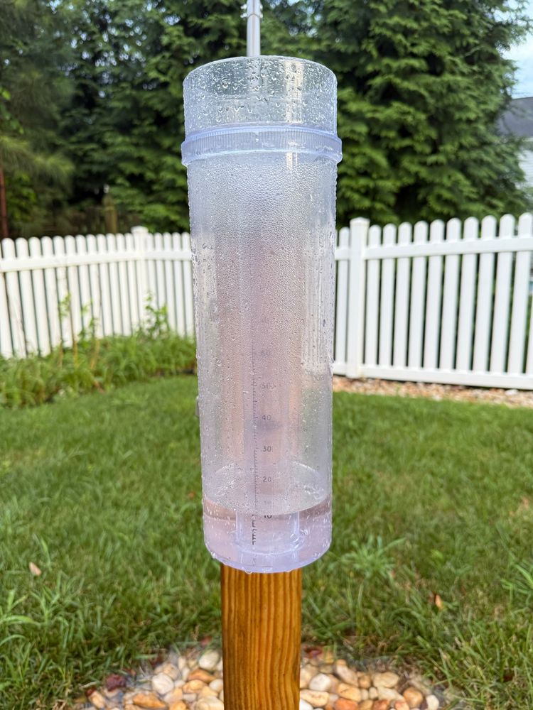
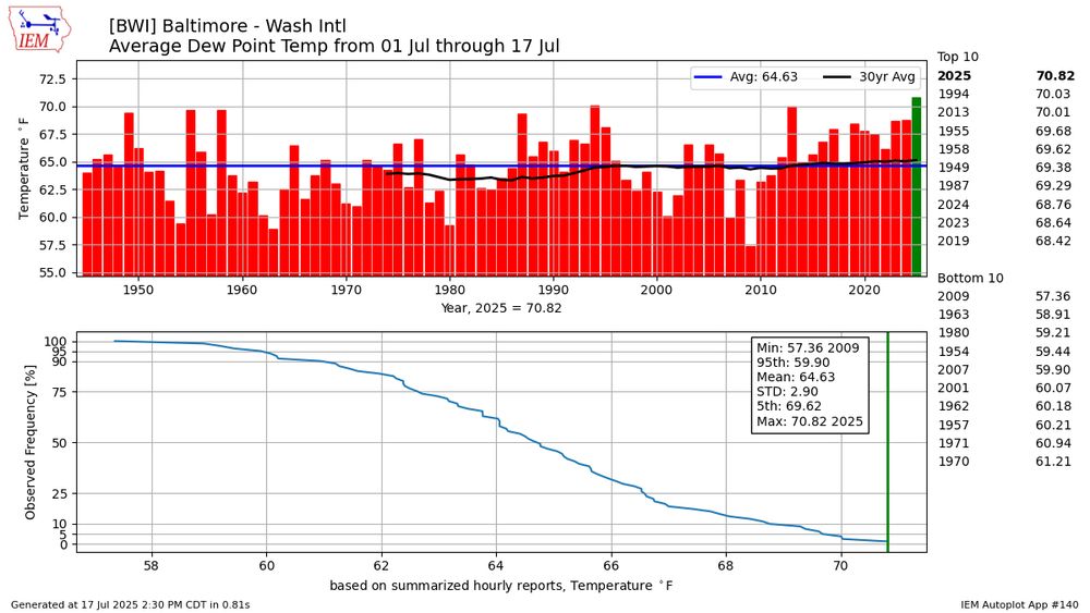
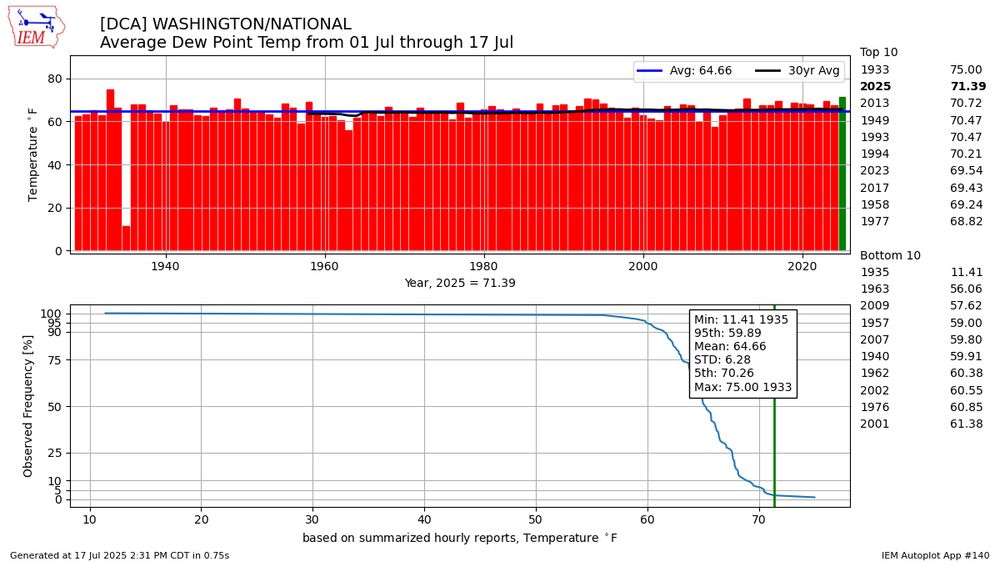
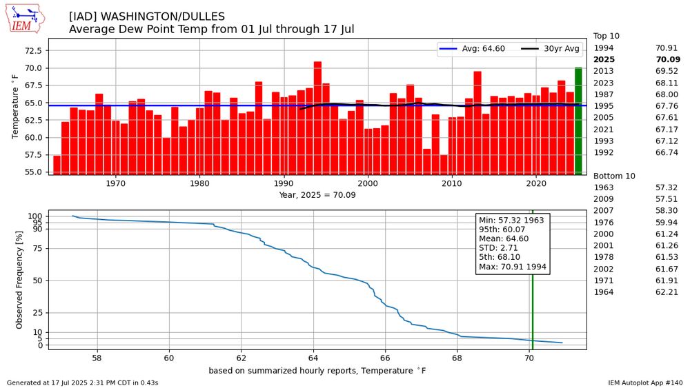
Think it’s been especially humid in the DMV lately? You’d be right. Avg dew point (computed by averaging daily max/min dew point) at the three major climate sites (BWI/DCA/IAD) for July 2025 thru today all top 2 on record, and BWI is #1. Yuck. Made via mesonet.agron.iastate.edu/plotting/auto/ # 140
July 17, 2025 at 11:36 PM
Think it’s been especially humid in the DMV lately? You’d be right. Avg dew point (computed by averaging daily max/min dew point) at the three major climate sites (BWI/DCA/IAD) for July 2025 thru today all top 2 on record, and BWI is #1. Yuck. Made via mesonet.agron.iastate.edu/plotting/auto/ # 140
Reposted by Mark Miller

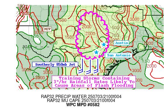
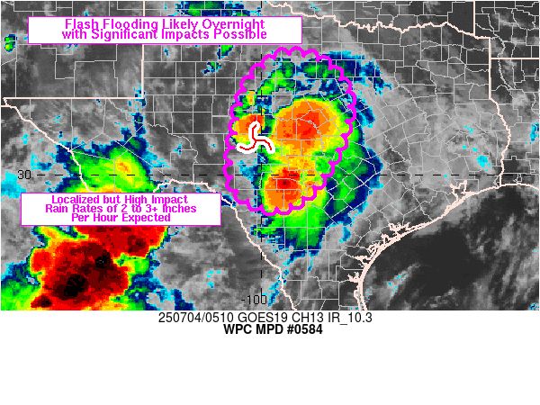
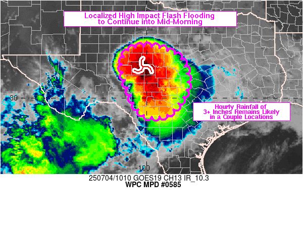
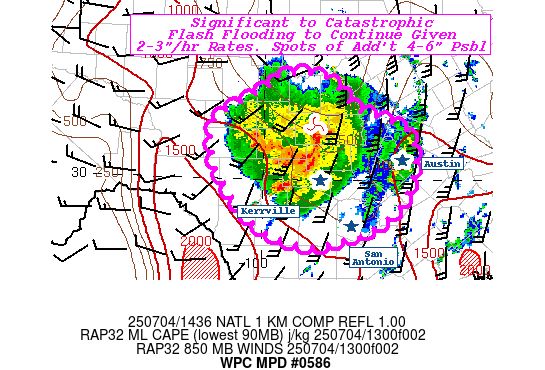
WPC issued as many as six MPDs for the deadly flash flooding in the TX Hill Country starting yesterday evening and lasting through much of today. The first MPD generally set the stage for what was to come, while the next three shown were as the event unfolded.
July 5, 2025 at 12:03 AM
WPC issued as many as six MPDs for the deadly flash flooding in the TX Hill Country starting yesterday evening and lasting through much of today. The first MPD generally set the stage for what was to come, while the next three shown were as the event unfolded.
Reposted by Mark Miller
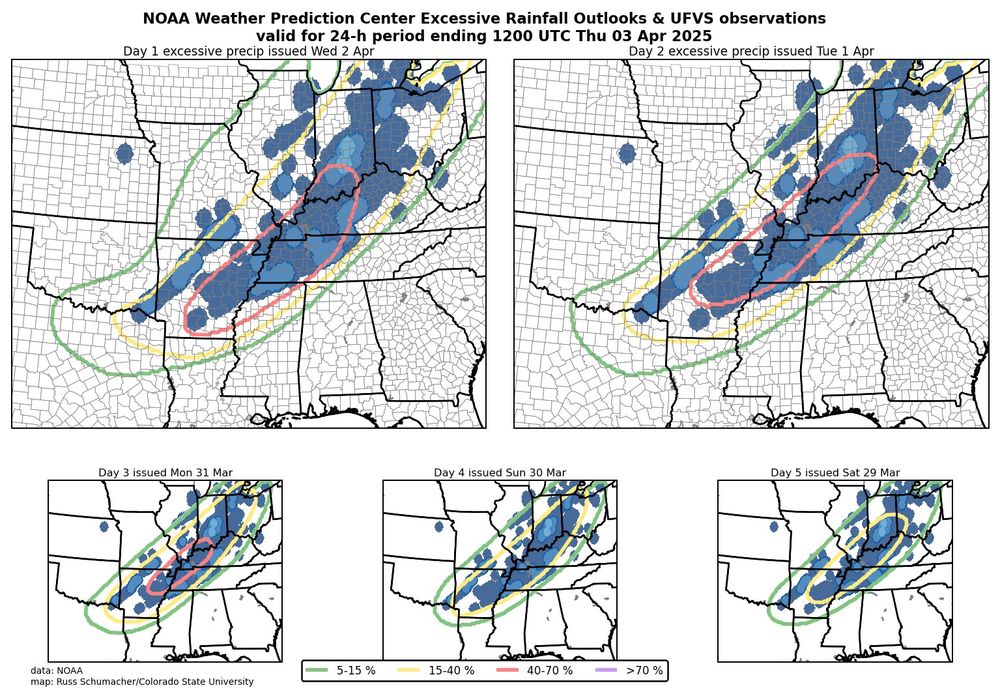
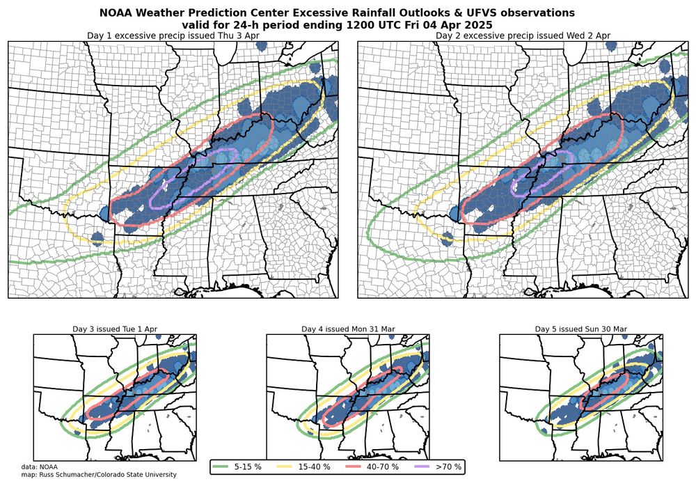
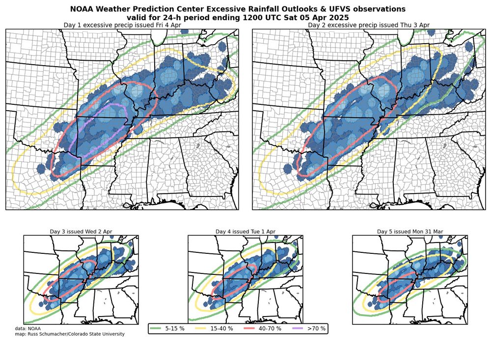
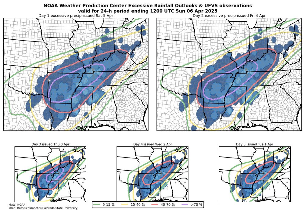
We often (rightly) see maps like these showing how good SPC convective outlooks are; let's also give some kudos to WPC for some outstanding excessive rainfall outlooks for this event. Especially impressive are the day 5 outlooks, giving advance notice of prolonged excessive rainfall and flood risk.
April 6, 2025 at 10:00 PM
We often (rightly) see maps like these showing how good SPC convective outlooks are; let's also give some kudos to WPC for some outstanding excessive rainfall outlooks for this event. Especially impressive are the day 5 outlooks, giving advance notice of prolonged excessive rainfall and flood risk.