
Maude Williams
@mafawi.bsky.social
Historienne | HGIS | digital public history | 🇧🇪🇩🇪🇫🇷|
Neues zum Thema Populärmusik transnational in den langen 1960er Jahren!

April 11, 2025 at 7:59 AM
Neues zum Thema Populärmusik transnational in den langen 1960er Jahren!
Reposted by Maude Williams
Reposted by Maude Williams
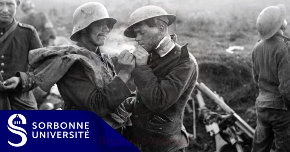
💬 "Ils entendent les soldats de l’autre côté du no man’s land parler, rire, pleurer... Pourtant ennemis, ils se trouvent des points communs." (@mafawi.bsky.social)
🔴 Ressource pédagogique (lycée - #Histoire - Première) 👇
ehne.fr/fr/eduscol/p...
🤝 @aphg.bsky.social @lettres-sorbonne.bsky.social
🔴 Ressource pédagogique (lycée - #Histoire - Première) 👇
ehne.fr/fr/eduscol/p...
🤝 @aphg.bsky.social @lettres-sorbonne.bsky.social

Fraternisations aux armées pendant les deux guerres mondiales
ehne.fr
March 28, 2025 at 7:45 AM
💬 "Ils entendent les soldats de l’autre côté du no man’s land parler, rire, pleurer... Pourtant ennemis, ils se trouvent des points communs." (@mafawi.bsky.social)
🔴 Ressource pédagogique (lycée - #Histoire - Première) 👇
ehne.fr/fr/eduscol/p...
🤝 @aphg.bsky.social @lettres-sorbonne.bsky.social
🔴 Ressource pédagogique (lycée - #Histoire - Première) 👇
ehne.fr/fr/eduscol/p...
🤝 @aphg.bsky.social @lettres-sorbonne.bsky.social
Reposted by Maude Williams
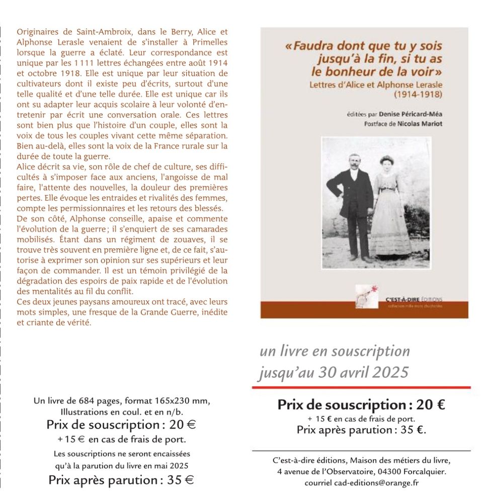
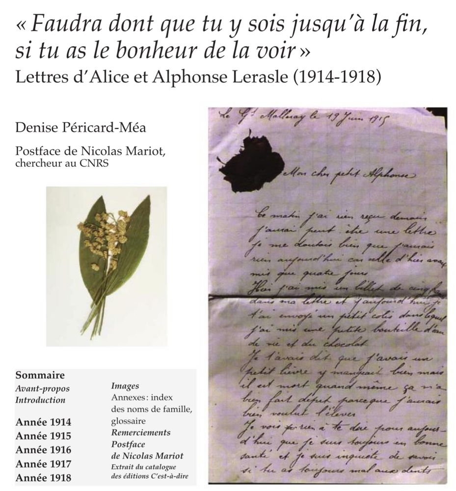
Un beau projet éditorial 1e GM qui pourra voir le jour via cette souscription : correspondance d’un couple paysan dans la guerre, un type de document en réalité très rare (alors qu’ils furent le groupe majoritaire au front comme à l’arrière). Postface de Nicolas Mariot.
À partager et diffuser !
À partager et diffuser !
March 25, 2025 at 6:09 PM
Un beau projet éditorial 1e GM qui pourra voir le jour via cette souscription : correspondance d’un couple paysan dans la guerre, un type de document en réalité très rare (alors qu’ils furent le groupe majoritaire au front comme à l’arrière). Postface de Nicolas Mariot.
À partager et diffuser !
À partager et diffuser !
Reposted by Maude Williams
We have updated the list (with links) of public history courses and programmes around the world. We will have courses in green, programmes in red and labs in blue. www.google.com/maps/d/edit?... #PublicHistory @ncph.bsky.social

Public History Courses, Programmes, Projects - Google My Maps
List of University Public History Centers, Programmes and project. If you want to add your projects, courses... send an email to Thomas.cauvin@uni.lu Please send the title, a location, and a URL (link...
www.google.com
March 11, 2025 at 10:59 AM
We have updated the list (with links) of public history courses and programmes around the world. We will have courses in green, programmes in red and labs in blue. www.google.com/maps/d/edit?... #PublicHistory @ncph.bsky.social
Reposted by Maude Williams
💬 "Jusqu’à la Première Guerre mondiale, l’improvisation dictait la propagande au front. Par la suite, cette pratique s’institutionnalise." (@mafawi.bsky.social)
🔴 Ressource pédagogique pour le lycée (Première – #HGGSP)
🤝 @aphg.bsky.social @lettres-sorbonne.bsky.social
ehne.fr/fr/encyclope...
🔴 Ressource pédagogique pour le lycée (Première – #HGGSP)
🤝 @aphg.bsky.social @lettres-sorbonne.bsky.social
ehne.fr/fr/encyclope...
De la propagande au front au front de propagande
ehne.fr
February 10, 2025 at 12:35 PM
💬 "Jusqu’à la Première Guerre mondiale, l’improvisation dictait la propagande au front. Par la suite, cette pratique s’institutionnalise." (@mafawi.bsky.social)
🔴 Ressource pédagogique pour le lycée (Première – #HGGSP)
🤝 @aphg.bsky.social @lettres-sorbonne.bsky.social
ehne.fr/fr/encyclope...
🔴 Ressource pédagogique pour le lycée (Première – #HGGSP)
🤝 @aphg.bsky.social @lettres-sorbonne.bsky.social
ehne.fr/fr/encyclope...
Reposted by Maude Williams

🎮 What about playing with a #PhD thesis?
Find the ananachronisms in the #19thcentury reconstruction of 'Vieux Paris' in the videogame based on @elisa-chazal.bsky.social 's doctoral research 👇
🎮 #DigitalHistory #skystorians #VisualHistory
Find the ananachronisms in the #19thcentury reconstruction of 'Vieux Paris' in the videogame based on @elisa-chazal.bsky.social 's doctoral research 👇
🎮 #DigitalHistory #skystorians #VisualHistory

My wonderful colleague @elisa-chazal.bsky.social has turned parts of her doctoral research into a video game 🎮
Find out more about anachronisms in the 19th-century reconstruction of 'Vieux Paris' and the team behind the game 👇
dawnfj.itch.io/les-chroniqu...
Find out more about anachronisms in the 19th-century reconstruction of 'Vieux Paris' and the team behind the game 👇
dawnfj.itch.io/les-chroniqu...

Les Chroniques d'Ana by Florent, Kounine, Vincent BONNET 3d, ogadaki, Leuha, Solenn.R
Une journaliste explore une reconstitution historique du XVe siècle lors de l'exposition universelle de Paris 1900.
dawnfj.itch.io
January 31, 2025 at 2:44 PM
🎮 What about playing with a #PhD thesis?
Find the ananachronisms in the #19thcentury reconstruction of 'Vieux Paris' in the videogame based on @elisa-chazal.bsky.social 's doctoral research 👇
🎮 #DigitalHistory #skystorians #VisualHistory
Find the ananachronisms in the #19thcentury reconstruction of 'Vieux Paris' in the videogame based on @elisa-chazal.bsky.social 's doctoral research 👇
🎮 #DigitalHistory #skystorians #VisualHistory
Reposted by Maude Williams

👋On this #InternationalDayOfHumanFraternity, discover the #history of fraternization in armed forces during the world wars.
An article ✍️by historian Maude Williams.
(@mafawi.bsky.social - @uni-saarland.de )
#warstudies #worldwars #fraternization #soldiers
👉 ehne.fr/en/encyclope...
An article ✍️by historian Maude Williams.
(@mafawi.bsky.social - @uni-saarland.de )
#warstudies #worldwars #fraternization #soldiers
👉 ehne.fr/en/encyclope...
Fraternization in the Armed Forces during the two World Wars.
Fraternization in the Armed Forces during the two World Wars.
ehne.fr
February 4, 2025 at 12:05 PM
👋On this #InternationalDayOfHumanFraternity, discover the #history of fraternization in armed forces during the world wars.
An article ✍️by historian Maude Williams.
(@mafawi.bsky.social - @uni-saarland.de )
#warstudies #worldwars #fraternization #soldiers
👉 ehne.fr/en/encyclope...
An article ✍️by historian Maude Williams.
(@mafawi.bsky.social - @uni-saarland.de )
#warstudies #worldwars #fraternization #soldiers
👉 ehne.fr/en/encyclope...
Reposted by Maude Williams
🚨Full Open Access 🚨 "Key Terms of Public History"
A @c2dh.uni.lu book series with @degruyterbrill.bsky.social
Edited by @cgpublichistory.bsky.social the book explores debates on authenticity, #heritage, #memory, emotion, and others.
#publichistory #history
www.degruyter.com/document/doi...
A @c2dh.uni.lu book series with @degruyterbrill.bsky.social
Edited by @cgpublichistory.bsky.social the book explores debates on authenticity, #heritage, #memory, emotion, and others.
#publichistory #history
www.degruyter.com/document/doi...

Key Terms of Public History
This volume introduces key terms of public history and makes them accessible via the most important subject areas and central research perspectives. It is aimed at students, teachers and practitioners...
www.degruyter.com
February 3, 2025 at 5:10 AM
🚨Full Open Access 🚨 "Key Terms of Public History"
A @c2dh.uni.lu book series with @degruyterbrill.bsky.social
Edited by @cgpublichistory.bsky.social the book explores debates on authenticity, #heritage, #memory, emotion, and others.
#publichistory #history
www.degruyter.com/document/doi...
A @c2dh.uni.lu book series with @degruyterbrill.bsky.social
Edited by @cgpublichistory.bsky.social the book explores debates on authenticity, #heritage, #memory, emotion, and others.
#publichistory #history
www.degruyter.com/document/doi...
Reposted by Maude Williams
Only 1 week left to submit your paper for the Day of Contemporary History in the Greater Region (25.04.2025) 📣
Scholars, early-career researchers,students, seize the opportunity to present innovative research, engage in critical discussions, and foster collaborations
👉 www.uni.lu/c2dh-en/news...
Scholars, early-career researchers,students, seize the opportunity to present innovative research, engage in critical discussions, and foster collaborations
👉 www.uni.lu/c2dh-en/news...

January 24, 2025 at 7:06 AM
Only 1 week left to submit your paper for the Day of Contemporary History in the Greater Region (25.04.2025) 📣
Scholars, early-career researchers,students, seize the opportunity to present innovative research, engage in critical discussions, and foster collaborations
👉 www.uni.lu/c2dh-en/news...
Scholars, early-career researchers,students, seize the opportunity to present innovative research, engage in critical discussions, and foster collaborations
👉 www.uni.lu/c2dh-en/news...
Reposted by Maude Williams
Remember the people who lived in Luxembourg before and during World War II and were persecuted by the Nazis. Follow their fate on memorialshoah.lu/en/
#HolocaustRemembranceDay #ww2
#HolocaustRemembranceDay #ww2

January 27, 2025 at 7:26 AM
Remember the people who lived in Luxembourg before and during World War II and were persecuted by the Nazis. Follow their fate on memorialshoah.lu/en/
#HolocaustRemembranceDay #ww2
#HolocaustRemembranceDay #ww2
Reposted by Maude Williams
More than 1.200 persons considered as Jews by the Nazis living in Luxembourg before the war were deported. Dive into this chapter of Luxembourg history with our digital exhibition 👉 ww2.lu 👈
#holocaustremembranceday #ww2
#holocaustremembranceday #ww2

January 27, 2025 at 11:32 AM
More than 1.200 persons considered as Jews by the Nazis living in Luxembourg before the war were deported. Dive into this chapter of Luxembourg history with our digital exhibition 👉 ww2.lu 👈
#holocaustremembranceday #ww2
#holocaustremembranceday #ww2
Reposted by Maude Williams

#Conférence
🔎🗺️ Ce 6 février à 18h15, assistez à la conférence @labnf.bsky.social "Expositions cartographiques et espaces urbains (Paris, XVIIIe-XXe siècle)" de Jean-Marc Besse, directeur d'études de l'EHESS @geographie-cites.bsky.social.
📍 5 rue Vivienne 75002 Paris
➡️ www.bnf.fr/fr/agenda/ex...
🔎🗺️ Ce 6 février à 18h15, assistez à la conférence @labnf.bsky.social "Expositions cartographiques et espaces urbains (Paris, XVIIIe-XXe siècle)" de Jean-Marc Besse, directeur d'études de l'EHESS @geographie-cites.bsky.social.
📍 5 rue Vivienne 75002 Paris
➡️ www.bnf.fr/fr/agenda/ex...

February 2, 2025 at 6:11 PM
#Conférence
🔎🗺️ Ce 6 février à 18h15, assistez à la conférence @labnf.bsky.social "Expositions cartographiques et espaces urbains (Paris, XVIIIe-XXe siècle)" de Jean-Marc Besse, directeur d'études de l'EHESS @geographie-cites.bsky.social.
📍 5 rue Vivienne 75002 Paris
➡️ www.bnf.fr/fr/agenda/ex...
🔎🗺️ Ce 6 février à 18h15, assistez à la conférence @labnf.bsky.social "Expositions cartographiques et espaces urbains (Paris, XVIIIe-XXe siècle)" de Jean-Marc Besse, directeur d'études de l'EHESS @geographie-cites.bsky.social.
📍 5 rue Vivienne 75002 Paris
➡️ www.bnf.fr/fr/agenda/ex...
Reposted by Maude Williams
Applications open for the Public History summer school in Poland #PublicHistory www.hsozkult.de/event/id/eve...
8th International Public History Summer School
The Public History Summer School will take place in Wrocław from 9-13 June 2025, in a hybrid format. This event explores how history operates in the public sphere through lectures, workshops, and deba...
www.hsozkult.de
February 1, 2025 at 2:03 PM
Applications open for the Public History summer school in Poland #PublicHistory www.hsozkult.de/event/id/eve...
Reposted by Maude Williams
La semaine prochaine à Strasbourg: Le colloque "Vies en guerre : Alsace 1939–1945" dans le cadre des commémorations des 80 ans de la #Liberation de la France
05.02.-07.02. | 9h30-17h | Organisation: Univ. Strasbourg
Programme: arche.unistra.fr/act...
www.dhi-paris.fr/fr/...
#CIERA
05.02.-07.02. | 9h30-17h | Organisation: Univ. Strasbourg
Programme: arche.unistra.fr/act...
www.dhi-paris.fr/fr/...
#CIERA

January 31, 2025 at 3:06 PM
La semaine prochaine à Strasbourg: Le colloque "Vies en guerre : Alsace 1939–1945" dans le cadre des commémorations des 80 ans de la #Liberation de la France
05.02.-07.02. | 9h30-17h | Organisation: Univ. Strasbourg
Programme: arche.unistra.fr/act...
www.dhi-paris.fr/fr/...
#CIERA
05.02.-07.02. | 9h30-17h | Organisation: Univ. Strasbourg
Programme: arche.unistra.fr/act...
www.dhi-paris.fr/fr/...
#CIERA
Reposted by Maude Williams

If maps are your thing: The Oxford Seminars in Cartography (TOSCA) return for 2025!
Running since 1993, interested cartographers meet for a programme of lectures and field trips exploring all facets of mapping and cartography. The first event is Thursday (Jan 30) visit.bodleian.ox.ac.uk/tosca
Running since 1993, interested cartographers meet for a programme of lectures and field trips exploring all facets of mapping and cartography. The first event is Thursday (Jan 30) visit.bodleian.ox.ac.uk/tosca

The Oxford Seminars in Cartography (TOSCA)
Join our Bodleian Map Team and contributors for a series of talks on cartography
visit.bodleian.ox.ac.uk
January 27, 2025 at 10:43 AM
If maps are your thing: The Oxford Seminars in Cartography (TOSCA) return for 2025!
Running since 1993, interested cartographers meet for a programme of lectures and field trips exploring all facets of mapping and cartography. The first event is Thursday (Jan 30) visit.bodleian.ox.ac.uk/tosca
Running since 1993, interested cartographers meet for a programme of lectures and field trips exploring all facets of mapping and cartography. The first event is Thursday (Jan 30) visit.bodleian.ox.ac.uk/tosca
Reposted by Maude Williams

Et voici également un autre kit qui rassemble les revues d'histoire, en France et à l'étranger:
go.bsky.app/7QNaJcZ
go.bsky.app/7QNaJcZ
January 20, 2025 at 9:28 AM
Et voici également un autre kit qui rassemble les revues d'histoire, en France et à l'étranger:
go.bsky.app/7QNaJcZ
go.bsky.app/7QNaJcZ
Reposted by Maude Williams
Sortie des mélanges en l’honneur d’Helene Miard-Delacroix chez Franz Steiner, dirigé par @vdubslaff.bsky.social , Agathe Bernier-Monod, Elisa Goudin-Steinmann. Avec mon chapitre sur la culture de la confidentialité dans l’athéisme scientifique : www.steiner-verlag.de/en/L-Allemag...

L'Allemagne et au-delà | 400013629
Cet hommage à Hélène Miard-Delacroix, historienne et germaniste, pour son 65e anniversaire rassemble les contributions de ses collègues, doctorant.es et habilitant.es et traite des sujets qui lui sont...
www.steiner-verlag.de
December 18, 2024 at 10:57 PM
Sortie des mélanges en l’honneur d’Helene Miard-Delacroix chez Franz Steiner, dirigé par @vdubslaff.bsky.social , Agathe Bernier-Monod, Elisa Goudin-Steinmann. Avec mon chapitre sur la culture de la confidentialité dans l’athéisme scientifique : www.steiner-verlag.de/en/L-Allemag...