


Shane Bradt
@limnoshane.bsky.social
GIS nerd / limnologist madly treading water | Currently at UNH Cooperative Extension | previously at Nazareth College and Fulbright Spain | posts are mine
Pinned
Shane Bradt
@limnoshane.bsky.social
· Jul 13

Miss my #EdSummit2025 talk on fun and useful (at least I think so...) tips for #ArcGISDashboards?
If you did, or even if you were there, you can relive it at any time: experience.arcgis.com/experience/e...
I'd love to talk dashboards with anyone at #EsriUC2025, so please don't be shy!
If you did, or even if you were there, you can relive it at any time: experience.arcgis.com/experience/e...
I'd love to talk dashboards with anyone at #EsriUC2025, so please don't be shy!
Reposted by Shane Bradt
🎥 Ya está disponible el vídeo de la Jornada IDE en la Administración Local 2025.
Casos de uso de la Suite gvSIG en municipios, integración con gestores de expedientes, urbanismo, cementerios… y novedades como IA en gvSIG Online blog.gvsig.org/2025/09/23/g...
Casos de uso de la Suite gvSIG en municipios, integración con gestores de expedientes, urbanismo, cementerios… y novedades como IA en gvSIG Online blog.gvsig.org/2025/09/23/g...
Grabación completa de la Jornada IDE en la Administración Local 2025
El pasado 5 de junio tuvo lugar en Valencia la Jornada de Infraestructuras de Datos Espaciales en la Administración Local 2025, un encuentro dirigido a ayuntamientos y administraciones locales inte…
blog.gvsig.org
September 23, 2025 at 9:41 AM
🎥 Ya está disponible el vídeo de la Jornada IDE en la Administración Local 2025.
Casos de uso de la Suite gvSIG en municipios, integración con gestores de expedientes, urbanismo, cementerios… y novedades como IA en gvSIG Online blog.gvsig.org/2025/09/23/g...
Casos de uso de la Suite gvSIG en municipios, integración con gestores de expedientes, urbanismo, cementerios… y novedades como IA en gvSIG Online blog.gvsig.org/2025/09/23/g...
Reposted by Shane Bradt
Come join us at @ilinseagrant.bsky.social! We're hiring a Research & Reporting Administrator to manage the program's ~$400,000 per year competitive research portfolio of #GreatLakes science; the position will be based at Purdue University
careers.purdue.edu/job/Research...
careers.purdue.edu/job/Research...

September 22, 2025 at 5:39 PM
Come join us at @ilinseagrant.bsky.social! We're hiring a Research & Reporting Administrator to manage the program's ~$400,000 per year competitive research portfolio of #GreatLakes science; the position will be based at Purdue University
careers.purdue.edu/job/Research...
careers.purdue.edu/job/Research...
Reposted by Shane Bradt

GIS students and educators: The Esri UC plenary presentations are a great source of enterprise GIS integration stories!! It is difficult to teach that scale of GIS but at least we can watch and learn. Check out what the San Francisco Airport has done!! mediaspace.esri.com/playlist/ded...

Esri Videos: GIS, Events, ArcGIS Products & Industries
mediaspace.esri.com
July 28, 2025 at 1:43 PM
GIS students and educators: The Esri UC plenary presentations are a great source of enterprise GIS integration stories!! It is difficult to teach that scale of GIS but at least we can watch and learn. Check out what the San Francisco Airport has done!! mediaspace.esri.com/playlist/ded...
Reposted by Shane Bradt
My colleague @gis4schools.bsky.social (Jason) is the contact person for international roll-outs of localized MapMaker instances. Another game-changer for spatial thinking in schools. storymaps.arcgis.com/stories/5ab5...
Top Ten Teaching Tips for National Geographic MapMaker
Give MapMaker to your students to support their spatial literacy. It is a modern digital atlas that is free, does not require a login, and no tracking.Students can use it at school and at home to expl...
storymaps.arcgis.com
July 25, 2025 at 12:59 PM
My colleague @gis4schools.bsky.social (Jason) is the contact person for international roll-outs of localized MapMaker instances. Another game-changer for spatial thinking in schools. storymaps.arcgis.com/stories/5ab5...
Nice to meet you at the Esri UC party @mapcenter.com (not too shabby a view from that rooftop patio, right?) I knew you were from RI, but I didn't realize that you had attended UNH. If I had known, I'm sure we could have shared some stories! Maybe at a future GIS meeting...
July 18, 2025 at 9:37 PM
Nice to meet you at the Esri UC party @mapcenter.com (not too shabby a view from that rooftop patio, right?) I knew you were from RI, but I didn't realize that you had attended UNH. If I had known, I'm sure we could have shared some stories! Maybe at a future GIS meeting...
Reposted by Shane Bradt
Here is the video of the kids from Panama on the plenary stage in front of >10000 people. Really impressive. #esriUC2025 mediaspace.esri.com/media/1_rrzc...
July 16, 2025 at 8:46 PM
Here is the video of the kids from Panama on the plenary stage in front of >10000 people. Really impressive. #esriUC2025 mediaspace.esri.com/media/1_rrzc...
The integration of SO much detailed GIS data with of real-time sensor data (including security line wait times!) at SFO is very impressive. My favorite is the current plan positions layered on top of on-ground historic plane traffic patterns (the most neon picture) #EsriUC2025


July 14, 2025 at 6:10 PM
The integration of SO much detailed GIS data with of real-time sensor data (including security line wait times!) at SFO is very impressive. My favorite is the current plan positions layered on top of on-ground historic plane traffic patterns (the most neon picture) #EsriUC2025
I’d love develop a custom GeoAI model to systematically classify images submitted through
ArcGISSurvey123! Is that possible now? Or is that a “talk to us next year” feature? #EsriUC2025
ArcGISSurvey123! Is that possible now? Or is that a “talk to us next year” feature? #EsriUC2025
July 14, 2025 at 5:26 PM
I’d love develop a custom GeoAI model to systematically classify images submitted through
ArcGISSurvey123! Is that possible now? Or is that a “talk to us next year” feature? #EsriUC2025
ArcGISSurvey123! Is that possible now? Or is that a “talk to us next year” feature? #EsriUC2025
Reposted by Shane Bradt

For #EsriUC2025 attendees interested in cartography, check out these resources for picking out cartography-related sessions this week!
(1/2) Are you a cartographer attending #EsriUC2025? To help plan your week, I've put together a couple resources to get you started.
First up, a quick start guide:
storymaps.arcgis.com/stories/3978... #mapping #cartography
First up, a quick start guide:
storymaps.arcgis.com/stories/3978... #mapping #cartography

Cartography at UC 2025: A Quick Start Guide
A list of cartographic happenings at UC
storymaps.arcgis.com
July 14, 2025 at 4:27 PM
For #EsriUC2025 attendees interested in cartography, check out these resources for picking out cartography-related sessions this week!
Reposted by Shane Bradt


Reposted by Shane Bradt
“Streetview for streams”

July 13, 2025 at 8:13 PM
“Streetview for streams”
Miss my #EdSummit2025 talk on fun and useful (at least I think so...) tips for #ArcGISDashboards?
If you did, or even if you were there, you can relive it at any time: experience.arcgis.com/experience/e...
I'd love to talk dashboards with anyone at #EsriUC2025, so please don't be shy!
If you did, or even if you were there, you can relive it at any time: experience.arcgis.com/experience/e...
I'd love to talk dashboards with anyone at #EsriUC2025, so please don't be shy!
July 13, 2025 at 8:25 PM
Miss my #EdSummit2025 talk on fun and useful (at least I think so...) tips for #ArcGISDashboards?
If you did, or even if you were there, you can relive it at any time: experience.arcgis.com/experience/e...
I'd love to talk dashboards with anyone at #EsriUC2025, so please don't be shy!
If you did, or even if you were there, you can relive it at any time: experience.arcgis.com/experience/e...
I'd love to talk dashboards with anyone at #EsriUC2025, so please don't be shy!
Ready to learn some new ArcGIS StoryMaps tips and tricks at the #EsriUC2025 Education Summit!

July 13, 2025 at 5:01 PM
Ready to learn some new ArcGIS StoryMaps tips and tricks at the #EsriUC2025 Education Summit!
Reposted by Shane Bradt
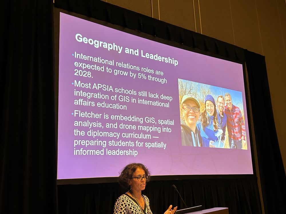
GIS supports international relations.
July 13, 2025 at 4:07 PM
GIS supports international relations.
It’s time for my first ArcGIS StoryMaps presentation of the #EsriUC2025 (I’m not giving this one, just attending it). I’m excited to see what Allen and Du have to say!

July 12, 2025 at 10:32 PM
It’s time for my first ArcGIS StoryMaps presentation of the #EsriUC2025 (I’m not giving this one, just attending it). I’m excited to see what Allen and Du have to say!

Reposted by Shane Bradt

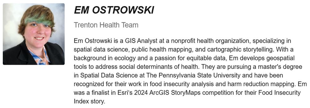
I'll be presenting the NJ Food Insecurity Index I developed during “Analyzing Food Insecurity & Pediatric Health Through GIS Mapping” at #EsriUC!
Join me July 17, 2:30–3:30 PM PDT, Pacific Ballroom Salon 23. Let’s talk GIS, public health & equity. DM if you’ll be in San Diego! #GIS #GISChat #PSU
Join me July 17, 2:30–3:30 PM PDT, Pacific Ballroom Salon 23. Let’s talk GIS, public health & equity. DM if you’ll be in San Diego! #GIS #GISChat #PSU
July 10, 2025 at 8:20 PM
Reposted by Shane Bradt
Had a lot of fun chatting news mapping again with the Esri maps(dot)com team!
And check out the thematic mapping sessions at #EsriUC2025!
And check out the thematic mapping sessions at #EsriUC2025!

Top insights on mapping from our colleague @tierneymaps.bsky.social Looking forward to presenting with her and @johnnelsonmaps.bsky.social at #EsriUC. Bookmark the Thematic Mapping Tech Workshops. youtu.be/zF6z_Z7m9gI?...

Making Maps for the News | Behind the Map
YouTube video by Maps Dot Com
youtu.be
July 1, 2025 at 1:14 PM
Had a lot of fun chatting news mapping again with the Esri maps(dot)com team!
And check out the thematic mapping sessions at #EsriUC2025!
And check out the thematic mapping sessions at #EsriUC2025!
Reposted by Shane Bradt
Dr Kolvoord addresses the education summit attendees about the geospatial semester and its impact over the past twenty years !

July 12, 2025 at 6:07 PM
Dr Kolvoord addresses the education summit attendees about the geospatial semester and its impact over the past twenty years !
Reposted by Shane Bradt
(1/2) Are you a cartographer attending #EsriUC2025? To help plan your week, I've put together a couple resources to get you started.
First up, a quick start guide:
storymaps.arcgis.com/stories/3978... #mapping #cartography
First up, a quick start guide:
storymaps.arcgis.com/stories/3978... #mapping #cartography
Cartography at UC 2025: A Quick Start Guide
A list of cartographic happenings at UC
storymaps.arcgis.com
June 26, 2025 at 4:32 PM
(1/2) Are you a cartographer attending #EsriUC2025? To help plan your week, I've put together a couple resources to get you started.
First up, a quick start guide:
storymaps.arcgis.com/stories/3978... #mapping #cartography
First up, a quick start guide:
storymaps.arcgis.com/stories/3978... #mapping #cartography
Attending the #EsriUC2025 Education Summit and like to chat about #ArcGISDashboards? Please don't be shy, even if you miss my talk -8:30am on Saturday, first session of the conference!
PS: I love chatting about ArcGISStoryMaps too if they are more your speed.
uc2025.esri.com/flow/esri/25...
PS: I love chatting about ArcGISStoryMaps too if they are more your speed.
uc2025.esri.com/flow/esri/25...

July 11, 2025 at 4:54 PM
Attending the #EsriUC2025 Education Summit and like to chat about #ArcGISDashboards? Please don't be shy, even if you miss my talk -8:30am on Saturday, first session of the conference!
PS: I love chatting about ArcGISStoryMaps too if they are more your speed.
uc2025.esri.com/flow/esri/25...
PS: I love chatting about ArcGISStoryMaps too if they are more your speed.
uc2025.esri.com/flow/esri/25...
Reposted by Shane Bradt
community.esri.com/t5/education... How walkable is YOUR community? Take my open survey, see results in map and dashboard, and think about using these same ArcGIS tools to gather, map, and analyze your OWN data that you care about in your own community.
How walkable is your community?
I invite you to explore the Community Walkability map I created, here: https://storymaps.arcgis.com/stories/1e4847f78ec94fd89e960adfabb5ac5c This is a new ArcGIS storymap, and it also includes a butt...
community.esri.com
June 6, 2025 at 5:26 PM
community.esri.com/t5/education... How walkable is YOUR community? Take my open survey, see results in map and dashboard, and think about using these same ArcGIS tools to gather, map, and analyze your OWN data that you care about in your own community.
I'm excited to share some of my own #ArcGISDashboard tips and tricks at the #EsriUC this summer during the Education Summit - don't sleep in on Saturday or you'll miss it!
uc2025.esri.com/flow/esri/25...
uc2025.esri.com/flow/esri/25...

May 15, 2025 at 5:02 PM
I'm excited to share some of my own #ArcGISDashboard tips and tricks at the #EsriUC this summer during the Education Summit - don't sleep in on Saturday or you'll miss it!
uc2025.esri.com/flow/esri/25...
uc2025.esri.com/flow/esri/25...
Reposted by Shane Bradt
Greetings All: Beginning with a book I co-authored for Esri Press, here is our blog about where to find data, how to know if it is any GOOD, and issues such as data quality, location privacy, copyright, ethics, and more, written in a style to spark discussions: spatialreserves.wordpress.com

Spatial Reserves
A guide to public domain spatial data
spatialreserves.wordpress.com
May 12, 2025 at 6:38 PM
Greetings All: Beginning with a book I co-authored for Esri Press, here is our blog about where to find data, how to know if it is any GOOD, and issues such as data quality, location privacy, copyright, ethics, and more, written in a style to spark discussions: spatialreserves.wordpress.com
Reposted by Shane Bradt

Reserve your spot for my Science Summit at the Esri User Conference, featuring Dr. Francesca Dominici of Harvard on public health! Once you register for #EsriUC2025, just add this session to your schedule to save your place. Be sure to make your reservation early! ow.ly/wcuA50VEH8x
#gischat #geosky
#gischat #geosky

2025 Science Summit @ Esri UC: July 15 in San Diego, CA
Join Dr. Dawn Wright at the Science Summit @ Esri UC to discover how geospatial technology enhances climate resilience and benefits our planet and communities.
ow.ly
April 28, 2025 at 3:12 AM
Reserve your spot for my Science Summit at the Esri User Conference, featuring Dr. Francesca Dominici of Harvard on public health! Once you register for #EsriUC2025, just add this session to your schedule to save your place. Be sure to make your reservation early! ow.ly/wcuA50VEH8x
#gischat #geosky
#gischat #geosky