


griteater
@griteater.bsky.social
Charlotte, NC. I’m a winter weather nut living in a warm climate in North Carolina, and neither of those is going to change
This winter has one of the bigger disconnects seen for troposphere vs. stratosphere Arctic Oscillation (AO) / Northern Annular Mode (NAM)

February 17, 2025 at 8:07 PM
This winter has one of the bigger disconnects seen for troposphere vs. stratosphere Arctic Oscillation (AO) / Northern Annular Mode (NAM)
Gosh Amy, thanks so much. Everything’s not ENSO, everything’s not MJO, everything’s not stratosphere. Gotta see the whole picture
(5/5) Same story using zonal-mean diagnostics- the stratosphere and troposphere are not at all coupled right now. Sometimes, cold and snowy weather is just... weather. It's not related to the #polarvortex every time we get some Arctic air down here.

January 7, 2025 at 2:40 AM
Gosh Amy, thanks so much. Everything’s not ENSO, everything’s not MJO, everything’s not stratosphere. Gotta see the whole picture
End of the Euro run may be the best-shaped boot pattern I've ever seen 😎

December 24, 2024 at 6:53 AM
End of the Euro run may be the best-shaped boot pattern I've ever seen 😎
Reposted by griteater
This is my morning's exciting discovery- the #QBO time series that was produced and maintained at Freie Universitat Berlin for many years but had stopped updating a couple of years ago will now be available from KIT, with a nice new webpage to boot: www.atmohub.kit.edu/english/807....
KIT - ATMO Hub of KIT - ATMO Hub - Quasi-Biennial-Oszillation (QBO) Data SeriesKIT - Karlsruhe Institute of Technology
www.atmohub.kit.edu
December 18, 2024 at 5:59 PM
This is my morning's exciting discovery- the #QBO time series that was produced and maintained at Freie Universitat Berlin for many years but had stopped updating a couple of years ago will now be available from KIT, with a nice new webpage to boot: www.atmohub.kit.edu/english/807....
Recorded 1.0 inch of snow on snow board from 1:40 to 2:40 AM tonight in mesoscale snow band. Fun ❄️


December 3, 2024 at 8:20 AM
Recorded 1.0 inch of snow on snow board from 1:40 to 2:40 AM tonight in mesoscale snow band. Fun ❄️
Reposted by griteater
November 30th, 1784:
John Jeffries, one of America's first weather observers, became the first person to ascend in a balloon for the purpose of taking upper air meteorological measurements. He took a thermometer, a barometer, and a hygrometer to the height of 9000 feet over London, England.
John Jeffries, one of America's first weather observers, became the first person to ascend in a balloon for the purpose of taking upper air meteorological measurements. He took a thermometer, a barometer, and a hygrometer to the height of 9000 feet over London, England.


November 30, 2024 at 3:07 PM
November 30th, 1784:
John Jeffries, one of America's first weather observers, became the first person to ascend in a balloon for the purpose of taking upper air meteorological measurements. He took a thermometer, a barometer, and a hygrometer to the height of 9000 feet over London, England.
John Jeffries, one of America's first weather observers, became the first person to ascend in a balloon for the purpose of taking upper air meteorological measurements. He took a thermometer, a barometer, and a hygrometer to the height of 9000 feet over London, England.
Modeling in fair agreement in the extended range of significant jet extension via high pressure / cold surge working off East Asia - with the end result being a Moderate El Niño look in early December


November 21, 2024 at 2:41 AM
Modeling in fair agreement in the extended range of significant jet extension via high pressure / cold surge working off East Asia - with the end result being a Moderate El Niño look in early December
Reposted by griteater

Hawk sitting on a tree at Country Park in Greensboro this morning.

November 19, 2024 at 4:57 PM
Hawk sitting on a tree at Country Park in Greensboro this morning.
Up close, firsthand account of rising water from the storm (Helene) along the Cane River, a secluded area just NW of Burnsville, NC near the NC/TN line
Yancey County Burnsville flood 2024, Jay-Paul Thibault youtu.be/C4xA7QfIOdo?... via @YouTube
Yancey County Burnsville flood 2024, Jay-Paul Thibault youtu.be/C4xA7QfIOdo?... via @YouTube


October 6, 2024 at 4:50 PM
Up close, firsthand account of rising water from the storm (Helene) along the Cane River, a secluded area just NW of Burnsville, NC near the NC/TN line
Yancey County Burnsville flood 2024, Jay-Paul Thibault youtu.be/C4xA7QfIOdo?... via @YouTube
Yancey County Burnsville flood 2024, Jay-Paul Thibault youtu.be/C4xA7QfIOdo?... via @YouTube
The stratosphere is 'doing its job.' Now to get the other pieces to fall into place to deliver winter storms


February 6, 2024 at 8:08 PM
The stratosphere is 'doing its job.' Now to get the other pieces to fall into place to deliver winter storms
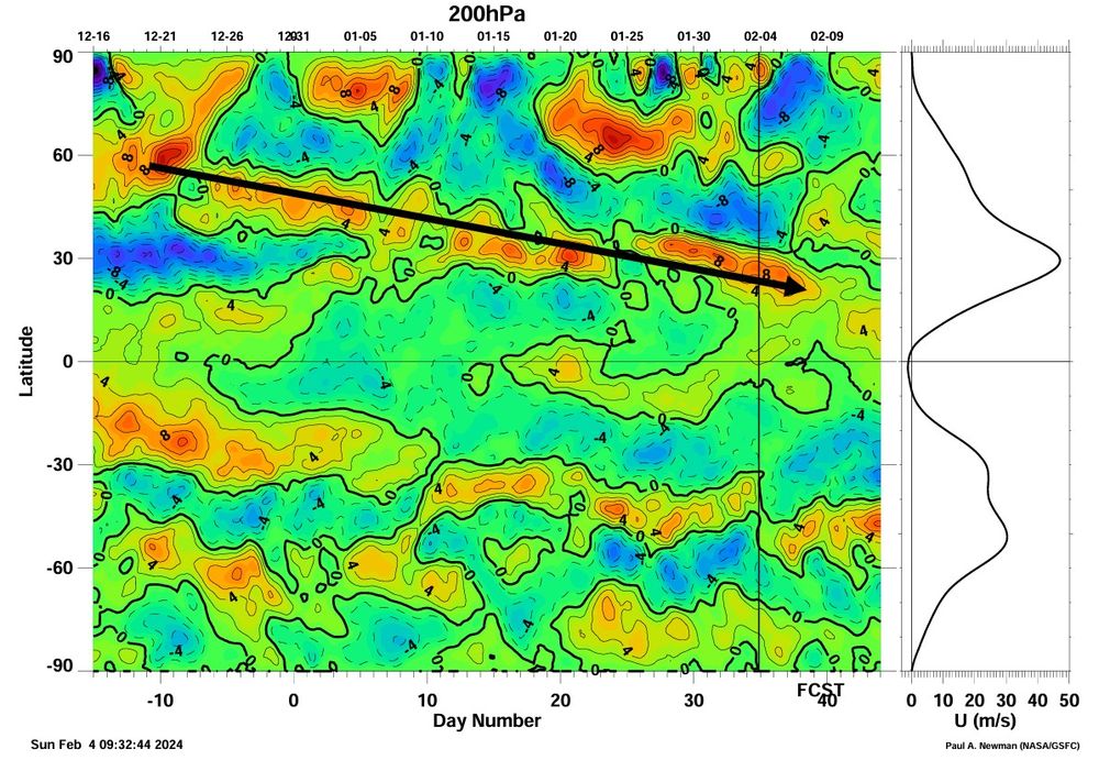
This is as far south as you will ever see the STJ here on the GEFS as the mean wave in the flow is entering N Amer south of Baja. That's unheard of. The mean jet stream zonal wind anomalies have steadily moved south from Dec into Feb, common in robust El Ninos as EWebb showed

February 4, 2024 at 6:44 PM
This is as far south as you will ever see the STJ here on the GEFS as the mean wave in the flow is entering N Amer south of Baja. That's unheard of. The mean jet stream zonal wind anomalies have steadily moved south from Dec into Feb, common in robust El Ninos as EWebb showed
Tonight's WPC 500mb forecast at Day 7 is in lock step with the 12z Euro Ens Mean with respect to the placement of the confluence zone running thru North Carolina. Where will we go from here??

January 28, 2024 at 3:32 AM
Tonight's WPC 500mb forecast at Day 7 is in lock step with the 12z Euro Ens Mean with respect to the placement of the confluence zone running thru North Carolina. Where will we go from here??
Flip from Low pressure to High pressure in EAsia in early Feb should lead to momentum added into the Pac Jet w/ Aleutian Low swelling & moving east, making the southern stream active underneath increasing high latitude blocking in the WHemisphere (AK to Greenland) in mid-late Feb


January 26, 2024 at 2:28 AM
Flip from Low pressure to High pressure in EAsia in early Feb should lead to momentum added into the Pac Jet w/ Aleutian Low swelling & moving east, making the southern stream active underneath increasing high latitude blocking in the WHemisphere (AK to Greenland) in mid-late Feb
NOAA CPC Weekly MJO Update

January 15, 2024 at 8:30 PM
NOAA CPC Weekly MJO Update
Not the kind of action I’m looking for, but active

January 9, 2024 at 5:08 PM
Not the kind of action I’m looking for, but active
This was well done Amy. Informative. Enjoyed it
Check out the latest Polar Vortex Blog post on reasons why the minor #SSW wasn't able to quite make it to major status... and chances of that changing in the next couple of weeks! www.climate.gov/news-feature...
Cooking up a stratospheric polar vortex disruption
Recent atmospheric patterns don't match those that typically precede a sudden stratospheric warming event. But forecasts do suggest the polar vortex might get stretched out of shape in coming weeks.
www.climate.gov
January 8, 2024 at 10:33 PM
This was well done Amy. Informative. Enjoyed it
NASA GEOS MERRA2 forecast showing record / near record low zonal winds in the lower stratosphere here in mid-Jan (100mb)

January 6, 2024 at 4:11 PM
NASA GEOS MERRA2 forecast showing record / near record low zonal winds in the lower stratosphere here in mid-Jan (100mb)
Falling zonal wind trend shown for Jan 16-17 on last 4 00z runs of the GEFS, with large drop in the most recent run
In addition, the 06z GFS Operational run shows an official SSW on January 16th
In addition, the 06z GFS Operational run shows an official SSW on January 16th


January 6, 2024 at 1:50 PM
Falling zonal wind trend shown for Jan 16-17 on last 4 00z runs of the GEFS, with large drop in the most recent run
In addition, the 06z GFS Operational run shows an official SSW on January 16th
In addition, the 06z GFS Operational run shows an official SSW on January 16th
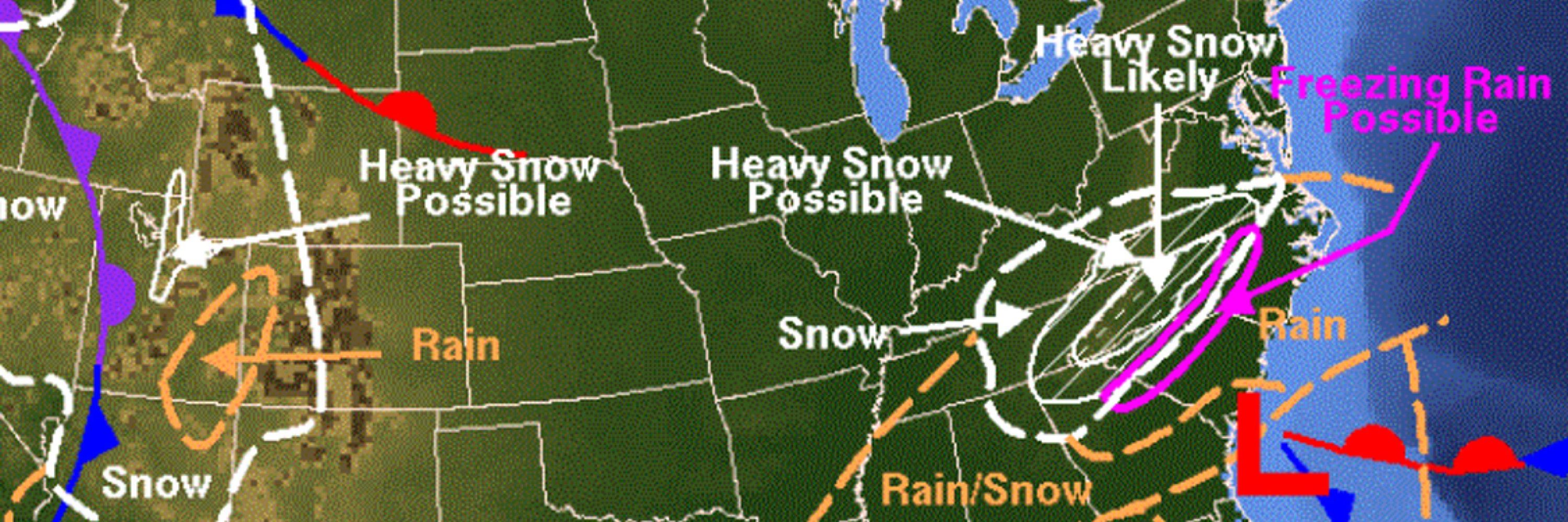
Surely the Mid-Atlantic can muster up some type of winter storm threat with this kind of 5-day averaged pattern (Dec30 - Jan4)


December 19, 2023 at 7:04 PM
Surely the Mid-Atlantic can muster up some type of winter storm threat with this kind of 5-day averaged pattern (Dec30 - Jan4)
The Equatorial SOI (a quality ENSO metric) 3-month average for Sep-Nov was -1.33 (6th lowest since 1950).
EQSOI is a measure of surface pressure anomalies between Indonesia and the Eastern Equatorial Pacific
EQSOI is a measure of surface pressure anomalies between Indonesia and the Eastern Equatorial Pacific


December 12, 2023 at 8:54 PM
The Equatorial SOI (a quality ENSO metric) 3-month average for Sep-Nov was -1.33 (6th lowest since 1950).
EQSOI is a measure of surface pressure anomalies between Indonesia and the Eastern Equatorial Pacific
EQSOI is a measure of surface pressure anomalies between Indonesia and the Eastern Equatorial Pacific

December 8, 2023 at 4:33 PM
An image of split jets across the Pacific - North America region

December 6, 2023 at 6:02 PM
An image of split jets across the Pacific - North America region
My thoughts on the upcoming weather pattern (Dec15-Jan5) and whether it offers potential for winter weather in the Southeast and Southern Mid-Atlantic

December 1, 2023 at 2:28 PM
My thoughts on the upcoming weather pattern (Dec15-Jan5) and whether it offers potential for winter weather in the Southeast and Southern Mid-Atlantic
You can get old Global Wind Oscillation charts (AAM) off the tables at this link: www.sierraphotography.com/wxnotes/
Here is a comparison of Nov-Mar 1982-1983 to Oct-Dec (forecast) of this year
Here is a comparison of Nov-Mar 1982-1983 to Oct-Dec (forecast) of this year


November 30, 2023 at 3:41 PM
You can get old Global Wind Oscillation charts (AAM) off the tables at this link: www.sierraphotography.com/wxnotes/
Here is a comparison of Nov-Mar 1982-1983 to Oct-Dec (forecast) of this year
Here is a comparison of Nov-Mar 1982-1983 to Oct-Dec (forecast) of this year
If we crunch the latest weekly Nino3.4 numbers and account for more increases this week before it levels off, I came up with a November monthly estimate of +2.01
Here is how that compares with other El Ninos...
Here is how that compares with other El Ninos...

November 20, 2023 at 10:38 PM
If we crunch the latest weekly Nino3.4 numbers and account for more increases this week before it levels off, I came up with a November monthly estimate of +2.01
Here is how that compares with other El Ninos...
Here is how that compares with other El Ninos...