


Michal Břežný
@geomikesh.bsky.social
#geomorphology, #geomorphometry #landslides, #nature, #computers and #GIS
University of Ostrava. Czechia
University of Ostrava. Czechia
Reposted by Michal Břežný

My rapid analysis of the recent GLOF (?) in Gupis, Gilgit-Baltistan www.cesbio.cnrs.fr/multitemp/ra...
August 24, 2025 at 1:23 AM
My rapid analysis of the recent GLOF (?) in Gupis, Gilgit-Baltistan www.cesbio.cnrs.fr/multitemp/ra...
Reposted by Michal Břežný

On 24 June 2025, a significant landslide destroyed the Houzihé Grand Bridge on the Xiarong Expressway in Guizhou, China. A truck driver had an extremely lucky escape when his vehicle was left dangling into the void.
eos.org/thelandslide...
eos.org/thelandslide...

June 25, 2025 at 7:48 AM
On 24 June 2025, a significant landslide destroyed the Houzihé Grand Bridge on the Xiarong Expressway in Guizhou, China. A truck driver had an extremely lucky escape when his vehicle was left dangling into the void.
eos.org/thelandslide...
eos.org/thelandslide...
Reposted by Michal Břežný
Back from the mountain rivers of Greece! We collected field data for simulating future floods in a catchment hit by Storm Daniel in 2023.
Bonus: photos captured on 35mm film with my old Leica 📷🌊
Bonus: photos captured on 35mm film with my old Leica 📷🌊


June 23, 2025 at 7:53 PM
Back from the mountain rivers of Greece! We collected field data for simulating future floods in a catchment hit by Storm Daniel in 2023.
Bonus: photos captured on 35mm film with my old Leica 📷🌊
Bonus: photos captured on 35mm film with my old Leica 📷🌊
Reposted by Michal Břežný
🚨 New paper out in CATENA! After 6 years of fieldwork in Czech headwater streams, we show:
✅ In channelized streams, gravel moves farther.
✅ In near-natural streams, sediment transport is more predictable—better linked to flow magnitude & duration.
Read more: www.sciencedirect.com/science/arti...
✅ In channelized streams, gravel moves farther.
✅ In near-natural streams, sediment transport is more predictable—better linked to flow magnitude & duration.
Read more: www.sciencedirect.com/science/arti...


June 23, 2025 at 7:46 PM
🚨 New paper out in CATENA! After 6 years of fieldwork in Czech headwater streams, we show:
✅ In channelized streams, gravel moves farther.
✅ In near-natural streams, sediment transport is more predictable—better linked to flow magnitude & duration.
Read more: www.sciencedirect.com/science/arti...
✅ In channelized streams, gravel moves farther.
✅ In near-natural streams, sediment transport is more predictable—better linked to flow magnitude & duration.
Read more: www.sciencedirect.com/science/arti...
Reposted by Michal Břežný


Návrat k událostem, které vedly k pohřbení vesnice Blatten. Aneb krátce o sesuvech a změně klimatu.
ekolist.cz/cz/publicist...
ekolist.cz/cz/publicist...

Změna klimatu a sesuvy v horách: Co ukázal případ Blatten - Ekolist.cz
Katastrofický kolaps ledovce ve švýcarské vesnici Blatten v květnu 2025 připomněl, že hory nejsou jen klidné scenérie, ale krajina v pohybu. Klimatická změna narušuje jejich stabilitu – tání ledovců i...
ekolist.cz
June 23, 2025 at 8:16 AM
Návrat k událostem, které vedly k pohřbení vesnice Blatten. Aneb krátce o sesuvech a změně klimatu.
ekolist.cz/cz/publicist...
ekolist.cz/cz/publicist...
Reposted by Michal Břežný
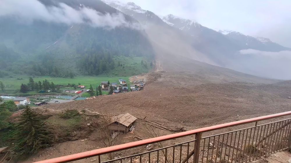
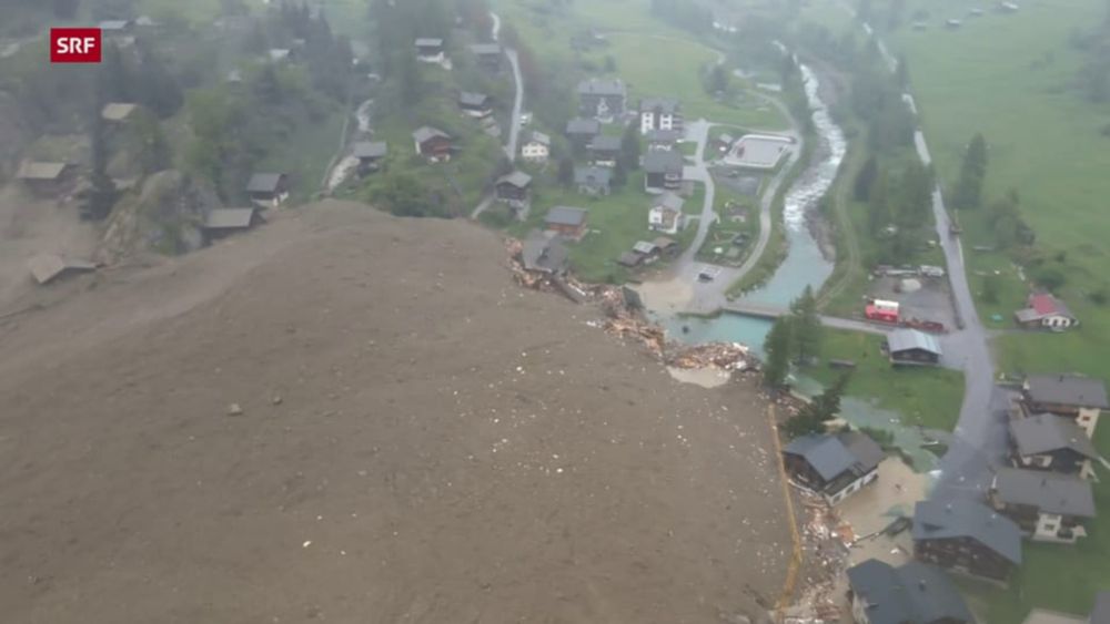
First drone flight today at Blatten! 🌊🎥
Water has made its path through the deposit!
A spillover is currently not expected
Slight lowering of upstream lake, which is currently not high enough to spill over the debris cone
Several new lakes created on the deposit
Source SRF
1/
Water has made its path through the deposit!
A spillover is currently not expected
Slight lowering of upstream lake, which is currently not high enough to spill over the debris cone
Several new lakes created on the deposit
Source SRF
1/


May 30, 2025 at 11:56 AM
First drone flight today at Blatten! 🌊🎥
Water has made its path through the deposit!
A spillover is currently not expected
Slight lowering of upstream lake, which is currently not high enough to spill over the debris cone
Several new lakes created on the deposit
Source SRF
1/
Water has made its path through the deposit!
A spillover is currently not expected
Slight lowering of upstream lake, which is currently not high enough to spill over the debris cone
Several new lakes created on the deposit
Source SRF
1/
Reposted by Michal Břežný
BEFORE / AFTER Birch glacier collapse 😮😱
There WAS a glacier here! 🧊
Not only the front, but the entire ice mass has slid down the valley! 🌊
Glad Alain Amherd took two pics with the same angle! 📷🙏
There WAS a glacier here! 🧊
Not only the front, but the entire ice mass has slid down the valley! 🌊
Glad Alain Amherd took two pics with the same angle! 📷🙏
May 29, 2025 at 9:42 PM
BEFORE / AFTER Birch glacier collapse 😮😱
There WAS a glacier here! 🧊
Not only the front, but the entire ice mass has slid down the valley! 🌊
Glad Alain Amherd took two pics with the same angle! 📷🙏
There WAS a glacier here! 🧊
Not only the front, but the entire ice mass has slid down the valley! 🌊
Glad Alain Amherd took two pics with the same angle! 📷🙏
Reposted by Michal Břežný
The extent of the deposit from the Birch Glacier collapse over Blatten as seen by newly available high-resolution satellite imagery collected by Maxar! 🛰️
Processed by @wxnb.bsky.social
Processed by @wxnb.bsky.social
May 29, 2025 at 5:00 PM
The extent of the deposit from the Birch Glacier collapse over Blatten as seen by newly available high-resolution satellite imagery collected by Maxar! 🛰️
Processed by @wxnb.bsky.social
Processed by @wxnb.bsky.social
Reposted by Michal Břežný

🌍 Michal Břežný, Ph.D.– Svahy v pohybu: Ujíždí nám zem pod nohama?
@geomikesh.bsky.social
@geomikesh.bsky.social

May 29, 2025 at 1:47 PM
🌍 Michal Břežný, Ph.D.– Svahy v pohybu: Ujíždí nám zem pod nohama?
@geomikesh.bsky.social
@geomikesh.bsky.social
Reposted by Michal Břežný
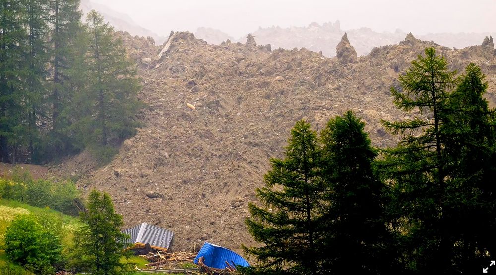
Aerial view westward over the Blatten deposit and the newly formed lake upstream! 🧊🌊
📷Via Christian Petit/Linkedin
📷Via Christian Petit/Linkedin

May 29, 2025 at 3:55 PM
Aerial view westward over the Blatten deposit and the newly formed lake upstream! 🧊🌊
📷Via Christian Petit/Linkedin
📷Via Christian Petit/Linkedin
Reposted by Michal Břežný
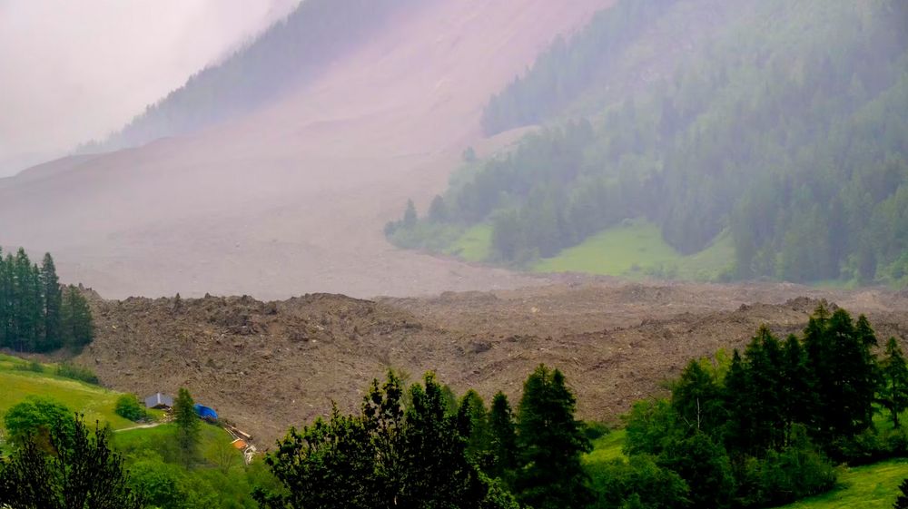
The fascinating thing about these images of the #Blatten event is the scale of the original rockslide that got us all excited a week ago. It is just visible towards the top of the slope. This is a posterchild for a complex, cascading hazard that evolves rapidly and unpredictably.
Absolutely stunning frontal views of the entire path of the #Blatten event! 😮
Numerous debris flow run through the avalanche fan! 🌊
Shot by @ABettmeralp in early afternoon 🙏
Numerous debris flow run through the avalanche fan! 🌊
Shot by @ABettmeralp in early afternoon 🙏


May 29, 2025 at 1:35 PM
The fascinating thing about these images of the #Blatten event is the scale of the original rockslide that got us all excited a week ago. It is just visible towards the top of the slope. This is a posterchild for a complex, cascading hazard that evolves rapidly and unpredictably.
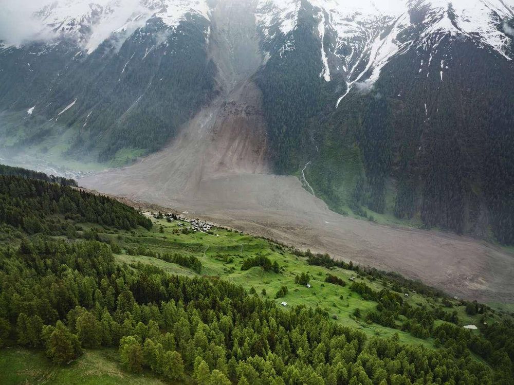
Švýcarská vesnice Blatten byla dnes z velké části pohřbena pod masou ledu, sutě a kmenů. Kolaps ledovce Birch završil několikadenní drama. To začalo murou, evakuací vesnice a sesuvem z Kleine Nesthorn. Sesuv způsobil zrychlení pohybu ledovce, které vyústilo v dnešní kolaps.
INCREDIBLE !!
Here we are... 😱😱😱
After days of overloading and cracks propagating, Birch Glacier collapsed today at 3.24 pm over Blatten and the dammed Lonza river...
Devastating! 😭
www.letemps.ch/suisse/valai...
Here we are... 😱😱😱
After days of overloading and cracks propagating, Birch Glacier collapsed today at 3.24 pm over Blatten and the dammed Lonza river...
Devastating! 😭
www.letemps.ch/suisse/valai...
May 28, 2025 at 8:24 PM
Švýcarská vesnice Blatten byla dnes z velké části pohřbena pod masou ledu, sutě a kmenů. Kolaps ledovce Birch završil několikadenní drama. To začalo murou, evakuací vesnice a sesuvem z Kleine Nesthorn. Sesuv způsobil zrychlení pohybu ledovce, které vyústilo v dnešní kolaps.
Reposted by Michal Břežný
INCREDIBLE !!
Here we are... 😱😱😱
After days of overloading and cracks propagating, Birch Glacier collapsed today at 3.24 pm over Blatten and the dammed Lonza river...
Devastating! 😭
www.letemps.ch/suisse/valai...
Here we are... 😱😱😱
After days of overloading and cracks propagating, Birch Glacier collapsed today at 3.24 pm over Blatten and the dammed Lonza river...
Devastating! 😭
www.letemps.ch/suisse/valai...
May 28, 2025 at 3:09 PM
INCREDIBLE !!
Here we are... 😱😱😱
After days of overloading and cracks propagating, Birch Glacier collapsed today at 3.24 pm over Blatten and the dammed Lonza river...
Devastating! 😭
www.letemps.ch/suisse/valai...
Here we are... 😱😱😱
After days of overloading and cracks propagating, Birch Glacier collapsed today at 3.24 pm over Blatten and the dammed Lonza river...
Devastating! 😭
www.letemps.ch/suisse/valai...
Reposted by Michal Břežný
May 28, 2025 at 4:14 PM
Reposted by Michal Břežný

Reposted by Michal Břežný
Before and after image of the large glacier collapse that covered parts of the Swiss village #Blatten.
The animation is stabilized/aligned from a version shared by Pomona/Alain Amherd
Source: pomona.ch/en/story/590...
The animation is stabilized/aligned from a version shared by Pomona/Alain Amherd
Source: pomona.ch/en/story/590...
May 28, 2025 at 4:05 PM
Before and after image of the large glacier collapse that covered parts of the Swiss village #Blatten.
The animation is stabilized/aligned from a version shared by Pomona/Alain Amherd
Source: pomona.ch/en/story/590...
The animation is stabilized/aligned from a version shared by Pomona/Alain Amherd
Source: pomona.ch/en/story/590...
Reposted by Michal Břežný
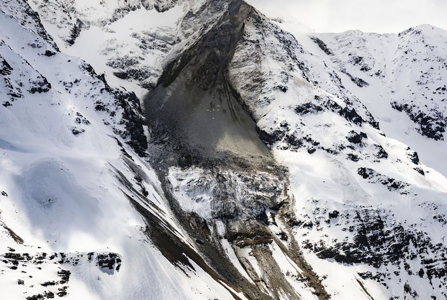
#Blatten Press conference Alban Brigger,
-glacier front velocity is 2.5-3 m/day. ‘We do not expect an exponential acceleration, as we feared before.’
-the amount of debris deposited on the glacier is 3.5 Mm3 = 9 M t. Up to 80 m thick!
1/
📷 Keystone
-glacier front velocity is 2.5-3 m/day. ‘We do not expect an exponential acceleration, as we feared before.’
-the amount of debris deposited on the glacier is 3.5 Mm3 = 9 M t. Up to 80 m thick!
1/
📷 Keystone
May 26, 2025 at 10:08 AM
#Blatten Press conference Alban Brigger,
-glacier front velocity is 2.5-3 m/day. ‘We do not expect an exponential acceleration, as we feared before.’
-the amount of debris deposited on the glacier is 3.5 Mm3 = 9 M t. Up to 80 m thick!
1/
📷 Keystone
-glacier front velocity is 2.5-3 m/day. ‘We do not expect an exponential acceleration, as we feared before.’
-the amount of debris deposited on the glacier is 3.5 Mm3 = 9 M t. Up to 80 m thick!
1/
📷 Keystone
Reposted by Michal Břežný
This is a completely new landslide trigger for me - the impact of a 100 m cargo ship. Utterly bizarre.

And in related weird news, a quick clay slide was triggered near Trondheim, Norway, when a container ship ran aground next to a house! www.nrk.no/trondelag/hu...
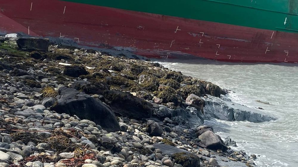
Hus evakueres etter leirras like ved containerskip på Byneset i Trondheim
Like ved stedet lasteskipet traff land har det gått et 100 meter bredt leirskred.
www.nrk.no
May 22, 2025 at 2:23 PM
This is a completely new landslide trigger for me - the impact of a 100 m cargo ship. Utterly bizarre.
Reposted by Michal Břežný
🛸 Jan Pergl, Ph.D. – Nevítaní vetřelci: Čeká nás Den trifidů? @jan-honza-pergl.bsky.social
🌍 Michal Břežný, Ph.D.– Svahy v pohybu: Ujíždí nám zem pod nohama? @geomikesh.bsky.social
🌃 Mgr. Vendula Lužná, Ph.D. – Světlo, přítel člověka: Jak moc nás ovlivňuje světelný smog?
🌍 Michal Břežný, Ph.D.– Svahy v pohybu: Ujíždí nám zem pod nohama? @geomikesh.bsky.social
🌃 Mgr. Vendula Lužná, Ph.D. – Světlo, přítel člověka: Jak moc nás ovlivňuje světelný smog?
May 21, 2025 at 5:24 PM
🛸 Jan Pergl, Ph.D. – Nevítaní vetřelci: Čeká nás Den trifidů? @jan-honza-pergl.bsky.social
🌍 Michal Břežný, Ph.D.– Svahy v pohybu: Ujíždí nám zem pod nohama? @geomikesh.bsky.social
🌃 Mgr. Vendula Lužná, Ph.D. – Světlo, přítel člověka: Jak moc nás ovlivňuje světelný smog?
🌍 Michal Břežný, Ph.D.– Svahy v pohybu: Ujíždí nám zem pod nohama? @geomikesh.bsky.social
🌃 Mgr. Vendula Lužná, Ph.D. – Světlo, přítel člověka: Jak moc nás ovlivňuje světelný smog?
Ve Švýcarských Alpách nikterak malý (asi 5 miliónů m3 skály) aktivní sesuv ohrožuje vesnici, která musel být evakuována.
Online reportáž a další snímky najdete zde: www.aargauerzeitung.ch/schweiz/droh...
Případně sledujte @subfossilguy.bsky.social
Online reportáž a další snímky najdete zde: www.aargauerzeitung.ch/schweiz/droh...
Případně sledujte @subfossilguy.bsky.social
May 20, 2025 at 12:25 PM
Ve Švýcarských Alpách nikterak malý (asi 5 miliónů m3 skály) aktivní sesuv ohrožuje vesnici, která musel být evakuována.
Online reportáž a další snímky najdete zde: www.aargauerzeitung.ch/schweiz/droh...
Případně sledujte @subfossilguy.bsky.social
Online reportáž a další snímky najdete zde: www.aargauerzeitung.ch/schweiz/droh...
Případně sledujte @subfossilguy.bsky.social
Reposted by Michal Břežný
Today (~12pm) the scar has reached the top of Klein #Nesthorn which resulted in a lowering of the crest and a ruiniform morphology!😳😱
📷 sensalpin.ch
📷 sensalpin.ch

May 19, 2025 at 3:14 PM
Today (~12pm) the scar has reached the top of Klein #Nesthorn which resulted in a lowering of the crest and a ruiniform morphology!😳😱
📷 sensalpin.ch
📷 sensalpin.ch
Reposted by Michal Břežný
Already + 100,000 m3 fallen from the Klein Nesthorn N face at ~3200 m asl, and something between 1 to 5 Millions m3 more are 'forecasted'... 😱
That's quite a thing!
Blatten village evacuated 😭
The 'Crumblocene' is definitely a nice time to live! 🏔️🌊
www.20min.ch/fr/story/can...
That's quite a thing!
Blatten village evacuated 😭
The 'Crumblocene' is definitely a nice time to live! 🏔️🌊
www.20min.ch/fr/story/can...
May 19, 2025 at 2:33 PM
Already + 100,000 m3 fallen from the Klein Nesthorn N face at ~3200 m asl, and something between 1 to 5 Millions m3 more are 'forecasted'... 😱
That's quite a thing!
Blatten village evacuated 😭
The 'Crumblocene' is definitely a nice time to live! 🏔️🌊
www.20min.ch/fr/story/can...
That's quite a thing!
Blatten village evacuated 😭
The 'Crumblocene' is definitely a nice time to live! 🏔️🌊
www.20min.ch/fr/story/can...
Reposted by Michal Břežný

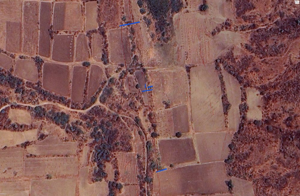
I discovered today that Google Earth now has post-earthquake imagery from the 3/28/25 M7.8 earthquake in Myanmar. The area includes the site we trenched in 2018 before the earthquake to look for evidence of past earthquakes. The image shows the locations of our trenches with the 2025 ruptures. 1/3
May 14, 2025 at 3:25 AM
I discovered today that Google Earth now has post-earthquake imagery from the 3/28/25 M7.8 earthquake in Myanmar. The area includes the site we trenched in 2018 before the earthquake to look for evidence of past earthquakes. The image shows the locations of our trenches with the 2025 ruptures. 1/3
Reposted by Michal Břežný
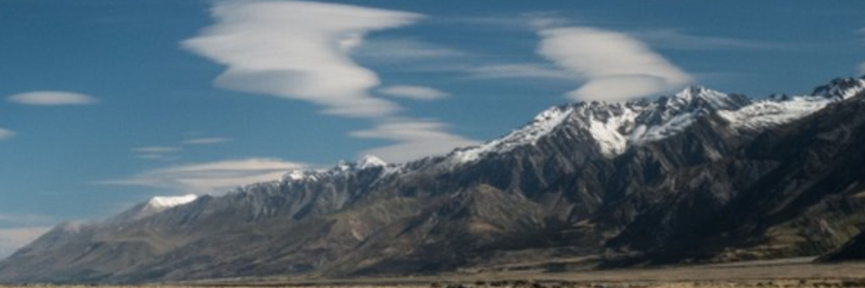
A bit of a break during fieldwork—here are a few analog shots from our monitoring of gravel bars on the Elbe River near the CZ/DE border. Captured with a 70y old Leica IIIg + Elmar 50 mm 3.5 + Fomapan Ortho 400. Always nice to mix science with some classic photography!


May 8, 2025 at 7:44 PM
A bit of a break during fieldwork—here are a few analog shots from our monitoring of gravel bars on the Elbe River near the CZ/DE border. Captured with a 70y old Leica IIIg + Elmar 50 mm 3.5 + Fomapan Ortho 400. Always nice to mix science with some classic photography!