


Randy Chase
@dopplerchase.bsky.social
Atmospheric Data Scientist @ tomorrow.io | Atmos AI Engineer 🤖 | μ-wave Nephologist ☁️ | Atmos PhD UofIllinois | #BillsMafia #Illini | he/him | Opinions my own |
Reposted by Randy Chase
Applications are open for the @ncar-cisl.bsky.social SIParCS summer internship program! It's a great opportunity for computationally-inclined students to get experience with real-world research problems spanning computational and Earth System Science. Link: ucar.wd5.myworkdayjobs.com/en-US/UCAR_C...

2026 SIParCS Undergraduate Student Internships
Job Description Summary: The Summer Internships in Parallel Computational Science (SIParCS) program at the National Center for Atmospheric Research (NCAR) offers graduate students and undergraduates w...
ucar.wd5.myworkdayjobs.com
November 3, 2025 at 10:59 PM
Applications are open for the @ncar-cisl.bsky.social SIParCS summer internship program! It's a great opportunity for computationally-inclined students to get experience with real-world research problems spanning computational and Earth System Science. Link: ucar.wd5.myworkdayjobs.com/en-US/UCAR_C...
🌀On the snap of my fingers, everyone will agree that NOAA and NSF should continue to do fundamental weather research 🫰

Alrighty, ready to see something really cool? (and maybe a little nauseating)
The evolution of Hurricane Melissa's mesovortices at peak strength.
The evolution of Hurricane Melissa's mesovortices at peak strength.
October 30, 2025 at 12:30 AM
🌀On the snap of my fingers, everyone will agree that NOAA and NSF should continue to do fundamental weather research 🫰
Some interesting views from low earth orbit of the effects of Melissa on land/ocean. Check out the brownish ocean color near land in the second picture. Sediment runoff
Before and after #HurricaneMelissa …ocean upwelling viewed from NOAA-21


October 29, 2025 at 9:52 PM
Some interesting views from low earth orbit of the effects of Melissa on land/ocean. Check out the brownish ocean color near land in the second picture. Sediment runoff
Reposted by Randy Chase

Calling all prospective grad students! 🚨
Come learn about CliMAS during our annual Prospective Graduate Student Webinar - featuring our internationally recognized on campus and online MS and PhD programs.
RSVP here to receive a Zoom link: forms.gle/CYsLWz5uoRNm....
Come learn about CliMAS during our annual Prospective Graduate Student Webinar - featuring our internationally recognized on campus and online MS and PhD programs.
RSVP here to receive a Zoom link: forms.gle/CYsLWz5uoRNm....

October 9, 2025 at 2:44 PM
Calling all prospective grad students! 🚨
Come learn about CliMAS during our annual Prospective Graduate Student Webinar - featuring our internationally recognized on campus and online MS and PhD programs.
RSVP here to receive a Zoom link: forms.gle/CYsLWz5uoRNm....
Come learn about CliMAS during our annual Prospective Graduate Student Webinar - featuring our internationally recognized on campus and online MS and PhD programs.
RSVP here to receive a Zoom link: forms.gle/CYsLWz5uoRNm....
Ever wonder what the second-wettest 24 hours on record in Salt Lake City looks like? A strong shortwave passed through on Saturday, delivering a rare all-day rain and dropping 2.39 inches at the airport!
October 7, 2025 at 1:46 AM
Ever wonder what the second-wettest 24 hours on record in Salt Lake City looks like? A strong shortwave passed through on Saturday, delivering a rare all-day rain and dropping 2.39 inches at the airport!
Love the visible marker of winter approaching

October 5, 2025 at 3:41 PM
Love the visible marker of winter approaching
Fall in Salt Lake. A short story 🍃


September 30, 2025 at 4:32 PM
Fall in Salt Lake. A short story 🍃
Overpass from two of tomorrow’s sounders this morning of Ragasa showing a concentric eyewall
September 23, 2025 at 10:21 PM
Overpass from two of tomorrow’s sounders this morning of Ragasa showing a concentric eyewall
Love fall cold fronts 🍃

September 22, 2025 at 5:47 PM
Love fall cold fronts 🍃
Reposted by Randy Chase

Want to come work for the National Hurricane Center, #NHC? There are two new job postings that were just announced yesterday. The 1st opportunity is a position within the #Hurricane Specialist Unit, #HSU:
GS-13 Hurricane Specialist Position -- www.usajobs.gov/job/845559000
GS-13 Hurricane Specialist Position -- www.usajobs.gov/job/845559000

Meteorologist
This position is located in the National Weather Service (NWS), National Hurricane Center (NHC), with one vacancy in Miami, FL.
www.usajobs.gov
September 11, 2025 at 5:10 PM
Want to come work for the National Hurricane Center, #NHC? There are two new job postings that were just announced yesterday. The 1st opportunity is a position within the #Hurricane Specialist Unit, #HSU:
GS-13 Hurricane Specialist Position -- www.usajobs.gov/job/845559000
GS-13 Hurricane Specialist Position -- www.usajobs.gov/job/845559000
Reposted by Randy Chase


It kills me that football is a game of inches and it still relies on refs “eye balling” where the ball was 🙄 Bills robbed of another drive from a poor spot
September 8, 2025 at 3:07 AM
It kills me that football is a game of inches and it still relies on refs “eye balling” where the ball was 🙄 Bills robbed of another drive from a poor spot
Reposted by Randy Chase

My lab at UCLA is hiring 1-2 PhD students this cycle!
Join us to work at the intersection of cognitive science and AI applied to pressing societal challenges like climate change.
More info about me: rachit-dubey.github.io
My lab: ucla-cocopol.github.io
Please help repost/spread the word!
Join us to work at the intersection of cognitive science and AI applied to pressing societal challenges like climate change.
More info about me: rachit-dubey.github.io
My lab: ucla-cocopol.github.io
Please help repost/spread the word!

September 3, 2025 at 12:19 AM
My lab at UCLA is hiring 1-2 PhD students this cycle!
Join us to work at the intersection of cognitive science and AI applied to pressing societal challenges like climate change.
More info about me: rachit-dubey.github.io
My lab: ucla-cocopol.github.io
Please help repost/spread the word!
Join us to work at the intersection of cognitive science and AI applied to pressing societal challenges like climate change.
More info about me: rachit-dubey.github.io
My lab: ucla-cocopol.github.io
Please help repost/spread the word!
Reposted by Randy Chase

🚨I’m recruiting 1-2 PhD students for my Air Quality Data Science 🌐 group @utah.edu (start Fall ’26), working on multimodal machine learning applications for atmospheric chemistry (wildfires, ozone, dust). How to apply below. Please repost & ping me with recommendations!

September 2, 2025 at 6:58 PM
🚨I’m recruiting 1-2 PhD students for my Air Quality Data Science 🌐 group @utah.edu (start Fall ’26), working on multimodal machine learning applications for atmospheric chemistry (wildfires, ozone, dust). How to apply below. Please repost & ping me with recommendations!
Last call to submit your awesome research to the weather community hang in Houston

⚡Last chance! Tomorrow is the LAST day to submit an abstract for the 106th Annual Meeting. The deadline is 5:00 PM ET on 21 August 🔐
Don’t wait until the last minute — submit yours today: https://bit.ly/3HZltIb #AMS2026
Don’t wait until the last minute — submit yours today: https://bit.ly/3HZltIb #AMS2026

August 20, 2025 at 9:53 PM
Last call to submit your awesome research to the weather community hang in Houston
22 scans of Hurricane Erin in just 4 days with tomorrow’s current constellation. Still more satellites to be launched this year and next, which will only increase the temporal coverage. www.linkedin.com/posts/tomorr...
August 19, 2025 at 5:22 PM
22 scans of Hurricane Erin in just 4 days with tomorrow’s current constellation. Still more satellites to be launched this year and next, which will only increase the temporal coverage. www.linkedin.com/posts/tomorr...
Today’s random weather data 🤔
August 19, 2025 at 12:10 AM
Today’s random weather data 🤔
Cockpit view from a hurricane hunter: www.linkedin.com/posts/carlne...

a close up of a man 's face with a blurred background
ALT: a close up of a man 's face with a blurred background
media.tenor.com
August 16, 2025 at 9:05 PM
Cockpit view from a hurricane hunter: www.linkedin.com/posts/carlne...
If we just had DVORAK and no recon for this storm, would it still be as strong as it is?
August 16, 2025 at 3:04 PM
If we just had DVORAK and no recon for this storm, would it still be as strong as it is?
Reposted by Randy Chase

Erin's currently estimated increase from 75 kt to 130 kt intensity (maximum sustained wind anywhere in the hurricane) in **12 hours** is a 55-kt change exceeded by only three Atlantic hurricanes in the past 50 years: 2005 Wilma (75 kt!), 2007 Felix (60 kt), and 2024 Milton (60 kt).
August 16, 2025 at 1:53 PM
Erin's currently estimated increase from 75 kt to 130 kt intensity (maximum sustained wind anywhere in the hurricane) in **12 hours** is a 55-kt change exceeded by only three Atlantic hurricanes in the past 50 years: 2005 Wilma (75 kt!), 2007 Felix (60 kt), and 2024 Milton (60 kt).
🌀 Hurricane #Erin as seen from NASA's GPM-DPR at 10:26 this am when it was around a CAT 3. Very small eye, 2 radar scans wide on the radar (~10 km)
August 16, 2025 at 1:41 PM
🌀 Hurricane #Erin as seen from NASA's GPM-DPR at 10:26 this am when it was around a CAT 3. Very small eye, 2 radar scans wide on the radar (~10 km)
Today we are announcing challenge 1 of the Build Tomorrow initiative! We are challenging the community to build hurricane intensity forecasts. If you want to participate be sure to sign up for email updates: build.tomorrow.io?utm_campaign...
August 14, 2025 at 2:54 PM
Today we are announcing challenge 1 of the Build Tomorrow initiative! We are challenging the community to build hurricane intensity forecasts. If you want to participate be sure to sign up for email updates: build.tomorrow.io?utm_campaign...
Tropical cyclone Podul to make landfall in Taiwan soon
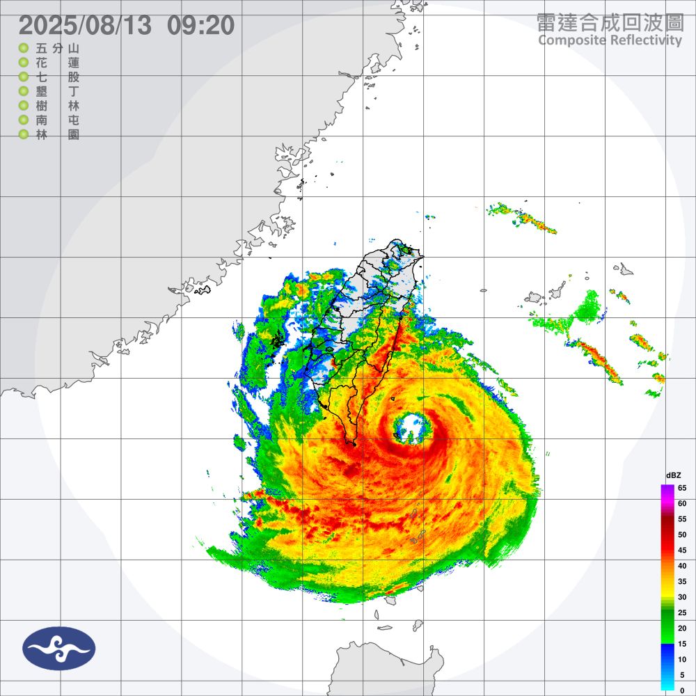
August 13, 2025 at 1:42 AM
Tropical cyclone Podul to make landfall in Taiwan soon