


SamuelG
@cyclovort1.bsky.social
Weather enthusiast, Undergraduate at OU Class of ‘28
I like research
I like research
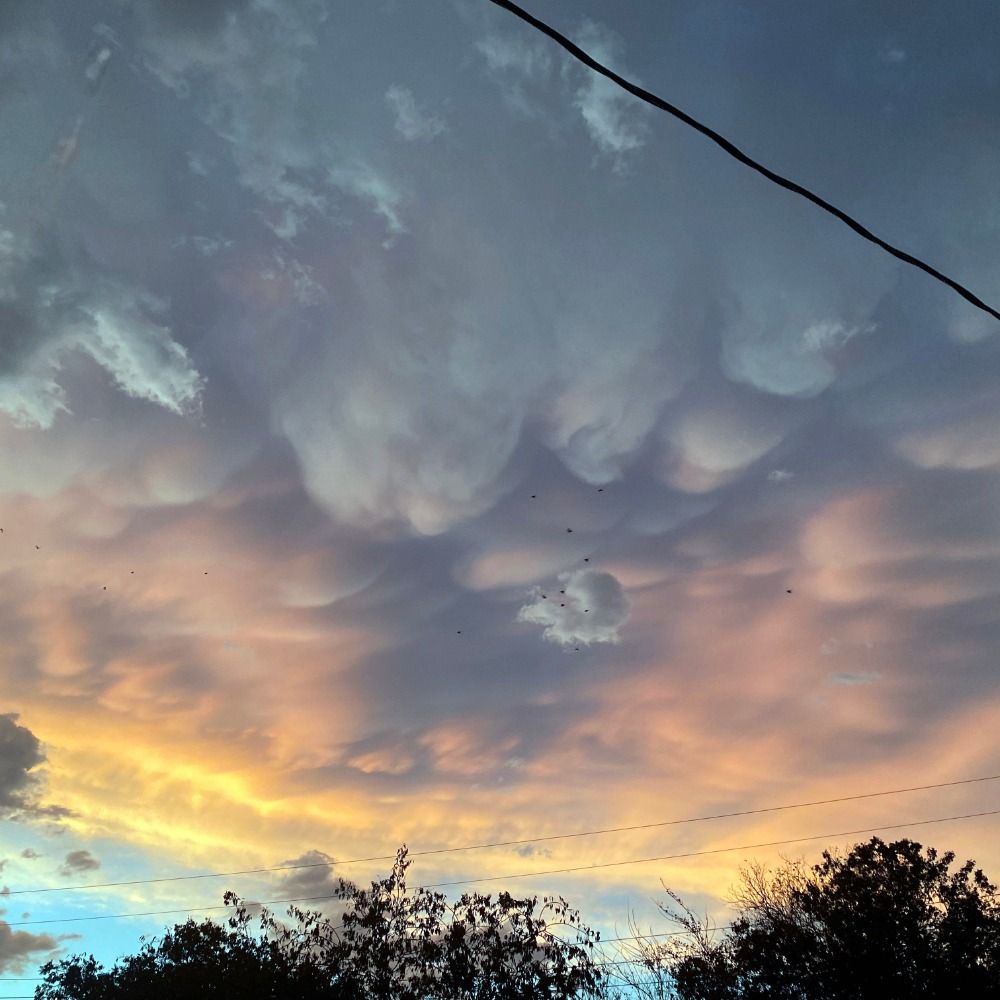
Absolutely perfect MD!
June 4, 2025 at 4:58 AM
Absolutely perfect MD!
At this point, where would we draw a line between a shelf cloud and a wall cloud? A lot of it is semantics really, but interesting topic nonetheless
June 4, 2025 at 4:56 AM
At this point, where would we draw a line between a shelf cloud and a wall cloud? A lot of it is semantics really, but interesting topic nonetheless
Not at all actually, my obsession kicked off before I could even remember(which seems unusual these days?)
June 2, 2025 at 7:53 PM
Not at all actually, my obsession kicked off before I could even remember(which seems unusual these days?)
I’m glad I’m not the only one on this train
April 30, 2025 at 12:56 AM
I’m glad I’m not the only one on this train
The only proper target today
April 22, 2025 at 2:37 PM
The only proper target today
Cold front probably lifted out that warm nose and shear increased rougly to 300m2/s2 0-1SRH!
April 18, 2025 at 2:25 AM
Cold front probably lifted out that warm nose and shear increased rougly to 300m2/s2 0-1SRH!
Now if the MPAS models verify...


March 29, 2025 at 5:49 PM
Now if the MPAS models verify...
Further north and west, closer to the low, weaker mid level winds will be present, yielding for lower SRI and smaller updrafts. Further south and east in the zone with higher winds, stronger SRI and somewhat larger updrafts may develop, leading to potentially stronger tornadoes.
March 18, 2025 at 7:59 PM
Further north and west, closer to the low, weaker mid level winds will be present, yielding for lower SRI and smaller updrafts. Further south and east in the zone with higher winds, stronger SRI and somewhat larger updrafts may develop, leading to potentially stronger tornadoes.
The level of destabilization will depend on the extent of daytime heating in this area. Assuming HRRR is correct, very strong low level instability would develop and bring a pretty decent chance of tornadoes. It is one of the more impressive cold core setups I have seen.
March 18, 2025 at 7:59 PM
The level of destabilization will depend on the extent of daytime heating in this area. Assuming HRRR is correct, very strong low level instability would develop and bring a pretty decent chance of tornadoes. It is one of the more impressive cold core setups I have seen.
Is there a particular reason why HRRR(rather the entire ARW core in general) tends to overmix?
March 13, 2025 at 5:16 AM
Is there a particular reason why HRRR(rather the entire ARW core in general) tends to overmix?
An ensemble breaking a pressure record 6 days out is a feat by itself
March 9, 2025 at 6:36 AM
An ensemble breaking a pressure record 6 days out is a feat by itself
Same energy as NE NE.
March 9, 2025 at 6:35 AM
Same energy as NE NE.
When was the last time all ensembles across the board had such a deep low this far out?
March 7, 2025 at 7:13 PM
When was the last time all ensembles across the board had such a deep low this far out?
No matter what, the consequences are very worrying.
March 6, 2025 at 11:38 PM
No matter what, the consequences are very worrying.
Seeing the cold front interacting with the smoke plume is very interesting!
March 4, 2025 at 1:56 AM
Seeing the cold front interacting with the smoke plume is very interesting!
I believed that without the EML/warm nose on 2/26 being as strong as it was, the tornado threat would have been much weaker. This event is much different since the EML is much weaker and it’s firing after dark and along a NE/SW oriented cold front, so it’s a very difficult forecast.
March 3, 2025 at 5:59 PM
I believed that without the EML/warm nose on 2/26 being as strong as it was, the tornado threat would have been much weaker. This event is much different since the EML is much weaker and it’s firing after dark and along a NE/SW oriented cold front, so it’s a very difficult forecast.
Destabilization may be a concern as the convection fires only 2-3 hours after the prior convection moves through, but given a potent dry slot it should allow for at least some destabilization.
March 2, 2025 at 3:28 AM
Destabilization may be a concern as the convection fires only 2-3 hours after the prior convection moves through, but given a potent dry slot it should allow for at least some destabilization.
I wonder how the ones who release the weather balloons every morning and evening are doing, I’m worried on what is to come
February 28, 2025 at 7:50 PM
I wonder how the ones who release the weather balloons every morning and evening are doing, I’m worried on what is to come
Need more of this kind of energy!
February 28, 2025 at 5:00 PM
Need more of this kind of energy!
May lead to an epic sunset here(hopefully)
February 27, 2025 at 12:06 AM
May lead to an epic sunset here(hopefully)
I feel Waldo is not talked about aa much as it should be. Photogenic rope/wedge, hitting nothing, and with a pretty unique environment
February 24, 2025 at 6:52 AM
I feel Waldo is not talked about aa much as it should be. Photogenic rope/wedge, hitting nothing, and with a pretty unique environment
-very unstable airmass along/near the dryline, yet storms were still having outflow dominance issues. Perhaps it was the somewhat weak low-level shear and/or the almost SSWerly surface winds?


February 22, 2025 at 5:16 AM
-very unstable airmass along/near the dryline, yet storms were still having outflow dominance issues. Perhaps it was the somewhat weak low-level shear and/or the almost SSWerly surface winds?
This only makes me wonder even more why something like May 6 underperformed; my impression this entire time to why May 6 didn't do much was that you needed that very moist airmass right along the dryline, as many large synoptic plains outbreaks have. This one instead had that somewhat dry but-
February 22, 2025 at 5:16 AM
This only makes me wonder even more why something like May 6 underperformed; my impression this entire time to why May 6 didn't do much was that you needed that very moist airmass right along the dryline, as many large synoptic plains outbreaks have. This one instead had that somewhat dry but-