


Corey Thompson
@coreytwx.bsky.social
Meteorologist, KCRG-TV9. Iowan. Hawkeye fan. General giant nerd.
Snowy scenes in Cedar Rapids during the first (and maybe worst?) snowstorm of the year.


November 29, 2025 at 7:57 PM
Snowy scenes in Cedar Rapids during the first (and maybe worst?) snowstorm of the year.
We're still going out there at this hour. This is a cell phone night mode shot directly over my head. My goodness.

November 12, 2025 at 5:00 AM
We're still going out there at this hour. This is a cell phone night mode shot directly over my head. My goodness.
Much more muted in the city center.

November 12, 2025 at 2:38 AM
Much more muted in the city center.
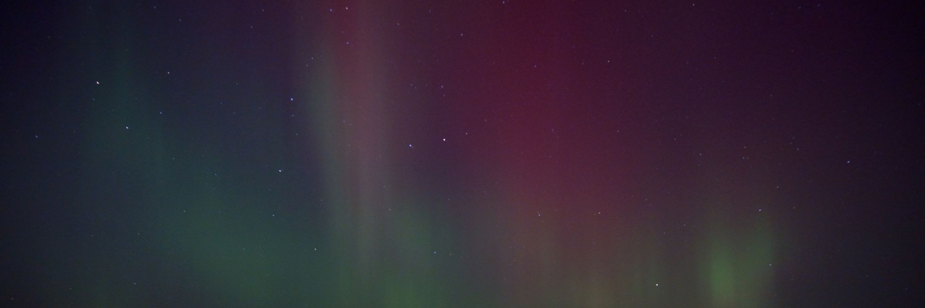
Northern lights are wildly visible within city limits tonight. Colors and all. Big time wow!

November 12, 2025 at 1:40 AM
Northern lights are wildly visible within city limits tonight. Colors and all. Big time wow!
For some reason, I do look my most unhinged when talking about the northern lights on TV:

November 6, 2025 at 11:35 PM
For some reason, I do look my most unhinged when talking about the northern lights on TV:
Melissa is still a monster 24 hours later. It's remarkable how steadily intense it's been.

October 28, 2025 at 3:19 AM
Melissa is still a monster 24 hours later. It's remarkable how steadily intense it's been.
What a monster Melissa is at this hour.

October 27, 2025 at 3:04 AM
What a monster Melissa is at this hour.
There's color to be had out there but it's spotty for the brilliant stuff. Pleasant Creek State Rec Area near Palo.
(Also because life is all about balance, I may have stepped in horse poop while taking this 🙃)
(Also because life is all about balance, I may have stepped in horse poop while taking this 🙃)

October 26, 2025 at 9:03 PM
There's color to be had out there but it's spotty for the brilliant stuff. Pleasant Creek State Rec Area near Palo.
(Also because life is all about balance, I may have stepped in horse poop while taking this 🙃)
(Also because life is all about balance, I may have stepped in horse poop while taking this 🙃)
That's some fall-looking scenery right there:

October 21, 2025 at 10:23 PM
That's some fall-looking scenery right there:
Can't argue with this one, it's just scientific.

October 16, 2025 at 1:55 AM
Can't argue with this one, it's just scientific.
ABC Sports' graphics department in the early to mid 2000s was a little out of control. This wasn't even the most ridiculous example I can remember!
October 16, 2025 at 1:35 AM
ABC Sports' graphics department in the early to mid 2000s was a little out of control. This wasn't even the most ridiculous example I can remember!
Should be a felony.

October 14, 2025 at 4:43 PM
Should be a felony.
It had been a pretty wet late summer/early fall that year, but what really tipped things over the edge into "serious problem" territory was September 21, 2016. A big blob of storms in north-central Iowa produced severe weather, and really extreme rainfall totals (thanks Iowa Environmental Mesonet):

October 4, 2025 at 7:18 PM
It had been a pretty wet late summer/early fall that year, but what really tipped things over the edge into "serious problem" territory was September 21, 2016. A big blob of storms in north-central Iowa produced severe weather, and really extreme rainfall totals (thanks Iowa Environmental Mesonet):
FNL BTS: @jacklido.bsky.social does some more prep for the KCRG 9.2 Game of the Week in-between live hits on KCRG.
I, meanwhile, am standing quietly and sweating.
I, meanwhile, am standing quietly and sweating.

October 3, 2025 at 9:57 PM
FNL BTS: @jacklido.bsky.social does some more prep for the KCRG 9.2 Game of the Week in-between live hits on KCRG.
I, meanwhile, am standing quietly and sweating.
I, meanwhile, am standing quietly and sweating.
Lightning/city illuminated shelf cloud ahead of non-severe storms. They sure are noisy, though! Constant thunder at the moment ahead of the heavier rain.

September 23, 2025 at 3:09 AM
Lightning/city illuminated shelf cloud ahead of non-severe storms. They sure are noisy, though! Constant thunder at the moment ahead of the heavier rain.
How i feel watching Red Zone on Sunday instead of the local broadcasts:

September 14, 2025 at 5:13 PM
How i feel watching Red Zone on Sunday instead of the local broadcasts:

A little slow convection time lapse for you this evening:
August 18, 2025 at 12:54 AM
A little slow convection time lapse for you this evening:
That late evening sun angle really emphasizes the smoke we've got in the region.

August 1, 2025 at 1:03 AM
That late evening sun angle really emphasizes the smoke we've got in the region.
Here's the graphic from the Storm Prediction Center, indicating the potential for a swath of especially damaging winds from northwest Iowa toward central Iowa. There have been some recent 90+ mph gusts reported in far northwest Iowa.

July 29, 2025 at 3:00 AM
Here's the graphic from the Storm Prediction Center, indicating the potential for a swath of especially damaging winds from northwest Iowa toward central Iowa. There have been some recent 90+ mph gusts reported in far northwest Iowa.
Lighting becoming more dramatic!

July 23, 2025 at 1:10 AM
Lighting becoming more dramatic!
What's left of a tornado-warned storm from about 3 hours ago, currently passing northwest of Cedar Falls. Kinda cute.

July 23, 2025 at 1:03 AM
What's left of a tornado-warned storm from about 3 hours ago, currently passing northwest of Cedar Falls. Kinda cute.
Meanwhile, blue sky puffy clouds like an artist drew it up.

July 4, 2025 at 6:36 PM
Meanwhile, blue sky puffy clouds like an artist drew it up.
Always love an interesting sky.

July 4, 2025 at 1:44 AM
Always love an interesting sky.
Dutiful storm spotter in the Amana Colonies.

June 18, 2025 at 9:42 PM
Dutiful storm spotter in the Amana Colonies.