


Next Monday has the look of an event that could be extremely significant. Strong dynamics coupled with sufficient instability… something to monitor closely over the course of the next few days.

April 22, 2025 at 10:42 PM
Next Monday has the look of an event that could be extremely significant. Strong dynamics coupled with sufficient instability… something to monitor closely over the course of the next few days.
Not to get too ahead of ourselves, but early April looks to be quite active…

March 27, 2025 at 1:32 AM
Not to get too ahead of ourselves, but early April looks to be quite active…
Regarding severe potential for next Sunday: While mesoscale features are very uncertain, worth noting global models indicating a region of strong CAPE and significant veering winds ahead of the shortwave.
Fields plotted with @aguacerowx.bsky.social which is great for overlap of parameters.
Fields plotted with @aguacerowx.bsky.social which is great for overlap of parameters.

March 25, 2025 at 2:58 PM
Regarding severe potential for next Sunday: While mesoscale features are very uncertain, worth noting global models indicating a region of strong CAPE and significant veering winds ahead of the shortwave.
Fields plotted with @aguacerowx.bsky.social which is great for overlap of parameters.
Fields plotted with @aguacerowx.bsky.social which is great for overlap of parameters.
Reposted by Cris Kubatko

Probability of at least a 'Slight Risk' for Sunday, March 30th from this fascinating NSSL severe convection ML probability model. apps.nssl.noaa.gov/s2s-severe/f...

March 25, 2025 at 2:03 PM
Probability of at least a 'Slight Risk' for Sunday, March 30th from this fascinating NSSL severe convection ML probability model. apps.nssl.noaa.gov/s2s-severe/f...
Monitoring the potential for snow squalls in central Ohio early Thursday morning. With marginal values of 0-3 km CAPE and some moisture return coming from northwesterly winds off Lake Michigan, we could see some bursts of snow Thursday morning.


November 20, 2024 at 1:55 AM
Monitoring the potential for snow squalls in central Ohio early Thursday morning. With marginal values of 0-3 km CAPE and some moisture return coming from northwesterly winds off Lake Michigan, we could see some bursts of snow Thursday morning.
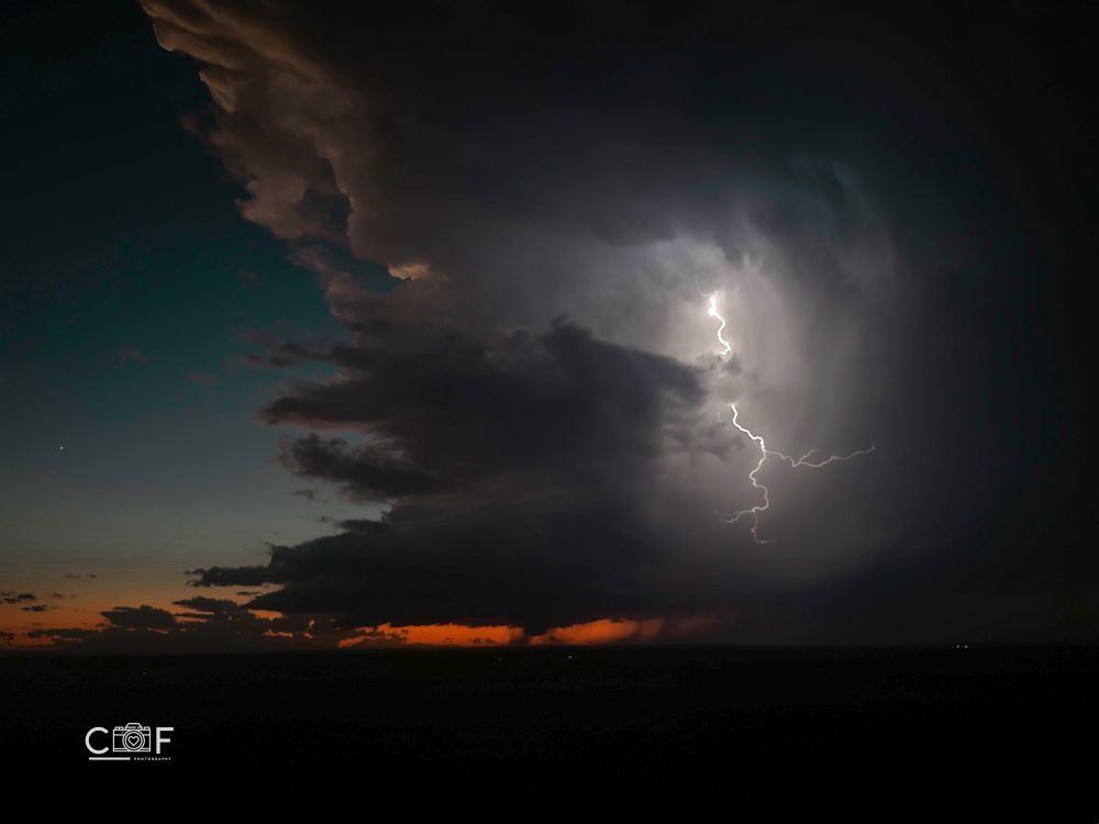
Reposted by Cris Kubatko
However many times this was on your feed today, it wasn’t enough. Absolute perfection.
November 20, 2024 at 12:43 AM
However many times this was on your feed today, it wasn’t enough. Absolute perfection.
Reposted by Cris Kubatko

*Not a Forecast*
Ain’t one for posting mdls but when a 933mb low shows up, well, you gotta share.
For ref Cat5 Hurricane Beryl bottomed out @ 934mb & had winds to 165 mph (270 km/h).
While not likely to reach that, it is gonna be an impactful low - how much? we’ll see!
#BCwx #BCstorm #BCstormwatch
Ain’t one for posting mdls but when a 933mb low shows up, well, you gotta share.
For ref Cat5 Hurricane Beryl bottomed out @ 934mb & had winds to 165 mph (270 km/h).
While not likely to reach that, it is gonna be an impactful low - how much? we’ll see!
#BCwx #BCstorm #BCstormwatch
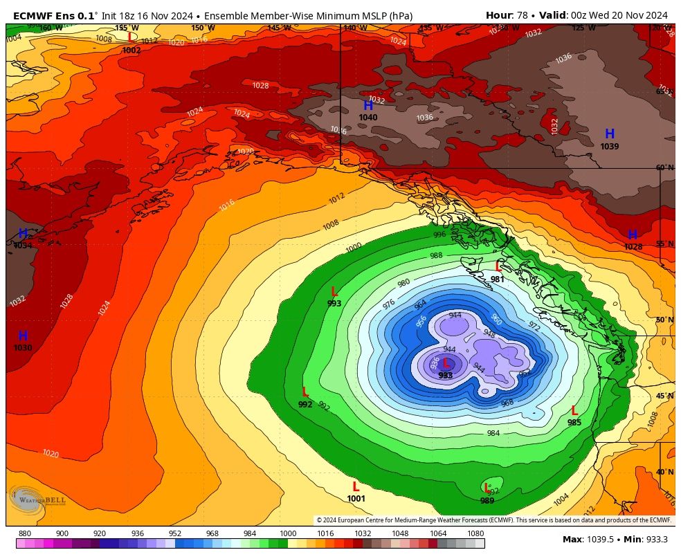
November 17, 2024 at 12:52 AM
*Not a Forecast*
Ain’t one for posting mdls but when a 933mb low shows up, well, you gotta share.
For ref Cat5 Hurricane Beryl bottomed out @ 934mb & had winds to 165 mph (270 km/h).
While not likely to reach that, it is gonna be an impactful low - how much? we’ll see!
#BCwx #BCstorm #BCstormwatch
Ain’t one for posting mdls but when a 933mb low shows up, well, you gotta share.
For ref Cat5 Hurricane Beryl bottomed out @ 934mb & had winds to 165 mph (270 km/h).
While not likely to reach that, it is gonna be an impactful low - how much? we’ll see!
#BCwx #BCstorm #BCstormwatch
Eyeing the potential for the first measurable snow for parts of the Great Lakes and Ohio Valley Wednesday-Thursday of next week. An inverted thermodynamic profile with warmer air to the north and colder air to the south is pretty rare in the NH. Could be a pretty neat storm, but lots of uncertainty.


November 17, 2024 at 12:00 AM
Eyeing the potential for the first measurable snow for parts of the Great Lakes and Ohio Valley Wednesday-Thursday of next week. An inverted thermodynamic profile with warmer air to the north and colder air to the south is pretty rare in the NH. Could be a pretty neat storm, but lots of uncertainty.
Some of these model outputs for hodographs tomorrow night are… concerning to say the least.

October 30, 2024 at 1:43 AM
Some of these model outputs for hodographs tomorrow night are… concerning to say the least.
Reposted by Cris Kubatko

October 29, 2024 at 7:08 PM
Reposted by Cris Kubatko
Tomorrow there is an upcoming severe weather threat - lets talk about that!
The setup is mainly tornado driven with a 10# hatched area, followed by a wind threat later in the afternoon. This thread will explain what drives these storms, as well as possibles "ifs" about the setup.
The setup is mainly tornado driven with a 10# hatched area, followed by a wind threat later in the afternoon. This thread will explain what drives these storms, as well as possibles "ifs" about the setup.


October 29, 2024 at 7:56 PM
Tomorrow there is an upcoming severe weather threat - lets talk about that!
The setup is mainly tornado driven with a 10# hatched area, followed by a wind threat later in the afternoon. This thread will explain what drives these storms, as well as possibles "ifs" about the setup.
The setup is mainly tornado driven with a 10# hatched area, followed by a wind threat later in the afternoon. This thread will explain what drives these storms, as well as possibles "ifs" about the setup.
Reposted by Cris Kubatko

Large storm-relative wind & streamwise vorticity in the lowest 1km, juxtaposed with an unstable air mass over the southern plains should support a supercell and tornado risk tomorrow evening.
Failure modes are generally focused on the ability for cellular CI to remain cellular & somewhat discrete.
Failure modes are generally focused on the ability for cellular CI to remain cellular & somewhat discrete.

October 29, 2024 at 9:49 PM
Large storm-relative wind & streamwise vorticity in the lowest 1km, juxtaposed with an unstable air mass over the southern plains should support a supercell and tornado risk tomorrow evening.
Failure modes are generally focused on the ability for cellular CI to remain cellular & somewhat discrete.
Failure modes are generally focused on the ability for cellular CI to remain cellular & somewhat discrete.
Tomorrow’s severe threat over the Plains has much of our attention, and rightfully so, however, models are beginning to come into agreement on another potent upper level trough with strong southwesterly flow late this weekend and early next week. Something to keep an eye on.


October 30, 2024 at 1:37 AM
Tomorrow’s severe threat over the Plains has much of our attention, and rightfully so, however, models are beginning to come into agreement on another potent upper level trough with strong southwesterly flow late this weekend and early next week. Something to keep an eye on.
Reposted by Cris Kubatko

Something to note with today's severe and tornado chances, I am noticing the wind field remains rather veered in the warm sector. One would expect more inward crossing isobars with the surface wind field. This will likely lead to a reduced tornado chance, directly underneath the low.


October 21, 2024 at 8:43 PM
Something to note with today's severe and tornado chances, I am noticing the wind field remains rather veered in the warm sector. One would expect more inward crossing isobars with the surface wind field. This will likely lead to a reduced tornado chance, directly underneath the low.
Reposted by Cris Kubatko

Beginning to see robust storms going up on the leading edge of a dryline in N Kansas and into southern Nebraska!
These storms will have the possibility to produce a few highly photogenic tornadoes as well as small hail as they push into a more favorable environment.
These storms will have the possibility to produce a few highly photogenic tornadoes as well as small hail as they push into a more favorable environment.

October 21, 2024 at 7:56 PM
Beginning to see robust storms going up on the leading edge of a dryline in N Kansas and into southern Nebraska!
These storms will have the possibility to produce a few highly photogenic tornadoes as well as small hail as they push into a more favorable environment.
These storms will have the possibility to produce a few highly photogenic tornadoes as well as small hail as they push into a more favorable environment.
Reposted by Cris Kubatko

September #Arctic sea ice extent since 1850 - comparison now updated through 2024
Please note that the reconstruction (SIBT1850) is for the 15th of September, while the NSIDC is a monthly mean. You can read more about this data set at carbonbrief.org/guest-post-p....
Please note that the reconstruction (SIBT1850) is for the 15th of September, while the NSIDC is a monthly mean. You can read more about this data set at carbonbrief.org/guest-post-p....

October 20, 2024 at 9:19 PM
September #Arctic sea ice extent since 1850 - comparison now updated through 2024
Please note that the reconstruction (SIBT1850) is for the 15th of September, while the NSIDC is a monthly mean. You can read more about this data set at carbonbrief.org/guest-post-p....
Please note that the reconstruction (SIBT1850) is for the 15th of September, while the NSIDC is a monthly mean. You can read more about this data set at carbonbrief.org/guest-post-p....
Solid ensemble signal for a potential stretch of severe weather in the 6-12 day range. With potent troughing in the west and ridging in the east, sufficient warmth coupled with adequate moisture returns should exist in the Plains. Something to monitor.


October 21, 2024 at 1:12 AM
Solid ensemble signal for a potential stretch of severe weather in the 6-12 day range. With potent troughing in the west and ridging in the east, sufficient warmth coupled with adequate moisture returns should exist in the Plains. Something to monitor.
Hello everyone! My name is Cris and I am an atmospheric science student at Ohio State. I am super passionate about weather in its entirety, but winter weather is probably what interests me the most. It seems like a great community here on BlueSky and I look forward to learning from you all!!
October 20, 2024 at 11:09 PM
Hello everyone! My name is Cris and I am an atmospheric science student at Ohio State. I am super passionate about weather in its entirety, but winter weather is probably what interests me the most. It seems like a great community here on BlueSky and I look forward to learning from you all!!