


Charleston Weather
@chswx.com
Weather forecasts and alerts for the Charleston, SC metro area (Berkeley/Charleston/Dorchester counties), first popularized on Twitter by @jaredwsmith.com.
⛈️ https://chswx.com
🐘 https://chswx.social/@chswx
⛈️ https://chswx.com
🐘 https://chswx.social/@chswx
Showers and storms continue to press eastward toward the coast, and are producing a bit more lightning as they do so. Brief heavy downpours possible as this line moves on by over the next hour.

November 10, 2025 at 3:07 AM
Showers and storms continue to press eastward toward the coast, and are producing a bit more lightning as they do so. Brief heavy downpours possible as this line moves on by over the next hour.
Showers and a few thunderstorms precede a strong cold front that will sweep through later tonight, ushering in an Arctic intrusion that brings about our first freeze Monday night/Tuesday morning.

November 10, 2025 at 2:16 AM
Showers and a few thunderstorms precede a strong cold front that will sweep through later tonight, ushering in an Arctic intrusion that brings about our first freeze Monday night/Tuesday morning.
Showers and a few thunderstorms are moving into the area from the southwest. Be ready for brief periods of heavy rain through this evening.

November 8, 2025 at 6:42 PM
Showers and a few thunderstorms are moving into the area from the southwest. Be ready for brief periods of heavy rain through this evening.
We do have a couple shots at a few showers this afternoon and into tonight as a cold front moves into the area, but they’ll be on a weakening trend so rain is not guaranteed. Better rain chances the closer to I-95 you are.

October 19, 2025 at 4:08 PM
We do have a couple shots at a few showers this afternoon and into tonight as a cold front moves into the area, but they’ll be on a weakening trend so rain is not guaranteed. Better rain chances the closer to I-95 you are.
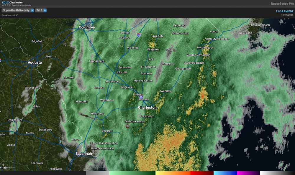
Light to moderate rain continues across the area this morning as well. Rain rates don’t look severe enough to cause more widespread flooding issues, but any rain on top certainly doesn’t help as water levels progress into moderate flood.
October 11, 2025 at 3:19 PM
Light to moderate rain continues across the area this morning as well. Rain rates don’t look severe enough to cause more widespread flooding issues, but any rain on top certainly doesn’t help as water levels progress into moderate flood.
Charleston Harbor is back into flood stage on the way to potentially another 8’ tide just around noon. Be ready to reroute around road closures downtown and in parts of Mt. Pleasant especially on Long Point near Snee Farm.

October 11, 2025 at 2:38 PM
Charleston Harbor is back into flood stage on the way to potentially another 8’ tide just around noon. Be ready to reroute around road closures downtown and in parts of Mt. Pleasant especially on Long Point near Snee Farm.
Major coastal flooding is underway with numerous road closures being reported in downtown Charleston. Water levels should continue to rise even past the time of predicted high tide and look to peak in the 8.3-8.5’ MLLW range.

October 10, 2025 at 3:02 PM
Major coastal flooding is underway with numerous road closures being reported in downtown Charleston. Water levels should continue to rise even past the time of predicted high tide and look to peak in the 8.3-8.5’ MLLW range.
Moderate coastal flooding is underway and we should begin to see roads close soon (if they haven’t already). Should reach major flood stage within the hour. Coastal flooding will continue through at least 1 PM.

October 10, 2025 at 2:11 PM
Moderate coastal flooding is underway and we should begin to see roads close soon (if they haven’t already). Should reach major flood stage within the hour. Coastal flooding will continue through at least 1 PM.
Road closures have begun as water levels in the harbor head into moderate flood stage (though right now we might not reach major flood). Heed all closures and never go around barricades!
October 9, 2025 at 1:43 PM
Road closures have begun as water levels in the harbor head into moderate flood stage (though right now we might not reach major flood). Heed all closures and never go around barricades!
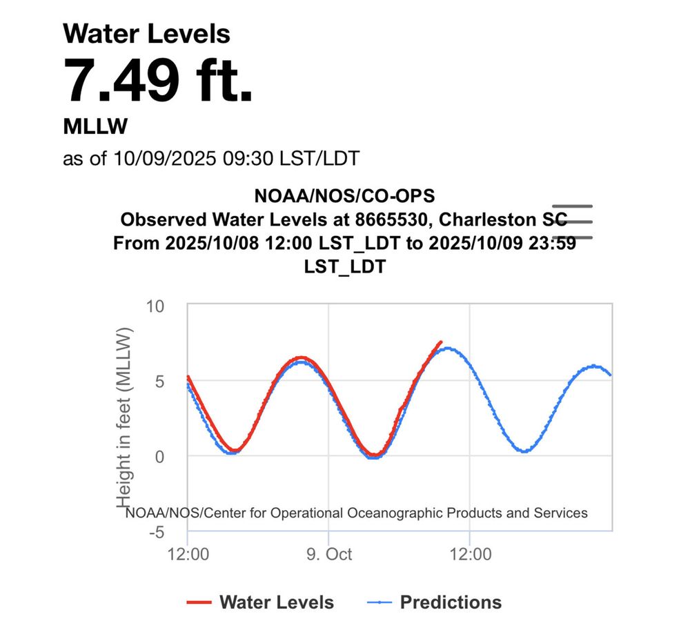
The front is through, but rain continues across the area this morning and could hang around a bit longer. Complicating matters, of course, will be the very high tide; the Coastal Flood Warning goes into effect at 8am.

October 9, 2025 at 11:32 AM
The front is through, but rain continues across the area this morning and could hang around a bit longer. Complicating matters, of course, will be the very high tide; the Coastal Flood Warning goes into effect at 8am.
Showers and a few thunderstorms continue to sink southward across the area this evening. Brief downpours possible. Big changes arrive behind the front overnight, with much cooler temperatures expected Thursday.

October 9, 2025 at 12:24 AM
Showers and a few thunderstorms continue to sink southward across the area this evening. Brief downpours possible. Big changes arrive behind the front overnight, with much cooler temperatures expected Thursday.
Showers and a few thunderstorms are developing and sinking south and eastward across the area. Brief downpours are possible.

October 8, 2025 at 9:54 PM
Showers and a few thunderstorms are developing and sinking south and eastward across the area. Brief downpours are possible.
Water levels are peaking right in the neighborhood of the moderate flooding threshold. Be ready to route around flooded or closed roads through mid-morning.

October 7, 2025 at 12:31 PM
Water levels are peaking right in the neighborhood of the moderate flooding threshold. Be ready to route around flooded or closed roads through mid-morning.
Showers are streaming ashore this morning with some generally light to moderate rain. We could use a little bit of this, and it’s nice to not get too much of a good thing all at once, either.

October 6, 2025 at 12:42 PM
Showers are streaming ashore this morning with some generally light to moderate rain. We could use a little bit of this, and it’s nice to not get too much of a good thing all at once, either.
Water levels in Charleston Harbor are back into minor flood stage this morning. We’ve also got some rain in the area; be ready to reroute around closed roads.

October 6, 2025 at 11:15 AM
Water levels in Charleston Harbor are back into minor flood stage this morning. We’ve also got some rain in the area; be ready to reroute around closed roads.
Usually we have to get a super nasty storm to get a payoff like this. Always wonderful when we can just get the sunset.

September 29, 2025 at 11:15 PM
Usually we have to get a super nasty storm to get a payoff like this. Always wonderful when we can just get the sunset.
Unbelievably brilliant rainbow west of the Ashley right now!

September 29, 2025 at 10:59 PM
Unbelievably brilliant rainbow west of the Ashley right now!
Nine/Imelda will still influence our weather next week, but impacts will be more indirect. We can still expect some bouts of heavy rain Monday & Tuesday, gusty NE winds that will drive salt water flooding at times of high tide, and rough marine conditions.

September 28, 2025 at 4:24 PM
Nine/Imelda will still influence our weather next week, but impacts will be more indirect. We can still expect some bouts of heavy rain Monday & Tuesday, gusty NE winds that will drive salt water flooding at times of high tide, and rough marine conditions.
Confidence continues to increase in the sharp right turn out to sea for future Imelda by midweek, which is excellent news for our neck of the woods. Still, the feed of moisture around the storm will interact with a stalled front near the coast to bring some heavy rain at times.

September 28, 2025 at 3:10 PM
Confidence continues to increase in the sharp right turn out to sea for future Imelda by midweek, which is excellent news for our neck of the woods. Still, the feed of moisture around the storm will interact with a stalled front near the coast to bring some heavy rain at times.
Nine is now officially a Tropical Depression after Hurricane Hunters found a low-level center. It is forecast to become a tropical storm tonight; the next name is Imelda. While risk for direct landfall is decreasing, rain and coastal impacts remain in play.

September 27, 2025 at 3:07 PM
Nine is now officially a Tropical Depression after Hurricane Hunters found a low-level center. It is forecast to become a tropical storm tonight; the next name is Imelda. While risk for direct landfall is decreasing, rain and coastal impacts remain in play.
The NHC forecast continues to point to a stalling scenario off our coast for Nine/future Imelda by mid-week. Model trends have increasingly favored the storm being pulled out to sea by a stronger Humberto. However, rain and wind impacts continue to appear likely.

September 27, 2025 at 12:49 PM
The NHC forecast continues to point to a stalling scenario off our coast for Nine/future Imelda by mid-week. Model trends have increasingly favored the storm being pulled out to sea by a stronger Humberto. However, rain and wind impacts continue to appear likely.
The 11PM advisory on PTC Nine continues to show a stalling tropical storm/low-end hurricane off the central SC coast by Tuesday. Model trends today have been increasingly in favor of the offshore stall; certainly something to watch. More tweaks to come.

September 27, 2025 at 3:22 AM
The 11PM advisory on PTC Nine continues to show a stalling tropical storm/low-end hurricane off the central SC coast by Tuesday. Model trends today have been increasingly in favor of the offshore stall; certainly something to watch. More tweaks to come.
Showers and thunderstorms along the I-95 corridor have kicked out some outflow that is starting to ignite more storms further eastward across Berkeley and Charleston counties. Expect some rain overnight with a soggy-at-times Saturday.

September 27, 2025 at 1:55 AM
Showers and thunderstorms along the I-95 corridor have kicked out some outflow that is starting to ignite more storms further eastward across Berkeley and Charleston counties. Expect some rain overnight with a soggy-at-times Saturday.
The first track from NHC for PTC Nine, which is likely to become Imelda, indicates the storm approaching the coast next week and slowing down, which would drive the flood threat higher. Much uncertainty remains, and this track will be refined. Monitor forecast updates this weekend!

September 26, 2025 at 9:29 PM
The first track from NHC for PTC Nine, which is likely to become Imelda, indicates the storm approaching the coast next week and slowing down, which would drive the flood threat higher. Much uncertainty remains, and this track will be refined. Monitor forecast updates this weekend!
Closer to home, the seabreeze is starting to get a little active as temperatures warm into the upper 80s away from the immediate coast. A front will approach later tonight, increasing the risk for showers and storms, some of which may contain heavy rain.

September 26, 2025 at 5:38 PM
Closer to home, the seabreeze is starting to get a little active as temperatures warm into the upper 80s away from the immediate coast. A front will approach later tonight, increasing the risk for showers and storms, some of which may contain heavy rain.