


Charleston Weather
@chswx.com
Weather forecasts and alerts for the Charleston, SC metro area (Berkeley/Charleston/Dorchester counties), first popularized on Twitter by @jaredwsmith.com.
⛈️ https://chswx.com
🐘 https://chswx.social/@chswx
⛈️ https://chswx.com
🐘 https://chswx.social/@chswx
Pinned
Charleston Weather
@chswx.com
· Jul 8

Now that Bluesky’s added per-account notifications, you can now get your weather information pushed to you on demand whenever I post. One less reason to hang around over *there!*
The Coastal Flood Advisory for Charleston County has been cancelled.
December 2, 2025 at 11:07 AM
The Coastal Flood Advisory for Charleston County has been cancelled.
The Coastal Flood Advisory for Charleston County continues until 7 AM.
December 2, 2025 at 9:26 AM
The Coastal Flood Advisory for Charleston County continues until 7 AM.
Coastal Flood Advisory for Charleston County will be in effect today from 3 AM until 7 AM.
December 2, 2025 at 5:32 AM
Coastal Flood Advisory for Charleston County will be in effect today from 3 AM until 7 AM.
Coastal Flood Advisory for Charleston County goes into effect tomorrow from 3 AM until 7 AM.
December 2, 2025 at 2:19 AM
Coastal Flood Advisory for Charleston County goes into effect tomorrow from 3 AM until 7 AM.
Much-needed rain and below-normal temperatures are in store for the week ahead as a series of fronts affect the area. We’ll also see the risk for some tidal flooding in the mornings beginning Tuesday.

The week ahead: Temperatures generally below normal with some much-needed rain in store
Much-needed rain and below-normal temperatures are in store for the week ahead as a series of fronts affect the area. We’ll also see the risk for some tidal flooding in the mornings beginning Tuesday courtesy of the upcoming full moon.
chswx.com
November 30, 2025 at 10:51 PM
Much-needed rain and below-normal temperatures are in store for the week ahead as a series of fronts affect the area. We’ll also see the risk for some tidal flooding in the mornings beginning Tuesday.
Front incoming…60s and 70s ahead of it, while the Upstate isn’t getting out of the 40s today!

November 30, 2025 at 6:18 PM
Front incoming…60s and 70s ahead of it, while the Upstate isn’t getting out of the 40s today!
Well, we made it: Today marks the last day of the 2025 hurricane season.
November 30, 2025 at 2:07 PM
Well, we made it: Today marks the last day of the 2025 hurricane season.
Expect a quiet weekend of weather, with a chilly Saturday before a warmer Sunday to close out November.

Weekend forecast: Chilly Saturday, warmer Sunday
Overall, expect generally quiet weather to continue this weekend, though Saturday will get off to a very chilly start. Expect another morning around or below freezing across much of the area away from the locally warmer coastline, with breezy northeasterly winds making it feel more like the mid-20s. We'll only warm to the mid-50s in the afternoon with partly cloudy to mostly sunny skies expected.
chswx.com
November 28, 2025 at 10:35 PM
Expect a quiet weekend of weather, with a chilly Saturday before a warmer Sunday to close out November.
Cooler air will arrive for Thanksgiving, with highs just peaking around 60° tomorrow. Even colder weather is expected Friday and Saturday, with some frost and freeze concerns, before we warm up ahead of the next storm system on Sunday.

Thanksgiving: Break out the sweaters
One front has come through as of this writing Wednesday evening, with another front hot on its heels to pass through overnight into early Thanksgiving morning. This second front is going to bring in quite the cooldown for the next few days, especially as we get into Friday and Saturday, but Thanksgiving will certainly illustrate the contrast from the past few days: expect lows in the mid-40s to warm to just about 60° in the afternoon, which is just a hair warmer than Wednesday's morning low!
chswx.com
November 27, 2025 at 2:58 AM
Cooler air will arrive for Thanksgiving, with highs just peaking around 60° tomorrow. Even colder weather is expected Friday and Saturday, with some frost and freeze concerns, before we warm up ahead of the next storm system on Sunday.
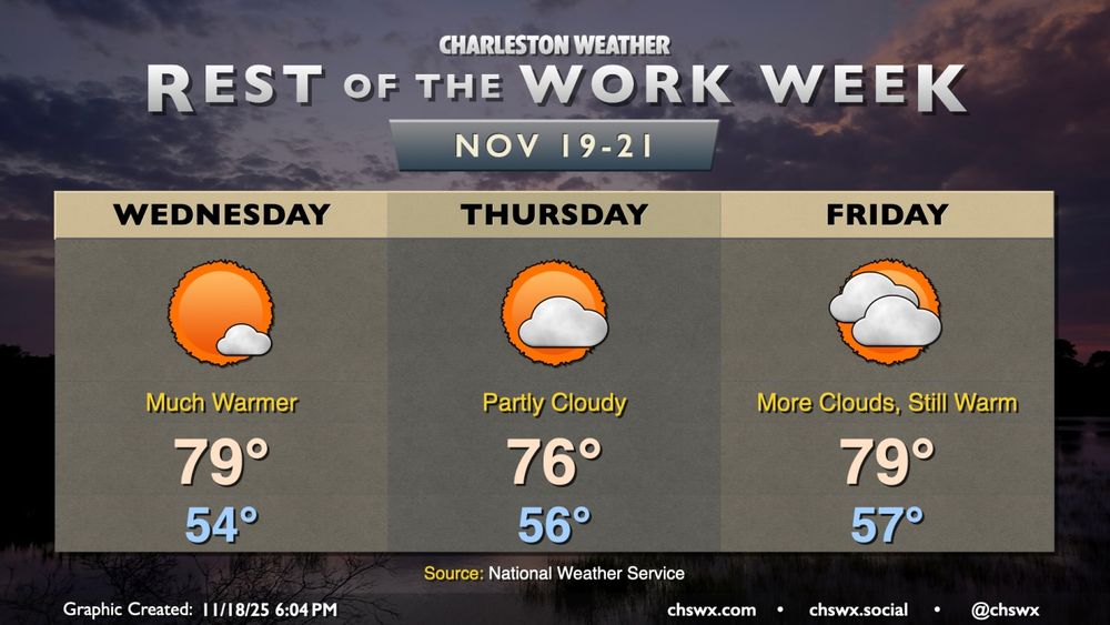
A cold front will come through on Wednesday, bringing a few showers during the day before temperatures get taken down a few pegs just in time for Thanksgiving.

Rest of the week: Turning much cooler
A cold front will come through Wednesday, knocking temperatures down for Thanksgiving and Black Friday.
chswx.com
November 26, 2025 at 3:25 AM
A cold front will come through on Wednesday, bringing a few showers during the day before temperatures get taken down a few pegs just in time for Thanksgiving.
Showers are approaching from the south and should impact at least some of us, especially closer to the coast, over the next few hours. Nothing too out of bounds here but a brief downpour is possible. Watch for slick roads.

November 25, 2025 at 2:10 PM
Showers are approaching from the south and should impact at least some of us, especially closer to the coast, over the next few hours. Nothing too out of bounds here but a brief downpour is possible. Watch for slick roads.
High pressure will depart on Tuesday, allowing a warm front to move northward and bring more warm and humid air with a chance of a few showers. A Wednesday evening front brings us much more seasonally-appropriate weather just in time for Thanksgiving, though.
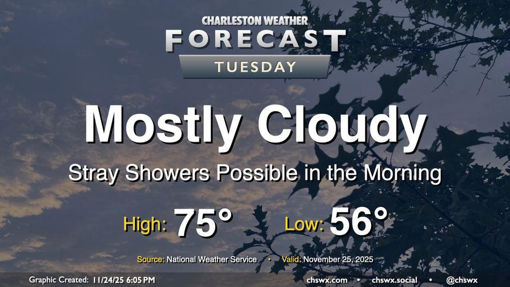
Tuesday: More clouds, maybe a shower
High pressure to our north will be shifting offshore as Tuesday goes on ahead of a storm system moving through the Ohio Valley, allowing a warm front to push northward into the area during the day. Some of us may see a few showers as this warm front moves northward, especially later in the morning and closer to the coast. They'll be relatively short-lived, clearing the area during the afternoon, and won't amount to too terribly much rain for those who see any of it at all.
chswx.com
November 24, 2025 at 11:46 PM
High pressure will depart on Tuesday, allowing a warm front to move northward and bring more warm and humid air with a chance of a few showers. A Wednesday evening front brings us much more seasonally-appropriate weather just in time for Thanksgiving, though.
We'll start Thanksgiving week out on an unseasonably warm note, but a temperature correction is incoming starting Thanksgiving Day as a strong cold front moves by. We'll have a couple more slight rain chances, but overall, we'll be largely dry.

The week ahead: A few more warm days, then cooling back off for Thanksgiving
We'll start Thanksgiving week out on an unseasonably warm note, but a temperature correction is incoming starting Thanksgiving Day as a strong cold front moves by. We'll have a couple more slight rain chances, but overall, we'll be largely dry as drought conditions continue to creep further into the Lowcountry.
chswx.com
November 24, 2025 at 3:29 AM
We'll start Thanksgiving week out on an unseasonably warm note, but a temperature correction is incoming starting Thanksgiving Day as a strong cold front moves by. We'll have a couple more slight rain chances, but overall, we'll be largely dry.
Another warmer-than-normal weekend lies ahead, though a front will restore at least a little order to temperatures for Sunday. We stay on the warm side of normal through next Wednesday before a front cools us off just in time for Thanksgiving.

Weekend forecast: Front restores some order to temperatures Sunday
Another warmer-than-normal weekend lies ahead, though a front will restore at least a little order to temperatures for Sunday. First, though, a very mild Saturday lies ahead, with temperatures starting in the upper 50s, warming to the upper 70s to around 80° in the afternoon. A stray shower will be possible well inland, but the front will be generally making a dry passage overnight into early Sunday morning.
chswx.com
November 22, 2025 at 1:23 AM
Another warmer-than-normal weekend lies ahead, though a front will restore at least a little order to temperatures for Sunday. We stay on the warm side of normal through next Wednesday before a front cools us off just in time for Thanksgiving.
We’ve got a couple more unseasonably warm days in store before a cold front restores some order to temperatures for Sunday. Rain-free conditions look to continue, with the next substantial rain chance for next Wednesday.

Friday & the weekend: A couple more warm days before a brief cooldown
After a slightly cooler and more cloudy day courtesy of a backdoor cold front, temperatures will head back into the upper 70s on Friday as the aforementioned front washes out with high pressure moving offshore. We start the day in the mid-50s and perhaps with some fog. Cloud cover will gradually diminish as the day goes on, and we should have a pleasant close to the day as we head into the weekend.
chswx.com
November 20, 2025 at 11:25 PM
We’ve got a couple more unseasonably warm days in store before a cold front restores some order to temperatures for Sunday. Rain-free conditions look to continue, with the next substantial rain chance for next Wednesday.
Warm temperatures continue for Thursday, though a nearby front and some more cloud cover will likely preclude temperatures from getting too out of hand. We stay warmer than normal heading into the weekend, with a slight cooldown due to a front on Sunday.

Thursday: Slightly cooler, but warming back up Friday
Warm temperatures continue for Thursday, though a nearby front and some more cloud cover will likely preclude temperatures from getting too out of hand. Wednesday's highs were close to records for the date: 82° at the airport was just a degree shy of the record of 83° set in 1942, while 80° downtown missed the record of 82° set there in 1958.
chswx.com
November 20, 2025 at 12:15 AM
Warm temperatures continue for Thursday, though a nearby front and some more cloud cover will likely preclude temperatures from getting too out of hand. We stay warmer than normal heading into the weekend, with a slight cooldown due to a front on Sunday.
The high of 82° today missed the record high by one degree — 83°, set in 1942.
November 19, 2025 at 10:45 PM
The high of 82° today missed the record high by one degree — 83°, set in 1942.
Sharply warmer temperatures are expected starting Wednesday as high pressure ridges in aloft. Expect highs in the upper 70s to low 80s, especially the further south you are.
Rest of the work week: Temperatures head well above normal
The main weather story for the rest of the work week will be unseasonable warmth courtesy of a ridge building in aloft. Temperatures will run well above normal, with highs approaching 80° particularly Wednesday and Friday (and maybe Thursday, depending on the position of a cold front to the north).
chswx.com
November 18, 2025 at 11:51 PM
Sharply warmer temperatures are expected starting Wednesday as high pressure ridges in aloft. Expect highs in the upper 70s to low 80s, especially the further south you are.
Temperatures will run slightly warmer on Tuesday, though still within striking distance of normal. This changes starting Wednesday, as high pressure at the surface and aloft drives highs near 80°, especially Thursday and Friday.
Tuesday: One more day of seasonable temperatures before warmth returns
After a near-normal day of temperatures on Monday, we'll look for a similar performance on Tuesday. Temperatures will start in the mid-40s across much of the area (a little warmer near the coast, a little cooler further inland), and highs will peak around 70° in the afternoon with mostly sunny skies remaining the rule. Winds will be going more southerly during the day as surface high pressure begins to shift offshore.
chswx.com
November 18, 2025 at 12:00 AM
Temperatures will run slightly warmer on Tuesday, though still within striking distance of normal. This changes starting Wednesday, as high pressure at the surface and aloft drives highs near 80°, especially Thursday and Friday.
After a cold front brings a brief cooldown to the area on Monday, temperatures return to the 70s on Tuesday before heading well above normal for the balance of the week ahead with little rain in sight.
The week ahead: Unseasonably warm temperatures develop with little rain in sight
After a cold front brings a brief cooldown to the area on Monday, temperatures return to the 70s on Tuesday before heading well above normal for the balance of the week ahead with little rain in sight.
chswx.com
November 17, 2025 at 4:20 AM
After a cold front brings a brief cooldown to the area on Monday, temperatures return to the 70s on Tuesday before heading well above normal for the balance of the week ahead with little rain in sight.
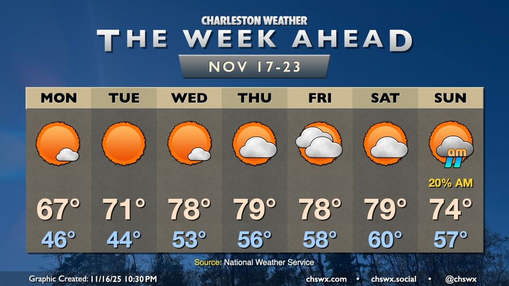
After a brief cooldown on Friday, temperatures head back above normal for the weekend as high pressure remains the dominant weather feature across the area.

Weekend forecast: Warm and quiet weather continues
After a brief cooldown on Friday, temperatures head back above normal for the weekend as high pressure remains the dominant weather feature across the area. We'll see the high that's overhead as of Friday evening slip southward, sending wind directions a little more westerly to southwesterly, kicking temperatures back into the low-to-mid-70s on Saturday. Compressional heating ahead of an advancing cold front will send highs on Sunday solidly into the mid-70s after a warmer start in the mid-50s.
chswx.com
November 15, 2025 at 1:26 AM
After a brief cooldown on Friday, temperatures head back above normal for the weekend as high pressure remains the dominant weather feature across the area.
Quiet weather continues for Friday and the weekend as reinforcing high pressure arrives overnight into tomorrow.

Friday & the weekend: Quiet weather continues
Quiet weather continues for Friday and the weekend as reinforcing high pressure arrives overnight. Friday will feel a touch cooler than Thursday did, with winds going back around to the north in the wake of a dry cold front. Lows Friday bottom out in the mid-40s, with highs peaking in the upper 60s in the afternoon under uninterrupted sunshine.
chswx.com
November 14, 2025 at 2:16 AM
Quiet weather continues for Friday and the weekend as reinforcing high pressure arrives overnight into tomorrow.
After a record cold day for many of us on Tuesday, a warming trend begins Wednesday and continues into the weekend with plenty of sunshine throughout.

Rest of the work week: Warming trend commences after record lows Tuesday
Record lows were tied both at North Charleston as well as Downtown Charleston Tuesday morning as a potent shot of Arctic air swung through the area. The low at the airport fell to 29°, tying the record first set in 1943, while Downtown fell to 32°, tying the record low first set in 1913. A record cold high temperature appears to have been set as well at the airport, with the high only reaching 49° for the day, breaking the record of 54° set in 1968.
chswx.com
November 12, 2025 at 2:51 AM
After a record cold day for many of us on Tuesday, a warming trend begins Wednesday and continues into the weekend with plenty of sunshine throughout.
If you have a clear view of the northern sky on the horizon, you may be able to get a look at some aurora courtesy of a strong geomagnetic storm in progress. It'll be easier to see in a darker place.
November 12, 2025 at 2:37 AM
If you have a clear view of the northern sky on the horizon, you may be able to get a look at some aurora courtesy of a strong geomagnetic storm in progress. It'll be easier to see in a darker place.
Record lows along with record cold high temperatures are likely Tuesday as abnormally cold air for November spills into the area, bringing about the end of the growing season. Temperatures recover quickly starting Wednesday, and we're back to the 70s by Friday.

Tuesday: First freeze arrives with record lows possible
A highly anomalous Arctic intrusion is arriving this evening, evidenced by gusty winds 25-30 MPH and plummeting dewpoints across much of the area as of 7PM Monday. Further north, some flurries were reported in the Charlotte metro area and as far south as Hartsville, SC. Here at home, the first freeze of the season will occur for the vast majority of us; ensure pets and plants are protected and safe tonight as temperatures will fall into the 20s.
chswx.com
November 11, 2025 at 1:14 AM
Record lows along with record cold high temperatures are likely Tuesday as abnormally cold air for November spills into the area, bringing about the end of the growing season. Temperatures recover quickly starting Wednesday, and we're back to the 70s by Friday.