


Boston Bike Data
@bostonbikedata.better.boston.ap.brid.gy
Exploring biking in Boston through data.
searchable with tootfinder
[bridged from https://better.boston/@BostonBikeData on the fediverse by https://fed.brid.gy/ ]
searchable with tootfinder
[bridged from https://better.boston/@BostonBikeData on the fediverse by https://fed.brid.gy/ ]
Reposted by Boston Bike Data


@haraldkliems all the calculation work is here https://github.com/BostonCyclistsUnion/StressMap

GitHub - BostonCyclistsUnion/StressMap: Calculating Level of Traffic Stress using Open Street Map data
Calculating Level of Traffic Stress using Open Street Map data - BostonCyclistsUnion/StressMap
github.com
May 16, 2025 at 2:12 PM
@haraldkliems all the calculation work is here https://github.com/BostonCyclistsUnion/StressMap
Also of note, this @shifter about what was done by advocates in Paris to push them to where they are now is the direct inspiration for the Landways project.
https://video.canadiancivil.com/w/6qTPHxs5CrL2fMxd2AsdRp
https://video.canadiancivil.com/w/6qTPHxs5CrL2fMxd2AsdRp
I rode every new bike lane in Paris to learn the inside story of its cycling transformation
The transformation of Paris into a bike city over the past few years has been remarkable. And a lot of the credit goes to Mayor Anne Hidalgo. But there's another story that I discovered while ridin...
video.canadiancivil.com
May 15, 2025 at 11:51 PM
Also of note, this @shifter about what was done by advocates in Paris to push them to where they are now is the direct inspiration for the Landways project.
https://video.canadiancivil.com/w/6qTPHxs5CrL2fMxd2AsdRp
https://video.canadiancivil.com/w/6qTPHxs5CrL2fMxd2AsdRp
@ozdreaming I'm a fan of GeoVelo for bike navigation. It's also OSM based and I assume takes more of the same type of details for navigation.
I have another hope that I can get more people to edit OSM with things like @streetcomplete from these projects, both to make out calculations better and […]
I have another hope that I can get more people to edit OSM with things like @streetcomplete from these projects, both to make out calculations better and […]
Original post on better.boston
better.boston
May 15, 2025 at 9:07 PM
@ozdreaming I'm a fan of GeoVelo for bike navigation. It's also OSM based and I assume takes more of the same type of details for navigation.
I have another hope that I can get more people to edit OSM with things like @streetcomplete from these projects, both to make out calculations better and […]
I have another hope that I can get more people to edit OSM with things like @streetcomplete from these projects, both to make out calculations better and […]
Special thanks to @ZMYaro for the work on the Landway map
The Bike Stress Map code started from code by @mbonsma and @bikeottawa, which was super helpful kick-starting this project
The Bike Stress Map code started from code by @mbonsma and @bikeottawa, which was super helpful kick-starting this project
May 15, 2025 at 8:04 PM
Special thanks to @ZMYaro for the work on the Landway map
The Bike Stress Map code started from code by @mbonsma and @bikeottawa, which was super helpful kick-starting this project
The Bike Stress Map code started from code by @mbonsma and @bikeottawa, which was super helpful kick-starting this project
These two projects are great compliments to each other, showing where we are and where we should be going.
This is just the beginning of projects by BCU Labs. Please join us https://docs.google.com/forms/d/e/1FAIpQLSefzxEQ-CAbJd_rrt90DHvdglYvP9RLqdDUVsFq28onw9xXJQ/viewform
This is just the beginning of projects by BCU Labs. Please join us https://docs.google.com/forms/d/e/1FAIpQLSefzxEQ-CAbJd_rrt90DHvdglYvP9RLqdDUVsFq28onw9xXJQ/viewform

BCU Labs Interest & Suggestion Form
Please complete this form to share feedback, give us suggestions on future work, or be invited to help out directly through our Slack working group.
docs.google.com
May 15, 2025 at 8:00 PM
These two projects are great compliments to each other, showing where we are and where we should be going.
This is just the beginning of projects by BCU Labs. Please join us https://docs.google.com/forms/d/e/1FAIpQLSefzxEQ-CAbJd_rrt90DHvdglYvP9RLqdDUVsFq28onw9xXJQ/viewform
This is just the beginning of projects by BCU Labs. Please join us https://docs.google.com/forms/d/e/1FAIpQLSefzxEQ-CAbJd_rrt90DHvdglYvP9RLqdDUVsFq28onw9xXJQ/viewform
The goal of the Bike Stress Map is to show people where it is more and less safe to ride a bike and help people find better routes and advocate for improvements.
Take a look around where you ride and see if you find something interesting.
https://labs.bostoncyclistsunion.org/#/map
Take a look around where you ride and see if you find something interesting.
https://labs.bostoncyclistsunion.org/#/map
May 15, 2025 at 7:57 PM
The goal of the Bike Stress Map is to show people where it is more and less safe to ride a bike and help people find better routes and advocate for improvements.
Take a look around where you ride and see if you find something interesting.
https://labs.bostoncyclistsunion.org/#/map
Take a look around where you ride and see if you find something interesting.
https://labs.bostoncyclistsunion.org/#/map
This is a concept called Level of Traffic Stress and it is important because two streets with a bike lane are not the same experience to ride on.
For example, Hampshire St it is common to see young children riding in the separated bike lanes, while only the […]
[Original post on better.boston]
For example, Hampshire St it is common to see young children riding in the separated bike lanes, while only the […]
[Original post on better.boston]


May 15, 2025 at 7:55 PM
This is a concept called Level of Traffic Stress and it is important because two streets with a bike lane are not the same experience to ride on.
For example, Hampshire St it is common to see young children riding in the separated bike lanes, while only the […]
[Original post on better.boston]
For example, Hampshire St it is common to see young children riding in the separated bike lanes, while only the […]
[Original post on better.boston]
The other project is much more granular. Every street in Boston, Cambridge, Somerville, and Brookline is rated based on how stressful it is to ride due to automotive traffic
https://labs.bostoncyclistsunion.org/#/map
https://labs.bostoncyclistsunion.org/#/map

May 15, 2025 at 7:53 PM
The other project is much more granular. Every street in Boston, Cambridge, Somerville, and Brookline is rated based on how stressful it is to ride due to automotive traffic
https://labs.bostoncyclistsunion.org/#/map
https://labs.bostoncyclistsunion.org/#/map
But the vision is not some wild idea, many of the major gaps in this network have plans to be improved in the near future. We are starting to track these projects in a single place https://landway.bostoncyclistsunion.org/

May 15, 2025 at 7:49 PM
But the vision is not some wild idea, many of the major gaps in this network have plans to be improved in the near future. We are starting to track these projects in a single place https://landway.bostoncyclistsunion.org/
This map is a vision, so we also want to show what the network currently looks like and how such a disconnected network is holding people back from feeling safe enough to bike here

May 15, 2025 at 7:45 PM
This map is a vision, so we also want to show what the network currently looks like and how such a disconnected network is holding people back from feeling safe enough to bike here
The Camberville Landway map is inspired by the design of subway maps, showing common major routes to travel across town via bike (or other personal mobility device). This is the vision of a network that, when built, will make Camberville as good to bike in as Paris and Amsterdam.

May 15, 2025 at 7:43 PM
The Camberville Landway map is inspired by the design of subway maps, showing common major routes to travel across town via bike (or other personal mobility device). This is the vision of a network that, when built, will make Camberville as good to bike in as Paris and Amsterdam.
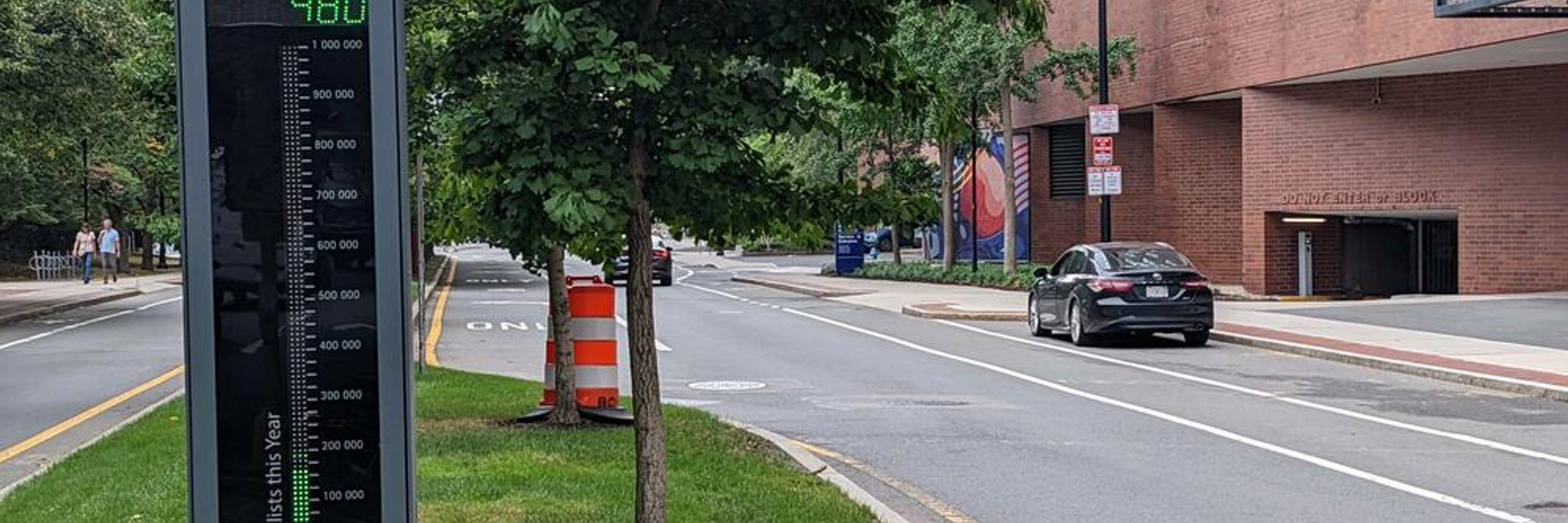
@SnoopJ Just as a comparison, on Tuesday (so not-holiday), the Mass Ave Bridge counted 2694 bikes. So all those pictures of huge crowds biking for the event were less than a normal commuting day in the city.
April 24, 2025 at 11:11 PM
@SnoopJ Just as a comparison, on Tuesday (so not-holiday), the Mass Ave Bridge counted 2694 bikes. So all those pictures of huge crowds biking for the event were less than a normal commuting day in the city.