


Boston Bike Data
@bostonbikedata.better.boston.ap.brid.gy
Exploring biking in Boston through data.
searchable with tootfinder
[bridged from https://better.boston/@BostonBikeData on the fediverse by https://fed.brid.gy/ ]
searchable with tootfinder
[bridged from https://better.boston/@BostonBikeData on the fediverse by https://fed.brid.gy/ ]
Reposted by Boston Bike Data


Reposted by Boston Bike Data

The Year Two quantitative evaluation of the #boston Better Bike Lanes program is out:
https://www.boston.gov/sites/default/files/file/2025/11/Better%20Bike%20Lanes%20Fall%202025%20Eval%20Web%20Version.pdf
Highlights:
* 3000+ additional bike trips DAILY, 55% […]
[Original post on hachyderm.io]
https://www.boston.gov/sites/default/files/file/2025/11/Better%20Bike%20Lanes%20Fall%202025%20Eval%20Web%20Version.pdf
Highlights:
* 3000+ additional bike trips DAILY, 55% […]
[Original post on hachyderm.io]


November 21, 2025 at 10:51 PM
The Year Two quantitative evaluation of the #boston Better Bike Lanes program is out:
https://www.boston.gov/sites/default/files/file/2025/11/Better%20Bike%20Lanes%20Fall%202025%20Eval%20Web%20Version.pdf
Highlights:
* 3000+ additional bike trips DAILY, 55% […]
[Original post on hachyderm.io]
https://www.boston.gov/sites/default/files/file/2025/11/Better%20Bike%20Lanes%20Fall%202025%20Eval%20Web%20Version.pdf
Highlights:
* 3000+ additional bike trips DAILY, 55% […]
[Original post on hachyderm.io]
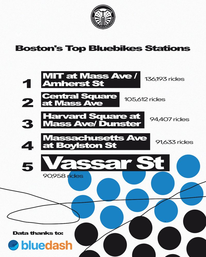
Boston Globe taking a look at BlueBikes usage growth among commuters
https://www.bostonglobe.com/2025/08/04/data/boston-bluebikes-ridership-map/
https://www.bostonglobe.com/2025/08/04/data/boston-bluebikes-ridership-map/

Bluebikes’ popularity has skyrocketed. This map shows where they are used most and where they lag. - The Boston Globe
Driven by a growing network of pickup stations, the introduction of e-bikes, and expanded discount programs, annual trips on Bluebikes have increased by 2.7 million in just four years.
www.bostonglobe.com
August 4, 2025 at 2:29 PM
Boston Globe taking a look at BlueBikes usage growth among commuters
https://www.bostonglobe.com/2025/08/04/data/boston-bluebikes-ridership-map/
https://www.bostonglobe.com/2025/08/04/data/boston-bluebikes-ridership-map/
Reposted by Boston Bike Data

Anyone want to #osm map bike parking in #boston?
Each of these dots is bike parking in OSM and I just don't believe that Boston is really THAT sparse south of the Pike
I'd be happy to teach you how with apps like @everydoor and @streetcomplete
Each of these dots is bike parking in OSM and I just don't believe that Boston is really THAT sparse south of the Pike
I'd be happy to teach you how with apps like @everydoor and @streetcomplete

July 7, 2025 at 2:20 AM
Anyone want to #osm map bike parking in #boston?
Each of these dots is bike parking in OSM and I just don't believe that Boston is really THAT sparse south of the Pike
I'd be happy to teach you how with apps like @everydoor and @streetcomplete
Each of these dots is bike parking in OSM and I just don't believe that Boston is really THAT sparse south of the Pike
I'd be happy to teach you how with apps like @everydoor and @streetcomplete
Reposted by Boston Bike Data
2 new projects from @bikeboston.bsky.social BCU Labs:
A Camberville bike network vision we are calling a Landway (think subway) in collaboration with @cambbikesafety.bsky.social
https://bostoncyclistsunion.org/introducing-the-landway
An interactive map rating every street based on how […]
A Camberville bike network vision we are calling a Landway (think subway) in collaboration with @cambbikesafety.bsky.social
https://bostoncyclistsunion.org/introducing-the-landway
An interactive map rating every street based on how […]
Original post on better.boston
better.boston
May 15, 2025 at 7:39 PM
2 new projects from @bikeboston.bsky.social BCU Labs:
A Camberville bike network vision we are calling a Landway (think subway) in collaboration with @cambbikesafety.bsky.social
https://bostoncyclistsunion.org/introducing-the-landway
An interactive map rating every street based on how […]
A Camberville bike network vision we are calling a Landway (think subway) in collaboration with @cambbikesafety.bsky.social
https://bostoncyclistsunion.org/introducing-the-landway
An interactive map rating every street based on how […]
Reposted by Boston Bike Data

ICYMI two great projects and visualizations from BCU Labs @bikeboston.bsky.social!
1) Landways Map - Camberville's bike network vision - where we are now and what it could be
2) Bike Stress Map - mapping Camberville and Boston streets by biking comfort level
Check out the quoted thread for more!
1) Landways Map - Camberville's bike network vision - where we are now and what it could be
2) Bike Stress Map - mapping Camberville and Boston streets by biking comfort level
Check out the quoted thread for more!
2 new projects from @bikeboston.bsky.social BCU Labs:
A Camberville bike network vision we are calling a Landway (think subway) in collaboration with @cambbikesafety.bsky.social
https://bostoncyclistsunion.org/introducing-the-landway
An interactive map rating every street based on how […]
A Camberville bike network vision we are calling a Landway (think subway) in collaboration with @cambbikesafety.bsky.social
https://bostoncyclistsunion.org/introducing-the-landway
An interactive map rating every street based on how […]
Original post on better.boston
better.boston
May 16, 2025 at 9:08 PM
ICYMI two great projects and visualizations from BCU Labs @bikeboston.bsky.social!
1) Landways Map - Camberville's bike network vision - where we are now and what it could be
2) Bike Stress Map - mapping Camberville and Boston streets by biking comfort level
Check out the quoted thread for more!
1) Landways Map - Camberville's bike network vision - where we are now and what it could be
2) Bike Stress Map - mapping Camberville and Boston streets by biking comfort level
Check out the quoted thread for more!
Reposted by Boston Bike Data
Two new projects from BCU Labs!
🔸 Bike Stress Map - view Boston's streets mapped by comfort level!
🔸 Landways Map - what would Camberville's bike network look like as an MBTA map?
🔸 Bike Stress Map - view Boston's streets mapped by comfort level!
🔸 Landways Map - what would Camberville's bike network look like as an MBTA map?
2 new projects from @bikeboston.bsky.social BCU Labs:
A Camberville bike network vision we are calling a Landway (think subway) in collaboration with @cambbikesafety.bsky.social
https://bostoncyclistsunion.org/introducing-the-landway
An interactive map rating every street based on how […]
A Camberville bike network vision we are calling a Landway (think subway) in collaboration with @cambbikesafety.bsky.social
https://bostoncyclistsunion.org/introducing-the-landway
An interactive map rating every street based on how […]
Original post on better.boston
better.boston
May 15, 2025 at 8:02 PM
Two new projects from BCU Labs!
🔸 Bike Stress Map - view Boston's streets mapped by comfort level!
🔸 Landways Map - what would Camberville's bike network look like as an MBTA map?
🔸 Bike Stress Map - view Boston's streets mapped by comfort level!
🔸 Landways Map - what would Camberville's bike network look like as an MBTA map?
2 new projects from @bikeboston.bsky.social BCU Labs:
A Camberville bike network vision we are calling a Landway (think subway) in collaboration with @cambbikesafety.bsky.social
https://bostoncyclistsunion.org/introducing-the-landway
An interactive map rating every street based on how […]
A Camberville bike network vision we are calling a Landway (think subway) in collaboration with @cambbikesafety.bsky.social
https://bostoncyclistsunion.org/introducing-the-landway
An interactive map rating every street based on how […]
Original post on better.boston
better.boston
May 15, 2025 at 7:39 PM
2 new projects from @bikeboston.bsky.social BCU Labs:
A Camberville bike network vision we are calling a Landway (think subway) in collaboration with @cambbikesafety.bsky.social
https://bostoncyclistsunion.org/introducing-the-landway
An interactive map rating every street based on how […]
A Camberville bike network vision we are calling a Landway (think subway) in collaboration with @cambbikesafety.bsky.social
https://bostoncyclistsunion.org/introducing-the-landway
An interactive map rating every street based on how […]
Reposted by Boston Bike Data
Reposted by Boston Bike Data
Do you like bikes? Do you want to make friends with people that like bikes? Do you want to confuse people when you tell them you have only ever gotten to Montreal by bike? ...I have just the adventure for you!
I've done Bostreal the past 2 years, it's a […]
[Original post on urbanists.social]
I've done Bostreal the past 2 years, it's a […]
[Original post on urbanists.social]


January 9, 2025 at 1:04 AM
Do you like bikes? Do you want to make friends with people that like bikes? Do you want to confuse people when you tell them you have only ever gotten to Montreal by bike? ...I have just the adventure for you!
I've done Bostreal the past 2 years, it's a […]
[Original post on urbanists.social]
I've done Bostreal the past 2 years, it's a […]
[Original post on urbanists.social]
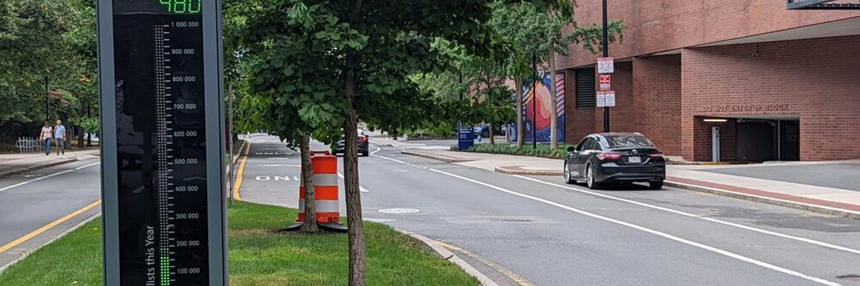
Some great stats about recent bike improvement projects from Boston's State of the Streets tonight!
#bikeboston BikeTooter
#bikeboston BikeTooter

November 20, 2024 at 1:26 AM
Some great stats about recent bike improvement projects from Boston's State of the Streets tonight!
#bikeboston BikeTooter
#bikeboston BikeTooter