


Boston Bike Data
@bostonbikedata.better.boston.ap.brid.gy
Exploring biking in Boston through data.
searchable with tootfinder
[bridged from https://better.boston/@BostonBikeData on the fediverse by https://fed.brid.gy/ ]
searchable with tootfinder
[bridged from https://better.boston/@BostonBikeData on the fediverse by https://fed.brid.gy/ ]
This is a concept called Level of Traffic Stress and it is important because two streets with a bike lane are not the same experience to ride on.
For example, Hampshire St it is common to see young children riding in the separated bike lanes, while only the […]
[Original post on better.boston]
For example, Hampshire St it is common to see young children riding in the separated bike lanes, while only the […]
[Original post on better.boston]


May 15, 2025 at 7:55 PM
This is a concept called Level of Traffic Stress and it is important because two streets with a bike lane are not the same experience to ride on.
For example, Hampshire St it is common to see young children riding in the separated bike lanes, while only the […]
[Original post on better.boston]
For example, Hampshire St it is common to see young children riding in the separated bike lanes, while only the […]
[Original post on better.boston]
The other project is much more granular. Every street in Boston, Cambridge, Somerville, and Brookline is rated based on how stressful it is to ride due to automotive traffic
https://labs.bostoncyclistsunion.org/#/map
https://labs.bostoncyclistsunion.org/#/map

May 15, 2025 at 7:53 PM
The other project is much more granular. Every street in Boston, Cambridge, Somerville, and Brookline is rated based on how stressful it is to ride due to automotive traffic
https://labs.bostoncyclistsunion.org/#/map
https://labs.bostoncyclistsunion.org/#/map
But the vision is not some wild idea, many of the major gaps in this network have plans to be improved in the near future. We are starting to track these projects in a single place https://landway.bostoncyclistsunion.org/

May 15, 2025 at 7:49 PM
But the vision is not some wild idea, many of the major gaps in this network have plans to be improved in the near future. We are starting to track these projects in a single place https://landway.bostoncyclistsunion.org/
This map is a vision, so we also want to show what the network currently looks like and how such a disconnected network is holding people back from feeling safe enough to bike here

May 15, 2025 at 7:45 PM
This map is a vision, so we also want to show what the network currently looks like and how such a disconnected network is holding people back from feeling safe enough to bike here
The Camberville Landway map is inspired by the design of subway maps, showing common major routes to travel across town via bike (or other personal mobility device). This is the vision of a network that, when built, will make Camberville as good to bike in as Paris and Amsterdam.

May 15, 2025 at 7:43 PM
The Camberville Landway map is inspired by the design of subway maps, showing common major routes to travel across town via bike (or other personal mobility device). This is the vision of a network that, when built, will make Camberville as good to bike in as Paris and Amsterdam.
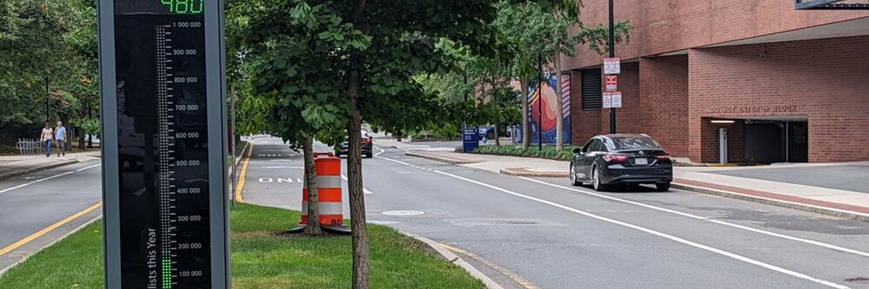
Some great stats about recent bike improvement projects from Boston's State of the Streets tonight!
#bikeboston BikeTooter
#bikeboston BikeTooter

November 20, 2024 at 1:26 AM
Some great stats about recent bike improvement projects from Boston's State of the Streets tonight!
#bikeboston BikeTooter
#bikeboston BikeTooter