


Transit Maps
@transitmap.net
A celebration of transit maps and diagrams from around the world. Visit the blog at transitmap.net. 🔁 Reposts appreciated!
Transit map prints sold at: transitmap.net/store
Transit mappers starter pack: https://go.bsky.app/32jXV41
Transit map prints sold at: transitmap.net/store
Transit mappers starter pack: https://go.bsky.app/32jXV41
Reposted by Transit Maps

Where are my transit people - anyone know more about this old subway/train map on the floor of Grand Central?
It looks so cool but the full thing didn’t appear to withstand updates to flooring over the years. I saw it out of the corner of my eye in a tucked away corner near the food concourse.
It looks so cool but the full thing didn’t appear to withstand updates to flooring over the years. I saw it out of the corner of my eye in a tucked away corner near the food concourse.

February 6, 2026 at 4:33 PM
Where are my transit people - anyone know more about this old subway/train map on the floor of Grand Central?
It looks so cool but the full thing didn’t appear to withstand updates to flooring over the years. I saw it out of the corner of my eye in a tucked away corner near the food concourse.
It looks so cool but the full thing didn’t appear to withstand updates to flooring over the years. I saw it out of the corner of my eye in a tucked away corner near the food concourse.
Reposted by Transit Maps

It took two years (with other projects in between) but I've finished 44,703 stitches of DMC 162 — Very Light Blue that make up all the waterways on my 20-inch wide cross stitch map of the NYC subway system.
If I never touch another skein of 162 again it'll be too soon
If I never touch another skein of 162 again it'll be too soon

January 13, 2026 at 2:14 AM
It took two years (with other projects in between) but I've finished 44,703 stitches of DMC 162 — Very Light Blue that make up all the waterways on my 20-inch wide cross stitch map of the NYC subway system.
If I never touch another skein of 162 again it'll be too soon
If I never touch another skein of 162 again it'll be too soon
Yep, that's better already. One thought: there's perhaps an argument to be made that something this diagrammatic doesn't need the dog-leg in the Ellenbrook line, which seems very fussy in comparison to the straight trajectories of all the other lines.

We may have made an executive decision with this one. We’ll see how it turns out, I guess.
January 14, 2026 at 4:42 PM
Yep, that's better already. One thought: there's perhaps an argument to be made that something this diagrammatic doesn't need the dog-leg in the Ellenbrook line, which seems very fussy in comparison to the straight trajectories of all the other lines.
Reposted by Transit Maps
New on the blog! The official diagram of Transperth rail services has a lot of problems, but here's the two big ones:

Submission – Official Map: Transperth Rail Diagram, 2026
Submitted by Noah, who says: I would appreciate a review of the updated system map for Transperth. Transit Maps says: This dates from October 2025, when the Armadale line was extended one station to Byford. Again, this is one of those diagrams that gets the job done, but absolutely lacks any finesse and craft. There's a whole litany of problems here — angled labels when there's plenty of room for them to be horizontal, inconsistent corner radii, a river that just ends (where's the West Australian coast?), icons that are visually too similar to each other, etc.
transitmap.net
January 12, 2026 at 4:02 PM
New on the blog! The official diagram of Transperth rail services has a lot of problems, but here's the two big ones:
I agree with Mike 100% here – this type of stuff should not be allowed.
Unforgivable. Mixing basic passenger information with advertising to the confusion of the former. Brand prostitution.
flic.kr/p/2rRd5mF
flic.kr/p/2rRd5mF

IMG_5292
flic.kr
January 12, 2026 at 4:52 PM
I agree with Mike 100% here – this type of stuff should not be allowed.
Reposted by Transit Maps

Welcome to all! If you’re looking for people to follow, here are some great voices on transit, active transport, cities…
🧵
go.bsky.app/U4hN8P9
🧵
go.bsky.app/U4hN8P9
January 10, 2026 at 8:30 PM
Welcome to all! If you’re looking for people to follow, here are some great voices on transit, active transport, cities…
🧵
go.bsky.app/U4hN8P9
🧵
go.bsky.app/U4hN8P9
New on the blog! The official diagram of Transperth rail services has a lot of problems, but here's the two big ones:
Submission – Official Map: Transperth Rail Diagram, 2026
Submitted by Noah, who says: I would appreciate a review of the updated system map for Transperth. Transit Maps says: This dates from October 2025, when the Armadale line was extended one station to Byford. Again, this is one of those diagrams that gets the job done, but absolutely lacks any finesse and craft. There's a whole litany of problems here — angled labels when there's plenty of room for them to be horizontal, inconsistent corner radii, a river that just ends (where's the West Australian coast?), icons that are visually too similar to each other, etc.
transitmap.net
January 12, 2026 at 4:02 PM
New on the blog! The official diagram of Transperth rail services has a lot of problems, but here's the two big ones:
I'm aware that the blog is down at the moment... looking into it!
December 30, 2025 at 7:28 PM
I'm aware that the blog is down at the moment... looking into it!
Reposted by Transit Maps

🇨🇳🗽 i finally got around to remaking the terrible subway map of my hometown beijing, this time in the style of vignelli!
full image: ibb.co/album/tzt8H6
full image: ibb.co/album/tzt8H6

December 11, 2025 at 1:01 AM
🇨🇳🗽 i finally got around to remaking the terrible subway map of my hometown beijing, this time in the style of vignelli!
full image: ibb.co/album/tzt8H6
full image: ibb.co/album/tzt8H6
Reposted by Transit Maps

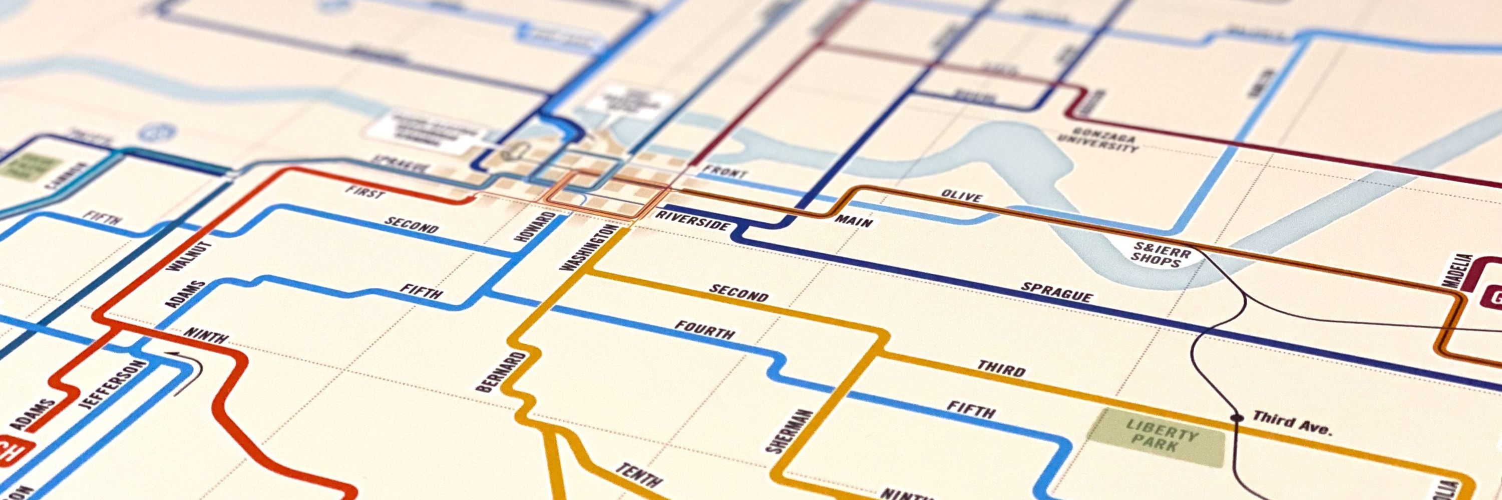
If you enjoy both #RhodeIsland and #rivers, stop by The Map Center (@mapcenter.com) to check out (and maybe buy?) this poster I designed for them, showing the state's streams in the style of a transit network map.


December 10, 2025 at 8:18 PM
If you enjoy both #RhodeIsland and #rivers, stop by The Map Center (@mapcenter.com) to check out (and maybe buy?) this poster I designed for them, showing the state's streams in the style of a transit network map.
Reposted by Transit Maps
I don't get to print this diagram of the European E-road network very often, but I can still look at it with pride when I do. I can't say that about every piece of design I did five years ago!
More info on the project here: transitmap.net/e-road-netwo...
More info on the project here: transitmap.net/e-road-netwo...


December 13, 2025 at 4:32 AM
I don't get to print this diagram of the European E-road network very often, but I can still look at it with pride when I do. I can't say that about every piece of design I did five years ago!
More info on the project here: transitmap.net/e-road-netwo...
More info on the project here: transitmap.net/e-road-netwo...
December 13, 2025 at 4:32 AM
I don't get to print this diagram of the European E-road network very often, but I can still look at it with pride when I do. I can't say that about every piece of design I did five years ago!
More info on the project here: transitmap.net/e-road-netwo...
More info on the project here: transitmap.net/e-road-netwo...
Reposted by Transit Maps

Bad new out of Yakima, where the city council has declined to renew their operating agreement with Yakima Valley Trolleys, meaning that trolley rides and museum events will be suspended at the end of the year.
Visit www.savethetrolleys.com to take action – sign a petition or volunteer!
Visit www.savethetrolleys.com to take action – sign a petition or volunteer!
December 11, 2025 at 5:26 AM
Bad new out of Yakima, where the city council has declined to renew their operating agreement with Yakima Valley Trolleys, meaning that trolley rides and museum events will be suspended at the end of the year.
Visit www.savethetrolleys.com to take action – sign a petition or volunteer!
Visit www.savethetrolleys.com to take action – sign a petition or volunteer!
Reposted by Transit Maps
New on the blog! A long-overdue look at the new Chicago 'L' diagram.

Submission – Official Map: Chicago ‘L’, 2025
Submitted by Scott (among others), who says: CTA updated their iconic 'L' diagram earlier this year, and now that the temporary station outages for the Red-Purple Modernization project have been completed, figured this would be a great time to get your thoughts since the new version is a pretty dramatic departure from the previous iterations. Transit Maps says: Well, this one has sat in my queue for way too long – sorry for the delay in getting to this interesting new development in the world of Chicago rail maps!
transitmap.net
December 10, 2025 at 5:16 PM
New on the blog! A long-overdue look at the new Chicago 'L' diagram.
New on the blog! A long-overdue look at the new Chicago 'L' diagram.
Submission – Official Map: Chicago ‘L’, 2025
Submitted by Scott (among others), who says: CTA updated their iconic 'L' diagram earlier this year, and now that the temporary station outages for the Red-Purple Modernization project have been completed, figured this would be a great time to get your thoughts since the new version is a pretty dramatic departure from the previous iterations. Transit Maps says: Well, this one has sat in my queue for way too long – sorry for the delay in getting to this interesting new development in the world of Chicago rail maps!
transitmap.net
December 10, 2025 at 5:16 PM
New on the blog! A long-overdue look at the new Chicago 'L' diagram.
Reposted by Transit Maps
New on the blog! A lovely little fantasy map for Honolulu's Skyline by Justin Kunimune.

Submission – Fantasy Map: Honolulu Skyline by Justin Kunimune
Submitted by Justin, who says: Hi, I'm a big fan of this blog! I've been working on a fantasy diagram for the Honolulu rapid transit system, Skyline, and wanted to submit it for you to review. As of this year, the system has one line that runs from East Kapolei (Kualakaʻi Station) to Kalihi (Kahauiki Station), with plans to extend it into downtown Honolulu.
transitmap.net
December 8, 2025 at 4:00 PM
New on the blog! A lovely little fantasy map for Honolulu's Skyline by Justin Kunimune.
New on the blog! A lovely little fantasy map for Honolulu's Skyline by Justin Kunimune.
Submission – Fantasy Map: Honolulu Skyline by Justin Kunimune
Submitted by Justin, who says: Hi, I'm a big fan of this blog! I've been working on a fantasy diagram for the Honolulu rapid transit system, Skyline, and wanted to submit it for you to review. As of this year, the system has one line that runs from East Kapolei (Kualakaʻi Station) to Kalihi (Kahauiki Station), with plans to extend it into downtown Honolulu.
transitmap.net
December 8, 2025 at 4:00 PM
New on the blog! A lovely little fantasy map for Honolulu's Skyline by Justin Kunimune.
Only a few hours left to grab a great deal on a great transit map print!
It's Cyber Monday – the last day to get 15% off all prints in the Transit Maps store before Christmas (no more sales this year)!
My original maps: transitmap.net/store/produc...
Vintage reproductions: transitmap.net/store/produc...
My original maps: transitmap.net/store/produc...
Vintage reproductions: transitmap.net/store/produc...


December 2, 2025 at 12:46 AM
Only a few hours left to grab a great deal on a great transit map print!
It's Cyber Monday – the last day to get 15% off all prints in the Transit Maps store before Christmas (no more sales this year)!
My original maps: transitmap.net/store/produc...
Vintage reproductions: transitmap.net/store/produc...
My original maps: transitmap.net/store/produc...
Vintage reproductions: transitmap.net/store/produc...
December 1, 2025 at 4:21 PM
It's Cyber Monday – the last day to get 15% off all prints in the Transit Maps store before Christmas (no more sales this year)!
My original maps: transitmap.net/store/produc...
Vintage reproductions: transitmap.net/store/produc...
My original maps: transitmap.net/store/produc...
Vintage reproductions: transitmap.net/store/produc...
It's Small Business Saturday, and Transit Maps is the very definition of "small," with just one employee (me!). Support independent creators this holiday season.
Time for a print sale! Get your Christmas shopping done early with one of the great maps in the Transit Maps store – 15% off everything through Monday, December 1!
transitmap.net/store/prints...
transitmap.net/store/prints...

November 29, 2025 at 5:37 PM
It's Small Business Saturday, and Transit Maps is the very definition of "small," with just one employee (me!). Support independent creators this holiday season.
Time for a print sale! Get your Christmas shopping done early with one of the great maps in the Transit Maps store – 15% off everything through Monday, December 1!
transitmap.net/store/prints...
transitmap.net/store/prints...
November 28, 2025 at 6:55 PM
Time for a print sale! Get your Christmas shopping done early with one of the great maps in the Transit Maps store – 15% off everything through Monday, December 1!
transitmap.net/store/prints...
transitmap.net/store/prints...
Well, that's a new change to my Amtrak as Subway Map that I didn't have on my bingo card...

Amtrak's San Joaquins service in California has been renamed as Gold Runner
media.amtrak.com/2025/11/amtr...
media.amtrak.com/2025/11/amtr...

Amtrak San Joaquins Becomes Gold Runner, Marking a New Era for California Passenger Rail - Amtrak Media
Stockton, Calif. – The San Joaquin Joint Powers Authority (SJJPA) is proud to introduce a new chapter in the history of California’s intercity passenger
media.amtrak.com
November 4, 2025 at 10:33 PM
Well, that's a new change to my Amtrak as Subway Map that I didn't have on my bingo card...
Leaving aside whether or not you actually need to show branches/alternate termini like this (I would say you don't), this is a pretty ugly way to apply hatching to the Silver Line. The DC Metro map has done this much better before.

November 4, 2025 at 4:12 AM
Leaving aside whether or not you actually need to show branches/alternate termini like this (I would say you don't), this is a pretty ugly way to apply hatching to the Silver Line. The DC Metro map has done this much better before.
This superb isochrone of travel time by rail in 1882 France has always been one of the most popular prints on the site – and with good reason!
transitmap.net/store/produc...
transitmap.net/store/produc...

November 4, 2025 at 3:29 AM
This superb isochrone of travel time by rail in 1882 France has always been one of the most popular prints on the site – and with good reason!
transitmap.net/store/produc...
transitmap.net/store/produc...
I'm printing up some maps tonight – add yours to my queue by placing an order now! I'll get out in the mail tomorrow.
transitmap.net/store/prints...
transitmap.net/store/prints...

November 4, 2025 at 2:59 AM
I'm printing up some maps tonight – add yours to my queue by placing an order now! I'll get out in the mail tomorrow.
transitmap.net/store/prints...
transitmap.net/store/prints...