


Scott Kehler 🇨🇦
@scottdkehler.bsky.social
President and Chief Scientist of Weatherlogics Inc
Reposted by Scott Kehler 🇨🇦

We’re expanding our team and looking for two talented Meteorologists. If you’re passionate about atmospheric science, we want to meet you!
Learn more: www.weatherlogics.com/careers/
Learn more: www.weatherlogics.com/careers/

February 11, 2026 at 9:03 PM
We’re expanding our team and looking for two talented Meteorologists. If you’re passionate about atmospheric science, we want to meet you!
Learn more: www.weatherlogics.com/careers/
Learn more: www.weatherlogics.com/careers/
Congratulations, you've made it through the worst of winter in southern Manitoba. The first half of February will be much warmer! This week starts chilly, but by Thursday we should be around the freezing mark.
February 2, 2026 at 4:48 PM
Congratulations, you've made it through the worst of winter in southern Manitoba. The first half of February will be much warmer! This week starts chilly, but by Thursday we should be around the freezing mark.
The wind chill hit -51 in Winnipeg this morning, which is a record low for Jan 25. That was due to a combined air temp of -38 C and 15 km/h winds. Readings of -50 and lower are uncommon. The coldest ever wind chill in Winnipeg was -57.
January 25, 2026 at 3:36 PM
The wind chill hit -51 in Winnipeg this morning, which is a record low for Jan 25. That was due to a combined air temp of -38 C and 15 km/h winds. Readings of -50 and lower are uncommon. The coldest ever wind chill in Winnipeg was -57.
The low in Winnipeg this morning was -38.2 C. The -40 C mark contains to elude the city, with the last such reading now almost 20 years ago, on February 5, 2007. The provincial cold spot was Wasagaming, with a low of -43.0 C!
January 25, 2026 at 3:26 PM
The low in Winnipeg this morning was -38.2 C. The -40 C mark contains to elude the city, with the last such reading now almost 20 years ago, on February 5, 2007. The provincial cold spot was Wasagaming, with a low of -43.0 C!
Extreme cold this morning in Manitoba. Here are some of the locations that dropped below -40 C:
Wasagaming: -42.3 C
Flin Flon: -42.1 C
Shoal Lake: -41.8 C
Roblin: -41.2 C
The Pas: -40.9 C
Grand Rapids: -40.9 C
Extreme cold will recur again tonight.
Wasagaming: -42.3 C
Flin Flon: -42.1 C
Shoal Lake: -41.8 C
Roblin: -41.2 C
The Pas: -40.9 C
Grand Rapids: -40.9 C
Extreme cold will recur again tonight.
January 24, 2026 at 5:04 PM
Extreme cold this morning in Manitoba. Here are some of the locations that dropped below -40 C:
Wasagaming: -42.3 C
Flin Flon: -42.1 C
Shoal Lake: -41.8 C
Roblin: -41.2 C
The Pas: -40.9 C
Grand Rapids: -40.9 C
Extreme cold will recur again tonight.
Wasagaming: -42.3 C
Flin Flon: -42.1 C
Shoal Lake: -41.8 C
Roblin: -41.2 C
The Pas: -40.9 C
Grand Rapids: -40.9 C
Extreme cold will recur again tonight.
A brief reprieve from adverse winter weather is expected today in southern Manitoba before another "MacKenzie Screamer" arrives tomorrow. Additional light snow is expected and strong winds will again produce significant blowing snow. Poor travel conditions should be expected.

January 17, 2026 at 5:15 PM
A brief reprieve from adverse winter weather is expected today in southern Manitoba before another "MacKenzie Screamer" arrives tomorrow. Additional light snow is expected and strong winds will again produce significant blowing snow. Poor travel conditions should be expected.
Reposted by Scott Kehler 🇨🇦
We’re hiring for Summer 2026! 🌩️
Weatherlogics is looking for our next Meteorological Assistant. If you are passionate about severe weather and data analysis, we want to hear from you.
Apply here: www.weatherlogics.com/careers/
Weatherlogics is looking for our next Meteorological Assistant. If you are passionate about severe weather and data analysis, we want to hear from you.
Apply here: www.weatherlogics.com/careers/

January 15, 2026 at 3:49 PM
We’re hiring for Summer 2026! 🌩️
Weatherlogics is looking for our next Meteorological Assistant. If you are passionate about severe weather and data analysis, we want to hear from you.
Apply here: www.weatherlogics.com/careers/
Weatherlogics is looking for our next Meteorological Assistant. If you are passionate about severe weather and data analysis, we want to hear from you.
Apply here: www.weatherlogics.com/careers/
Visibility in the Red River Valley is now near zero at times due to heavy snow and blowing snow. Winds will continue to increase this afternoon. #mbstorm
December 19, 2025 at 7:37 PM
Visibility in the Red River Valley is now near zero at times due to heavy snow and blowing snow. Winds will continue to increase this afternoon. #mbstorm
Snow is getting underway in the Red River Valley from the next Clipper. Winds will also increase this afternoon, creating poor travel conditions. Many highways in western Manitoba are already closed. Use caution if heading out - conditions will worsen quickly.
December 19, 2025 at 5:47 PM
Snow is getting underway in the Red River Valley from the next Clipper. Winds will also increase this afternoon, creating poor travel conditions. Many highways in western Manitoba are already closed. Use caution if heading out - conditions will worsen quickly.
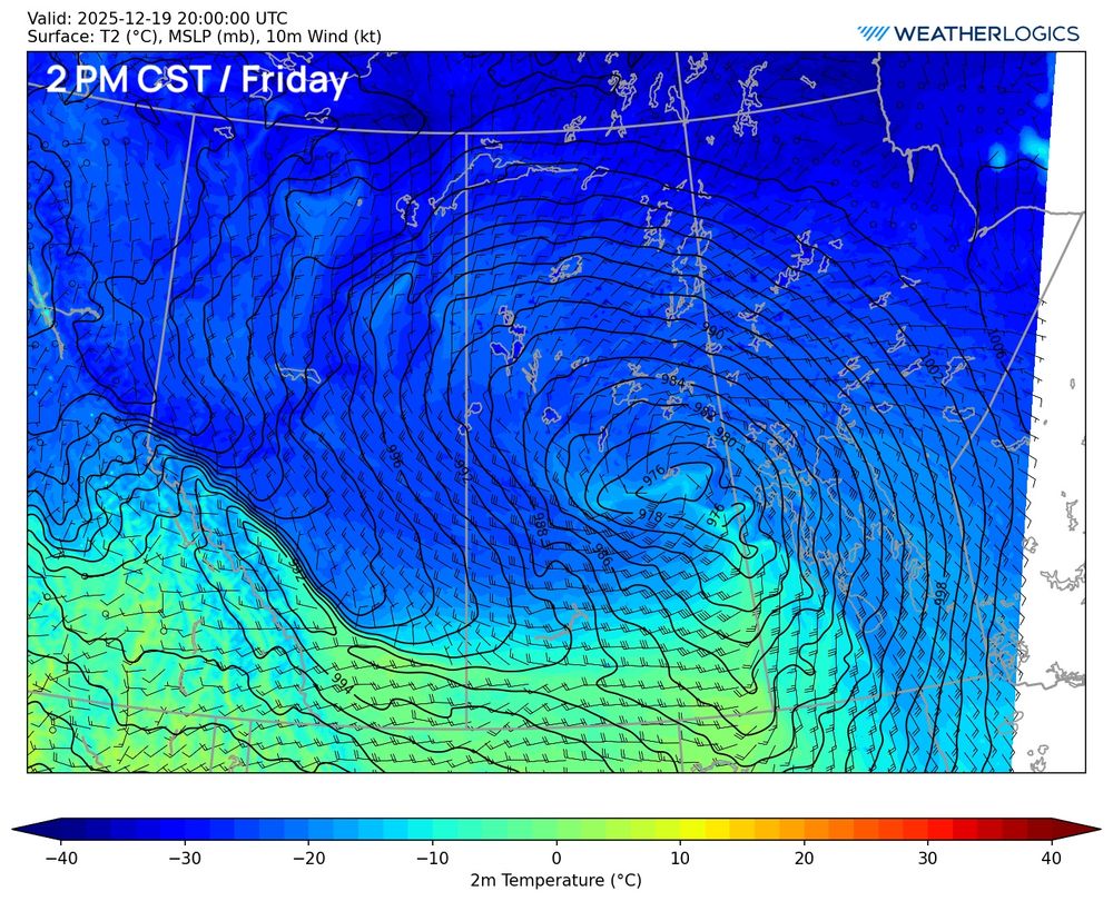
On tomorrow's noon surface forecast map you can see the next Clipper approaching from Saskatchewan. Meanwhile today's Clipper is still trucking along through central Quebec. (data from the @weatherlogics.bsky.social WRF).

December 18, 2025 at 9:25 PM
On tomorrow's noon surface forecast map you can see the next Clipper approaching from Saskatchewan. Meanwhile today's Clipper is still trucking along through central Quebec. (data from the @weatherlogics.bsky.social WRF).
Today's @weatherlogics.bsky.social 4-km WRF simulation over western Canada suggests that blizzard conditions are likely to redevelop tomorrow in southern Manitoba. Snow will move from west to east during the day, along with southerly winds of 40-60 km/h gusting to 60-80 km/h.

December 18, 2025 at 8:50 PM
Today's @weatherlogics.bsky.social 4-km WRF simulation over western Canada suggests that blizzard conditions are likely to redevelop tomorrow in southern Manitoba. Snow will move from west to east during the day, along with southerly winds of 40-60 km/h gusting to 60-80 km/h.
While tomorrow's Alberta Clipper technically isn't as strong as today's, it may still pack a punch. Strong southerly winds are expected in the Red River Valley in the afternoon, along with more snow, so near blizzard conditions are possible again!
December 18, 2025 at 4:29 PM
While tomorrow's Alberta Clipper technically isn't as strong as today's, it may still pack a punch. Strong southerly winds are expected in the Red River Valley in the afternoon, along with more snow, so near blizzard conditions are possible again!
The worst of the Alberta Clipper is now over, but conditions will remain poor today as blowing snow continues. Winds will gradually ease, calming right down tonight as high pressure builds in. High pressure won't last long - the next Clipper arrives tomorrow!
December 18, 2025 at 4:14 PM
The worst of the Alberta Clipper is now over, but conditions will remain poor today as blowing snow continues. Winds will gradually ease, calming right down tonight as high pressure builds in. High pressure won't last long - the next Clipper arrives tomorrow!
This storm officially met blizzard criteria in Winnipeg as visibility at the airport remained below 400 m (0.25 miles) for at least 4 consecutive hours (criteria met for 6 hours total).
Note: The definition of a blizzard is now different from that of a blizzard warning.
Note: The definition of a blizzard is now different from that of a blizzard warning.
December 18, 2025 at 4:06 PM
This storm officially met blizzard criteria in Winnipeg as visibility at the airport remained below 400 m (0.25 miles) for at least 4 consecutive hours (criteria met for 6 hours total).
Note: The definition of a blizzard is now different from that of a blizzard warning.
Note: The definition of a blizzard is now different from that of a blizzard warning.
Weatherlogics users report freezing rain with this initial band of precipitation that is moving across southern Manitoba. Watch for slippery conditions today before the heavy snow and wind begins tonight!

December 17, 2025 at 5:59 PM
Weatherlogics users report freezing rain with this initial band of precipitation that is moving across southern Manitoba. Watch for slippery conditions today before the heavy snow and wind begins tonight!
A significant Alberta Clipper is still on track to impact the Prairies starting tomorrow. For southern Manitoba, the worst will be Wednesday night-Thursday morning. Travel conditions will be very dangerous and highway closures are likely. Here is our latest snowfall forecast.

December 16, 2025 at 4:54 PM
A significant Alberta Clipper is still on track to impact the Prairies starting tomorrow. For southern Manitoba, the worst will be Wednesday night-Thursday morning. Travel conditions will be very dangerous and highway closures are likely. Here is our latest snowfall forecast.
Winnipeg has set a new daily high temperature record today. The high up to 10:39 am was 5.9 C, beating the previous record of 5.6 C set in 1877.
Even warmer temperatures are being reported elsewhere, with values of 7-8 C in Morden/Portage/McCreary.
Even warmer temperatures are being reported elsewhere, with values of 7-8 C in Morden/Portage/McCreary.
December 16, 2025 at 4:41 PM
Winnipeg has set a new daily high temperature record today. The high up to 10:39 am was 5.9 C, beating the previous record of 5.6 C set in 1877.
Even warmer temperatures are being reported elsewhere, with values of 7-8 C in Morden/Portage/McCreary.
Even warmer temperatures are being reported elsewhere, with values of 7-8 C in Morden/Portage/McCreary.
A wild week of weather is on tap for southern Manitoba, starting tonight:
- An Alberta clipper will bring a chance of freezing rain tonight and early Tuesday.
- Tuesday will see near-record highs as a mild Pacific air mass sweeps in.
continued...
- An Alberta clipper will bring a chance of freezing rain tonight and early Tuesday.
- Tuesday will see near-record highs as a mild Pacific air mass sweeps in.
continued...

December 15, 2025 at 4:56 PM
A wild week of weather is on tap for southern Manitoba, starting tonight:
- An Alberta clipper will bring a chance of freezing rain tonight and early Tuesday.
- Tuesday will see near-record highs as a mild Pacific air mass sweeps in.
continued...
- An Alberta clipper will bring a chance of freezing rain tonight and early Tuesday.
- Tuesday will see near-record highs as a mild Pacific air mass sweeps in.
continued...
Some cold temperatures in the Yukon today - even by arctic standards! These are air temperatures only, not the wind chill:

December 10, 2025 at 8:34 PM
Some cold temperatures in the Yukon today - even by arctic standards! These are air temperatures only, not the wind chill:

Canada now has a colour-coded alerting system. My early thoughts: 1) Emphasizing colours (yellow-orange-red) is good because severity is more obvious than calling things watches-warnings-advisories. 2) The main issue I see is how these are going to be issued.


November 26, 2025 at 7:08 PM
Canada now has a colour-coded alerting system. My early thoughts: 1) Emphasizing colours (yellow-orange-red) is good because severity is more obvious than calling things watches-warnings-advisories. 2) The main issue I see is how these are going to be issued.
Canada now has its own AI weather model (developed by ECCC; it is meant to be equivalent to GDPS). Here is the snow forecast produced by model for this week's system (Monday-Tuesday):


November 24, 2025 at 3:27 AM
Canada now has its own AI weather model (developed by ECCC; it is meant to be equivalent to GDPS). Here is the snow forecast produced by model for this week's system (Monday-Tuesday):
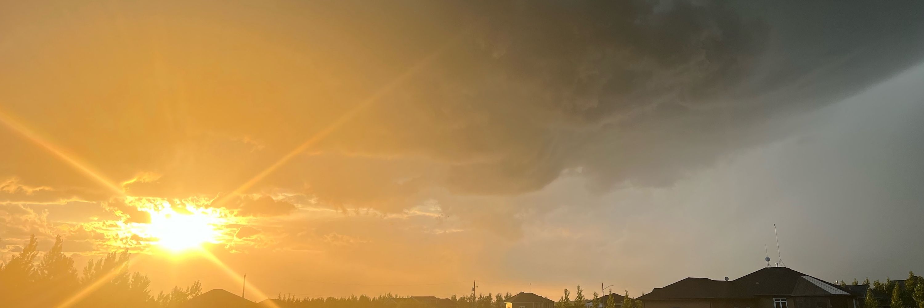
Last night’s northern lights over Winnipeg!

November 6, 2025 at 3:18 PM
Last night’s northern lights over Winnipeg!
The growing season finally came to an end last night in urban Winnipeg. The Forks recorded a low temperature of -1.1 C, the first frost since April 30. This capped a remarkable 175 day-long growing season.
October 23, 2025 at 2:42 PM
The growing season finally came to an end last night in urban Winnipeg. The Forks recorded a low temperature of -1.1 C, the first frost since April 30. This capped a remarkable 175 day-long growing season.
Are you interested in AI and Meteorology?
I am helping to organize this CMOS workshop which will share the exciting AI-related work being done in Canada within the field of meteorology. More details at the link below:
I am helping to organize this CMOS workshop which will share the exciting AI-related work being done in Canada within the field of meteorology. More details at the link below:

AI and Meteorology Workshop - Atelier de l'IA et de la météorologie
Details: https://www.cmos.ca/site/congress/AIMeteorologyWorkshop?nav=sidebar
Details: https://www.cmos.ca/site/congress/AIMeteorologyWorkshop?nav=sidebar
October 16, 2025 at 3:09 PM
Are you interested in AI and Meteorology?
I am helping to organize this CMOS workshop which will share the exciting AI-related work being done in Canada within the field of meteorology. More details at the link below:
I am helping to organize this CMOS workshop which will share the exciting AI-related work being done in Canada within the field of meteorology. More details at the link below: