


Scott Kehler 🇨🇦
@scottdkehler.bsky.social
President and Chief Scientist of Weatherlogics Inc
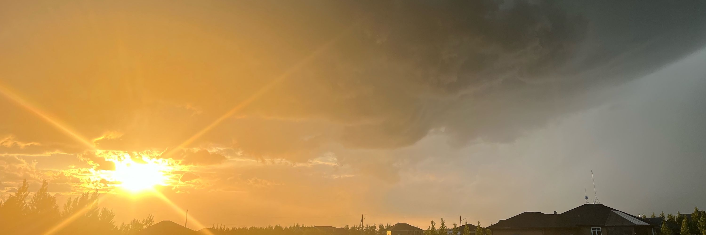
Last night’s northern lights over Winnipeg!

November 6, 2025 at 3:18 PM
Last night’s northern lights over Winnipeg!
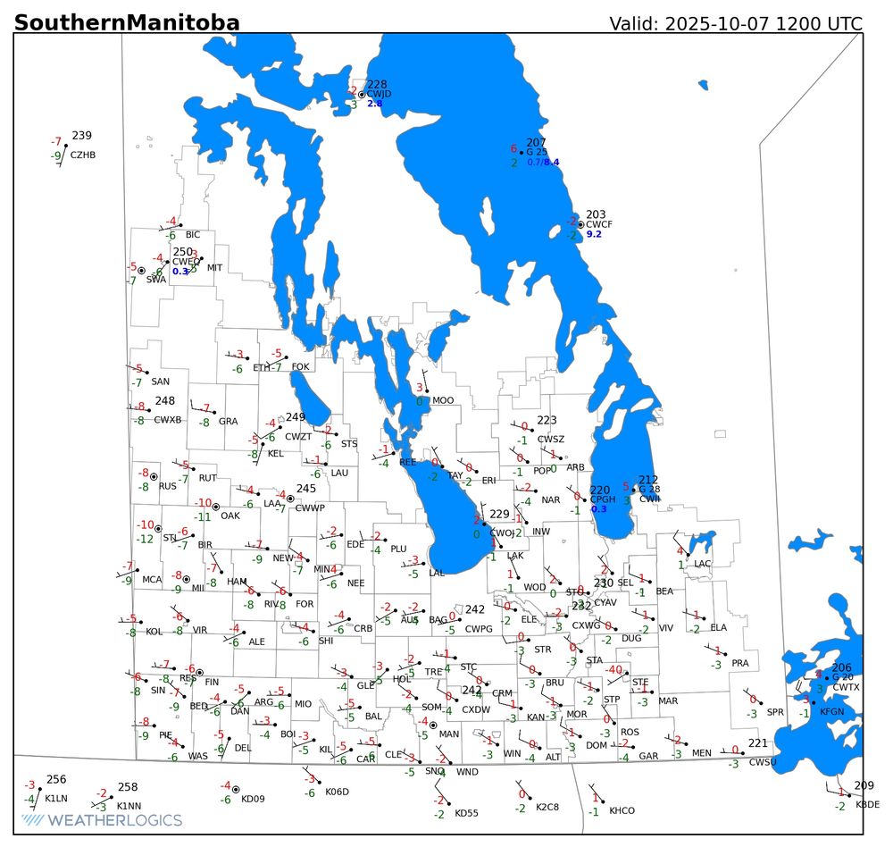
Frost occurred over most of southern Manitoba this morning, with a hard freeze in Western Manitoba. Some locations in Westman got as low as -10 C! #mbwx
October 7, 2025 at 2:50 PM
Frost occurred over most of southern Manitoba this morning, with a hard freeze in Western Manitoba. Some locations in Westman got as low as -10 C! #mbwx
There was a hard freeze in southern Saskatchewan this morning. Mankota, SK got all the way down to -10 C! Frost also occurred in Western Manitoba, with the lowest temperatures near the Saskatchewan border. Frost is likely again tonight in Westman - it will be patchy farther east.

October 6, 2025 at 4:22 PM
There was a hard freeze in southern Saskatchewan this morning. Mankota, SK got all the way down to -10 C! Frost also occurred in Western Manitoba, with the lowest temperatures near the Saskatchewan border. Frost is likely again tonight in Westman - it will be patchy farther east.
I spotted some unusual mammatus clouds overhead this afternoon. They’re unusual because normally mammatus are associated with strong thunderstorms. In this case there are just some rain showers in the area. #mbwx

October 4, 2025 at 8:36 PM
I spotted some unusual mammatus clouds overhead this afternoon. They’re unusual because normally mammatus are associated with strong thunderstorms. In this case there are just some rain showers in the area. #mbwx
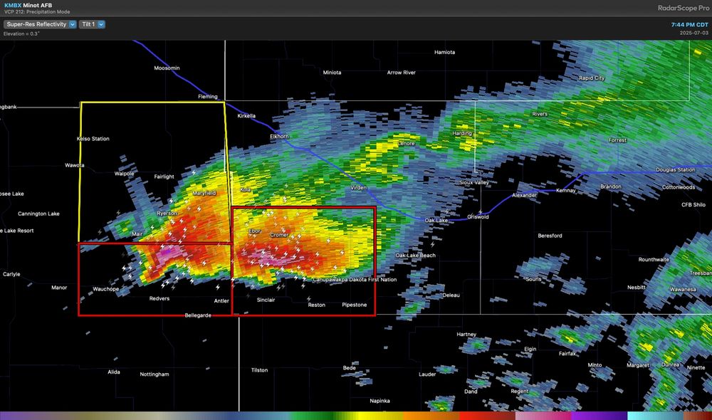
Watching an area of thunderstorms that are developing over southeastern MB. These storms are being triggered semi-parallel to a stationary front over northern Minnesota. Should they continue to expand tonight, locally heavy rain is possible at they move slowly northeast. #mbstorm
September 30, 2025 at 1:39 AM
Watching an area of thunderstorms that are developing over southeastern MB. These storms are being triggered semi-parallel to a stationary front over northern Minnesota. Should they continue to expand tonight, locally heavy rain is possible at they move slowly northeast. #mbstorm
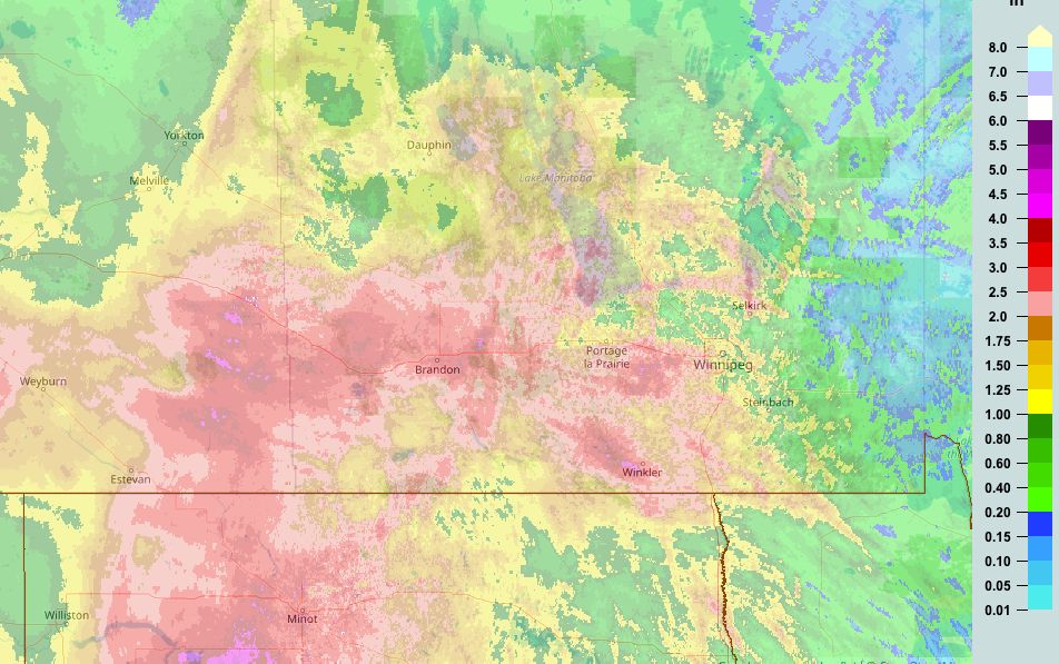
This map shows rainfall estimates from weather radar, which generally match well with gauge measurements.

September 12, 2025 at 4:30 PM
This map shows rainfall estimates from weather radar, which generally match well with gauge measurements.
Another series of training thunderstorms brought a flash flood to SE Manitoba overnight. Up to 150 mm fell in the Steinbach area. The swath of heavy extended from Niverville southeastward to the Ontario border. This rain gauge in Steinbach maxed out at over 5 inches (125 mm).

September 12, 2025 at 4:03 PM
Another series of training thunderstorms brought a flash flood to SE Manitoba overnight. Up to 150 mm fell in the Steinbach area. The swath of heavy extended from Niverville southeastward to the Ontario border. This rain gauge in Steinbach maxed out at over 5 inches (125 mm).
It appears that a strong low-level jet (strong winds in the lower atmosphere) reached nearly 100 km/h just 1-2 km above the ground in southwestern Manitoba. Farther north, this helped create a convergence zone that triggered storms in the Portage la Prairie area.

August 21, 2025 at 2:38 PM
It appears that a strong low-level jet (strong winds in the lower atmosphere) reached nearly 100 km/h just 1-2 km above the ground in southwestern Manitoba. Farther north, this helped create a convergence zone that triggered storms in the Portage la Prairie area.
Training thunderstorms produced heavy rainfall exceeding 100 mm (4 inches) in southern Manitoba overnight. Training storms are analogous to a freight train, as storms repeatedly pass over the same location. But why did this happen?

August 21, 2025 at 2:38 PM
Training thunderstorms produced heavy rainfall exceeding 100 mm (4 inches) in southern Manitoba overnight. Training storms are analogous to a freight train, as storms repeatedly pass over the same location. But why did this happen?
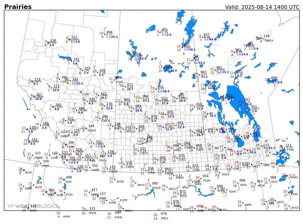
A low-pressure system is bringing some significant rains to northern Saskatchewan and Manitoba today. Great news for the fire situation. The map below shows 24 hr rain totals in bold blue:
August 14, 2025 at 2:48 PM
A low-pressure system is bringing some significant rains to northern Saskatchewan and Manitoba today. Great news for the fire situation. The map below shows 24 hr rain totals in bold blue:
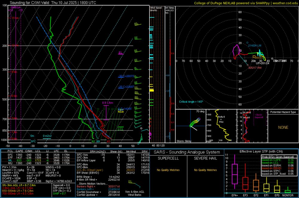
The 18Z weather balloon from the University of Manitoba shows a substantial cap preventing convection over the Red River Valley. However, this cap will weaken as the day progresses and thunderstorms are still possible in southern Manitoba this evening and tonight. #mbstorm
July 10, 2025 at 7:31 PM
The 18Z weather balloon from the University of Manitoba shows a substantial cap preventing convection over the Red River Valley. However, this cap will weaken as the day progresses and thunderstorms are still possible in southern Manitoba this evening and tonight. #mbstorm
A summer storm in southern Manitoba.

June 16, 2025 at 11:45 PM
A summer storm in southern Manitoba.
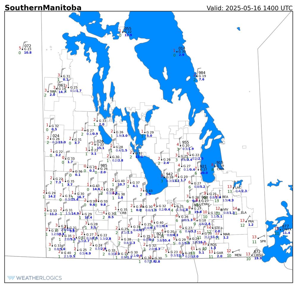
Some of the totals may be past 24 hrs and others may only be since midnight. This map shows storm totals over the past 72 hours, which will give you a better idea:
May 16, 2025 at 4:29 PM
Some of the totals may be past 24 hrs and others may only be since midnight. This map shows storm totals over the past 72 hours, which will give you a better idea:
Southern Manitoba's wild week of weather continues. We started the week with the earliest 100 F (37.8 C) temperature reading in Canadian history. This morning, we have temperatures near 0 C in western Manitoba and perhaps even the odd flake of snow!
May 16, 2025 at 2:47 PM
Southern Manitoba's wild week of weather continues. We started the week with the earliest 100 F (37.8 C) temperature reading in Canadian history. This morning, we have temperatures near 0 C in western Manitoba and perhaps even the odd flake of snow!
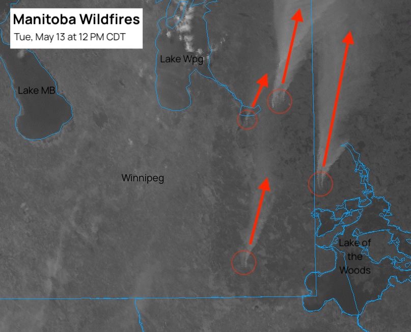
Extreme fire danger continues today in Manitoba with strong southerly winds and temperatures climbing into the thirties. As of 12 PM CDT, there are at least four significant fires burning (circled in red; smoke as arrow) in southeastern MB or adjacent parts of NW Ontario.
May 13, 2025 at 5:13 PM
Extreme fire danger continues today in Manitoba with strong southerly winds and temperatures climbing into the thirties. As of 12 PM CDT, there are at least four significant fires burning (circled in red; smoke as arrow) in southeastern MB or adjacent parts of NW Ontario.
An early heatwave has begun in parts of southern Manitoba. Temperatures at 3PM are sitting in the mid thirties along the US border. Menisino is reading 42 C, but I suspect this is a sensor issue.

May 11, 2025 at 8:59 PM
An early heatwave has begun in parts of southern Manitoba. Temperatures at 3PM are sitting in the mid thirties along the US border. Menisino is reading 42 C, but I suspect this is a sensor issue.
Some isolated thunderstorms are rolling across southern Manitoba this evening. These storms are mostly non-severe, but the odd one is briefly getting up to severe levels with wind gusts approaching 100 km/h and a risk of hail.
May 11, 2025 at 1:57 AM
Some isolated thunderstorms are rolling across southern Manitoba this evening. These storms are mostly non-severe, but the odd one is briefly getting up to severe levels with wind gusts approaching 100 km/h and a risk of hail.
The latest forecast for Sunday through Tuesday shows the potential for a May heatwave!

May 9, 2025 at 2:55 AM
The latest forecast for Sunday through Tuesday shows the potential for a May heatwave!
It's easily the hottest day of 2025 so far in southern Manitoba. As of 3 PM most locations are sitting in the upper twenties, with a few having cracked the 30 C mark. Winnipeg is oh so close, with a high of 29.9 C up to 3 PM.

May 4, 2025 at 8:24 PM
It's easily the hottest day of 2025 so far in southern Manitoba. As of 3 PM most locations are sitting in the upper twenties, with a few having cracked the 30 C mark. Winnipeg is oh so close, with a high of 29.9 C up to 3 PM.
And last Saturday over the northern Lake of the Woods:
May 2, 2025 at 5:31 PM
And last Saturday over the northern Lake of the Woods:
Here's some slightly older imagery from last Saturday over West Hawk/Falcon Lake:

May 2, 2025 at 5:31 PM
Here's some slightly older imagery from last Saturday over West Hawk/Falcon Lake:
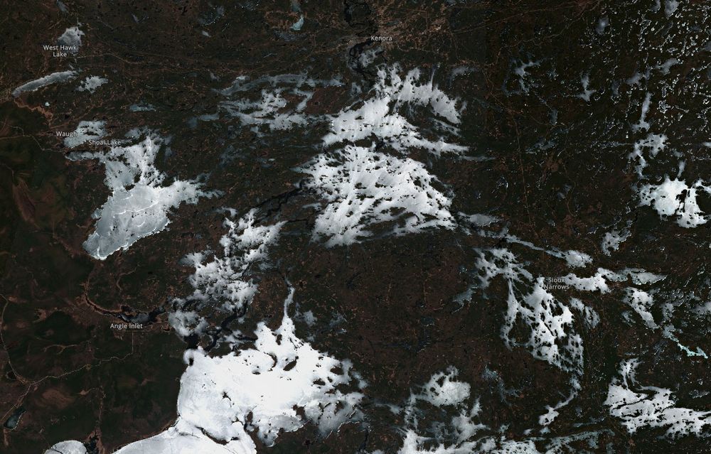
Imagery from the Sentinel-2 satellite on Tuesday showed a lot of ice remaining over the Manitoba lakes. However, much warmer temperatures will arrive starting tomorrow, so that ice won't be around much longer!

May 2, 2025 at 5:31 PM
Imagery from the Sentinel-2 satellite on Tuesday showed a lot of ice remaining over the Manitoba lakes. However, much warmer temperatures will arrive starting tomorrow, so that ice won't be around much longer!
It looks likely that more consistent Spring weather will finally arrive on the Prairies next week. This means temps reaching well into the teens, or maybe even twenties, across MB/SK/AB. However, more cantankerous weather is in store for the rest of this week as winter lingers.
April 2, 2025 at 7:44 PM
It looks likely that more consistent Spring weather will finally arrive on the Prairies next week. This means temps reaching well into the teens, or maybe even twenties, across MB/SK/AB. However, more cantankerous weather is in store for the rest of this week as winter lingers.
Today's clear skies are providing an excellent satellite view of last week's snowfall. You can see an extremely sharp cutoff in snowfall that runs through south Winnipeg. #mbstorm

March 31, 2025 at 8:12 PM
Today's clear skies are providing an excellent satellite view of last week's snowfall. You can see an extremely sharp cutoff in snowfall that runs through south Winnipeg. #mbstorm