


Peter Scarth
@petescarth.bsky.social
🌏 Australian System Scientist | Remote Sensing 🛰️🔍 | Linking spatial data to people 📊 | Building global solutions 🌐 | Data integration & computation at scale 🖥️ | Inspired by big data & rangeland adventures 🌿🚀
My daughter's first Substack post - In our modern world of "spiritual shopping," many of us are engaged in a restless search for belonging—a symptom of cultural homelessness in a society that commodifies meaning but offers no real home.
open.substack.com/pub/amitydel...
open.substack.com/pub/amitydel...

Spiritual shopping, Anthony Bourdain and the fragility of 'home'
Where are we?
open.substack.com
September 5, 2025 at 11:56 AM
My daughter's first Substack post - In our modern world of "spiritual shopping," many of us are engaged in a restless search for belonging—a symptom of cultural homelessness in a society that commodifies meaning but offers no real home.
open.substack.com/pub/amitydel...
open.substack.com/pub/amitydel...
Reposted by Peter Scarth


Reposted by Peter Scarth
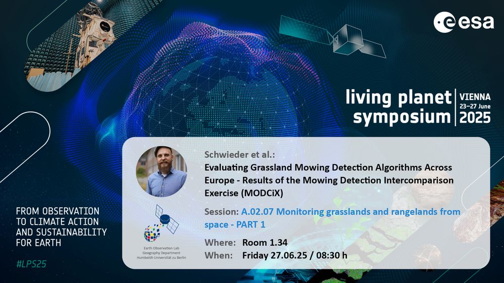
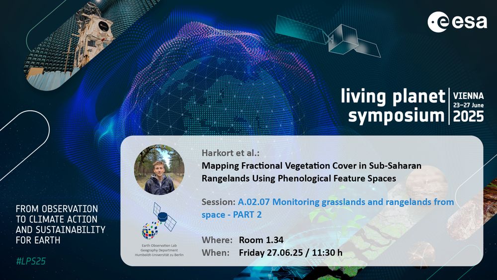
Don’t miss EOLab’s contributions to #LPS25 Session A.02.07 - Monitoring Grasslands and Rangelands from Space
Part 1 with Dr. Marcel Schwieder at 8:30
Part 2 with @lasseharkort.bsky.social at 11:30
See you at Room 1.34!
Part 1 with Dr. Marcel Schwieder at 8:30
Part 2 with @lasseharkort.bsky.social at 11:30
See you at Room 1.34!
June 27, 2025 at 5:12 AM
Don’t miss EOLab’s contributions to #LPS25 Session A.02.07 - Monitoring Grasslands and Rangelands from Space
Part 1 with Dr. Marcel Schwieder at 8:30
Part 2 with @lasseharkort.bsky.social at 11:30
See you at Room 1.34!
Part 1 with Dr. Marcel Schwieder at 8:30
Part 2 with @lasseharkort.bsky.social at 11:30
See you at Room 1.34!
Reposted by Peter Scarth

For those who don't know it yet. There is a feed for Living Planet. You can pin it to your start page. This makes it easy to follow activities around ESA Living Planet.
buff.ly/hBXTBPx
#LPS25 | #EsaLivingPlanet | #LivingPlanetSymposium
#EarthObservation #RemoteSensing
buff.ly/hBXTBPx
#LPS25 | #EsaLivingPlanet | #LivingPlanetSymposium
#EarthObservation #RemoteSensing
June 23, 2025 at 5:35 AM
For those who don't know it yet. There is a feed for Living Planet. You can pin it to your start page. This makes it easy to follow activities around ESA Living Planet.
buff.ly/hBXTBPx
#LPS25 | #EsaLivingPlanet | #LivingPlanetSymposium
#EarthObservation #RemoteSensing
buff.ly/hBXTBPx
#LPS25 | #EsaLivingPlanet | #LivingPlanetSymposium
#EarthObservation #RemoteSensing
New release of Moamosaic (1.0.1) | UBARSC - The UB&A Remote Sensing Centre ubarsc.github.io/update/2025/...
New release of Moamosaic (1.0.1)
Version 1.0.1 release of Moamosaic, a multi-threaded GDAL mosaicing tool.
ubarsc.github.io
April 29, 2025 at 8:07 AM
New release of Moamosaic (1.0.1) | UBARSC - The UB&A Remote Sensing Centre ubarsc.github.io/update/2025/...
Some #ESA #sentinel2 data showing the floodwaters in the outback - this extract covers Noccundra and Thargominda in the north to the Queensland NSW border in the south.

April 10, 2025 at 5:30 AM
Some #ESA #sentinel2 data showing the floodwaters in the outback - this extract covers Noccundra and Thargominda in the north to the Queensland NSW border in the south.
The scale of the flooding in Western Queensland is phenomenal.
Here's a mosaic of MODIS TERRA imagery for 2025-04-04 with water extent in blue and a 600km scale bar for comparison.
Here's a mosaic of MODIS TERRA imagery for 2025-04-04 with water extent in blue and a 600km scale bar for comparison.

April 6, 2025 at 2:34 AM
The scale of the flooding in Western Queensland is phenomenal.
Here's a mosaic of MODIS TERRA imagery for 2025-04-04 with water extent in blue and a 600km scale bar for comparison.
Here's a mosaic of MODIS TERRA imagery for 2025-04-04 with water extent in blue and a 600km scale bar for comparison.
I've been road-testing some #RemoteSensing #LandCondition indicators in #QLD:
🔴 RESTREND (decreasing groundcover relative to rainfall)
🟢 Annual vs Perennial grass (dominance of annuals)
🔵 Landscape Function Index (cover resilience)
Brighter colour combinations = reduced #LandscapeFunction
🔴 RESTREND (decreasing groundcover relative to rainfall)
🟢 Annual vs Perennial grass (dominance of annuals)
🔵 Landscape Function Index (cover resilience)
Brighter colour combinations = reduced #LandscapeFunction

April 4, 2025 at 11:49 PM
I've been road-testing some #RemoteSensing #LandCondition indicators in #QLD:
🔴 RESTREND (decreasing groundcover relative to rainfall)
🟢 Annual vs Perennial grass (dominance of annuals)
🔵 Landscape Function Index (cover resilience)
Brighter colour combinations = reduced #LandscapeFunction
🔴 RESTREND (decreasing groundcover relative to rainfall)
🟢 Annual vs Perennial grass (dominance of annuals)
🔵 Landscape Function Index (cover resilience)
Brighter colour combinations = reduced #LandscapeFunction
Reposted by Peter Scarth
🚨The last chapter of my dissertation is FINALLY out after 5 years in the making! 👀
How does #AMP #grazing impact #soil organic #carbon in CA #rangelands? I collected 1440 soil samples across AMP + conventional ranches in CA to find out
(open access)
www.tandfonline.com/doi/full/10....
How does #AMP #grazing impact #soil organic #carbon in CA #rangelands? I collected 1440 soil samples across AMP + conventional ranches in CA to find out
(open access)
www.tandfonline.com/doi/full/10....

Amping up soil carbon: soil carbon stocks in California rangelands under adaptive multi-paddock and conventional grazing management
Adaptive multi-paddock (AMP) grazing is gaining attention for its potential to increase soil organic carbon (SOC), yet its efficacy on arid and semi-arid rangelands remains debated. Given the adapt...
www.tandfonline.com
February 24, 2025 at 8:04 PM
🚨The last chapter of my dissertation is FINALLY out after 5 years in the making! 👀
How does #AMP #grazing impact #soil organic #carbon in CA #rangelands? I collected 1440 soil samples across AMP + conventional ranches in CA to find out
(open access)
www.tandfonline.com/doi/full/10....
How does #AMP #grazing impact #soil organic #carbon in CA #rangelands? I collected 1440 soil samples across AMP + conventional ranches in CA to find out
(open access)
www.tandfonline.com/doi/full/10....
Reposted by Peter Scarth
Knowledge is never knowing the answer. It’s knowing the territory.
February 18, 2025 at 1:50 AM
Knowledge is never knowing the answer. It’s knowing the territory.
"Dollars in the dust: Is outback scrub really saving the planet?"
The Age newspaper uses drone and multi-temporal satellite imagery to visually tell a (paywalled) story about carbon dynamics in outback Australia.
www.theage.com.au/interactive/...
The Age newspaper uses drone and multi-temporal satellite imagery to visually tell a (paywalled) story about carbon dynamics in outback Australia.
www.theage.com.au/interactive/...

Dollars in the dust: Is outback scrub really saving the planet?
The nation has made a multi-billion dollar bet that carbon locked in desert scrub will offset emissions elsewhere, but doubters are growing from scientists in the city to the farmers on the land.
www.theage.com.au
February 8, 2025 at 11:02 AM
"Dollars in the dust: Is outback scrub really saving the planet?"
The Age newspaper uses drone and multi-temporal satellite imagery to visually tell a (paywalled) story about carbon dynamics in outback Australia.
www.theage.com.au/interactive/...
The Age newspaper uses drone and multi-temporal satellite imagery to visually tell a (paywalled) story about carbon dynamics in outback Australia.
www.theage.com.au/interactive/...
RIOS 2.0.5, with single-pass stats & pyramids | UBARSC - The UB&A Remote Sensing Centre ubarsc.github.io/update/2024/...
RIOS 2.0.5, with single-pass stats & pyramids
The latest RIOS release (2.0.5) includes single-pass calculation of output statistics/histograms/pyramid layers, giving non-trivial speed-ups, especially with large output rasters. See Release Notes f...
ubarsc.github.io
January 12, 2025 at 8:49 AM
RIOS 2.0.5, with single-pass stats & pyramids | UBARSC - The UB&A Remote Sensing Centre ubarsc.github.io/update/2024/...
Reposted by Peter Scarth

Foliage Cover over Australia Ozius Biome - Biome 3D Vegetation Structure 2020
November 21, 2024 at 9:23 AM
Foliage Cover over Australia Ozius Biome - Biome 3D Vegetation Structure 2020
Starting my posts here with a pretty (to me :) map of the first three PLS components of fractional cover time series against soil carbon plots, capturing the contrast between Mitchell Grass, Spinifex, and the Mount Isa Inlier. Next step: pump this through the brilliant www.pyshepseg.org library

November 19, 2024 at 6:47 AM
Starting my posts here with a pretty (to me :) map of the first three PLS components of fractional cover time series against soil carbon plots, capturing the contrast between Mitchell Grass, Spinifex, and the Mount Isa Inlier. Next step: pump this through the brilliant www.pyshepseg.org library