


Earth Observation Lab
@humboldteolab.bsky.social
Humboldt´s Earth Observation Lab focuses on a better understanding of coupled human-environment systems based on remote sensing data and geoinformation.
https://eolab.geographie.hu-berlin.de
https://eolab.geographie.hu-berlin.de
Advancing optical #EarthObservation for #EU policies!
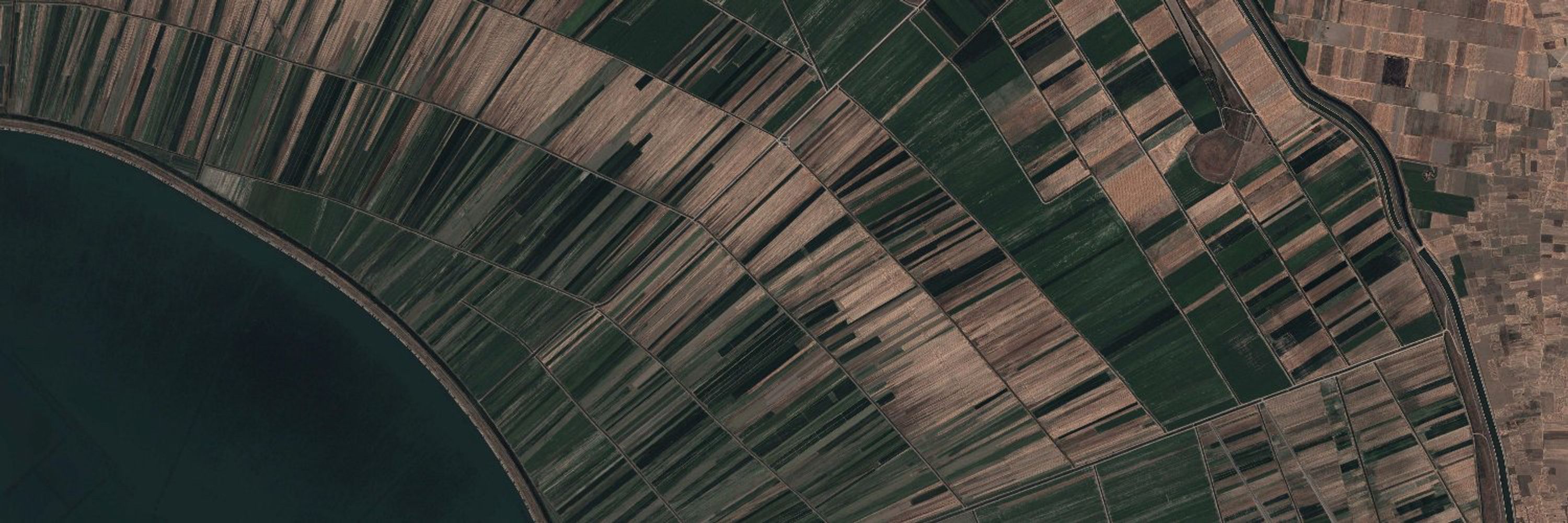
We systematically link EU land-related agricultural & environmental legislation to EO-derived variables from next-generation optical missions (CHIME, Sen-2 NG) and assess their TRLs for operational uptake.
➡️ link.springer.com/article/10.1...
We systematically link EU land-related agricultural & environmental legislation to EO-derived variables from next-generation optical missions (CHIME, Sen-2 NG) and assess their TRLs for operational uptake.
➡️ link.springer.com/article/10.1...

February 16, 2026 at 7:19 AM
Advancing optical #EarthObservation for #EU policies!
We systematically link EU land-related agricultural & environmental legislation to EO-derived variables from next-generation optical missions (CHIME, Sen-2 NG) and assess their TRLs for operational uptake.
➡️ link.springer.com/article/10.1...
We systematically link EU land-related agricultural & environmental legislation to EO-derived variables from next-generation optical missions (CHIME, Sen-2 NG) and assess their TRLs for operational uptake.
➡️ link.springer.com/article/10.1...
How can a “Digital Twin” help to build a more resilient agricultural future?
The #EOAgriTwin project creates virtual replicas of agricultural systems to monitor crop conditions under various stressors.
Explore the tools, use cases and methods in this video!
The #EOAgriTwin project creates virtual replicas of agricultural systems to monitor crop conditions under various stressors.
Explore the tools, use cases and methods in this video!
February 13, 2026 at 7:57 AM
How can a “Digital Twin” help to build a more resilient agricultural future?
The #EOAgriTwin project creates virtual replicas of agricultural systems to monitor crop conditions under various stressors.
Explore the tools, use cases and methods in this video!
The #EOAgriTwin project creates virtual replicas of agricultural systems to monitor crop conditions under various stressors.
Explore the tools, use cases and methods in this video!
From March 24-28, the #FOSSGIS2026 takes place in Göttingen, Germany. There, we will demonstrate how easy it is in #QGIS to evaluate satellite images from hyperspectral sensors, such as #EnMAP, #PRISMA and #Tanager, when using the EnMAP-Box pretalx.com/fossgis2026/...

Hyperspektrale Erdbeobachtung in der Praxis - Die EnMAP-Box in QGIS FOSSGIS-Konferenz 2026
Die EnMAP-Box ist ein QGIS Plugin zur Visualisierung, Analyse und Prozessierung von hyper- und multispektralen Erdbeobachtungsdaten. Unsere Demo zeigt, wie EnMAP-Daten bezogen und in der EnMAP-Box fac...
pretalx.com
February 9, 2026 at 10:30 AM
From March 24-28, the #FOSSGIS2026 takes place in Göttingen, Germany. There, we will demonstrate how easy it is in #QGIS to evaluate satellite images from hyperspectral sensors, such as #EnMAP, #PRISMA and #Tanager, when using the EnMAP-Box pretalx.com/fossgis2026/...
Have you ever wondered how #RemoteSensing and #Geography play together? 🛰️🌍
This Space Time episode explores the past and future of #EarthObservation, featuring former German astronaut Ulrich Walter, ESA Director General @josefaschbacher.esa.int & EOLab’s @hostertp.bsky.social. Subtitles available!
This Space Time episode explores the past and future of #EarthObservation, featuring former German astronaut Ulrich Walter, ESA Director General @josefaschbacher.esa.int & EOLab’s @hostertp.bsky.social. Subtitles available!

BEOBACHTUNG AUS DEM ALL: Jeder Fleck auf der Erde, jeden Tag! SPACETIME S08E03
YouTube video by WELT Space
www.youtube.com
February 6, 2026 at 6:41 AM
Have you ever wondered how #RemoteSensing and #Geography play together? 🛰️🌍
This Space Time episode explores the past and future of #EarthObservation, featuring former German astronaut Ulrich Walter, ESA Director General @josefaschbacher.esa.int & EOLab’s @hostertp.bsky.social. Subtitles available!
This Space Time episode explores the past and future of #EarthObservation, featuring former German astronaut Ulrich Walter, ESA Director General @josefaschbacher.esa.int & EOLab’s @hostertp.bsky.social. Subtitles available!
EOLab’s Florian Poetzschner is presenting current progress of Field delineation and water use assessment for EOAgriTwin - ‘A Digital Twin for Agriculture under multiple stressors’ at ESA's Open Science Meeting in Frascati
Find out more about the project:
www.eoagritwin.eu
Find out more about the project:
www.eoagritwin.eu

February 4, 2026 at 10:46 AM
EOLab’s Florian Poetzschner is presenting current progress of Field delineation and water use assessment for EOAgriTwin - ‘A Digital Twin for Agriculture under multiple stressors’ at ESA's Open Science Meeting in Frascati
Find out more about the project:
www.eoagritwin.eu
Find out more about the project:
www.eoagritwin.eu
The #GreenGrass 2.0 Project aims to enhance the resilience and long-term protection of grassland pasture systems in Germany with smart farming systems.
Check out our new StoryMap to see how #remotesensing helps to develop these sustainable pasture management strategies ➡️ arcg.is/1LOKDC1
Check out our new StoryMap to see how #remotesensing helps to develop these sustainable pasture management strategies ➡️ arcg.is/1LOKDC1

January 25, 2026 at 10:29 AM
The #GreenGrass 2.0 Project aims to enhance the resilience and long-term protection of grassland pasture systems in Germany with smart farming systems.
Check out our new StoryMap to see how #remotesensing helps to develop these sustainable pasture management strategies ➡️ arcg.is/1LOKDC1
Check out our new StoryMap to see how #remotesensing helps to develop these sustainable pasture management strategies ➡️ arcg.is/1LOKDC1
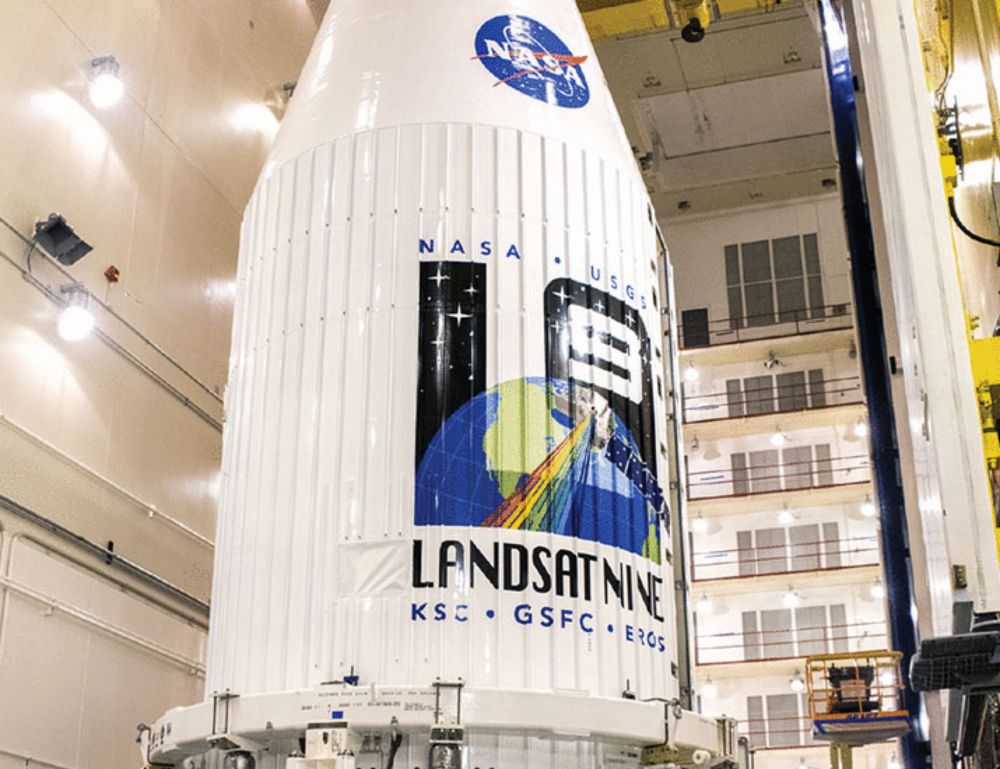
The 2026-2030 #Landsat Science Team met on 20 Jan 2026 for the first time.
EOLab alumni @dfrantz.bsky.social introduced our project on "Synergistic data processing pipelines for Landsat and European satellite missions"
🛰️ Explore the mission and the full team here:
science.nasa.gov/missions/lan...
EOLab alumni @dfrantz.bsky.social introduced our project on "Synergistic data processing pipelines for Landsat and European satellite missions"
🛰️ Explore the mission and the full team here:
science.nasa.gov/missions/lan...

New Landsat Science Team Announced - NASA Science
The U.S. Geological Survey, in cooperation with NASA, has named the new Landsat Science Team that will support the world’s longest-running Earth observation mission for a planned 2026-2030 term.
science.nasa.gov
January 22, 2026 at 9:51 AM
The 2026-2030 #Landsat Science Team met on 20 Jan 2026 for the first time.
EOLab alumni @dfrantz.bsky.social introduced our project on "Synergistic data processing pipelines for Landsat and European satellite missions"
🛰️ Explore the mission and the full team here:
science.nasa.gov/missions/lan...
EOLab alumni @dfrantz.bsky.social introduced our project on "Synergistic data processing pipelines for Landsat and European satellite missions"
🛰️ Explore the mission and the full team here:
science.nasa.gov/missions/lan...
From local fields to national scales: EOLab’s @jalsleben.bsky.social is contributing remote sensing expertise to the interdisciplinary GreenGrass 2.0 Project! 🌱🐄🛰️
Find out more about the project, research challenges, and methodological approaches in this StoryMap:
arcg.is/1LOKDC1
#EarthObservation
Find out more about the project, research challenges, and methodological approaches in this StoryMap:
arcg.is/1LOKDC1
#EarthObservation

January 21, 2026 at 2:53 PM
From local fields to national scales: EOLab’s @jalsleben.bsky.social is contributing remote sensing expertise to the interdisciplinary GreenGrass 2.0 Project! 🌱🐄🛰️
Find out more about the project, research challenges, and methodological approaches in this StoryMap:
arcg.is/1LOKDC1
#EarthObservation
Find out more about the project, research challenges, and methodological approaches in this StoryMap:
arcg.is/1LOKDC1
#EarthObservation
On Jan 29.+30, the German Space Agency will hold a webinar on the Applications and Commercialization Potential of #EnMAP. The webinar also shows how EnMAP data can be obtained and processed using the EnMAP-Box in #QGIS
www.enmap.org/data/news/En...
www.enmap.org/data/news/En...
www.enmap.org
December 15, 2025 at 8:19 AM
On Jan 29.+30, the German Space Agency will hold a webinar on the Applications and Commercialization Potential of #EnMAP. The webinar also shows how EnMAP data can be obtained and processed using the EnMAP-Box in #QGIS
www.enmap.org/data/news/En...
www.enmap.org/data/news/En...
Exciting times for #EOAgriTwin project! Join the first webinar on the latest developments in a @esa.int #EarthObservation Digital Twin for #agriculture under stressors in #Europe!
Join us for the upcoming #EOAgriTwin webinar focusing on the latest progress of our #DigitalTwin Component for agriculture. We will share the current status and demonstrate key capabilities.
📅 13 January 2026, 13:00
Registration: www.eoagritwin.eu/webinar
@zalf.bsky.social
📅 13 January 2026, 13:00
Registration: www.eoagritwin.eu/webinar
@zalf.bsky.social

December 8, 2025 at 7:40 PM
Exciting times for #EOAgriTwin project! Join the first webinar on the latest developments in a @esa.int #EarthObservation Digital Twin for #agriculture under stressors in #Europe!
Reposted by Earth Observation Lab

2025 GDAL User Survey is now active for the entire month of December! Visit gdal.org/survey/ & tell the project how you use it, where you get help, what it should do in the future, & how/if it should use LLMs going forward. (optionally) give us your email, we'll even enter you to win a GDAL t-shirt!

2025 GDAL User Survey
In 2024, the GDAL User Survey solicited feedback to help focus GDAL Sponsorship Program activities. Your contribution mattered. Last years' results triggered the project to embark on the GDAL CLI Mode...
gdal.org
December 1, 2025 at 3:32 PM
2025 GDAL User Survey is now active for the entire month of December! Visit gdal.org/survey/ & tell the project how you use it, where you get help, what it should do in the future, & how/if it should use LLMs going forward. (optionally) give us your email, we'll even enter you to win a GDAL t-shirt!
We just released EnMAP-Box 3.17.1, bringing numerous new features and improvements. For example, the new Spectral Index Explorer visualizes numerous spectral indices on-the-fly with just a mouse click. #EnMAP #Hyperspectral #ImagingSpectroscopy
December 8, 2025 at 8:39 AM
We just released EnMAP-Box 3.17.1, bringing numerous new features and improvements. For example, the new Spectral Index Explorer visualizes numerous spectral indices on-the-fly with just a mouse click. #EnMAP #Hyperspectral #ImagingSpectroscopy
The 14th EARSeL Workshop on Imaging Spectroscopy will take place in Helsinki, Finnland, from 2-4. Jun 2026. It is followed by a tutorial day on 5. June. There we will show the EnMAP-Box and how to use it for visualizing and analyzing EnMAP and other EO datasets.
is.earsel.org/workshop/14-...
is.earsel.org/workshop/14-...
December 1, 2025 at 11:14 AM
The 14th EARSeL Workshop on Imaging Spectroscopy will take place in Helsinki, Finnland, from 2-4. Jun 2026. It is followed by a tutorial day on 5. June. There we will show the EnMAP-Box and how to use it for visualizing and analyzing EnMAP and other EO datasets.
is.earsel.org/workshop/14-...
is.earsel.org/workshop/14-...
@jakimowb.bsky.social presented the #EnMAP-Box and the EO Time Series Viewer at ESA #BiDS25 in Riga, Latvia.
Thanks to the QGIS API, these QGIS plugins allow for an integrated and interactive display of raster data, facilitating the creation of reference data for model training and validation.
Thanks to the QGIS API, these QGIS plugins allow for an integrated and interactive display of raster data, facilitating the creation of reference data for model training and validation.

October 7, 2025 at 9:35 AM
@jakimowb.bsky.social presented the #EnMAP-Box and the EO Time Series Viewer at ESA #BiDS25 in Riga, Latvia.
Thanks to the QGIS API, these QGIS plugins allow for an integrated and interactive display of raster data, facilitating the creation of reference data for model training and validation.
Thanks to the QGIS API, these QGIS plugins allow for an integrated and interactive display of raster data, facilitating the creation of reference data for model training and validation.
Reposted by Earth Observation Lab
Want to do a PhD in remote sensing? Interested in mountain forest ecosystems? Then apply for a PhD position in our lab! You will be part of the newly founded Centre for Forest Management in the Alps, working on scaling tree productivity from tree to landscape scale. Deadline 21st September.


September 4, 2025 at 11:55 AM
Want to do a PhD in remote sensing? Interested in mountain forest ecosystems? Then apply for a PhD position in our lab! You will be part of the newly founded Centre for Forest Management in the Alps, working on scaling tree productivity from tree to landscape scale. Deadline 21st September.
Using Remote Sensing and Agro-Ecosystem Modelling 🛰️🌽📈, Esther Shupel Ibrahim analyzes impacts of climate change and diseases on smallholder agriculture in Nigeria and develops strategies to support and empower smallholder farmers.
Find out more about her PhD research in this StoryMap:
arcg.is/1bG48K
Find out more about her PhD research in this StoryMap:
arcg.is/1bG48K
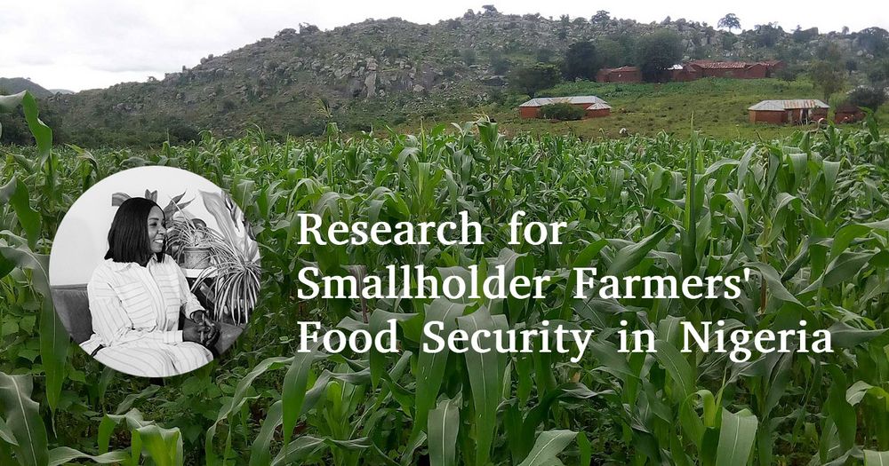
July 21, 2025 at 11:09 AM
Using Remote Sensing and Agro-Ecosystem Modelling 🛰️🌽📈, Esther Shupel Ibrahim analyzes impacts of climate change and diseases on smallholder agriculture in Nigeria and develops strategies to support and empower smallholder farmers.
Find out more about her PhD research in this StoryMap:
arcg.is/1bG48K
Find out more about her PhD research in this StoryMap:
arcg.is/1bG48K
Reposted by Earth Observation Lab
🌍 🛰️ 🌱 🌽👨🏿🌾🛖💻⚙️
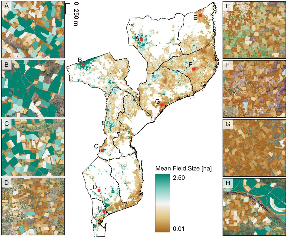
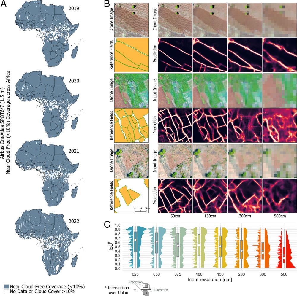
Preprint on national-scale satellite-based crop field delineation in smallholder landscapes is out:
doi.org/10.48550/arX...
🌍 🛰️ 🌱 🌽👨🏿🌾🛖💻⚙️
Preprint on national-scale satellite-based crop field delineation in smallholder landscapes is out:
doi.org/10.48550/arX...
🌍 🛰️ 🌱 🌽👨🏿🌾🛖💻⚙️
July 17, 2025 at 10:25 AM
🌍 🛰️ 🌱 🌽👨🏿🌾🛖💻⚙️
Preprint on national-scale satellite-based crop field delineation in smallholder landscapes is out:
doi.org/10.48550/arX...
🌍 🛰️ 🌱 🌽👨🏿🌾🛖💻⚙️
Preprint on national-scale satellite-based crop field delineation in smallholder landscapes is out:
doi.org/10.48550/arX...
🌍 🛰️ 🌱 🌽👨🏿🌾🛖💻⚙️
Reposted by Earth Observation Lab
The #Landsat program is arguable THE most important satellite mission for ecology, land-system science and sustainability science (and many other fields). It must stay science-oriented. Open access is crucial.
Independent oversight crucial to Landsat Next | Science www.science.org/doi/10.1126/...
Independent oversight crucial to Landsat Next | Science www.science.org/doi/10.1126/...
Independent oversight crucial to Landsat Next
www.science.org
June 6, 2025 at 5:58 AM
The #Landsat program is arguable THE most important satellite mission for ecology, land-system science and sustainability science (and many other fields). It must stay science-oriented. Open access is crucial.
Independent oversight crucial to Landsat Next | Science www.science.org/doi/10.1126/...
Independent oversight crucial to Landsat Next | Science www.science.org/doi/10.1126/...
Reposted by Earth Observation Lab
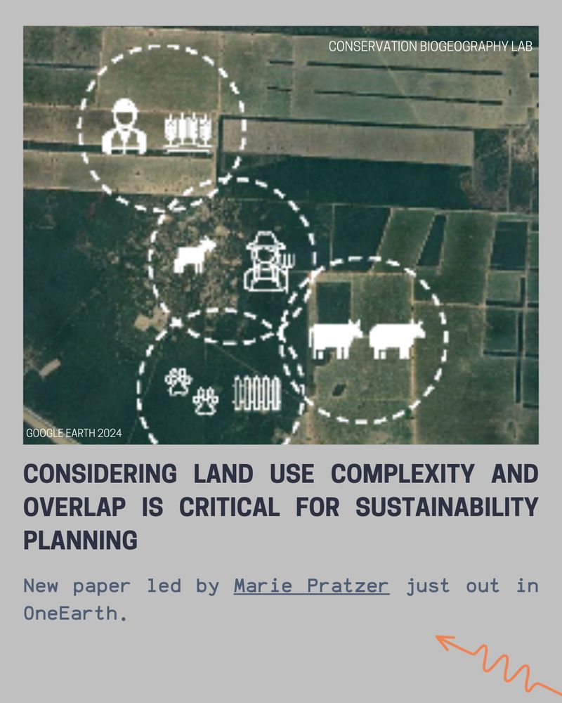
Considering land use complexity and overlap is critical for sustainability planning. New paper led by Marie Pratzer - out in OneEarth:
www.sciencedirect.com/science/arti...
@tkuemmerle.bsky.social @matthiasbaumann.bsky.social @pedrofernandez91.bsky.social @oneearthofficial.bsky.social
www.sciencedirect.com/science/arti...
@tkuemmerle.bsky.social @matthiasbaumann.bsky.social @pedrofernandez91.bsky.social @oneearthofficial.bsky.social
April 7, 2025 at 7:30 AM
Considering land use complexity and overlap is critical for sustainability planning. New paper led by Marie Pratzer - out in OneEarth:
www.sciencedirect.com/science/arti...
@tkuemmerle.bsky.social @matthiasbaumann.bsky.social @pedrofernandez91.bsky.social @oneearthofficial.bsky.social
www.sciencedirect.com/science/arti...
@tkuemmerle.bsky.social @matthiasbaumann.bsky.social @pedrofernandez91.bsky.social @oneearthofficial.bsky.social
Reposted by Earth Observation Lab
#LPS25 was a fantastic experience but let´s take a step back and reflect on the potential (and the role) of commercial EO data providers in contributing to pressing #sustainability challenges. Here´s a short recap of arguments from the scientific community: doi.org/10.1073/pnas...
To enhance sustainable development goal research, open up commercial satellite image archives | PNAS
To enhance sustainable development goal research, open up commercial satellite image
archives
doi.org
June 30, 2025 at 11:34 AM
#LPS25 was a fantastic experience but let´s take a step back and reflect on the potential (and the role) of commercial EO data providers in contributing to pressing #sustainability challenges. Here´s a short recap of arguments from the scientific community: doi.org/10.1073/pnas...

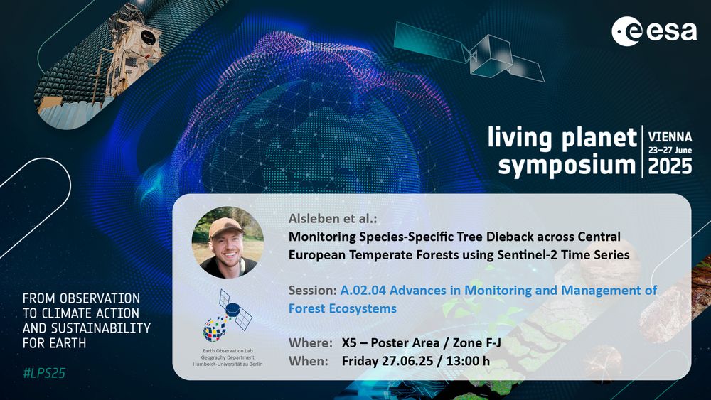
How well can we map NPV across temperate forest heterogeneity? Can we use NPV time series to reveal tree dieback? And how does dieback vary between species in Germany?
Visit @jalsleben.bsky.social to discuss these questions:
📍 X5 Poster Area
🗓️ Friday, 13:00h
#LPS25 #Sentinel2 #foresthealth
Visit @jalsleben.bsky.social to discuss these questions:
📍 X5 Poster Area
🗓️ Friday, 13:00h
#LPS25 #Sentinel2 #foresthealth
June 27, 2025 at 10:17 AM
How well can we map NPV across temperate forest heterogeneity? Can we use NPV time series to reveal tree dieback? And how does dieback vary between species in Germany?
Visit @jalsleben.bsky.social to discuss these questions:
📍 X5 Poster Area
🗓️ Friday, 13:00h
#LPS25 #Sentinel2 #foresthealth
Visit @jalsleben.bsky.social to discuss these questions:
📍 X5 Poster Area
🗓️ Friday, 13:00h
#LPS25 #Sentinel2 #foresthealth
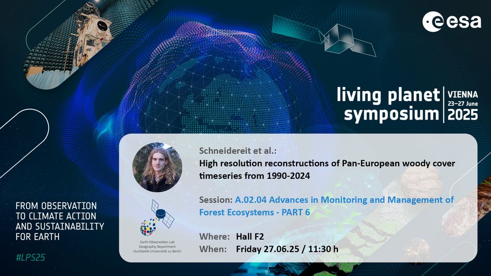
#LPS25 wildE presentation on High resolution reconstructions of Pan-European woody cover timeseries from 1990-2024 by Shawn Schneidereit upcoming in Hall F2 at 11:30h!
June 27, 2025 at 8:36 AM
#LPS25 wildE presentation on High resolution reconstructions of Pan-European woody cover timeseries from 1990-2024 by Shawn Schneidereit upcoming in Hall F2 at 11:30h!
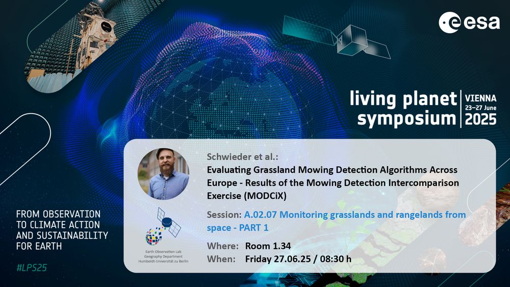
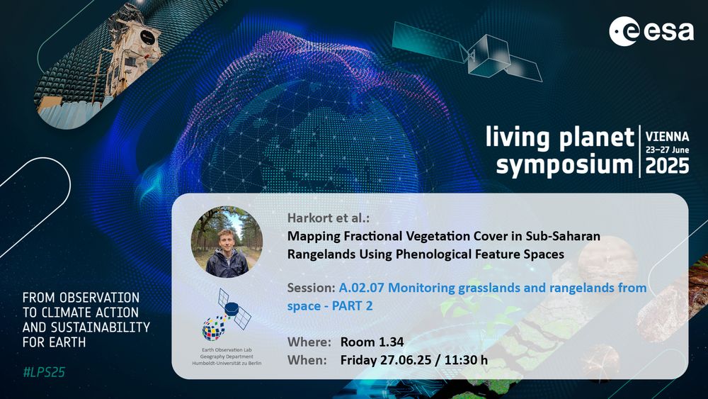
Don’t miss EOLab’s contributions to #LPS25 Session A.02.07 - Monitoring Grasslands and Rangelands from Space
Part 1 with Dr. Marcel Schwieder at 8:30
Part 2 with @lasseharkort.bsky.social at 11:30
See you at Room 1.34!
Part 1 with Dr. Marcel Schwieder at 8:30
Part 2 with @lasseharkort.bsky.social at 11:30
See you at Room 1.34!
June 27, 2025 at 5:12 AM
Don’t miss EOLab’s contributions to #LPS25 Session A.02.07 - Monitoring Grasslands and Rangelands from Space
Part 1 with Dr. Marcel Schwieder at 8:30
Part 2 with @lasseharkort.bsky.social at 11:30
See you at Room 1.34!
Part 1 with Dr. Marcel Schwieder at 8:30
Part 2 with @lasseharkort.bsky.social at 11:30
See you at Room 1.34!
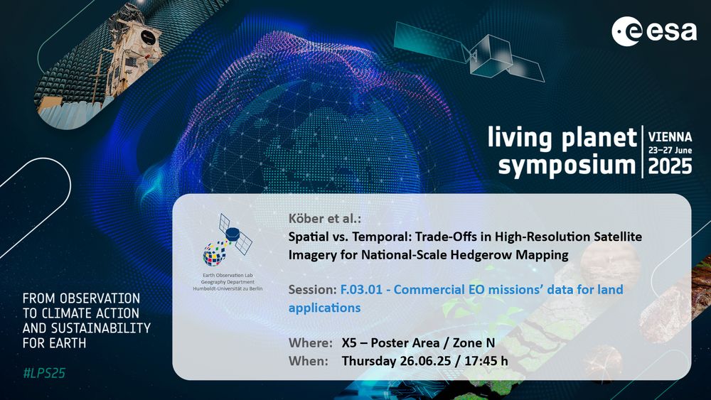
Find two more Earth Observation Lab contributions by Dr. David Frantz and Anna Köber at today’s #LPS25 Poster Sessions!
📍 X5 Poster Area - Zone N & O
🗓️ 26.06.25, 17:45 h
📍 X5 Poster Area - Zone N & O
🗓️ 26.06.25, 17:45 h

June 26, 2025 at 12:02 PM
Find two more Earth Observation Lab contributions by Dr. David Frantz and Anna Köber at today’s #LPS25 Poster Sessions!
📍 X5 Poster Area - Zone N & O
🗓️ 26.06.25, 17:45 h
📍 X5 Poster Area - Zone N & O
🗓️ 26.06.25, 17:45 h