


Patrick Duplessis
@patwx.bsky.social
[FR/EN] Météorologue à MétéoMédia | PhD Candidate at Dalhousie University | Intérêts: Canadian weather maps, stats and news
While January 2026 was a cold one in most of Ontario and Southern Quebec, warmer temperatures dominated elsewhere. Baffin Island and Ellesmere Island had their warmest January on record, with up to 11.4° above normal for Iqaluit - improving last year's record by more than a degree!

February 1, 2026 at 5:42 PM
While January 2026 was a cold one in most of Ontario and Southern Quebec, warmer temperatures dominated elsewhere. Baffin Island and Ellesmere Island had their warmest January on record, with up to 11.4° above normal for Iqaluit - improving last year's record by more than a degree!
The northernmost station in Canada, Alert, climbed above freezing this morning to a high of 0.9°C!
This is the warmest temperature recorded up there in January since records began in 1951. #Arctic
Previous daily record: -13.8°C (2003)
Previous January record: 0.0°C (1958)
This is the warmest temperature recorded up there in January since records began in 1951. #Arctic
Previous daily record: -13.8°C (2003)
Previous January record: 0.0°C (1958)

January 6, 2026 at 3:33 PM
The northernmost station in Canada, Alert, climbed above freezing this morning to a high of 0.9°C!
This is the warmest temperature recorded up there in January since records began in 1951. #Arctic
Previous daily record: -13.8°C (2003)
Previous January record: 0.0°C (1958)
This is the warmest temperature recorded up there in January since records began in 1951. #Arctic
Previous daily record: -13.8°C (2003)
Previous January record: 0.0°C (1958)
Reposted by Patrick Duplessis
Alaska and vicinity temperature December departures from the 1991-2020 baseline normal. Bering Sea on the warm side of normal, especially St. Lawrence Island. Cold most other regions, especially eastern Interior and the Yukon Territory. #akwx #Climate @climatologist49.bsky.social @patwx.bsky.social

January 2, 2026 at 12:08 AM
Alaska and vicinity temperature December departures from the 1991-2020 baseline normal. Bering Sea on the warm side of normal, especially St. Lawrence Island. Cold most other regions, especially eastern Interior and the Yukon Territory. #akwx #Climate @climatologist49.bsky.social @patwx.bsky.social
For once, December 2025 was a cold month across most of Canada. Repeated events of extreme cold in Yukon brought monthly temperatures more than 13° below normal! Coldest December since 1980 for Whitehorse and Old Crow, and since 2013 for Yellowknife.

January 1, 2026 at 5:31 PM
For once, December 2025 was a cold month across most of Canada. Repeated events of extreme cold in Yukon brought monthly temperatures more than 13° below normal! Coldest December since 1980 for Whitehorse and Old Crow, and since 2013 for Yellowknife.
November 2025 was very warm overall in Canada, with record-breaking averages in some places. However, southern Ontario and Quebec managed to get below average temperatures. Most of Ontario and Quebec also had more snowfall than normal.

December 1, 2025 at 4:33 PM
November 2025 was very warm overall in Canada, with record-breaking averages in some places. However, southern Ontario and Quebec managed to get below average temperatures. Most of Ontario and Quebec also had more snowfall than normal.
Our latest paper was published today in Open Access!
Full article: Linking Marine Fog Variability in Atlantic Canada to Changes in Large-Scale Atmospheric and Marine Features www.tandfonline.com/doi/full/10....
Full article: Linking Marine Fog Variability in Atlantic Canada to Changes in Large-Scale Atmospheric and Marine Features www.tandfonline.com/doi/full/10....

Linking Marine Fog Variability in Atlantic Canada to Changes in Large-Scale Atmospheric and Marine Features
Marine fog varies on annual, decadal, and climate change scales, with implications on transportation and the global radiative budget. Using reanalysis and airport meteorological data from 1953 to 2...
www.tandfonline.com
November 25, 2025 at 8:47 PM
Our latest paper was published today in Open Access!
Full article: Linking Marine Fog Variability in Atlantic Canada to Changes in Large-Scale Atmospheric and Marine Features www.tandfonline.com/doi/full/10....
Full article: Linking Marine Fog Variability in Atlantic Canada to Changes in Large-Scale Atmospheric and Marine Features www.tandfonline.com/doi/full/10....
Eureka, Nunavut (NEK) hit -30.5°C in the past hour, making it the first -30° of the season in Canada, close to two weeks later than normal.
The average date of first -30° in Eureka for 1991-2020 is Oct 21.
The average date of first -30° in Eureka for 1991-2020 is Oct 21.


November 2, 2025 at 3:08 PM
Eureka, Nunavut (NEK) hit -30.5°C in the past hour, making it the first -30° of the season in Canada, close to two weeks later than normal.
The average date of first -30° in Eureka for 1991-2020 is Oct 21.
The average date of first -30° in Eureka for 1991-2020 is Oct 21.
Canada had a very warm October, except in BC with near to slightly below seasonal temperatures.
Record-warmest October for:
Cambridge Bay -2.5° (previously -2.9 in 2021/2023)
Churchill 4.7° (4.0 in 2021)
Kuujjuaq 5.4° (3.8 in 2021)
Nain 7.1° (5.3 in 2023)
Wabush 4.9° (4.8 in 2022)
Record-warmest October for:
Cambridge Bay -2.5° (previously -2.9 in 2021/2023)
Churchill 4.7° (4.0 in 2021)
Kuujjuaq 5.4° (3.8 in 2021)
Nain 7.1° (5.3 in 2023)
Wabush 4.9° (4.8 in 2022)

November 1, 2025 at 3:19 PM
Canada had a very warm October, except in BC with near to slightly below seasonal temperatures.
Record-warmest October for:
Cambridge Bay -2.5° (previously -2.9 in 2021/2023)
Churchill 4.7° (4.0 in 2021)
Kuujjuaq 5.4° (3.8 in 2021)
Nain 7.1° (5.3 in 2023)
Wabush 4.9° (4.8 in 2022)
Record-warmest October for:
Cambridge Bay -2.5° (previously -2.9 in 2021/2023)
Churchill 4.7° (4.0 in 2021)
Kuujjuaq 5.4° (3.8 in 2021)
Nain 7.1° (5.3 in 2023)
Wabush 4.9° (4.8 in 2022)
More monthly heat records in Eastern Canada today. Close to 30°C in Nova Scotia once again!

October 7, 2025 at 8:23 PM
More monthly heat records in Eastern Canada today. Close to 30°C in Nova Scotia once again!
Several October records were broken today in Ontario and Québec, up to 31.7° in Luskville, QC (new provincial October record)!
A few missed records:
Ottawa 29.9° (1.0° from record of 2023)
Quebec City 26.7° (1.6° from record of 1949)
Moosonee 29.0° (1.0° from record of 2023)
A few missed records:
Ottawa 29.9° (1.0° from record of 2023)
Quebec City 26.7° (1.6° from record of 1949)
Moosonee 29.0° (1.0° from record of 2023)

October 6, 2025 at 2:48 AM
Several October records were broken today in Ontario and Québec, up to 31.7° in Luskville, QC (new provincial October record)!
A few missed records:
Ottawa 29.9° (1.0° from record of 2023)
Quebec City 26.7° (1.6° from record of 1949)
Moosonee 29.0° (1.0° from record of 2023)
A few missed records:
Ottawa 29.9° (1.0° from record of 2023)
Quebec City 26.7° (1.6° from record of 1949)
Moosonee 29.0° (1.0° from record of 2023)
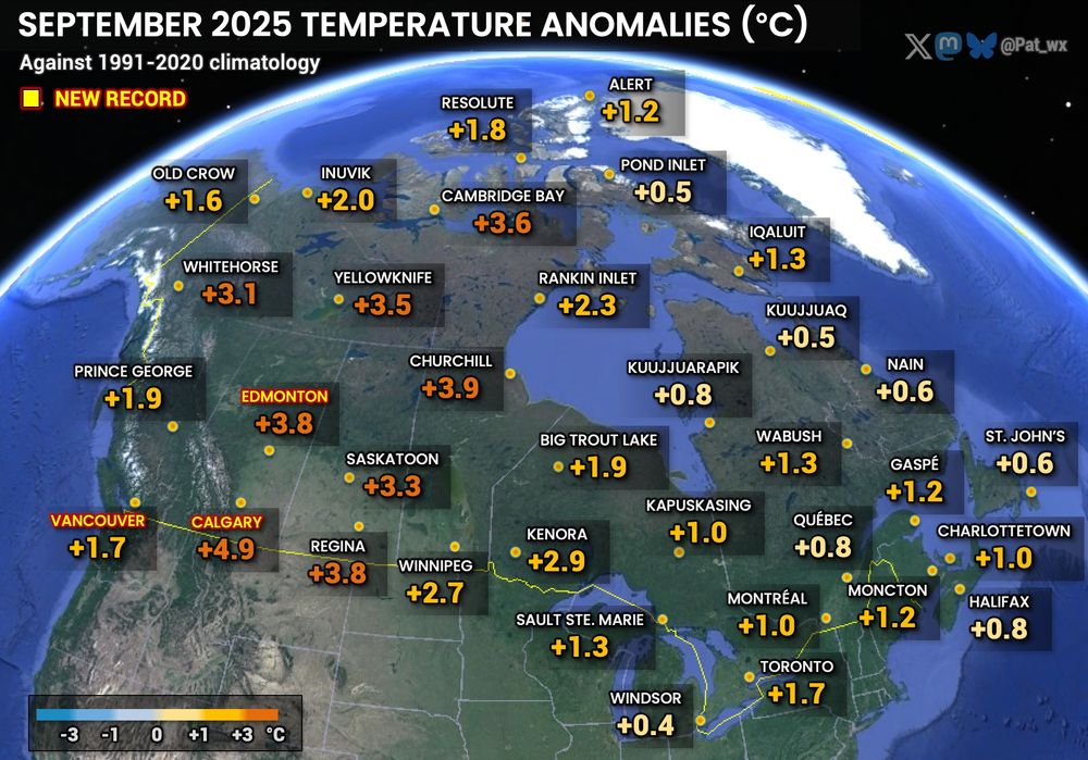
September 2025 was warmer than normal everywhere in Canada. The strongest anomalies were in the Prairies and territories, and it was the hottest September on record in Vancouver, Calgary and Edmonton.
October 1, 2025 at 1:32 PM
September 2025 was warmer than normal everywhere in Canada. The strongest anomalies were in the Prairies and territories, and it was the hottest September on record in Vancouver, Calgary and Edmonton.
August 2025 was slightly warmer than normal overall in Canada. The warmest anomalies were observed in the Yukon, NWT, and Prairies. Meanwhile a few cold anomalies stand out in SW Ontario and parts of Nunavut.

September 1, 2025 at 3:13 PM
August 2025 was slightly warmer than normal overall in Canada. The warmest anomalies were observed in the Yukon, NWT, and Prairies. Meanwhile a few cold anomalies stand out in SW Ontario and parts of Nunavut.
Reposted by Patrick Duplessis

Alaska's summer (Jun-Aug) was slightly warmer and slightly wetter than the 1991-2020 normal. @alaskawx.bsky.social


September 1, 2025 at 2:55 PM
Alaska's summer (Jun-Aug) was slightly warmer and slightly wetter than the 1991-2020 normal. @alaskawx.bsky.social
Another all-time record was set today in Eastern Canada!
30.3° Havre-Saint-Pierre, QC (previously 30,0° 1987/07/14)
36.3° (prelim.) in Goose Bay: New August Labrador record!
Very impressive 35.7° in Cartwright, too! August record for the station. #NLwx
30.3° Havre-Saint-Pierre, QC (previously 30,0° 1987/07/14)
36.3° (prelim.) in Goose Bay: New August Labrador record!
Very impressive 35.7° in Cartwright, too! August record for the station. #NLwx

August 13, 2025 at 10:36 PM
Another all-time record was set today in Eastern Canada!
30.3° Havre-Saint-Pierre, QC (previously 30,0° 1987/07/14)
36.3° (prelim.) in Goose Bay: New August Labrador record!
Very impressive 35.7° in Cartwright, too! August record for the station. #NLwx
30.3° Havre-Saint-Pierre, QC (previously 30,0° 1987/07/14)
36.3° (prelim.) in Goose Bay: New August Labrador record!
Very impressive 35.7° in Cartwright, too! August record for the station. #NLwx
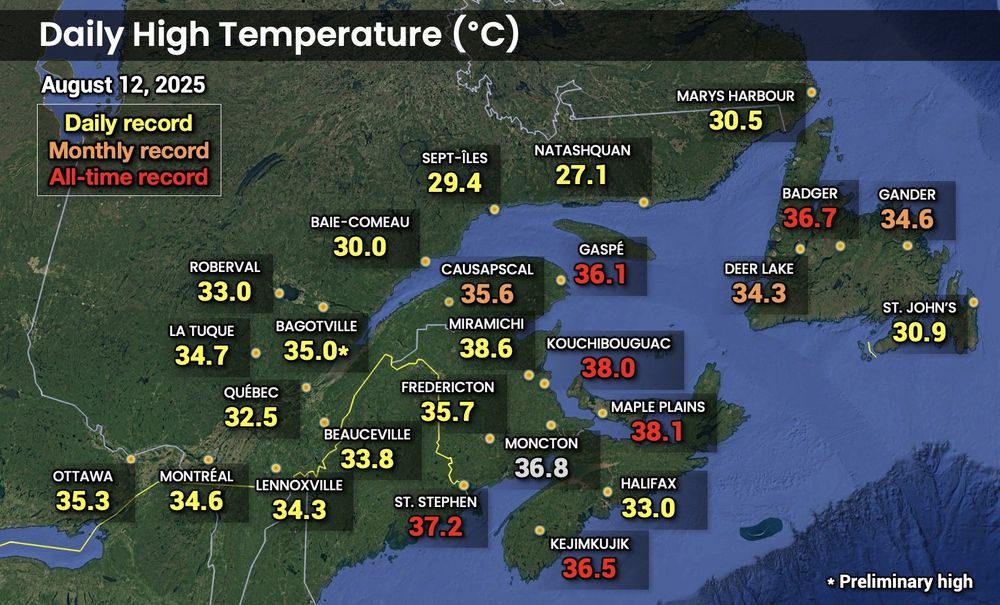
Even hotter than yesterday in Eastern Canada!
All-time records were set at several stations, and the all-time PEI record was shattered with 38.1° at Maple Plains!
36.7° in Badger, NL tied August record for NL and all-time record for the island. 38.6° in Miramichi is 0.8° below NB all-time record. ♨️
All-time records were set at several stations, and the all-time PEI record was shattered with 38.1° at Maple Plains!
36.7° in Badger, NL tied August record for NL and all-time record for the island. 38.6° in Miramichi is 0.8° below NB all-time record. ♨️
August 12, 2025 at 11:21 PM
Even hotter than yesterday in Eastern Canada!
All-time records were set at several stations, and the all-time PEI record was shattered with 38.1° at Maple Plains!
36.7° in Badger, NL tied August record for NL and all-time record for the island. 38.6° in Miramichi is 0.8° below NB all-time record. ♨️
All-time records were set at several stations, and the all-time PEI record was shattered with 38.1° at Maple Plains!
36.7° in Badger, NL tied August record for NL and all-time record for the island. 38.6° in Miramichi is 0.8° below NB all-time record. ♨️

July 2025 was a mixed bag in #Canada. Generally hotter than normal in the east, but slightly cooler in many regions. Northern Nunavut had the coldest anomalies, between 1° and 2°C below the 1991-2020 average.

August 1, 2025 at 2:16 PM
July 2025 was a mixed bag in #Canada. Generally hotter than normal in the east, but slightly cooler in many regions. Northern Nunavut had the coldest anomalies, between 1° and 2°C below the 1991-2020 average.
June 2025 was generally warmer than normal in Canada, although most stations were within 1° of their 1991-2020 normal. Atlantic Canada got the warmest anomalies, up to 3.5° above normal in St. John's, NL.

July 1, 2025 at 5:35 PM
June 2025 was generally warmer than normal in Canada, although most stations were within 1° of their 1991-2020 normal. Atlantic Canada got the warmest anomalies, up to 3.5° above normal in St. John's, NL.
May 2025 was a bit of a mixed bag across Canada. Very warm in the Prairies and parts of the north. Very cool in Yukon and adjacent NWT, and cooler than normal in northern QC and southern ON.

June 1, 2025 at 5:37 PM
May 2025 was a bit of a mixed bag across Canada. Very warm in the Prairies and parts of the north. Very cool in Yukon and adjacent NWT, and cooler than normal in northern QC and southern ON.
April 2025 was generally warmer than normal across Canada, but cooler in parts of Quebec, Northern Ontario and Manitoba, and Southern Nunavut. The month was more notable for its strong temperature swings than its overall anomaly.

May 1, 2025 at 6:06 PM
April 2025 was generally warmer than normal across Canada, but cooler in parts of Quebec, Northern Ontario and Manitoba, and Southern Nunavut. The month was more notable for its strong temperature swings than its overall anomaly.
March 2025 was warmer than normal for most of #Canada, except for a region extending from the NWT to Labrador, which was colder than normal. The strongest anomalies were in Northern Nunavut; up to +6.5°C for Pond Inlet.

April 1, 2025 at 4:35 PM
March 2025 was warmer than normal for most of #Canada, except for a region extending from the NWT to Labrador, which was colder than normal. The strongest anomalies were in Northern Nunavut; up to +6.5°C for Pond Inlet.
Meteorological winter 2025 was overall near normal for Southern QC and ON and most of the Maritimes, colder than normal in parts of the Prairies, and broadly much above normal in northern Canada.

March 3, 2025 at 4:30 PM
Meteorological winter 2025 was overall near normal for Southern QC and ON and most of the Maritimes, colder than normal in parts of the Prairies, and broadly much above normal in northern Canada.
February 2025 was colder than normal for most Canadians, up to more than 6° below the 1991-2020 average in Southern AB and SK. Meanwhile, record-warmest February for Resolute and Alert in the extreme north.

March 2, 2025 at 8:37 PM
February 2025 was colder than normal for most Canadians, up to more than 6° below the 1991-2020 average in Southern AB and SK. Meanwhile, record-warmest February for Resolute and Alert in the extreme north.

January 2025 was warm for most of Canada. Warmest on record for Kuujjuaq and Iqaluit with an almost +11°C anomaly. The month was colder than normal in Southern Ontario and SE BC, and near normal at the northernmost point.

February 1, 2025 at 6:35 PM
January 2025 was warm for most of Canada. Warmest on record for Kuujjuaq and Iqaluit with an almost +11°C anomaly. The month was colder than normal in Southern Ontario and SE BC, and near normal at the northernmost point.