


Nick Millea
@milleanick.bsky.social
Map Curator at the Bodleian, University of Oxford; Hon Fellow, Royal Scottish Geographical Society; Chair, Charlbury Beer Festival (2020); Cyclist ...
Time for another @bodleian.ox.ac.uk #Maps blog from @stuartackland.bsky.social exploring the C17 work of John Speed, emphasising his imagery of historical events. Go to blogs.bodleian.ox.ac.uk/maps/ to find out what (or who) is being transported here ... @bcsmaps.bsky.social @imagomundi.bsky.social


February 2, 2026 at 4:07 PM
Time for another @bodleian.ox.ac.uk #Maps blog from @stuartackland.bsky.social exploring the C17 work of John Speed, emphasising his imagery of historical events. Go to blogs.bodleian.ox.ac.uk/maps/ to find out what (or who) is being transported here ... @bcsmaps.bsky.social @imagomundi.bsky.social
Reposted by Nick Millea
In Speed's atlas, 1611, is this image, with text 'But success of warr altering Maud the Emperese to save her owne life adventured to throwe the host her enimie, layde in a coffin fayned to be dead, and soe was carryed in a horse litter from Winchester'. Maud's escape was in 1141 @bodleian.ox.ac.uk

January 29, 2026 at 4:11 PM
In Speed's atlas, 1611, is this image, with text 'But success of warr altering Maud the Emperese to save her owne life adventured to throwe the host her enimie, layde in a coffin fayned to be dead, and soe was carryed in a horse litter from Winchester'. Maud's escape was in 1141 @bodleian.ox.ac.uk
Reposted by Nick Millea
Join us next month to find out how Canterbury's past was investigated for the new Historic Towns Atlas!
This webinar is in collaboration with the Historic Towns Trust @historictownstrust.bsky.social
Find out more: www.balh.org.uk/event-balh-i...
#WeAreLocalHistory #LocalHistoryForAll
This webinar is in collaboration with the Historic Towns Trust @historictownstrust.bsky.social
Find out more: www.balh.org.uk/event-balh-i...
#WeAreLocalHistory #LocalHistoryForAll

January 30, 2026 at 8:01 AM
Join us next month to find out how Canterbury's past was investigated for the new Historic Towns Atlas!
This webinar is in collaboration with the Historic Towns Trust @historictownstrust.bsky.social
Find out more: www.balh.org.uk/event-balh-i...
#WeAreLocalHistory #LocalHistoryForAll
This webinar is in collaboration with the Historic Towns Trust @historictownstrust.bsky.social
Find out more: www.balh.org.uk/event-balh-i...
#WeAreLocalHistory #LocalHistoryForAll
Reposted by Nick Millea
We are so looking forward to this! Please join us tomorrow from 7pm.
Join us tomorrow to learn about how an Atlas of London in 1666 has been researched!
This webinar is in collaboration with the Historic Towns Trust @historictownstrust.bsky.social
Find out more: www.balh.org.uk/event-balh-r...
#WeAreLocalHistory #LocalHistoryForAll
This webinar is in collaboration with the Historic Towns Trust @historictownstrust.bsky.social
Find out more: www.balh.org.uk/event-balh-r...
#WeAreLocalHistory #LocalHistoryForAll
January 26, 2026 at 12:16 PM
We are so looking forward to this! Please join us tomorrow from 7pm.
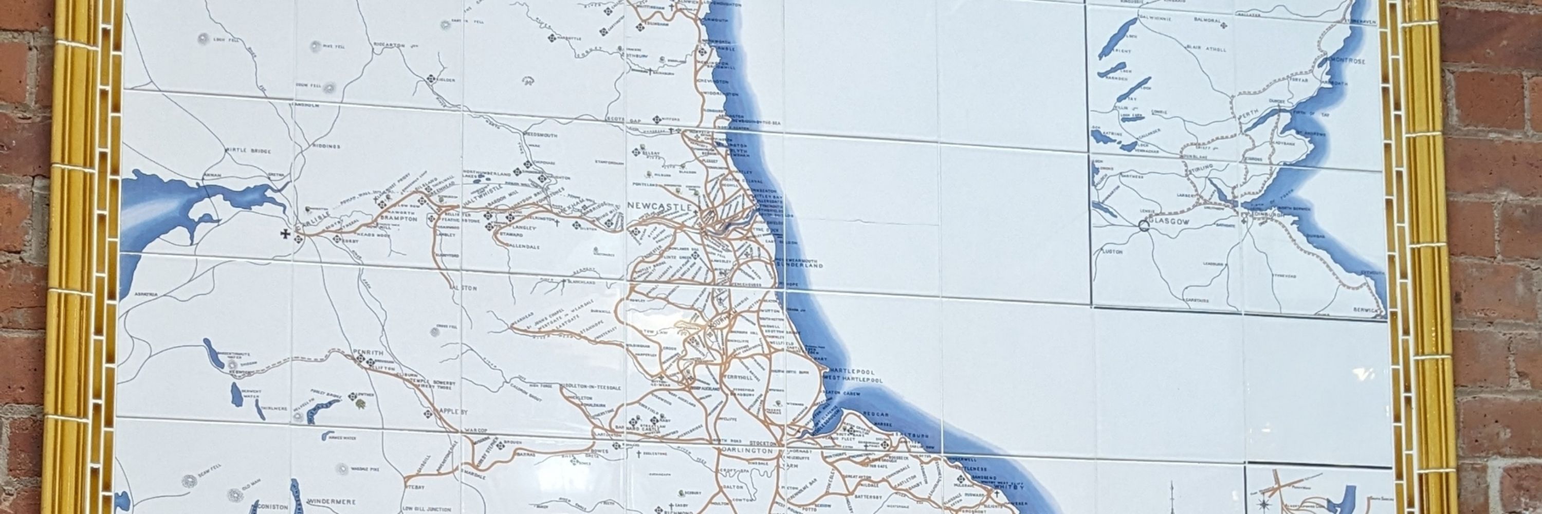
Just spotted this new map at #Charlbury station. Congrats to @oxcrp.bsky.social and @gwr.com for some eye catching cartography. @bcsmaps.bsky.social @openstreetmap.bsky.social

January 21, 2026 at 9:28 AM
Just spotted this new map at #Charlbury station. Congrats to @oxcrp.bsky.social and @gwr.com for some eye catching cartography. @bcsmaps.bsky.social @openstreetmap.bsky.social
Brilliant!

"Who is the man who appears unexpectedly in an OS map..?"

January 9, 2026 at 10:02 PM
Brilliant!
Reposted by Nick Millea

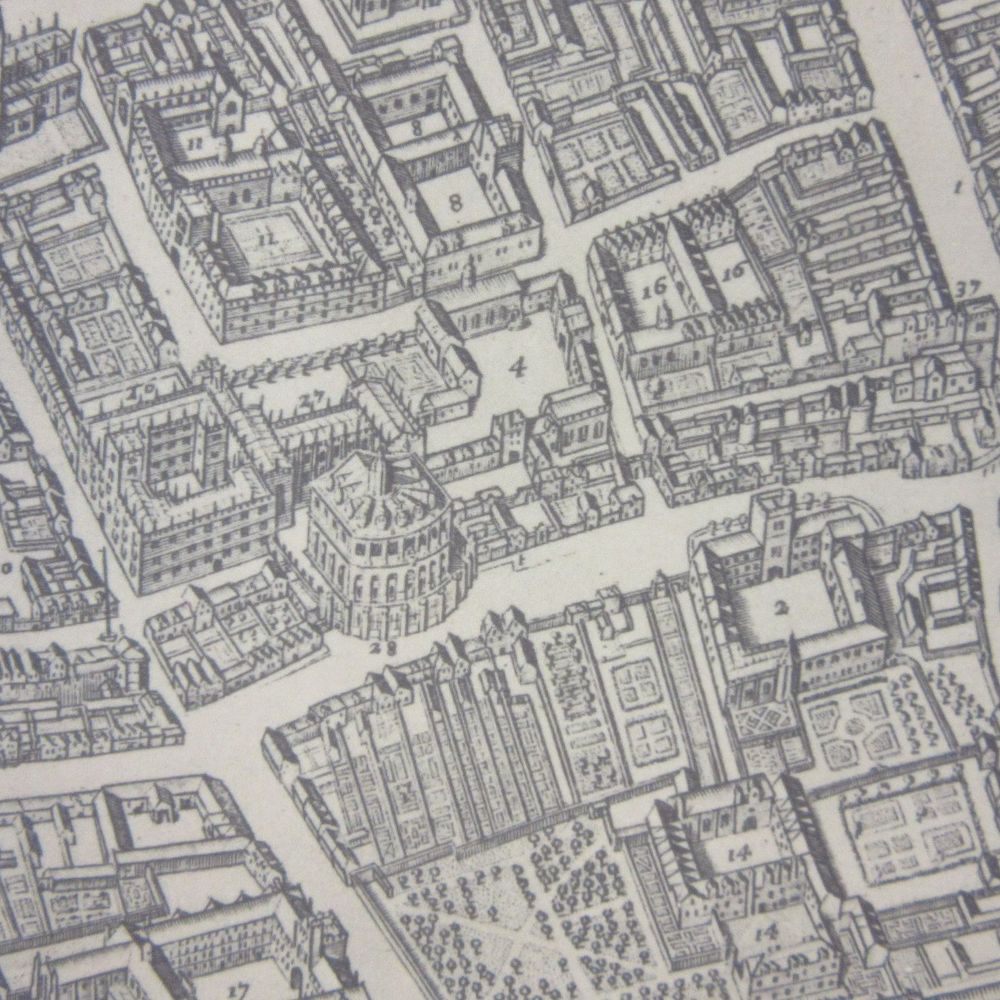
A map of the University and city from 1751, much of it still recognisable today! 🗺️
Shelmark: Bodleian Library, Gough Maps Oxfordshire 12
Shelmark: Bodleian Library, Gough Maps Oxfordshire 12

January 9, 2026 at 3:40 PM
A map of the University and city from 1751, much of it still recognisable today! 🗺️
Shelmark: Bodleian Library, Gough Maps Oxfordshire 12
Shelmark: Bodleian Library, Gough Maps Oxfordshire 12
Reposted by Nick Millea
Reindeer appear in more places than you might expect... including maps!
These festive friends are watching mapmakers at work, decorating historic landscapes as well as popping up in modern tourist and children’s maps.🎄
Read more: https://blogs.bodleian.ox.ac.uk/maps/2024/12/18/looks-like-reindeer/
These festive friends are watching mapmakers at work, decorating historic landscapes as well as popping up in modern tourist and children’s maps.🎄
Read more: https://blogs.bodleian.ox.ac.uk/maps/2024/12/18/looks-like-reindeer/


December 23, 2025 at 3:48 PM
Reindeer appear in more places than you might expect... including maps!
These festive friends are watching mapmakers at work, decorating historic landscapes as well as popping up in modern tourist and children’s maps.🎄
Read more: https://blogs.bodleian.ox.ac.uk/maps/2024/12/18/looks-like-reindeer/
These festive friends are watching mapmakers at work, decorating historic landscapes as well as popping up in modern tourist and children’s maps.🎄
Read more: https://blogs.bodleian.ox.ac.uk/maps/2024/12/18/looks-like-reindeer/
Reposted by Nick Millea
Big thanks to The Scarborough News for their article on our upcoming historical map of Scarborough.
If you'd like to donate to the project, you can do so here: shop.historictownstrust.uk/product/donate
If you'd like to donate to the project, you can do so here: shop.historictownstrust.uk/product/donate

December 24, 2025 at 12:14 AM
Big thanks to The Scarborough News for their article on our upcoming historical map of Scarborough.
If you'd like to donate to the project, you can do so here: shop.historictownstrust.uk/product/donate
If you'd like to donate to the project, you can do so here: shop.historictownstrust.uk/product/donate
Reposted by Nick Millea

cycle.travel now has a fresh new look on iPhone and Android – clearer, easier to use, and with new features such as clickable route highlights. Take a look on your app store of choice!
iPhone: apps.apple.com/app/id161963...
Android: play.google.com/store/apps/d...
iPhone: apps.apple.com/app/id161963...
Android: play.google.com/store/apps/d...


December 24, 2025 at 1:28 PM
cycle.travel now has a fresh new look on iPhone and Android – clearer, easier to use, and with new features such as clickable route highlights. Take a look on your app store of choice!
iPhone: apps.apple.com/app/id161963...
Android: play.google.com/store/apps/d...
iPhone: apps.apple.com/app/id161963...
Android: play.google.com/store/apps/d...
Reposted by Nick Millea
Today marks the #WinterSolstice ❄️
This illustrated page, ‘Erde und Sonne’, from a German atlas by Justus Perthes (c.1910), shows how Earth’s tilt and orbit create the solstices, equinoxes and seasons.
📜 | Bodleian Map Room Blog
More at: https://blogs.bodleian.ox.ac.uk/maps/2024/03/19/spring/
This illustrated page, ‘Erde und Sonne’, from a German atlas by Justus Perthes (c.1910), shows how Earth’s tilt and orbit create the solstices, equinoxes and seasons.
📜 | Bodleian Map Room Blog
More at: https://blogs.bodleian.ox.ac.uk/maps/2024/03/19/spring/


December 21, 2025 at 5:44 PM
Today marks the #WinterSolstice ❄️
This illustrated page, ‘Erde und Sonne’, from a German atlas by Justus Perthes (c.1910), shows how Earth’s tilt and orbit create the solstices, equinoxes and seasons.
📜 | Bodleian Map Room Blog
More at: https://blogs.bodleian.ox.ac.uk/maps/2024/03/19/spring/
This illustrated page, ‘Erde und Sonne’, from a German atlas by Justus Perthes (c.1910), shows how Earth’s tilt and orbit create the solstices, equinoxes and seasons.
📜 | Bodleian Map Room Blog
More at: https://blogs.bodleian.ox.ac.uk/maps/2024/03/19/spring/
Reposted by Nick Millea

Delighted to be continuing as a research assistant on the London on the Eve of the Great Fire project. To support the creation of this Atlas and Gazetteer of 1665-6 London then consider a donation to the project. @historictownstrust.bsky.social 🗃️ shop.historictownstrust.uk/product/donate


December 20, 2025 at 1:24 PM
Delighted to be continuing as a research assistant on the London on the Eve of the Great Fire project. To support the creation of this Atlas and Gazetteer of 1665-6 London then consider a donation to the project. @historictownstrust.bsky.social 🗃️ shop.historictownstrust.uk/product/donate
Our next @bodleian.ox.ac.uk #Maps blog takes us to a wintry C18 #Norway with @debbietheduck.bsky.social. JB Homann's map of #Akershus also takes us underground. Explore detailed mine workings nearby modern #Oslo.
blogs.bodleian.ox.ac.uk/maps/2025/12... @bcsmaps.bsky.social @imagomundi.bsky.social
blogs.bodleian.ox.ac.uk/maps/2025/12... @bcsmaps.bsky.social @imagomundi.bsky.social


December 15, 2025 at 4:10 PM
Our next @bodleian.ox.ac.uk #Maps blog takes us to a wintry C18 #Norway with @debbietheduck.bsky.social. JB Homann's map of #Akershus also takes us underground. Explore detailed mine workings nearby modern #Oslo.
blogs.bodleian.ox.ac.uk/maps/2025/12... @bcsmaps.bsky.social @imagomundi.bsky.social
blogs.bodleian.ox.ac.uk/maps/2025/12... @bcsmaps.bsky.social @imagomundi.bsky.social
Reposted by Nick Millea
Today is International Mountain Day. Here are covers for Snowdon (1,085 metres), for a Soviet map of the Teberda region of the Caucasus mountains (over 4000 m in places) and of the Zermatt region of Switzerland with the Matterhorn, 4,478 m, on the cover. Happy climbing everyone. @bodleian.ox.ac.uk


December 11, 2025 at 9:37 AM
Today is International Mountain Day. Here are covers for Snowdon (1,085 metres), for a Soviet map of the Teberda region of the Caucasus mountains (over 4000 m in places) and of the Zermatt region of Switzerland with the Matterhorn, 4,478 m, on the cover. Happy climbing everyone. @bodleian.ox.ac.uk
Reposted by Nick Millea

Thank you to Caroline Gomm from HarperCollins who presented the Collins Bartholomew award, and to Jim Goldsmith, BCS Awards officer, who presented the Stanfords award.
Our BCS President Paul Naylor then presented the overall “Best of the Best” BCS Award to the recipients.
Our BCS President Paul Naylor then presented the overall “Best of the Best” BCS Award to the recipients.


December 5, 2025 at 4:07 PM
Thank you to Caroline Gomm from HarperCollins who presented the Collins Bartholomew award, and to Jim Goldsmith, BCS Awards officer, who presented the Stanfords award.
Our BCS President Paul Naylor then presented the overall “Best of the Best” BCS Award to the recipients.
Our BCS President Paul Naylor then presented the overall “Best of the Best” BCS Award to the recipients.
@bodleian.ox.ac.uk #Maps team delighted to host our friends from @bcsmaps.bsky.social & @ordnancesurvey.bsky.social today. Should be a great afternoon. @stanfordstravel.bsky.social @harpercollins.bsky.social
Behind the scenes at the BCS Awards in Person Presentation at the Bodleian library for Stanfords, Collins Bartholomew, and the overall BCS Award. Winning entry is the Atlas of Finance! Congratulations to all involved


December 5, 2025 at 2:02 PM
@bodleian.ox.ac.uk #Maps team delighted to host our friends from @bcsmaps.bsky.social & @ordnancesurvey.bsky.social today. Should be a great afternoon. @stanfordstravel.bsky.social @harpercollins.bsky.social
Reposted by Nick Millea

Deadline approaching for the ISHMap Prize for Projects in Map History.
In 2024 or 2025, did you participate in a neat map history project that wasn't a book or an article? Submit it for a shiny prize!!
Nominations due 31 Dec 2025.
#maps #maphistory #skystorians #GIS 🗃️
In 2024 or 2025, did you participate in a neat map history project that wasn't a book or an article? Submit it for a shiny prize!!
Nominations due 31 Dec 2025.
#maps #maphistory #skystorians #GIS 🗃️

Prize for Projects in Map History 2026
The International Society for the History of the Map (ISHMap) is pleased to invite nominations and self-nominations for its Prize for Projects in Map History. The ISHMap Prize in for Pr…
ishmap.com
December 2, 2025 at 12:45 PM
Deadline approaching for the ISHMap Prize for Projects in Map History.
In 2024 or 2025, did you participate in a neat map history project that wasn't a book or an article? Submit it for a shiny prize!!
Nominations due 31 Dec 2025.
#maps #maphistory #skystorians #GIS 🗃️
In 2024 or 2025, did you participate in a neat map history project that wasn't a book or an article? Submit it for a shiny prize!!
Nominations due 31 Dec 2025.
#maps #maphistory #skystorians #GIS 🗃️
Reposted by Nick Millea
A grim 'X marks the spot'. Wilson is Major Allan Wilson, who led a small unit of British South African soldiers in the 1st Matabele War. On the 3rd and 4th of December 1893 they came up against a much larger force of Matabele warriors along the Shangani River, in modern Zimbabwe. @bodleian.ox.ac.uk

December 2, 2025 at 9:39 AM
A grim 'X marks the spot'. Wilson is Major Allan Wilson, who led a small unit of British South African soldiers in the 1st Matabele War. On the 3rd and 4th of December 1893 they came up against a much larger force of Matabele warriors along the Shangani River, in modern Zimbabwe. @bodleian.ox.ac.uk
Reposted by Nick Millea
Impressive new official UK online railway map. Appears to be vector tiles, Maplibre JS, manual selection of stations for each zoom level, hints for label placement baked into the tiles. No authorship information that I can see, but someone deserves plaudits for this. railmap.nationalrail.co.uk
An interactive and zoomable version of the entire National Rail network in Great Britain. Showing all lines, all stations and all Train Company routes.
railmap.nationalrail.co.uk
November 30, 2025 at 12:39 PM
Impressive new official UK online railway map. Appears to be vector tiles, Maplibre JS, manual selection of stations for each zoom level, hints for label placement baked into the tiles. No authorship information that I can see, but someone deserves plaudits for this. railmap.nationalrail.co.uk
Reposted by Nick Millea
Here's an interesting variation on D.I.Y. From a map of Europe at the start of the War, 1914, an invitation from the Financial Times to fill in boundaries based on predicted peace terms. Offered at a time when 'it will be all over by Christmas' I wonder if anyone got even close? @bodleian.ox.ac.uk

November 28, 2025 at 10:11 AM
Here's an interesting variation on D.I.Y. From a map of Europe at the start of the War, 1914, an invitation from the Financial Times to fill in boundaries based on predicted peace terms. Offered at a time when 'it will be all over by Christmas' I wonder if anyone got even close? @bodleian.ox.ac.uk
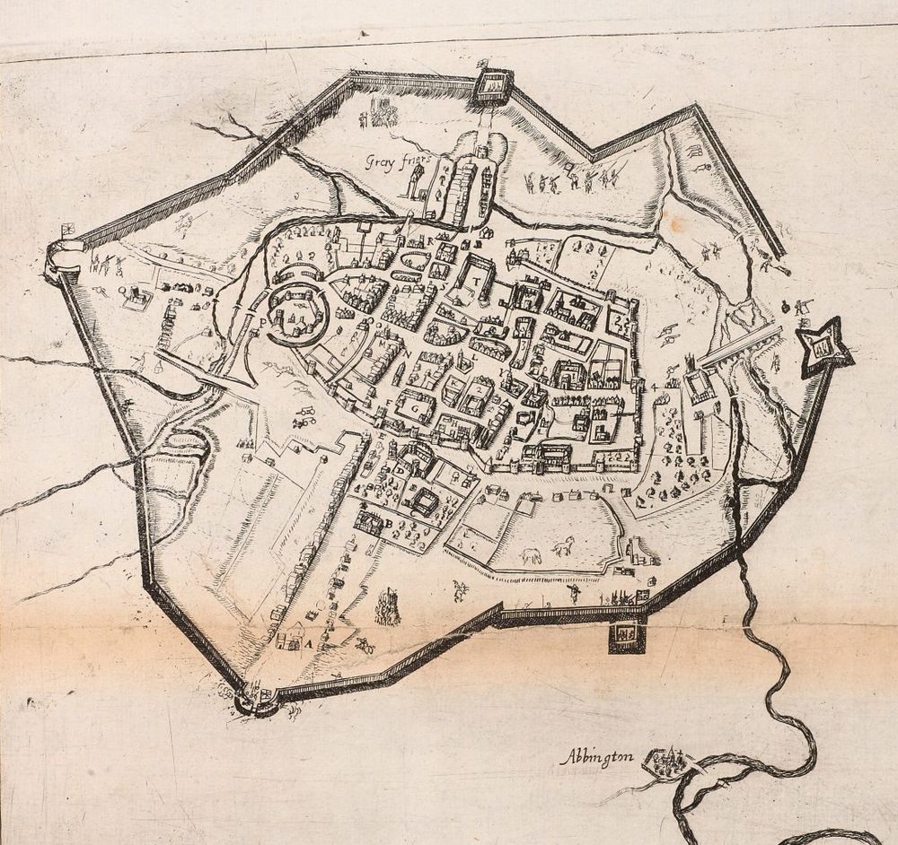
Our next @bodleian.ox.ac.uk #maps blog by @stuartackland.bsky.social features the "false" map of #Oxford from 1644. Look at this and be prepared to be confused!
blogs.bodleian.ox.ac.uk/maps/. When is north not north? And who was Anthony Wood? @bcsmaps.bsky.social @ox.ac.uk @bbcoxford.bsky.social
blogs.bodleian.ox.ac.uk/maps/. When is north not north? And who was Anthony Wood? @bcsmaps.bsky.social @ox.ac.uk @bbcoxford.bsky.social


November 26, 2025 at 12:14 PM
Our next @bodleian.ox.ac.uk #maps blog by @stuartackland.bsky.social features the "false" map of #Oxford from 1644. Look at this and be prepared to be confused!
blogs.bodleian.ox.ac.uk/maps/. When is north not north? And who was Anthony Wood? @bcsmaps.bsky.social @ox.ac.uk @bbcoxford.bsky.social
blogs.bodleian.ox.ac.uk/maps/. When is north not north? And who was Anthony Wood? @bcsmaps.bsky.social @ox.ac.uk @bbcoxford.bsky.social
Reposted by Nick Millea
RIP Jimmy Cliff, musical titan, reggae giant, who also wrote and sang this, the unofficial anthem to audax cycling. For me it has to be the rarer, R&B arrangement. @audaxuk.bsky.social www.youtube.com/watch?v=_2zs...

Jimmy Cliff - Hard Road To Travel - Federal Records RARE Soul version
YouTube video by Kingstoned - soundzz
www.youtube.com
November 24, 2025 at 2:07 PM
RIP Jimmy Cliff, musical titan, reggae giant, who also wrote and sang this, the unofficial anthem to audax cycling. For me it has to be the rarer, R&B arrangement. @audaxuk.bsky.social www.youtube.com/watch?v=_2zs...
Thursday at 16:30 (UK time) - our 1st online #TOSCA of 25/26: @drpragyaagarwal.bsky.social on 'Mapping sense of place: Travels and Maps of May Morris'. Book your place at: www.bodleian.ox.ac.uk/maps/tosca. @bodleian.ox.ac.uk @oxfordgeography.bsky.social @bcsmaps.bsky.social @imagomundi.bsky.social

November 25, 2025 at 11:24 AM
Thursday at 16:30 (UK time) - our 1st online #TOSCA of 25/26: @drpragyaagarwal.bsky.social on 'Mapping sense of place: Travels and Maps of May Morris'. Book your place at: www.bodleian.ox.ac.uk/maps/tosca. @bodleian.ox.ac.uk @oxfordgeography.bsky.social @bcsmaps.bsky.social @imagomundi.bsky.social
Reposted by Nick Millea
👀🙌 "6,652 maps associated with the Second Land Utilisation Survey of Great Britain (ca. 1958-1974)... primarily 1:10,560 National Grid sheets, were hand annotated with different colours, shadings and abbreviations to indicate land use, such as arable, settlement, industrial, grassland or woodland."

This #MapMonday we celebrate an amazing crowd-sourced project, the Second Land Utilisation Survey of Great Britain.
Directed by Professor Alice Coleman, the project involved over 3,000 volunteers, including university students and schoolchildren.
Explore the maps > maps.nls.uk/additions/#189
Directed by Professor Alice Coleman, the project involved over 3,000 volunteers, including university students and schoolchildren.
Explore the maps > maps.nls.uk/additions/#189

November 24, 2025 at 12:52 PM
👀🙌 "6,652 maps associated with the Second Land Utilisation Survey of Great Britain (ca. 1958-1974)... primarily 1:10,560 National Grid sheets, were hand annotated with different colours, shadings and abbreviations to indicate land use, such as arable, settlement, industrial, grassland or woodland."
Reposted by Nick Millea
Our article on #Mapathon 1571 is now online at the Leventhal Map & Education Center!
👉 www.leventhalmap.org/articles/map...
This publication was made possible through the Allmaps Research Fellowships.
Thanks to my co-authors at #GhentCDH and #Allmaps, and @bplmaps.bsky.social for the support.
👉 www.leventhalmap.org/articles/map...
This publication was made possible through the Allmaps Research Fellowships.
Thanks to my co-authors at #GhentCDH and #Allmaps, and @bplmaps.bsky.social for the support.

Mapathon 1571: Building Community Cartography Through Collective Georeferencing - Leventhal Map & Education Center at the Boston Public Library
How a sixteenth-century map reconnects contemporary audiences with its historical landscape
www.leventhalmap.org
November 17, 2025 at 8:17 AM
Our article on #Mapathon 1571 is now online at the Leventhal Map & Education Center!
👉 www.leventhalmap.org/articles/map...
This publication was made possible through the Allmaps Research Fellowships.
Thanks to my co-authors at #GhentCDH and #Allmaps, and @bplmaps.bsky.social for the support.
👉 www.leventhalmap.org/articles/map...
This publication was made possible through the Allmaps Research Fellowships.
Thanks to my co-authors at #GhentCDH and #Allmaps, and @bplmaps.bsky.social for the support.