


Laura Gerrish
@lauragerrish.bsky.social
GIS and Mapping Specialist at the British Antarctic Survey. Interested in cartography, data visualisation, remote sensing and glaciology ❄️
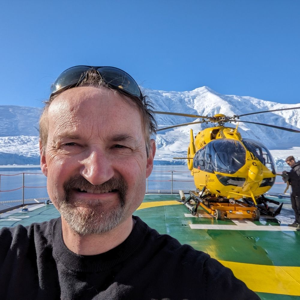
This was one of my last things to organise at work before soon going on maternity leave and it's always so nice to see how much people still love paper maps. There's just something special about them and the joy, conversation and memories that they bring about 🥰
We ran a Map Giveaway for BAS staff & students this week, raising money for @mapaction.bsky.social! The maps were a mixture of beautiful, historical maps from the 70s and 80s, and previous versions of our main published maps. We had so much interest - thanks BAS for the support & generous donations!


October 31, 2025 at 2:17 PM
This was one of my last things to organise at work before soon going on maternity leave and it's always so nice to see how much people still love paper maps. There's just something special about them and the joy, conversation and memories that they bring about 🥰
Reposted by Laura Gerrish
We are so pleased to announce the official launch of the new BAS Map Catalogue 🎉🗺
The catalogue contains open access topographic, thematic and geological maps, as well as full details on where to purchase our professionally printed published maps.
Have a look for yourselves at bas.ac.uk/maps!
1/2
The catalogue contains open access topographic, thematic and geological maps, as well as full details on where to purchase our professionally printed published maps.
Have a look for yourselves at bas.ac.uk/maps!
1/2
🗺️NEW: BAS Map Catalogue is live!
Explore Antarctica and the Arctic through our collection of professional maps. Perfect for educators, adventurers, and polar enthusiasts. Many available on open licence for free download. #PolarMaps #Antarctica
Explore Antarctica and the Arctic through our collection of professional maps. Perfect for educators, adventurers, and polar enthusiasts. Many available on open licence for free download. #PolarMaps #Antarctica
September 19, 2025 at 9:12 AM
We are so pleased to announce the official launch of the new BAS Map Catalogue 🎉🗺
The catalogue contains open access topographic, thematic and geological maps, as well as full details on where to purchase our professionally printed published maps.
Have a look for yourselves at bas.ac.uk/maps!
1/2
The catalogue contains open access topographic, thematic and geological maps, as well as full details on where to purchase our professionally printed published maps.
Have a look for yourselves at bas.ac.uk/maps!
1/2
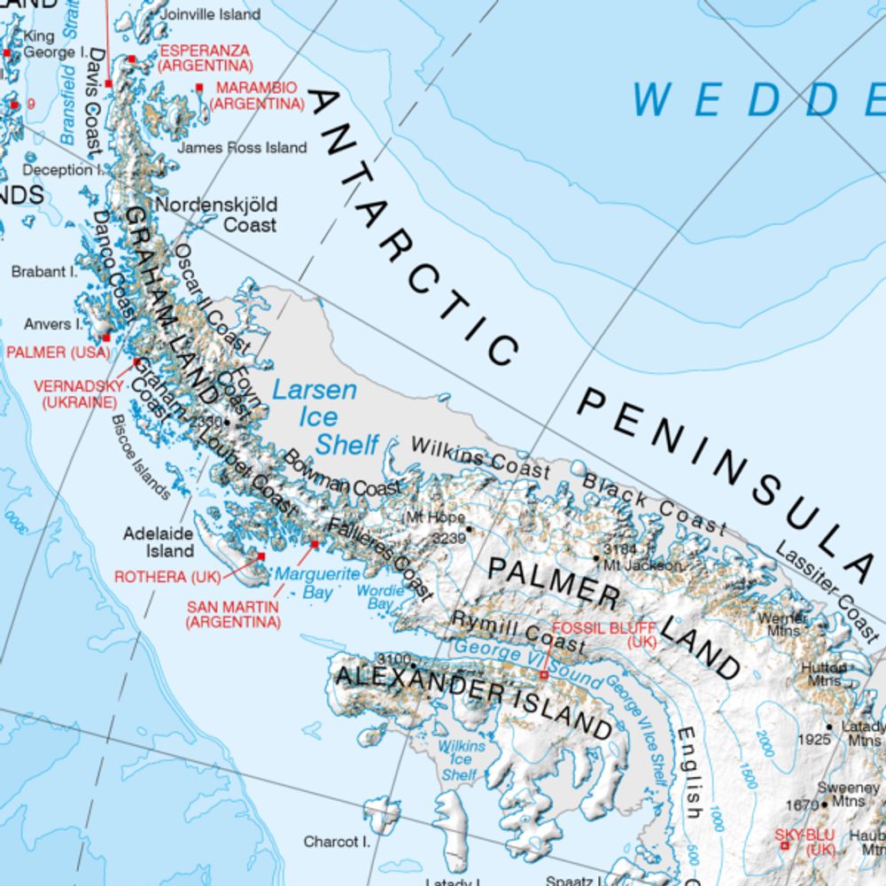
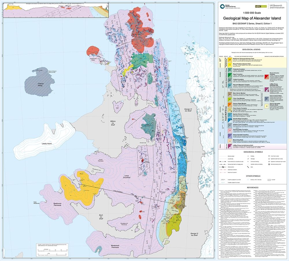
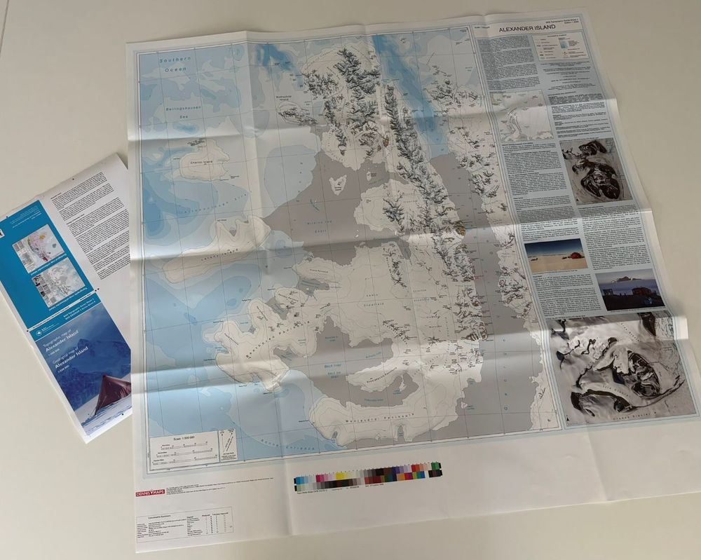
Thank you so much to the British Cartographic Society for recognising 2 of @bas.ac.uk’s maps at last week’s conference. It was fantastic to collect the certificate for our recently-released Alexander Island map, one of the most interesting maps I’ve made in a long time!

Thank you to Stanfords Travel for their support in sponsoring the best paper map award 2025.
Congratulations to the four Highly Commended runners up in this category: British Antarctic Survey, Laura Gerrish (BAS), Kon-Tiki Maps, and Harvey Map Services.
Congratulations to the four Highly Commended runners up in this category: British Antarctic Survey, Laura Gerrish (BAS), Kon-Tiki Maps, and Harvey Map Services.


September 12, 2025 at 7:44 PM
Thank you so much to the British Cartographic Society for recognising 2 of @bas.ac.uk’s maps at last week’s conference. It was fantastic to collect the certificate for our recently-released Alexander Island map, one of the most interesting maps I’ve made in a long time!
#A23a iceberg continues its disintegration north of South Georgia in the South Atlantic, with a brilliant image from today finishing off this timelapse of Copernicus Sentinel-3 imagery over the last few weeks! It's always interesting to track these bergs out of Antarctica and into warmer waters 🌊🌴
September 11, 2025 at 8:14 PM
#A23a iceberg continues its disintegration north of South Georgia in the South Atlantic, with a brilliant image from today finishing off this timelapse of Copernicus Sentinel-3 imagery over the last few weeks! It's always interesting to track these bergs out of Antarctica and into warmer waters 🌊🌴
Reposted by Laura Gerrish
Iceberg A23A is currently located north of South Georgia & over the weekend has fragmented into a several large pieces. While these individual icebergs are large & may get new names, they may be short lived as further breakup is now likely as currents push them all further north into warmer waters.

September 2, 2025 at 9:55 AM
Iceberg A23A is currently located north of South Georgia & over the weekend has fragmented into a several large pieces. While these individual icebergs are large & may get new names, they may be short lived as further breakup is now likely as currents push them all further north into warmer waters.
Really looking forward to this conference at @bgs.ac.uk next week! Always great to catch up with other mapping enthusiasts. Is anyone else on here going to 1 or both days?
Thank you to these speakers who you can meet next week at BCS Annual Conference, 3-4 Sept, BGS, Keyworth, Nottingham
For more details see the BCS website lnkd.in/eCQrMjR where you can download full programme details. Link in bio 🔗
#mapping #community #excellence
#conference #network #awards
For more details see the BCS website lnkd.in/eCQrMjR where you can download full programme details. Link in bio 🔗
#mapping #community #excellence
#conference #network #awards

August 27, 2025 at 9:37 PM
Really looking forward to this conference at @bgs.ac.uk next week! Always great to catch up with other mapping enthusiasts. Is anyone else on here going to 1 or both days?
I'm just starting an update of BAS's published "Adelaide Island and Arrowsmith Peninsula" map. One of the first things I always work on is creating new hillshades & contours from the latest elevation data. These in-progress images show some of the interesting islands & landscapes in the region! 🏔️🧊


August 19, 2025 at 3:49 PM
I'm just starting an update of BAS's published "Adelaide Island and Arrowsmith Peninsula" map. One of the first things I always work on is creating new hillshades & contours from the latest elevation data. These in-progress images show some of the interesting islands & landscapes in the region! 🏔️🧊
This new topographic map has been my big project for the last few months and I'm so pleased to see it finally printed and published! 🗺️
It's been a truly fascinating region to work in, with changes happening almost before my eyes as I attempted to keep the new data up to date. ❄️🧊
It's been a truly fascinating region to work in, with changes happening almost before my eyes as I attempted to keep the new data up to date. ❄️🧊
📢 New Map Alert 🗺️
We have produced new maps of Alexander Island, along with the geology team here at @bas.ac.uk! These 1:500 000 scale maps cover the second largest uninhabited island in the world at a level of detail never before seen. See the full story here: www.bas.ac.uk/media-post/t...
1/2
We have produced new maps of Alexander Island, along with the geology team here at @bas.ac.uk! These 1:500 000 scale maps cover the second largest uninhabited island in the world at a level of detail never before seen. See the full story here: www.bas.ac.uk/media-post/t...
1/2

August 5, 2025 at 4:02 PM
This new topographic map has been my big project for the last few months and I'm so pleased to see it finally printed and published! 🗺️
It's been a truly fascinating region to work in, with changes happening almost before my eyes as I attempted to keep the new data up to date. ❄️🧊
It's been a truly fascinating region to work in, with changes happening almost before my eyes as I attempted to keep the new data up to date. ❄️🧊
Reposted by Laura Gerrish

NOAA has released their official animation of the propagation of this week's tsunami. It took almost exactly one day to reach Antarctica and was reported at 0.6 feet high.
July 31, 2025 at 4:29 PM
NOAA has released their official animation of the propagation of this week's tsunami. It took almost exactly one day to reach Antarctica and was reported at 0.6 feet high.
Reposted by Laura Gerrish
Bedmap3 map PDFs are now available to freely download from BAS
data.bas.ac.uk/items/757872...
data.bas.ac.uk/items/757872...
July 15, 2025 at 4:02 PM
Bedmap3 map PDFs are now available to freely download from BAS
data.bas.ac.uk/items/757872...
data.bas.ac.uk/items/757872...
South Georgia in winter 😍
These SAR and optical images show the island of South Georgia in the South Atlantic. SAR imagery allows us to see these locations through winter and cloud-covered days, and then the optical imagery adds extra content when it's not cloudy or dark!
These SAR and optical images show the island of South Georgia in the South Atlantic. SAR imagery allows us to see these locations through winter and cloud-covered days, and then the optical imagery adds extra content when it's not cloudy or dark!


July 11, 2025 at 10:02 AM
South Georgia in winter 😍
These SAR and optical images show the island of South Georgia in the South Atlantic. SAR imagery allows us to see these locations through winter and cloud-covered days, and then the optical imagery adds extra content when it's not cloudy or dark!
These SAR and optical images show the island of South Georgia in the South Atlantic. SAR imagery allows us to see these locations through winter and cloud-covered days, and then the optical imagery adds extra content when it's not cloudy or dark!
Reposted by Laura Gerrish
In case you were wondering... Iceberg A23a seen cruising around South Georgia today by Meteosat 12. The old berg still has an area of 2,846 sq km.

July 7, 2025 at 3:43 PM
In case you were wondering... Iceberg A23a seen cruising around South Georgia today by Meteosat 12. The old berg still has an area of 2,846 sq km.
📢 We're hiring! My team is currently advertising for my maternity cover for 12 months.
Join us, making maps and working on some of the most interesting aspects of my role. You'll get to work in beautiful Cambridge and meet all kinds of interesting people at the British Antarctic Survey ❄️🗺️
Join us, making maps and working on some of the most interesting aspects of my role. You'll get to work in beautiful Cambridge and meet all kinds of interesting people at the British Antarctic Survey ❄️🗺️
We're hiring a GIS and Mapping Specialist to manage our Geospatial Helpdesk and to contribute to our Topographic Map Series.
This is a really exciting opportunity at the British Antarctic Survey to support colleagues across the organisation. Details here: shorturl.at/bA4fd #GISjobs
This is a really exciting opportunity at the British Antarctic Survey to support colleagues across the organisation. Details here: shorturl.at/bA4fd #GISjobs
June 25, 2025 at 9:11 AM
📢 We're hiring! My team is currently advertising for my maternity cover for 12 months.
Join us, making maps and working on some of the most interesting aspects of my role. You'll get to work in beautiful Cambridge and meet all kinds of interesting people at the British Antarctic Survey ❄️🗺️
Join us, making maps and working on some of the most interesting aspects of my role. You'll get to work in beautiful Cambridge and meet all kinds of interesting people at the British Antarctic Survey ❄️🗺️
Reposted by Laura Gerrish
We've just received the proofs of our new Alexander Island map from Dennis Maps printers and have given the go ahead for printing!
This is the first comprehensive map of the entire region produced in decades. At 1:500 000 scale, it also features a geological map on the reverse 😍 Watch this space!
This is the first comprehensive map of the entire region produced in decades. At 1:500 000 scale, it also features a geological map on the reverse 😍 Watch this space!
June 19, 2025 at 2:04 PM
We've just received the proofs of our new Alexander Island map from Dennis Maps printers and have given the go ahead for printing!
This is the first comprehensive map of the entire region produced in decades. At 1:500 000 scale, it also features a geological map on the reverse 😍 Watch this space!
This is the first comprehensive map of the entire region produced in decades. At 1:500 000 scale, it also features a geological map on the reverse 😍 Watch this space!
Reposted by Laura Gerrish
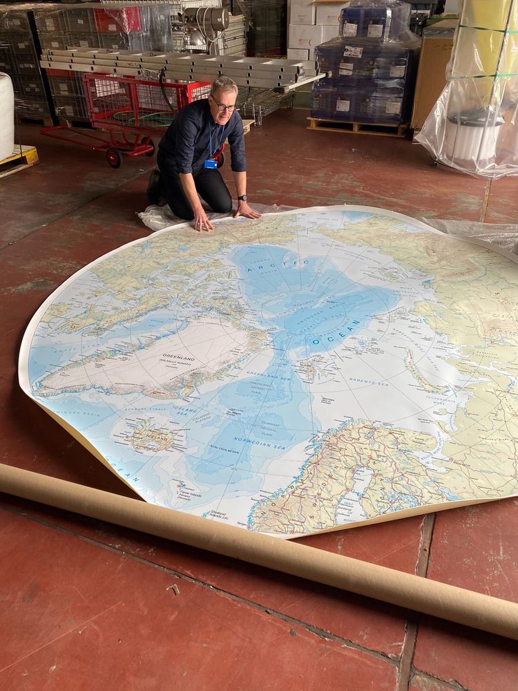
The NERC Arctic Office have printed a giant version of our main published Arctic map and it's come out beautifully! We can't wait to see this being used at upcoming events. Who doesn't want a huge 3 metre map?!

New map alert! Looking forward sharing at conferences and events before too long!
June 5, 2025 at 8:45 AM
The NERC Arctic Office have printed a giant version of our main published Arctic map and it's come out beautifully! We can't wait to see this being used at upcoming events. Who doesn't want a huge 3 metre map?!
Reposted by Laura Gerrish
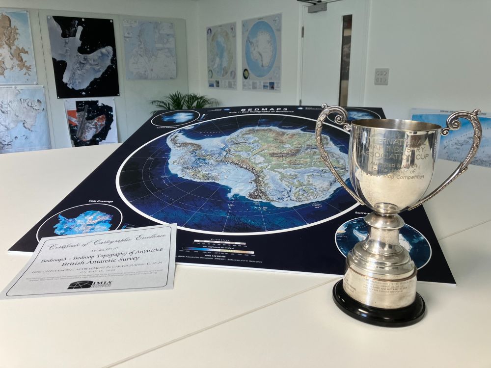
We're proud to share that our Bedmap3 map won "Best Map" at the International Map Industry Association (IMIA) forum in London last week! 🏆
This international award celebrates Outstanding Cartographic Design & we’re honoured to be recognised alongside leading names in the field from previous years. 🗺️
This international award celebrates Outstanding Cartographic Design & we’re honoured to be recognised alongside leading names in the field from previous years. 🗺️
May 21, 2025 at 3:21 PM
We're proud to share that our Bedmap3 map won "Best Map" at the International Map Industry Association (IMIA) forum in London last week! 🏆
This international award celebrates Outstanding Cartographic Design & we’re honoured to be recognised alongside leading names in the field from previous years. 🗺️
This international award celebrates Outstanding Cartographic Design & we’re honoured to be recognised alongside leading names in the field from previous years. 🗺️
I'm speaking at the IMIA Mapping Leaders Forum next week in London.
Is anyone here attending? I'm looking forward to meeting other mapping enthusiasts and experts at the 2 day event!
There are still a few spaces left if you'd like to come along. More details here: imiamaps.org/mapping-lead...
Is anyone here attending? I'm looking forward to meeting other mapping enthusiasts and experts at the 2 day event!
There are still a few spaces left if you'd like to come along. More details here: imiamaps.org/mapping-lead...

Mapping Leaders Forum - IMIA | International Map Industry Association
May 14-15, 2025 | The News Building, London
The IMIA Mapping Leader Forum brings together industry leaders, business experts, and technology innovators during this annual two-day event to explore the...
imiamaps.org
May 7, 2025 at 8:53 PM
I'm speaking at the IMIA Mapping Leaders Forum next week in London.
Is anyone here attending? I'm looking forward to meeting other mapping enthusiasts and experts at the 2 day event!
There are still a few spaces left if you'd like to come along. More details here: imiamaps.org/mapping-lead...
Is anyone here attending? I'm looking forward to meeting other mapping enthusiasts and experts at the 2 day event!
There are still a few spaces left if you'd like to come along. More details here: imiamaps.org/mapping-lead...
Reposted by Laura Gerrish

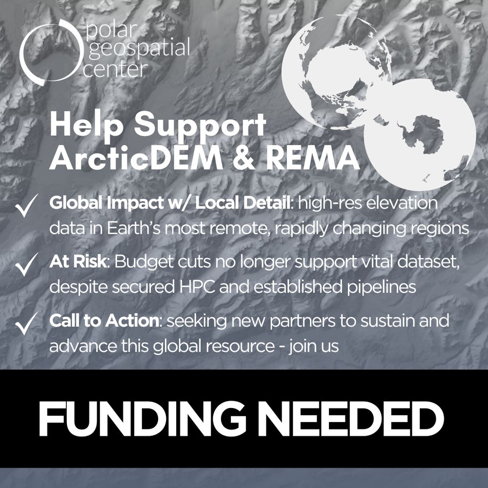
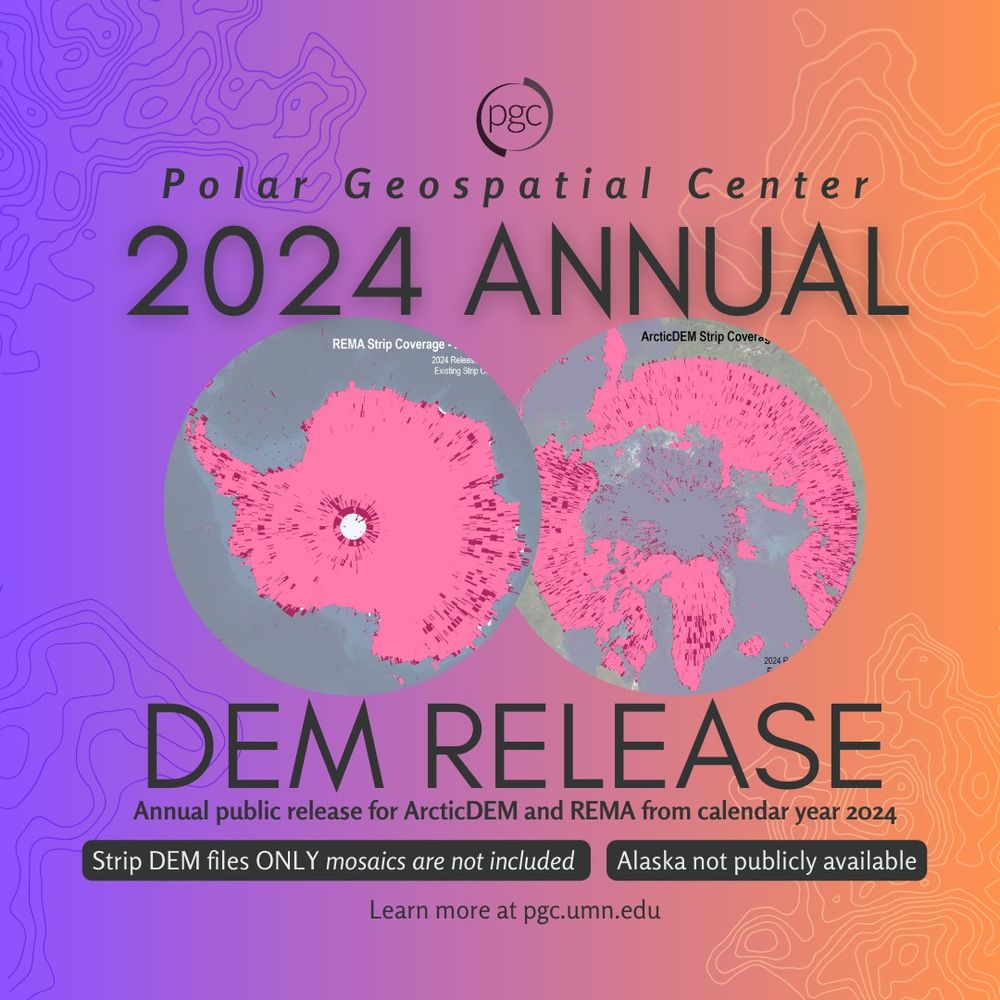
📢 The final ArcticDEM & REMA release is here - and it might be the last. Funding cuts put vital polar data at risk. Help us rally support: take the survey! 🔗https://z.umn.edu/pgc-dem-survey #PolarScience #SavePolarData
April 28, 2025 at 5:37 PM
📢 The final ArcticDEM & REMA release is here - and it might be the last. Funding cuts put vital polar data at risk. Help us rally support: take the survey! 🔗https://z.umn.edu/pgc-dem-survey #PolarScience #SavePolarData
Reposted by Laura Gerrish
Did you know that from 2000 to 2020, retreat of marine-terminating glaciers exposed >2,400 km of new Arctic coastline?
www.nature.com/articles/s41...
Congratulations, @mettebendixen.bsky.social, @cpecz.bsky.social, Jan Kavan, Matt Strelecki, and co., on your excellent paper!
www.nature.com/articles/s41...
Congratulations, @mettebendixen.bsky.social, @cpecz.bsky.social, Jan Kavan, Matt Strelecki, and co., on your excellent paper!

New coasts emerging from the retreat of Northern Hemisphere marine-terminating glaciers in the twenty-first century - Nature Climate Change
As marine-terminating glaciers retreat, they reveal new coastlines in many regions. Here the authors use satellite data to quantify these changes for the Northern Hemisphere, finding that between 2000...
www.nature.com
March 23, 2025 at 6:10 PM
Did you know that from 2000 to 2020, retreat of marine-terminating glaciers exposed >2,400 km of new Arctic coastline?
www.nature.com/articles/s41...
Congratulations, @mettebendixen.bsky.social, @cpecz.bsky.social, Jan Kavan, Matt Strelecki, and co., on your excellent paper!
www.nature.com/articles/s41...
Congratulations, @mettebendixen.bsky.social, @cpecz.bsky.social, Jan Kavan, Matt Strelecki, and co., on your excellent paper!
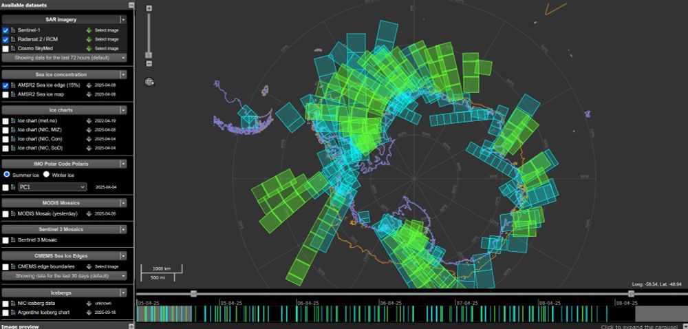
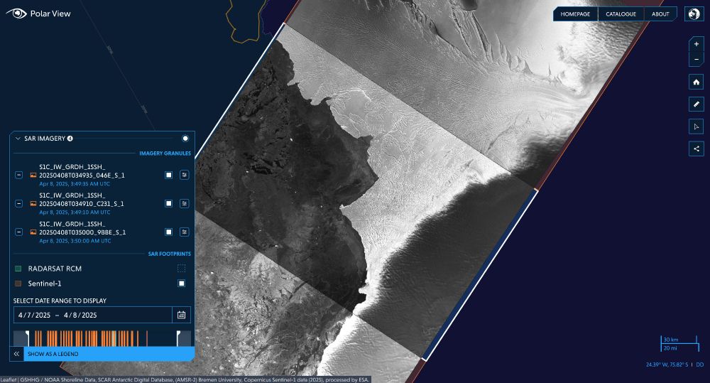
More data! 😄 I love looking at Sentinel-1 imagery through these portals because it gives a near-real-time insight into changes in Antarctica, and the detail in the sea ice patterns can be so insightful for a range of people working in the region 🚢 🛰️ 🌊
🎉 Imagery from the newly launched Sentinel-1C Copernicus satellite is now accessible via Polar View www.polarview.aq and the Ice Logistics Portal www.icelogistics.info/antarctic?ce...! This addition significantly increases the repeatability of SAR observations in the Polar Regions 🛰️
April 8, 2025 at 5:52 PM
More data! 😄 I love looking at Sentinel-1 imagery through these portals because it gives a near-real-time insight into changes in Antarctica, and the detail in the sea ice patterns can be so insightful for a range of people working in the region 🚢 🛰️ 🌊
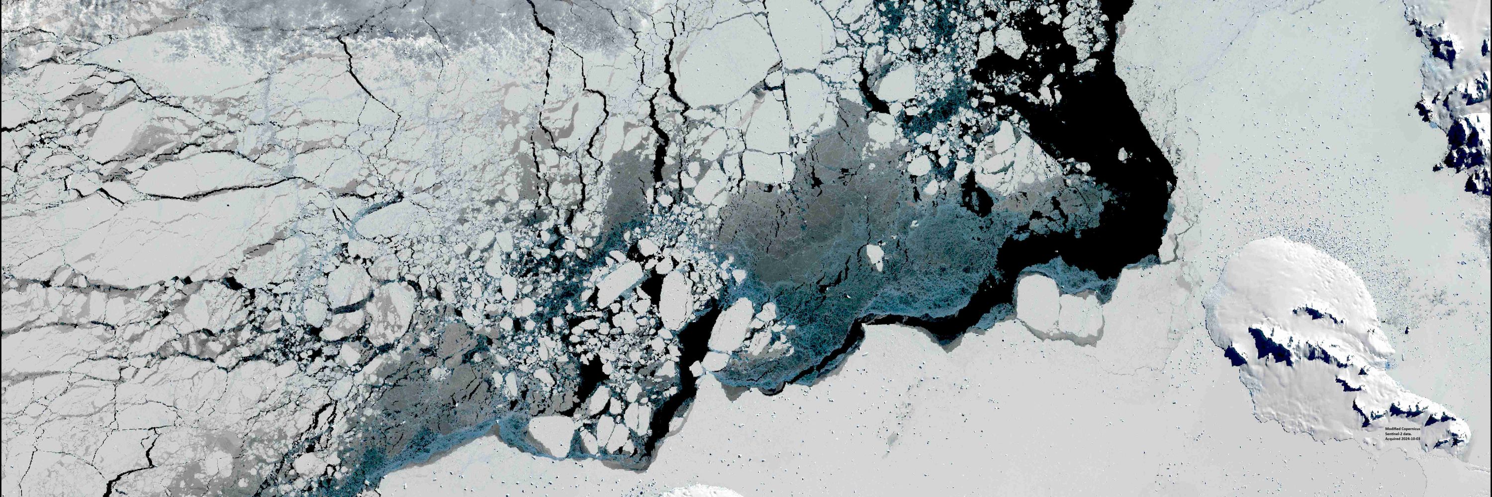
I've picked up my new Alexander Island map today after a month or two of other work, and while double checking some data, I noticed that this section of ice shelf has retreated by over 1.5 km in places since I updated the data in November. Can things just stop melting?! Keeps me busy for sure!

April 3, 2025 at 11:14 AM
I've picked up my new Alexander Island map today after a month or two of other work, and while double checking some data, I noticed that this section of ice shelf has retreated by over 1.5 km in places since I updated the data in November. Can things just stop melting?! Keeps me busy for sure!
Reposted by Laura Gerrish
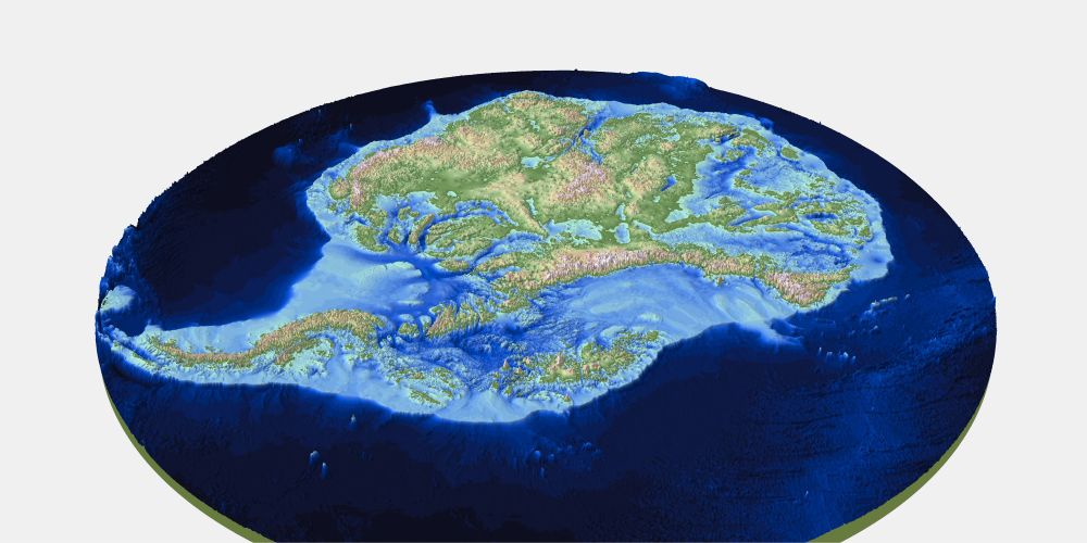
We’ve just published the most detailed map yet of the landscape beneath Antarctica’s ice sheet (called Bedmap3), and we learnt some pretty cool facts about Antarctica that you can use to impress your pals. Ready?
Graphic: Hamish Pritchard et al
Graphic: Hamish Pritchard et al
March 14, 2025 at 3:18 PM
We’ve just published the most detailed map yet of the landscape beneath Antarctica’s ice sheet (called Bedmap3), and we learnt some pretty cool facts about Antarctica that you can use to impress your pals. Ready?
Graphic: Hamish Pritchard et al
Graphic: Hamish Pritchard et al
Reposted by Laura Gerrish
We've been working with this beautiful Copernicus Sentinel-2 imagery this week, showing South Georgia in all its glory in Feb. 2018.
The sediment plumes are clearly highlighted here and it is extremely rare to get an almost cloud-free image of the whole island 🏔️😍
The sediment plumes are clearly highlighted here and it is extremely rare to get an almost cloud-free image of the whole island 🏔️😍


March 12, 2025 at 10:08 AM
We've been working with this beautiful Copernicus Sentinel-2 imagery this week, showing South Georgia in all its glory in Feb. 2018.
The sediment plumes are clearly highlighted here and it is extremely rare to get an almost cloud-free image of the whole island 🏔️😍
The sediment plumes are clearly highlighted here and it is extremely rare to get an almost cloud-free image of the whole island 🏔️😍
Lovely image from the NOAA-20 satellite yesterday showing the location of grounded A23a iceberg close to the island of South Georgia 😍
It's still crazy to me that this iceberg has been in the Southern Ocean since 1986, taking a few little pauses along its way to this current position!
@bas.ac.uk
It's still crazy to me that this iceberg has been in the Southern Ocean since 1986, taking a few little pauses along its way to this current position!
@bas.ac.uk


March 5, 2025 at 10:49 AM
Lovely image from the NOAA-20 satellite yesterday showing the location of grounded A23a iceberg close to the island of South Georgia 😍
It's still crazy to me that this iceberg has been in the Southern Ocean since 1986, taking a few little pauses along its way to this current position!
@bas.ac.uk
It's still crazy to me that this iceberg has been in the Southern Ocean since 1986, taking a few little pauses along its way to this current position!
@bas.ac.uk
Back to one of my favourite tasks of iceberg mapping 😄
The world's largest iceberg, A23a, appears to have grounded close to South Georgia. We've been monitoring and mapping this berg for many years now and we're watching closely to see what it might do next! These maps show its route since 1986 and the latest position to the SW of South Georgia ❄️🐧
1/3
1/3


March 4, 2025 at 2:14 PM
Back to one of my favourite tasks of iceberg mapping 😄