


Kenneth Wong
@kennethkhw.bsky.social
Urbanist, Map nerd, Hongkonger, GIS, #RStats
🔗 mappyurbanist.com
🔗 mappyurbanist.com
Pinned
Kenneth Wong
@kennethkhw.bsky.social
· Feb 24
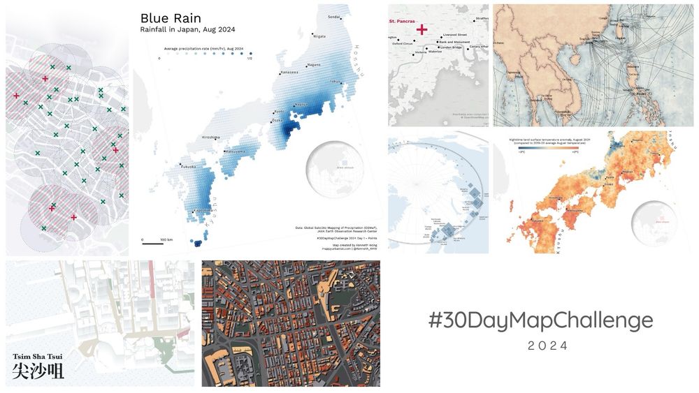
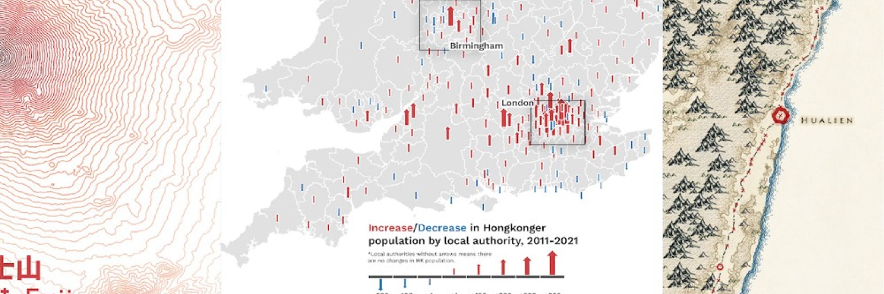
Postmortem of my #30DayMapChallenge 2024 | Kenneth Wong - Cities and Maps
Behind the scenes of making the maps
mappyurbanist.com
Finally closing my 2024 #30DayMapChallenge! Wrote a blog summarising what I learned, the behind-the-scenes challenges faced, and the fun I had creating maps last Nov.
Check the blog and maps out here:
🗺️🔗 mappyurbanist.com/blog/2025-02...
#gischat
Check the blog and maps out here:
🗺️🔗 mappyurbanist.com/blog/2025-02...
#gischat
Trying John Nelson's tutorial to generate a prefecture map of Japan in "classic National Geographic sort of political style". Having so much fun playing with the symbology in ArcPro again

January 20, 2026 at 5:28 PM
Trying John Nelson's tutorial to generate a prefecture map of Japan in "classic National Geographic sort of political style". Having so much fun playing with the symbology in ArcPro again
Reposted by Kenneth Wong

Academic vs. media representations of a new Antarctic under-ice dataset. The sequential (University of Grenoble-Alpes) palette emphasizes overall structure, divergent (BBC) emphasizes the extremes.
From Science & the BBC/@erwanrivault.com
www.science.org/doi/10.1126/
www.bbc.com/news/article...
📊
From Science & the BBC/@erwanrivault.com
www.science.org/doi/10.1126/
www.bbc.com/news/article...
📊


January 16, 2026 at 3:09 PM
Academic vs. media representations of a new Antarctic under-ice dataset. The sequential (University of Grenoble-Alpes) palette emphasizes overall structure, divergent (BBC) emphasizes the extremes.
From Science & the BBC/@erwanrivault.com
www.science.org/doi/10.1126/
www.bbc.com/news/article...
📊
From Science & the BBC/@erwanrivault.com
www.science.org/doi/10.1126/
www.bbc.com/news/article...
📊
#MapsInTheWild Shizuoka Electric Railway Route Guide (静岡電気鉄道沿線案内) displayed at the Shizuoka City Museum of History, drawn in 1927
This century-old map still reveals how lovely Shizuoka City's landscape is
This century-old map still reveals how lovely Shizuoka City's landscape is


January 13, 2026 at 4:21 PM
#MapsInTheWild Shizuoka Electric Railway Route Guide (静岡電気鉄道沿線案内) displayed at the Shizuoka City Museum of History, drawn in 1927
This century-old map still reveals how lovely Shizuoka City's landscape is
This century-old map still reveals how lovely Shizuoka City's landscape is
Geological map of Aso Volcano in Japan
My knowledge on geology is probably layman level (got a B grade in an intro earth science course during undergraduate), but geological maps still fascinate me so much
🔗 www.gsj.jp/Map/EN/volca...
My knowledge on geology is probably layman level (got a B grade in an intro earth science course during undergraduate), but geological maps still fascinate me so much
🔗 www.gsj.jp/Map/EN/volca...

January 3, 2026 at 6:43 PM
Geological map of Aso Volcano in Japan
My knowledge on geology is probably layman level (got a B grade in an intro earth science course during undergraduate), but geological maps still fascinate me so much
🔗 www.gsj.jp/Map/EN/volca...
My knowledge on geology is probably layman level (got a B grade in an intro earth science course during undergraduate), but geological maps still fascinate me so much
🔗 www.gsj.jp/Map/EN/volca...
No idea why, but I love the greenish pale blue color of the palette in this choropleth map from The New York Times so much
🔗 www.nytimes.com/interactive/...
🔗 www.nytimes.com/interactive/...
January 2, 2026 at 4:08 PM
No idea why, but I love the greenish pale blue color of the palette in this choropleth map from The New York Times so much
🔗 www.nytimes.com/interactive/...
🔗 www.nytimes.com/interactive/...
Happy New Year everyone! 🎆✌️
Was reading articles about the first sunrise of Japan (初日の出) and fell down a rabbit hole researching sunrise times on January 1 in cities across Asia and turned it into #MapInProgress
Was reading articles about the first sunrise of Japan (初日の出) and fell down a rabbit hole researching sunrise times on January 1 in cities across Asia and turned it into #MapInProgress


January 1, 2026 at 5:23 PM
Happy New Year everyone! 🎆✌️
Was reading articles about the first sunrise of Japan (初日の出) and fell down a rabbit hole researching sunrise times on January 1 in cities across Asia and turned it into #MapInProgress
Was reading articles about the first sunrise of Japan (初日の出) and fell down a rabbit hole researching sunrise times on January 1 in cities across Asia and turned it into #MapInProgress
#30DayMapChallenge Day 29 - Raster
Daytime/Nighttime temperature difference in Australia, Jan 2025
Wanted to map something about the country after my trip last month, and land surface temperature is always a good starting point for exploring a place you don't know much about
Daytime/Nighttime temperature difference in Australia, Jan 2025
Wanted to map something about the country after my trip last month, and land surface temperature is always a good starting point for exploring a place you don't know much about

December 27, 2025 at 2:29 PM
#30DayMapChallenge Day 29 - Raster
Daytime/Nighttime temperature difference in Australia, Jan 2025
Wanted to map something about the country after my trip last month, and land surface temperature is always a good starting point for exploring a place you don't know much about
Daytime/Nighttime temperature difference in Australia, Jan 2025
Wanted to map something about the country after my trip last month, and land surface temperature is always a good starting point for exploring a place you don't know much about
Aerial view of Taipei and Taichung from the flight I took back to Hong Kong a few days ago


December 18, 2025 at 10:41 AM
Aerial view of Taipei and Taichung from the flight I took back to Hong Kong a few days ago
#30DayMapChallenge Day 14 - OpenStreetMap
Comparing peaks in Hong Kong based on crowdsourced OSM data vs. official government data
We don’t have a strict definition of when the top of a hill should be considered a peak anyway ¯\_(ツ)_/¯
Comparing peaks in Hong Kong based on crowdsourced OSM data vs. official government data
We don’t have a strict definition of when the top of a hill should be considered a peak anyway ¯\_(ツ)_/¯

December 3, 2025 at 3:17 PM
#30DayMapChallenge Day 14 - OpenStreetMap
Comparing peaks in Hong Kong based on crowdsourced OSM data vs. official government data
We don’t have a strict definition of when the top of a hill should be considered a peak anyway ¯\_(ツ)_/¯
Comparing peaks in Hong Kong based on crowdsourced OSM data vs. official government data
We don’t have a strict definition of when the top of a hill should be considered a peak anyway ¯\_(ツ)_/¯
Posting again after a 2-week social media break. Just returned from a holiday in Sydney and Melbourne last week.
Great weather, great cities, great national parks, great food. First time in Australia and will definitely come back.
Great weather, great cities, great national parks, great food. First time in Australia and will definitely come back.


December 3, 2025 at 4:26 AM
Posting again after a 2-week social media break. Just returned from a holiday in Sydney and Melbourne last week.
Great weather, great cities, great national parks, great food. First time in Australia and will definitely come back.
Great weather, great cities, great national parks, great food. First time in Australia and will definitely come back.
Hi all urbanists here: I will be visiting Australia (Sydney and Melbourne) shortly, are there any transport planning / active travel / architecture / urban planning projects you'd recommend for a site visit?
November 19, 2025 at 5:35 PM
Hi all urbanists here: I will be visiting Australia (Sydney and Melbourne) shortly, are there any transport planning / active travel / architecture / urban planning projects you'd recommend for a site visit?
Reposted by Kenneth Wong

See my commentary in @nytimes.com in re climatic & non-climatic factors pushing down home prices (always excellent work of @benkeys.bsky.social & P. Mulder) Amazing to see how far prices have tanked in Nola. Good News: homes w/ Fortified Roofs are holding their value. www.nytimes.com/interactive/...

Rising Home Insurance Premiums Are Eating Into Home Values in Disaster-Prone Areas (Gift Article)
Changes in the insurance market have started to affect home prices in the most disaster-prone areas, new research finds, pushing some homeowners’ finances to the breaking point.
www.nytimes.com
November 19, 2025 at 12:51 PM
See my commentary in @nytimes.com in re climatic & non-climatic factors pushing down home prices (always excellent work of @benkeys.bsky.social & P. Mulder) Amazing to see how far prices have tanked in Nola. Good News: homes w/ Fortified Roofs are holding their value. www.nytimes.com/interactive/...
#30DayMapChallenge Day 19 - Projections
19 projected coordinate systems of Japan (JGD2011 Japan plane rectangular CS, I to XIX) shown together, with Tokyo being the centre point
Don’t ask me what does this map means, I also have no idea what I’m doing
19 projected coordinate systems of Japan (JGD2011 Japan plane rectangular CS, I to XIX) shown together, with Tokyo being the centre point
Don’t ask me what does this map means, I also have no idea what I’m doing

November 19, 2025 at 2:51 PM
#30DayMapChallenge Day 19 - Projections
19 projected coordinate systems of Japan (JGD2011 Japan plane rectangular CS, I to XIX) shown together, with Tokyo being the centre point
Don’t ask me what does this map means, I also have no idea what I’m doing
19 projected coordinate systems of Japan (JGD2011 Japan plane rectangular CS, I to XIX) shown together, with Tokyo being the centre point
Don’t ask me what does this map means, I also have no idea what I’m doing
#30DayMapChallenge Day 17 - A new tool
Testing out the {mapgl} package in #RStats with a zoom-in animation on Shibuya station, Tokyo
The highlighted zones show 10-minute walking isochrones from each Yamanote Line station made for the previous map
Testing out the {mapgl} package in #RStats with a zoom-in animation on Shibuya station, Tokyo
The highlighted zones show 10-minute walking isochrones from each Yamanote Line station made for the previous map
November 18, 2025 at 2:41 PM
#30DayMapChallenge Day 17 - A new tool
Testing out the {mapgl} package in #RStats with a zoom-in animation on Shibuya station, Tokyo
The highlighted zones show 10-minute walking isochrones from each Yamanote Line station made for the previous map
Testing out the {mapgl} package in #RStats with a zoom-in animation on Shibuya station, Tokyo
The highlighted zones show 10-minute walking isochrones from each Yamanote Line station made for the previous map
#30DayMapChallenge Day 13 - 10 minute map
Reachable areas within a 10-minute walk / 10-min isochrones of Yamanote Line (山手線) stations
And yes, the map took much longer than 10 mins to make, sorry not sorry
Reachable areas within a 10-minute walk / 10-min isochrones of Yamanote Line (山手線) stations
And yes, the map took much longer than 10 mins to make, sorry not sorry

November 13, 2025 at 3:29 PM
#30DayMapChallenge Day 13 - 10 minute map
Reachable areas within a 10-minute walk / 10-min isochrones of Yamanote Line (山手線) stations
And yes, the map took much longer than 10 mins to make, sorry not sorry
Reachable areas within a 10-minute walk / 10-min isochrones of Yamanote Line (山手線) stations
And yes, the map took much longer than 10 mins to make, sorry not sorry

November 11, 2025 at 11:06 AM
#30DayMapChallenge Day 8 - Urban
Betweenness centrality of the pedestrian network within 2 km of selected Taiwan's train Stations (Taipei, Taichung, Kaohsiung)
Warming up with OSMnx again
Betweenness centrality of the pedestrian network within 2 km of selected Taiwan's train Stations (Taipei, Taichung, Kaohsiung)
Warming up with OSMnx again

November 9, 2025 at 5:53 PM
#30DayMapChallenge Day 8 - Urban
Betweenness centrality of the pedestrian network within 2 km of selected Taiwan's train Stations (Taipei, Taichung, Kaohsiung)
Warming up with OSMnx again
Betweenness centrality of the pedestrian network within 2 km of selected Taiwan's train Stations (Taipei, Taichung, Kaohsiung)
Warming up with OSMnx again
#30DayMapChallenge Day 6 - Dimensions
Pseudo-3D / 2.5D “axonometric” site plans of several districts in Hong Kong (Wan Chai, Kwun Tong, Tsuen Wan)
Pseudo-3D / 2.5D “axonometric” site plans of several districts in Hong Kong (Wan Chai, Kwun Tong, Tsuen Wan)


November 7, 2025 at 5:02 AM
#30DayMapChallenge Day 6 - Dimensions
Pseudo-3D / 2.5D “axonometric” site plans of several districts in Hong Kong (Wan Chai, Kwun Tong, Tsuen Wan)
Pseudo-3D / 2.5D “axonometric” site plans of several districts in Hong Kong (Wan Chai, Kwun Tong, Tsuen Wan)
#30DayMapChallenge Day 3 - Polygons
Land use distribution of Mong Kok, Hong Kong
Classified into 6 major categories: built structure, open space, carriageway, footway, alleyway, others
Land use distribution of Mong Kok, Hong Kong
Classified into 6 major categories: built structure, open space, carriageway, footway, alleyway, others

November 3, 2025 at 3:06 PM
#30DayMapChallenge Day 3 - Polygons
Land use distribution of Mong Kok, Hong Kong
Classified into 6 major categories: built structure, open space, carriageway, footway, alleyway, others
Land use distribution of Mong Kok, Hong Kong
Classified into 6 major categories: built structure, open space, carriageway, footway, alleyway, others

November 2, 2025 at 12:38 PM

October 31, 2025 at 4:36 PM
*Some ffmpeg command testing*

June 12, 2025 at 4:28 AM
*Some ffmpeg command testing*
#MapsInTheWild Axonometric map of the Shimane Peninsula at the visitor centre of Hinomisaki Lighthouse
Stunning greenish hillshades and subtle ocean depth bluish gradients 🌊⛰️🗾
Stunning greenish hillshades and subtle ocean depth bluish gradients 🌊⛰️🗾
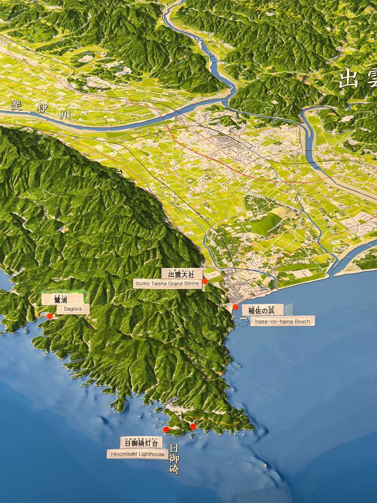
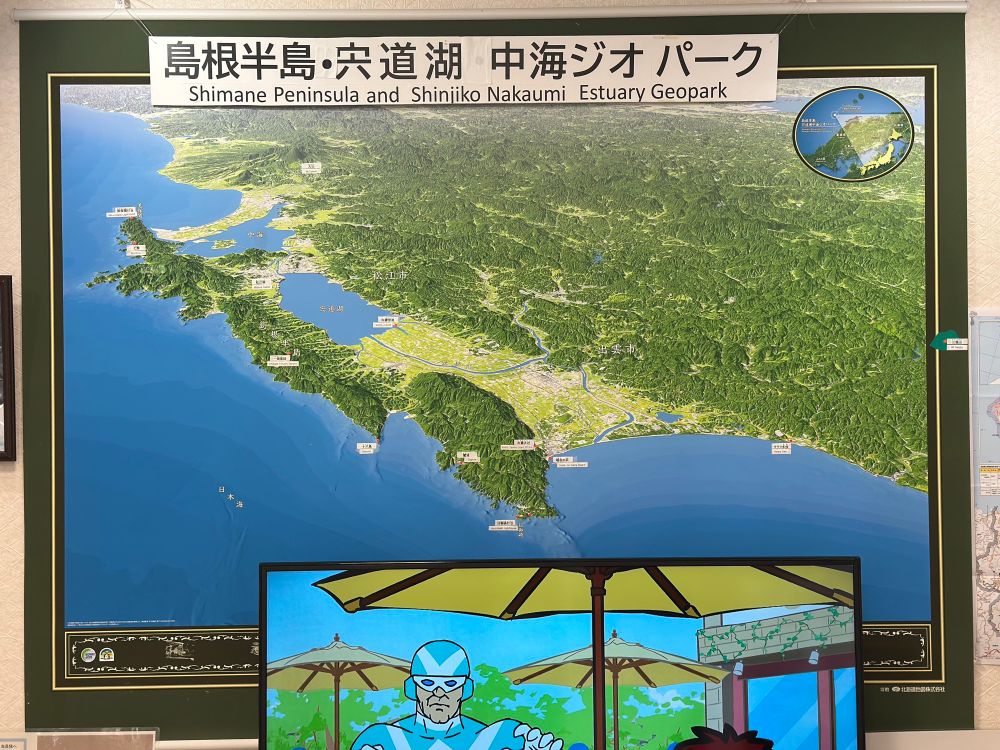
June 9, 2025 at 4:40 AM
#MapsInTheWild Axonometric map of the Shimane Peninsula at the visitor centre of Hinomisaki Lighthouse
Stunning greenish hillshades and subtle ocean depth bluish gradients 🌊⛰️🗾
Stunning greenish hillshades and subtle ocean depth bluish gradients 🌊⛰️🗾
Back to a #QGIS #cartography project of mapping land use distribution in Mong Kok, Hong Kong by breaking down land into 6 key categories.
Together with small multiples showing area of: built structure, carriageway, footway, back-lane, open space, and others
Together with small multiples showing area of: built structure, carriageway, footway, back-lane, open space, and others
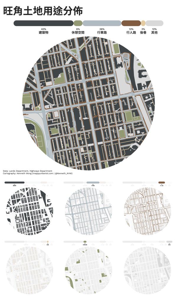
May 26, 2025 at 1:25 PM
Back to a #QGIS #cartography project of mapping land use distribution in Mong Kok, Hong Kong by breaking down land into 6 key categories.
Together with small multiples showing area of: built structure, carriageway, footway, back-lane, open space, and others
Together with small multiples showing area of: built structure, carriageway, footway, back-lane, open space, and others
#MapsInTheWild Topography of Izu Pensisula with illustrations of plate tectonics of the area in Mishima, Shizuoka 🌋🗻
Brings me back the vibes of old high school geography textbook
Brings me back the vibes of old high school geography textbook
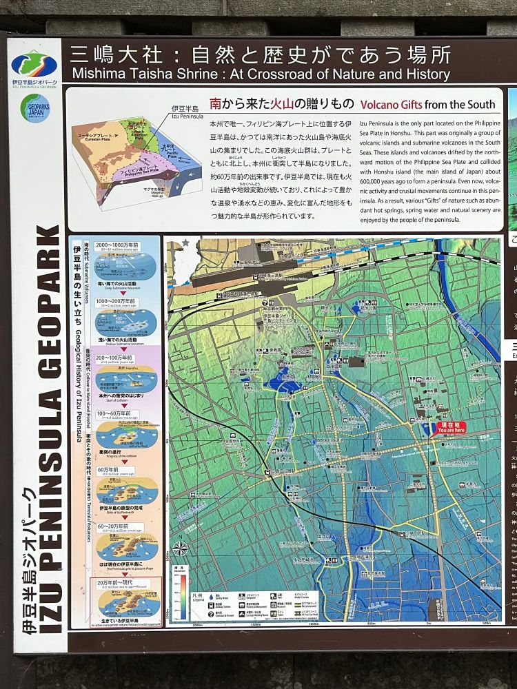
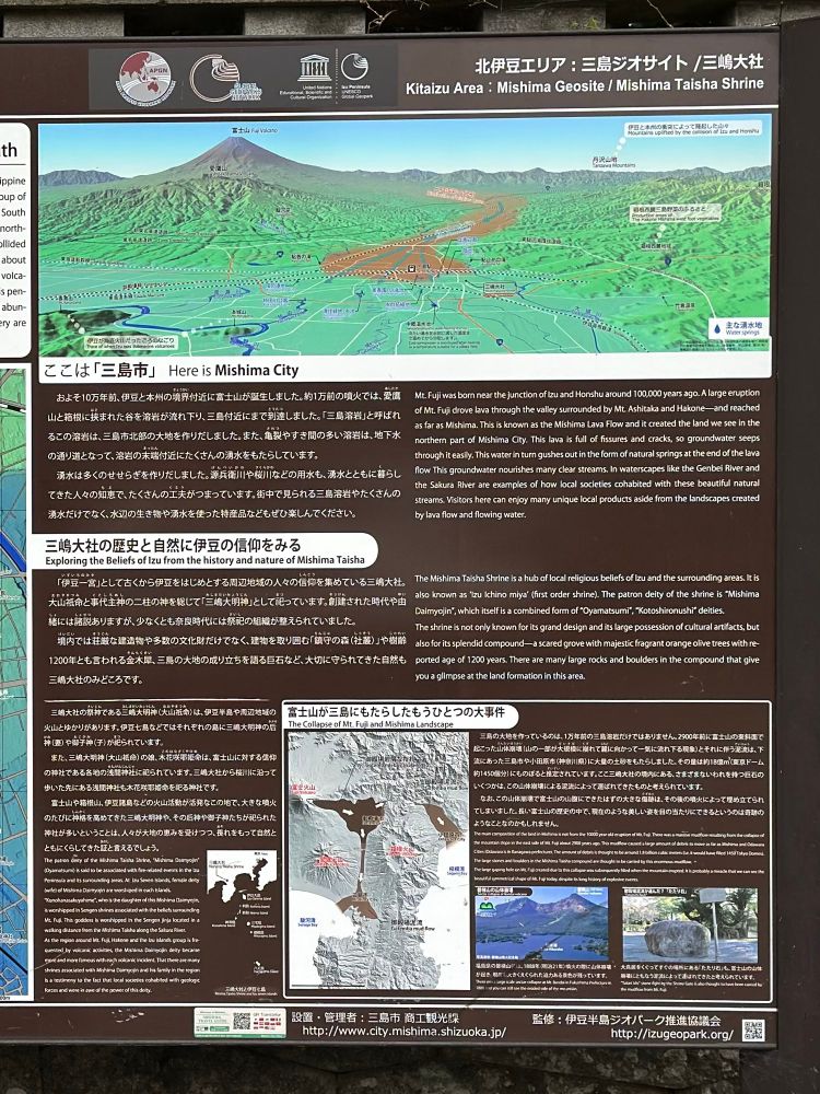
April 29, 2025 at 8:26 PM
#MapsInTheWild Topography of Izu Pensisula with illustrations of plate tectonics of the area in Mishima, Shizuoka 🌋🗻
Brings me back the vibes of old high school geography textbook
Brings me back the vibes of old high school geography textbook