


Kenneth Wong
@kennethkhw.bsky.social
Urbanist, Map nerd, GIS, #RStats
🔗 mappyurbanist.com
🔗 mappyurbanist.com
#30DayMapChallenge Day 13 - 10 minute map
Reachable areas within a 10-minute walk / 10-min isochrones of Yamanote Line (山手線) stations
And yes, the map took much longer than 10 mins to make, sorry not sorry
Reachable areas within a 10-minute walk / 10-min isochrones of Yamanote Line (山手線) stations
And yes, the map took much longer than 10 mins to make, sorry not sorry

November 13, 2025 at 3:29 PM
#30DayMapChallenge Day 13 - 10 minute map
Reachable areas within a 10-minute walk / 10-min isochrones of Yamanote Line (山手線) stations
And yes, the map took much longer than 10 mins to make, sorry not sorry
Reachable areas within a 10-minute walk / 10-min isochrones of Yamanote Line (山手線) stations
And yes, the map took much longer than 10 mins to make, sorry not sorry

November 11, 2025 at 11:06 AM
#30DayMapChallenge Day 8 - Urban
Betweenness centrality of the pedestrian network within 2 km of selected Taiwan's train Stations (Taipei, Taichung, Kaohsiung)
Warming up with OSMnx again
Betweenness centrality of the pedestrian network within 2 km of selected Taiwan's train Stations (Taipei, Taichung, Kaohsiung)
Warming up with OSMnx again

November 9, 2025 at 5:53 PM
#30DayMapChallenge Day 8 - Urban
Betweenness centrality of the pedestrian network within 2 km of selected Taiwan's train Stations (Taipei, Taichung, Kaohsiung)
Warming up with OSMnx again
Betweenness centrality of the pedestrian network within 2 km of selected Taiwan's train Stations (Taipei, Taichung, Kaohsiung)
Warming up with OSMnx again
#30DayMapChallenge Day 6 - Dimensions
Pseudo-3D / 2.5D “axonometric” site plans of several districts in Hong Kong (Wan Chai, Kwun Tong, Tsuen Wan)
Pseudo-3D / 2.5D “axonometric” site plans of several districts in Hong Kong (Wan Chai, Kwun Tong, Tsuen Wan)


November 7, 2025 at 5:02 AM
#30DayMapChallenge Day 6 - Dimensions
Pseudo-3D / 2.5D “axonometric” site plans of several districts in Hong Kong (Wan Chai, Kwun Tong, Tsuen Wan)
Pseudo-3D / 2.5D “axonometric” site plans of several districts in Hong Kong (Wan Chai, Kwun Tong, Tsuen Wan)
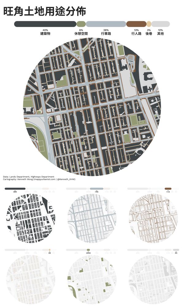
#30DayMapChallenge Day 3 - Polygons
Land use distribution of Mong Kok, Hong Kong
Classified into 6 major categories: built structure, open space, carriageway, footway, alleyway, others
Land use distribution of Mong Kok, Hong Kong
Classified into 6 major categories: built structure, open space, carriageway, footway, alleyway, others

November 3, 2025 at 3:06 PM
#30DayMapChallenge Day 3 - Polygons
Land use distribution of Mong Kok, Hong Kong
Classified into 6 major categories: built structure, open space, carriageway, footway, alleyway, others
Land use distribution of Mong Kok, Hong Kong
Classified into 6 major categories: built structure, open space, carriageway, footway, alleyway, others

November 2, 2025 at 12:38 PM

October 31, 2025 at 4:36 PM
*Some ffmpeg command testing*

June 12, 2025 at 4:28 AM
*Some ffmpeg command testing*
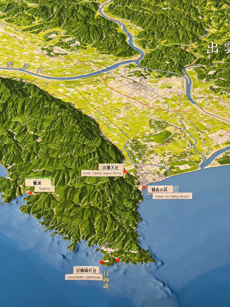
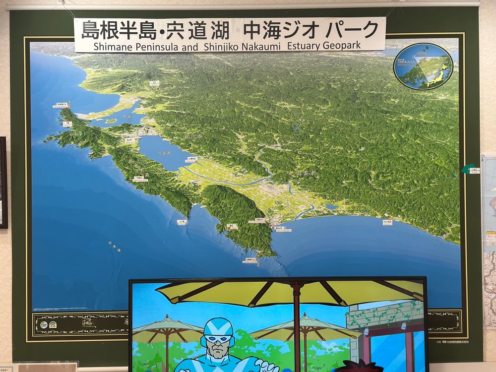
#MapsInTheWild Axonometric map of the Shimane Peninsula at the visitor centre of Hinomisaki Lighthouse
Stunning greenish hillshades and subtle ocean depth bluish gradients 🌊⛰️🗾
Stunning greenish hillshades and subtle ocean depth bluish gradients 🌊⛰️🗾
June 9, 2025 at 4:40 AM
#MapsInTheWild Axonometric map of the Shimane Peninsula at the visitor centre of Hinomisaki Lighthouse
Stunning greenish hillshades and subtle ocean depth bluish gradients 🌊⛰️🗾
Stunning greenish hillshades and subtle ocean depth bluish gradients 🌊⛰️🗾
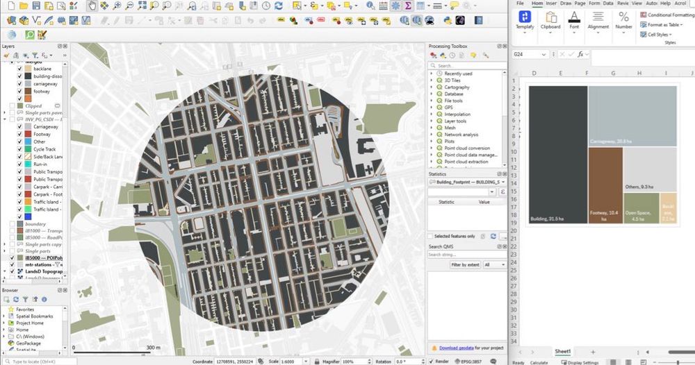
Back to a #QGIS #cartography project of mapping land use distribution in Mong Kok, Hong Kong by breaking down land into 6 key categories.
Together with small multiples showing area of: built structure, carriageway, footway, back-lane, open space, and others
Together with small multiples showing area of: built structure, carriageway, footway, back-lane, open space, and others
May 26, 2025 at 1:25 PM
Back to a #QGIS #cartography project of mapping land use distribution in Mong Kok, Hong Kong by breaking down land into 6 key categories.
Together with small multiples showing area of: built structure, carriageway, footway, back-lane, open space, and others
Together with small multiples showing area of: built structure, carriageway, footway, back-lane, open space, and others
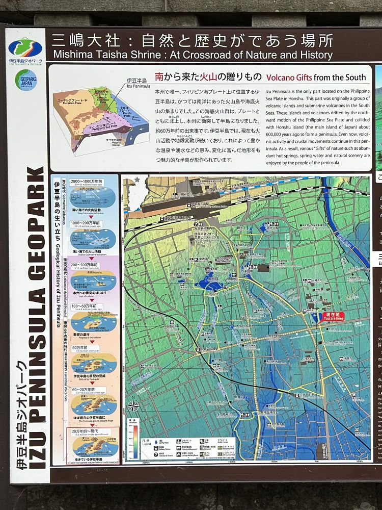
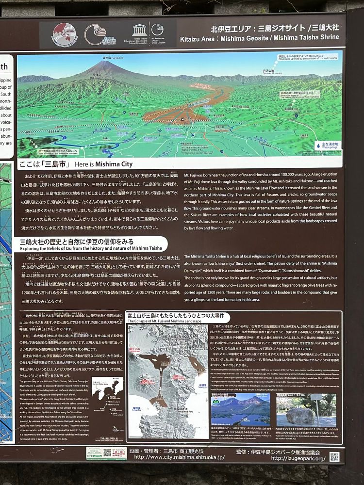
#MapsInTheWild Topography of Izu Pensisula with illustrations of plate tectonics of the area in Mishima, Shizuoka 🌋🗻
Brings me back the vibes of old high school geography textbook
Brings me back the vibes of old high school geography textbook
April 29, 2025 at 8:26 PM
#MapsInTheWild Topography of Izu Pensisula with illustrations of plate tectonics of the area in Mishima, Shizuoka 🌋🗻
Brings me back the vibes of old high school geography textbook
Brings me back the vibes of old high school geography textbook
Working on bus route data and got distracted into playing with line symbology again #MapInProgress
April 15, 2025 at 5:57 PM
Working on bus route data and got distracted into playing with line symbology again #MapInProgress
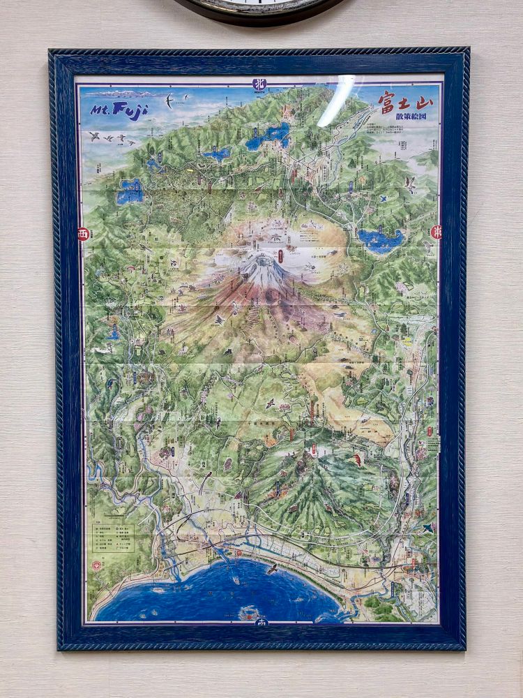
#MapsInTheWild a detailed illustration of Mount Fuji’s surrounding areas 🗻
Found this map at Mishima Taisha Shrine. The deeper you explore the map, the more intricate details you could uncover
Found this map at Mishima Taisha Shrine. The deeper you explore the map, the more intricate details you could uncover
April 9, 2025 at 2:48 PM
#MapsInTheWild a detailed illustration of Mount Fuji’s surrounding areas 🗻
Found this map at Mishima Taisha Shrine. The deeper you explore the map, the more intricate details you could uncover
Found this map at Mishima Taisha Shrine. The deeper you explore the map, the more intricate details you could uncover
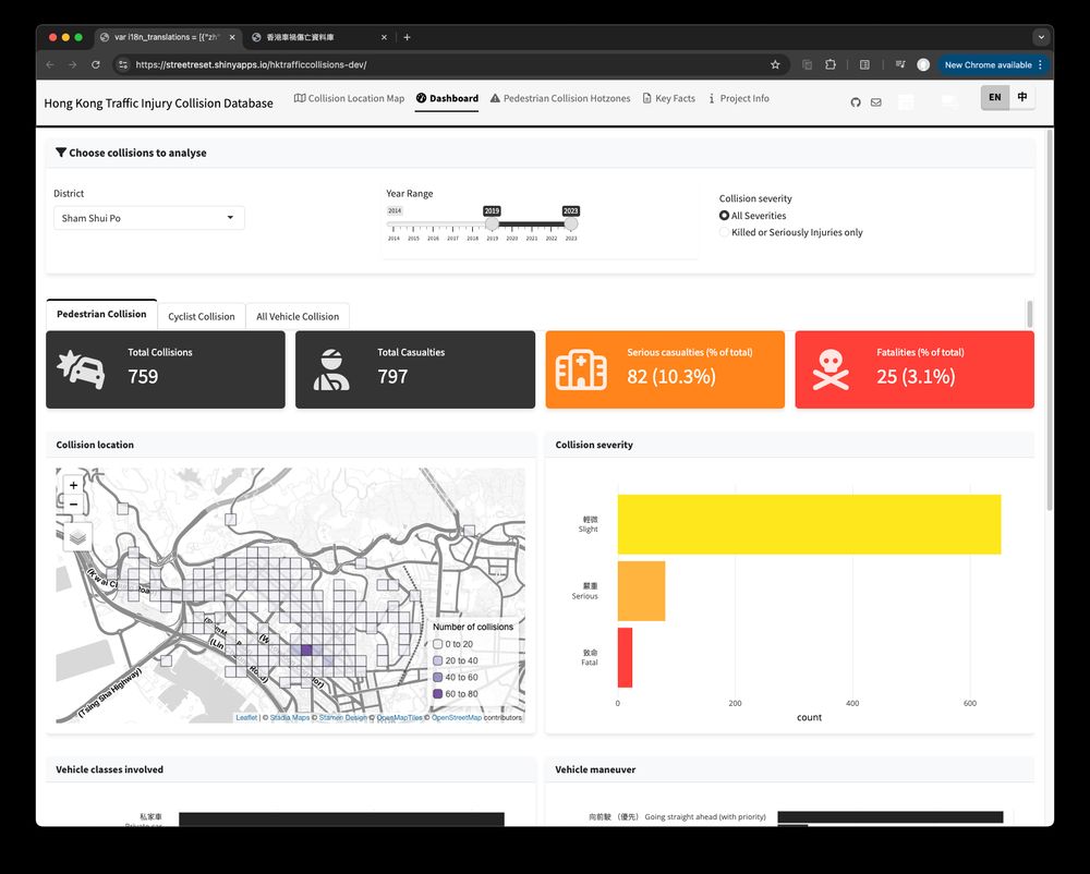
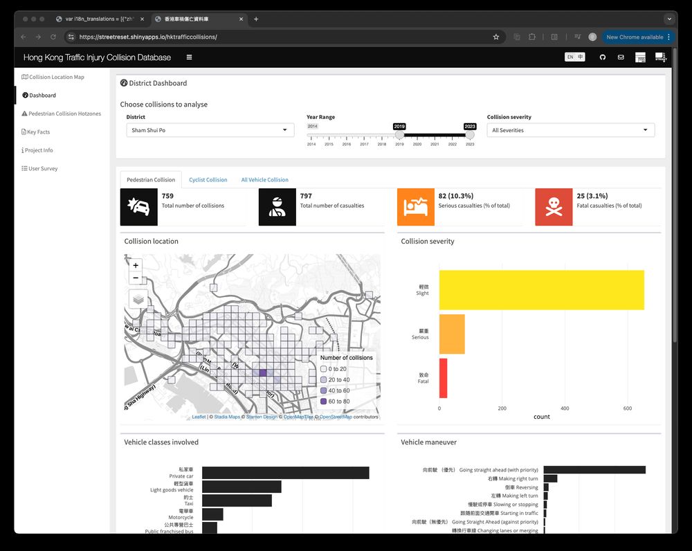
Asked Cursor with Claude 3.7 to give my #RStats shiny app a facelift by switching {shinydashboard} to {bslib}
Spent an extra day to fix the broken bits, tweak the flows and polish the UI - but it’s still slick that I even have no idea where to start without Claude
Spent an extra day to fix the broken bits, tweak the flows and polish the UI - but it’s still slick that I even have no idea where to start without Claude
March 5, 2025 at 4:19 PM
Asked Cursor with Claude 3.7 to give my #RStats shiny app a facelift by switching {shinydashboard} to {bslib}
Spent an extra day to fix the broken bits, tweak the flows and polish the UI - but it’s still slick that I even have no idea where to start without Claude
Spent an extra day to fix the broken bits, tweak the flows and polish the UI - but it’s still slick that I even have no idea where to start without Claude
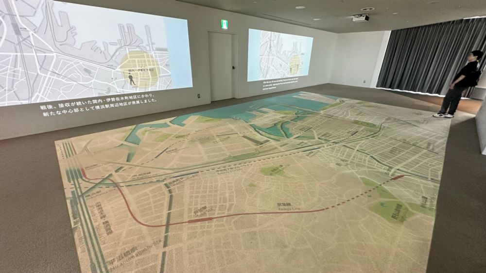
#MapsInTheWild a giant map of Yokohama on Yokohama Landmark Tower’s observation deck
An enormous map spreading out the floor is always a cool thing to me
An enormous map spreading out the floor is always a cool thing to me
February 19, 2025 at 4:28 PM
#MapsInTheWild a giant map of Yokohama on Yokohama Landmark Tower’s observation deck
An enormous map spreading out the floor is always a cool thing to me
An enormous map spreading out the floor is always a cool thing to me
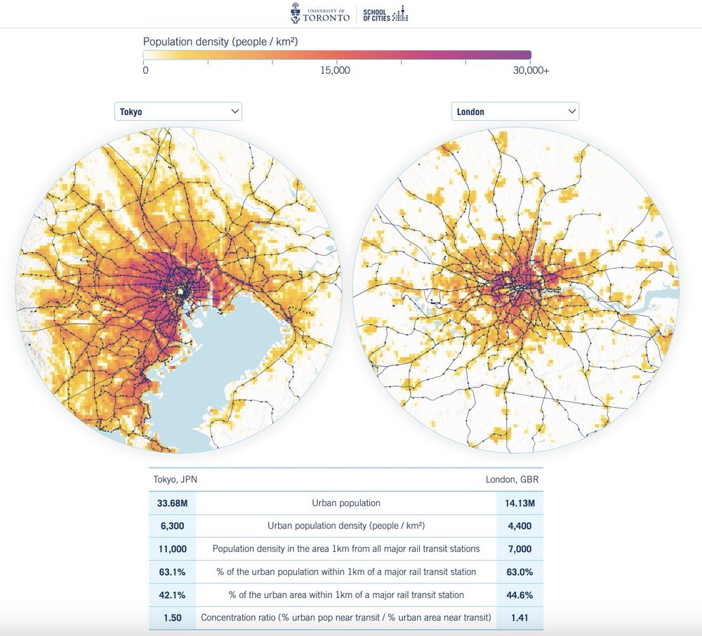
Calling all map/urban/railway nerds to check out this website visualising railway accessibility across 250 cities around the globe by Aniket Kali and @jamaps.bsky.social - stunning #cartography and #dataviz
🔗 schoolofcities.github.io/rail-transit...
#gischat
🔗 schoolofcities.github.io/rail-transit...
#gischat
February 12, 2025 at 4:46 PM
Calling all map/urban/railway nerds to check out this website visualising railway accessibility across 250 cities around the globe by Aniket Kali and @jamaps.bsky.social - stunning #cartography and #dataviz
🔗 schoolofcities.github.io/rail-transit...
#gischat
🔗 schoolofcities.github.io/rail-transit...
#gischat
#30DayMapChallenge Day 16 - Choropleth
Interactive map of median household income distribution in Hong Kong, made with #RStats
Challenging myself to create a non-static and non-QGIS map, despite a late submission 🤐
#RSpatial
Interactive map of median household income distribution in Hong Kong, made with #RStats
Challenging myself to create a non-static and non-QGIS map, despite a late submission 🤐
#RSpatial
February 5, 2025 at 4:56 PM
#30DayMapChallenge Day 16 - Choropleth
Interactive map of median household income distribution in Hong Kong, made with #RStats
Challenging myself to create a non-static and non-QGIS map, despite a late submission 🤐
#RSpatial
Interactive map of median household income distribution in Hong Kong, made with #RStats
Challenging myself to create a non-static and non-QGIS map, despite a late submission 🤐
#RSpatial
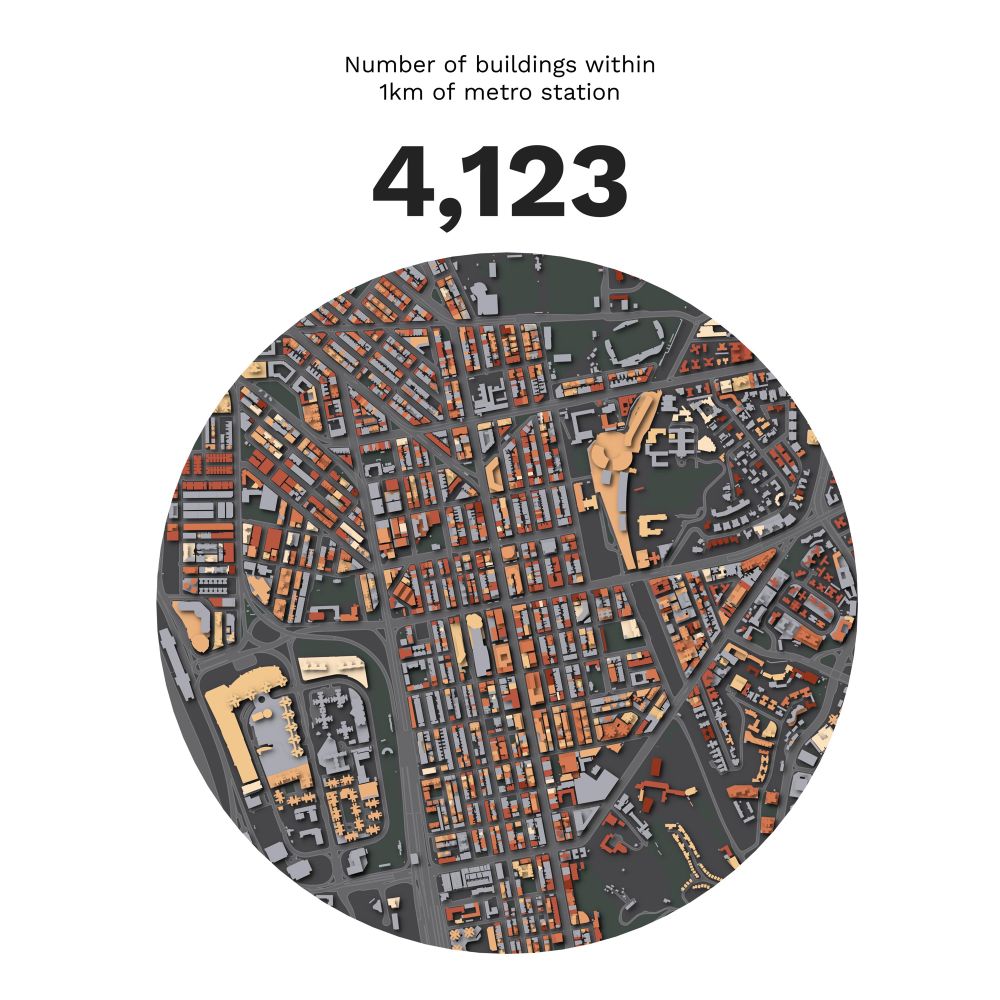
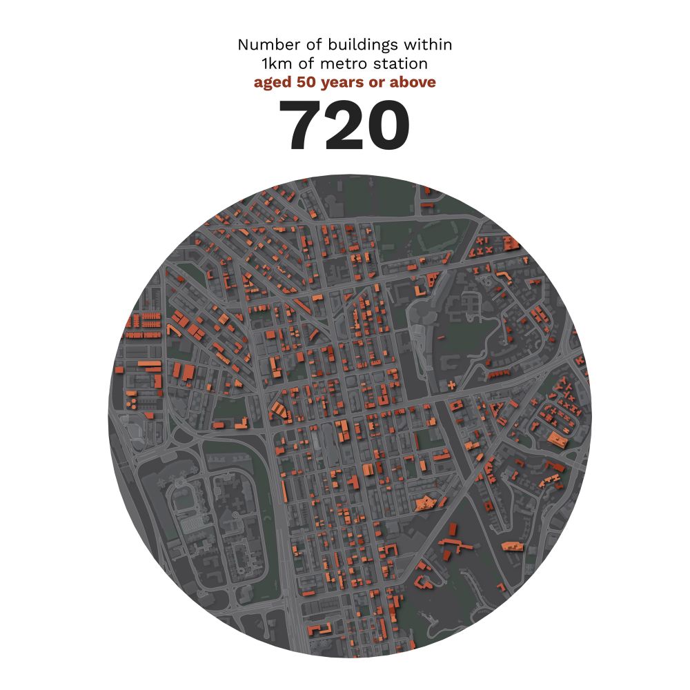
The completed map: Building age distribution around three selected Hong Kong MTR stations
Left one shows total building count, right one displays buildings 50+ years old 🏙️🗺️
Left one shows total building count, right one displays buildings 50+ years old 🏙️🗺️

January 29, 2025 at 6:36 PM
The completed map: Building age distribution around three selected Hong Kong MTR stations
Left one shows total building count, right one displays buildings 50+ years old 🏙️🗺️
Left one shows total building count, right one displays buildings 50+ years old 🏙️🗺️
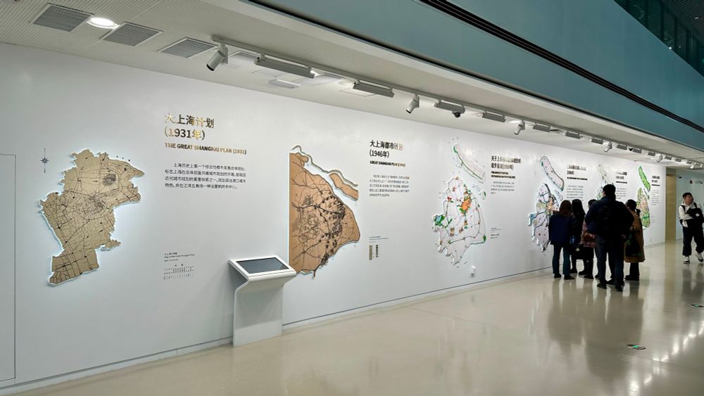
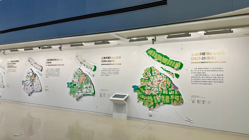
#MapsInTheWild 6 masterplans of Shanghai, from 1930 to 2017, in Shanghai Urban Planning Exhibition Center
January 23, 2025 at 3:50 PM
#MapsInTheWild 6 masterplans of Shanghai, from 1930 to 2017, in Shanghai Urban Planning Exhibition Center
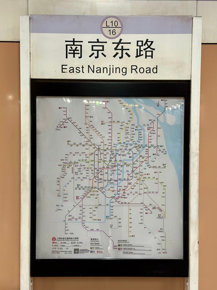
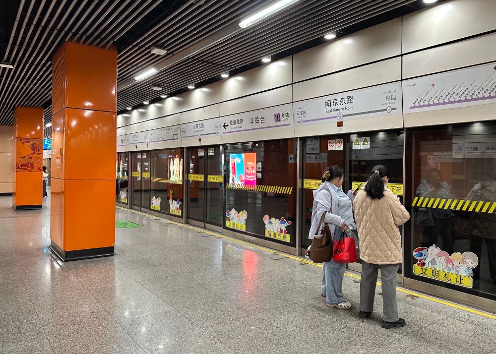
First visit to Shanghai on the weekend - Taking photos of the station and tube map is a must-do for map nerds and railway nerds
January 20, 2025 at 3:24 PM
First visit to Shanghai on the weekend - Taking photos of the station and tube map is a must-do for map nerds and railway nerds
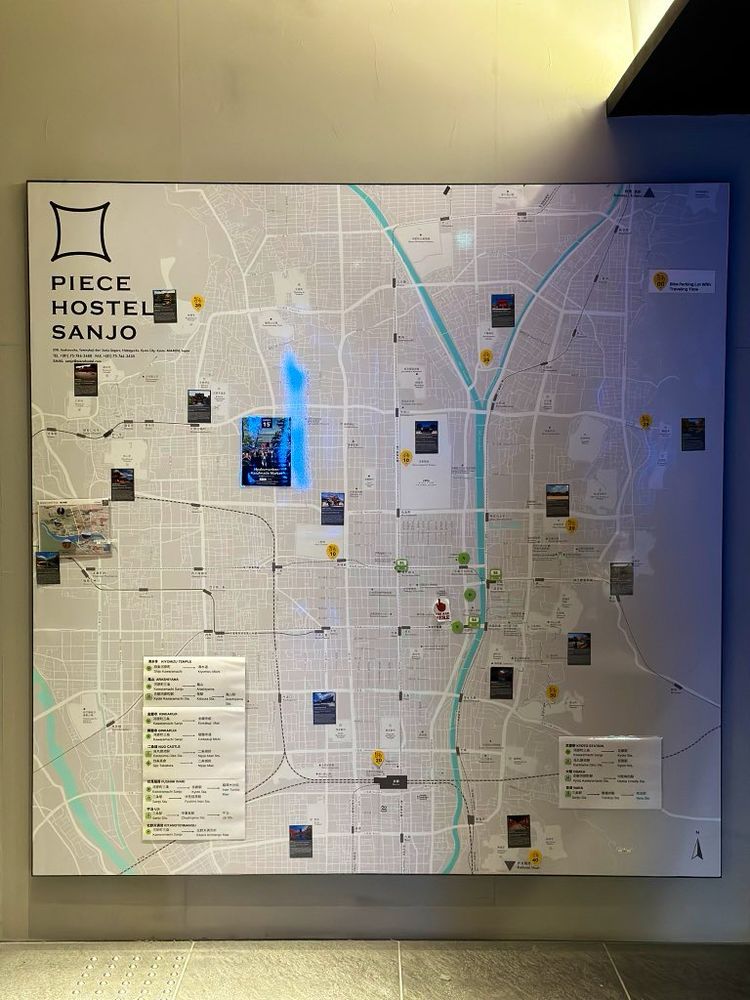
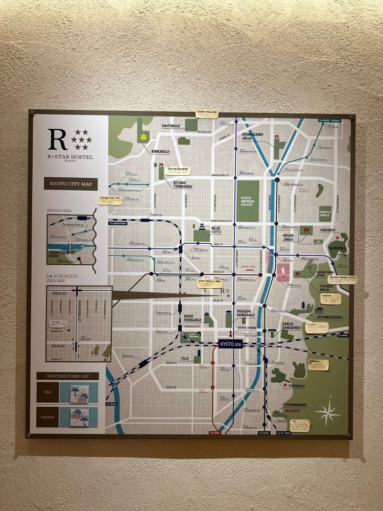
#MapsInTheWild two hostels I stayed in Kyoto last Nov. Both have a gigantic city map hung near reception.
Comparing the differences of their approaches to map the town and show the tourist spots would be a great cartography article
Comparing the differences of their approaches to map the town and show the tourist spots would be a great cartography article
January 14, 2025 at 5:48 PM
#MapsInTheWild two hostels I stayed in Kyoto last Nov. Both have a gigantic city map hung near reception.
Comparing the differences of their approaches to map the town and show the tourist spots would be a great cartography article
Comparing the differences of their approaches to map the town and show the tourist spots would be a great cartography article
#MapInProgress (and a building age analysis article in progress)
January 11, 2025 at 2:57 PM
#MapInProgress (and a building age analysis article in progress)
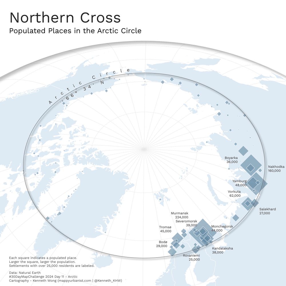
#30DayMapChallenge Day 11 - Arctic
Populated Places in the Arctic Circle
Stumbled across Rovaniemi (home of Santa Claus Village) when doing some Christmas research, and ended up in the rabbit hole of exploring towns in the Arctic Circle
Mappy Christmas to you all also! 🎄🎅
Populated Places in the Arctic Circle
Stumbled across Rovaniemi (home of Santa Claus Village) when doing some Christmas research, and ended up in the rabbit hole of exploring towns in the Arctic Circle
Mappy Christmas to you all also! 🎄🎅
December 24, 2024 at 7:23 PM
#30DayMapChallenge Day 11 - Arctic
Populated Places in the Arctic Circle
Stumbled across Rovaniemi (home of Santa Claus Village) when doing some Christmas research, and ended up in the rabbit hole of exploring towns in the Arctic Circle
Mappy Christmas to you all also! 🎄🎅
Populated Places in the Arctic Circle
Stumbled across Rovaniemi (home of Santa Claus Village) when doing some Christmas research, and ended up in the rabbit hole of exploring towns in the Arctic Circle
Mappy Christmas to you all also! 🎄🎅
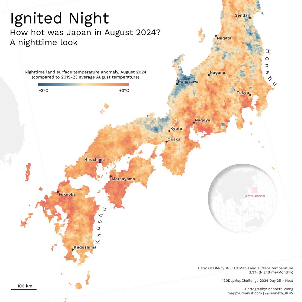
#30DayMapChallenge Day 25 - Heat
Nighttime land surface temperature anomaly in Japan, August 2024 (compared to 2019-23 average August temperature)
It was not a hot summer, but a *scorching* hot summer in Tokyo
Nighttime land surface temperature anomaly in Japan, August 2024 (compared to 2019-23 average August temperature)
It was not a hot summer, but a *scorching* hot summer in Tokyo
November 26, 2024 at 2:47 AM
#30DayMapChallenge Day 25 - Heat
Nighttime land surface temperature anomaly in Japan, August 2024 (compared to 2019-23 average August temperature)
It was not a hot summer, but a *scorching* hot summer in Tokyo
Nighttime land surface temperature anomaly in Japan, August 2024 (compared to 2019-23 average August temperature)
It was not a hot summer, but a *scorching* hot summer in Tokyo