


James G. LaDue (Jim)
@jladue.bsky.social
Meteorologist, passionate about severe local storms, winter weather, better community resilience against hazards, photography, sailing, skiing, hiking, democratic discourse, family, travel.
Former NWIRP acting Director, teaching severe storms for awhile
Former NWIRP acting Director, teaching severe storms for awhile
I’ve been near tornadoes with violent sounding roars. It’s a level 5 experience for sure. We do need more DIs capable of evaluating high end tornadoes without there needing to be a disaster to do so.
May 22, 2025 at 11:28 PM
I’ve been near tornadoes with violent sounding roars. It’s a level 5 experience for sure. We do need more DIs capable of evaluating high end tornadoes without there needing to be a disaster to do so.
You may see specks and dots appear in the first part of the time lapse. That was hail falling, a few stones bigger than golfballs. Luckily they didn't hit the cameras. The tornado was rated EF2.
May 21, 2025 at 3:35 AM
You may see specks and dots appear in the first part of the time lapse. That was hail falling, a few stones bigger than golfballs. Luckily they didn't hit the cameras. The tornado was rated EF2.
Here's the Arnette, OK supercell/tornado time lapse from May 18. I haven't gotten a full tornado time lapse in quite some time, like ever.
youtu.be/Y2zl1W2PMFw
youtu.be/Y2zl1W2PMFw

20250518 ArnetteOKstorm
YouTube video by James G. LaDue
youtu.be
May 21, 2025 at 3:35 AM
Here's the Arnette, OK supercell/tornado time lapse from May 18. I haven't gotten a full tornado time lapse in quite some time, like ever.
youtu.be/Y2zl1W2PMFw
youtu.be/Y2zl1W2PMFw
This is interesting. I hope the pub doesn’t disappear by the time im ready to read it.
May 9, 2025 at 2:59 PM
This is interesting. I hope the pub doesn’t disappear by the time im ready to read it.
And neighbor’s usage of herbicide is bad too.
May 1, 2025 at 9:04 PM
And neighbor’s usage of herbicide is bad too.
I'm sure glad the radars are still running so we can see what a hailer can do to splatter the S-band radiation in all sorts of directions, whether from side lobes or the main beam. Earth is going to get close to this.#txwx

April 24, 2025 at 2:43 AM
I'm sure glad the radars are still running so we can see what a hailer can do to splatter the S-band radiation in all sorts of directions, whether from side lobes or the main beam. Earth is going to get close to this.#txwx
It’s going ballistic!
April 18, 2025 at 1:53 AM
It’s going ballistic!


Reposted by James G. LaDue (Jim)

The thing about tools like cli-MATE and ACIS is not that the data won't exist (not yet at least). It's that they make getting the information you want so...efficient.
Can I write some code to do the same task? Sure, but not everyone can, and why should we need to when a great tool already exists?
Can I write some code to do the same task? Sure, but not everyone can, and why should we need to when a great tool already exists?

Some news. Those of you that utilize the cli-MATE tool from the Midwest Regional Climate Center will no longer have access unless funding is restored before the 17th.
A huge loss.
A huge loss.
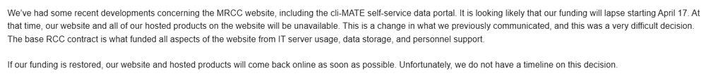
April 16, 2025 at 9:32 PM
The thing about tools like cli-MATE and ACIS is not that the data won't exist (not yet at least). It's that they make getting the information you want so...efficient.
Can I write some code to do the same task? Sure, but not everyone can, and why should we need to when a great tool already exists?
Can I write some code to do the same task? Sure, but not everyone can, and why should we need to when a great tool already exists?
This lab makes it possible for the NWS to forecast severe weather at the level we do. They can do much more too. If lost there’s no going back to fix it.
HRRR? RRFS? Those models don’t exist without NOAA’s Global Systems Lab.
The physics used in even more models? Not possible without us.
Decision-support tools like DESI and IDSS Engine used throughout the NWS? Also us.
What my lab does is *integral* to weather prediction and keeping people safe.
The physics used in even more models? Not possible without us.
Decision-support tools like DESI and IDSS Engine used throughout the NWS? Also us.
What my lab does is *integral* to weather prediction and keeping people safe.
April 17, 2025 at 10:43 AM
This lab makes it possible for the NWS to forecast severe weather at the level we do. They can do much more too. If lost there’s no going back to fix it.
Here's another Friday with more anger-inciting announcements, this one being the worst.
April 12, 2025 at 1:23 AM
Here's another Friday with more anger-inciting announcements, this one being the worst.
After a super windy March, this is a nice change in #okwx. This was taken from a race hosted by the Lake Thunderbird Education Foundation. thunderbirdsailingclub.org

April 10, 2025 at 3:16 AM
After a super windy March, this is a nice change in #okwx. This was taken from a race hosted by the Lake Thunderbird Education Foundation. thunderbirdsailingclub.org
Check out the 75 mph gust and near 10mb oscillation in at the Ringling, OK Mesonet site!


April 5, 2025 at 9:34 AM
Check out the 75 mph gust and near 10mb oscillation in at the Ringling, OK Mesonet site!
Look at Byers gusting to 63 mph!

April 5, 2025 at 8:58 AM
Look at Byers gusting to 63 mph!
Third night in a row of a gravity wave flying through OK. This one’s enough to reverse a 40 mph north wind to a 60 mph south wind.
April 5, 2025 at 8:57 AM
Third night in a row of a gravity wave flying through OK. This one’s enough to reverse a 40 mph north wind to a 60 mph south wind.
Look, a gravity wave.

April 4, 2025 at 10:22 AM
Look, a gravity wave.
The odds this has a tornado origin are pretty low because I cannot see any enhanced azimuthal shear and there is a lack of convective precip. But there's 6kft of air below the beam.
April 3, 2025 at 3:09 AM
The odds this has a tornado origin are pretty low because I cannot see any enhanced azimuthal shear and there is a lack of convective precip. But there's 6kft of air below the beam.
Here's an odd CC drop that looks like a distant debris signature SE of Van Wert, OH. It's along a shear zone but not associated with a significant reflectivity line. That's to the SW. But I can't rule out a tornado either.
April 3, 2025 at 3:05 AM
Here's an odd CC drop that looks like a distant debris signature SE of Van Wert, OH. It's along a shear zone but not associated with a significant reflectivity line. That's to the SW. But I can't rule out a tornado either.
Look upstairs and see some amazing supercell updraft signatures NW of Memphis.

April 3, 2025 at 1:13 AM
Look upstairs and see some amazing supercell updraft signatures NW of Memphis.
Here are a few more moments


April 1, 2025 at 2:13 AM
Here are a few more moments
This supercell east of Cheyenne went up with surface temps in the mid 40's F. The storm appeared to have little rain, a lot of ice, and a rather prominent peak. It's got high Zdrs (much higher than anything down low), very low CCs and high spectrum widths. I've got my own idea what it is.


April 1, 2025 at 2:12 AM
This supercell east of Cheyenne went up with surface temps in the mid 40's F. The storm appeared to have little rain, a lot of ice, and a rather prominent peak. It's got high Zdrs (much higher than anything down low), very low CCs and high spectrum widths. I've got my own idea what it is.
Look at that string of updrafts (circled in the lower right).

March 30, 2025 at 3:53 AM
Look at that string of updrafts (circled in the lower right).
Here's the left split. Best anticyclonic rotation is up at 20 kft.

March 30, 2025 at 3:06 AM
Here's the left split. Best anticyclonic rotation is up at 20 kft.
Is this why the only rotating storm I see is the left mover passing over Chickasha? Knock off the lowest 700m of flow and it's all negative SRH.

March 30, 2025 at 3:00 AM
Is this why the only rotating storm I see is the left mover passing over Chickasha? Knock off the lowest 700m of flow and it's all negative SRH.
Thunderstorm gravity waves are flying through the Northern Lower MI peninsula. That means high wind gusts even with low 30s F temps. Cool! See the paper by Borchardt and co-authors. doi.org/10.1175/WAF-...
March 29, 2025 at 2:54 AM
Thunderstorm gravity waves are flying through the Northern Lower MI peninsula. That means high wind gusts even with low 30s F temps. Cool! See the paper by Borchardt and co-authors. doi.org/10.1175/WAF-...