


Humap: the digital humanities map platform
@humap.bsky.social
🗺️ Bring your collections, data, and research to life with geospatial storytelling
https://humap.me/
#GLAMA #DigitalHumanities #EdTech #CitizenScience #CitizenHumanities
https://humap.me/
#GLAMA #DigitalHumanities #EdTech #CitizenScience #CitizenHumanities
Pinned

🗺️ Hi Bluesky! We're Humap, a map platform built with and for #GLAMA, #DigitalHumanities, and #CitizenScience
Here are some of the amazing projects on our platform 🧵
An archival history of #Tampa #Florida created by the University of South Florida tampa-through-time.humap.site
#USHistory #USA
Here are some of the amazing projects on our platform 🧵
An archival history of #Tampa #Florida created by the University of South Florida tampa-through-time.humap.site
#USHistory #USA
Reposted by Humap: the digital humanities map platform
Our popular GIS Workshop Series 🌐 begins on Jan 28, runs weeklyish Wednesdays 2-3pm, meeting in-person in SLab's Common Room (Shannon Library 308). Zero experience needed, & non-UVA folks are very welcome! Overview of this terms GIS workshops here 🎩
January 20, 2026 at 9:32 AM
Our popular GIS Workshop Series 🌐 begins on Jan 28, runs weeklyish Wednesdays 2-3pm, meeting in-person in SLab's Common Room (Shannon Library 308). Zero experience needed, & non-UVA folks are very welcome! Overview of this terms GIS workshops here 🎩
Reposted by Humap: the digital humanities map platform
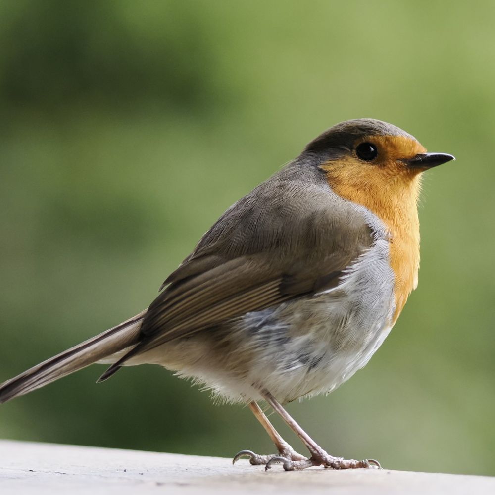
#BirdOfTheDay theme is #FeedingTime. This is from last Spring - a White-throated Dipper (Cinclus cinclus) feeding a juvenile.
The White-throated Dipper is the national bird of Norway, although this one was in the UK.
#birds #photography
The White-throated Dipper is the national bird of Norway, although this one was in the UK.
#birds #photography

January 20, 2026 at 9:05 AM
#BirdOfTheDay theme is #FeedingTime. This is from last Spring - a White-throated Dipper (Cinclus cinclus) feeding a juvenile.
The White-throated Dipper is the national bird of Norway, although this one was in the UK.
#birds #photography
The White-throated Dipper is the national bird of Norway, although this one was in the UK.
#birds #photography
Reposted by Humap: the digital humanities map platform
Good morning to everyone, but especially to all the penguins, for today is their special day!
This engraving of a 'Patagonian Penguin' can be found in 'Animated Nature Vol. 2' (1821) by Georges-Louis Leclerc, Comte de Buffon.
📷 Reserve 590 BUF
#PenguinAwarenessDay #PenguinDay #RareBooks
This engraving of a 'Patagonian Penguin' can be found in 'Animated Nature Vol. 2' (1821) by Georges-Louis Leclerc, Comte de Buffon.
📷 Reserve 590 BUF
#PenguinAwarenessDay #PenguinDay #RareBooks

January 20, 2026 at 10:08 AM
Good morning to everyone, but especially to all the penguins, for today is their special day!
This engraving of a 'Patagonian Penguin' can be found in 'Animated Nature Vol. 2' (1821) by Georges-Louis Leclerc, Comte de Buffon.
📷 Reserve 590 BUF
#PenguinAwarenessDay #PenguinDay #RareBooks
This engraving of a 'Patagonian Penguin' can be found in 'Animated Nature Vol. 2' (1821) by Georges-Louis Leclerc, Comte de Buffon.
📷 Reserve 590 BUF
#PenguinAwarenessDay #PenguinDay #RareBooks
Reposted by Humap: the digital humanities map platform


January 20, 2026 at 6:59 AM

Reposted by Humap: the digital humanities map platform
Thankfully it's #HillfortsWednesday 🍻🥳🙀
Here's our fabulous @rcahmwales.bsky.social Sketchfab model of the incredible St David's Head coastal promontory fort in Pembrokeshire, surveyed just before Christmas
The rock terrain created a very special place to live ⛰️
Browse online here: skfb.ly/pFoXw
Here's our fabulous @rcahmwales.bsky.social Sketchfab model of the incredible St David's Head coastal promontory fort in Pembrokeshire, surveyed just before Christmas
The rock terrain created a very special place to live ⛰️
Browse online here: skfb.ly/pFoXw
January 14, 2026 at 7:39 AM
Thankfully it's #HillfortsWednesday 🍻🥳🙀
Here's our fabulous @rcahmwales.bsky.social Sketchfab model of the incredible St David's Head coastal promontory fort in Pembrokeshire, surveyed just before Christmas
The rock terrain created a very special place to live ⛰️
Browse online here: skfb.ly/pFoXw
Here's our fabulous @rcahmwales.bsky.social Sketchfab model of the incredible St David's Head coastal promontory fort in Pembrokeshire, surveyed just before Christmas
The rock terrain created a very special place to live ⛰️
Browse online here: skfb.ly/pFoXw
Reposted by Humap: the digital humanities map platform

It's easy to forget that hillforts had a life after the Iron Age
Here's a fine recreation of significant later activity © Peter Dunn / Historic England
It's Aug 1086 and William I has has brought the landowners of England to Old Sarum #Wiltshire to swear allegiance to him
#HillfortsWednesday
Here's a fine recreation of significant later activity © Peter Dunn / Historic England
It's Aug 1086 and William I has has brought the landowners of England to Old Sarum #Wiltshire to swear allegiance to him
#HillfortsWednesday

January 14, 2026 at 5:52 AM
It's easy to forget that hillforts had a life after the Iron Age
Here's a fine recreation of significant later activity © Peter Dunn / Historic England
It's Aug 1086 and William I has has brought the landowners of England to Old Sarum #Wiltshire to swear allegiance to him
#HillfortsWednesday
Here's a fine recreation of significant later activity © Peter Dunn / Historic England
It's Aug 1086 and William I has has brought the landowners of England to Old Sarum #Wiltshire to swear allegiance to him
#HillfortsWednesday
Reposted by Humap: the digital humanities map platform

We have an update on Charlie’s newfound love of printing.

January 14, 2026 at 6:00 PM
We have an update on Charlie’s newfound love of printing.
Reposted by Humap: the digital humanities map platform

This Friday (16/01/26) Miles Russell will be giving a talk entitled "The Durotriges Project: Life and death in Late Iron Age and Early Roman Dorset". The talk is sponsored by @prehistoricsociety.bsky.social. 7.45pm, United Reformed Church hall, Welwyn Garden City. All welcome (visitors £3).

January 14, 2026 at 6:18 PM
This Friday (16/01/26) Miles Russell will be giving a talk entitled "The Durotriges Project: Life and death in Late Iron Age and Early Roman Dorset". The talk is sponsored by @prehistoricsociety.bsky.social. 7.45pm, United Reformed Church hall, Welwyn Garden City. All welcome (visitors £3).
Reposted by Humap: the digital humanities map platform

UCD #CitizenScience event
Met Éireann is calling on the public to help rescue millions of historic weather observations currently held in handwritten paper records.🌀
Dr. Rhonda McGovern will run a free hands-on workshop on 27 Jan in James Joyce Library Link 3.
Register: forms.gle/cXs26gVj68pN...
Met Éireann is calling on the public to help rescue millions of historic weather observations currently held in handwritten paper records.🌀
Dr. Rhonda McGovern will run a free hands-on workshop on 27 Jan in James Joyce Library Link 3.
Register: forms.gle/cXs26gVj68pN...

January 15, 2026 at 9:02 AM
UCD #CitizenScience event
Met Éireann is calling on the public to help rescue millions of historic weather observations currently held in handwritten paper records.🌀
Dr. Rhonda McGovern will run a free hands-on workshop on 27 Jan in James Joyce Library Link 3.
Register: forms.gle/cXs26gVj68pN...
Met Éireann is calling on the public to help rescue millions of historic weather observations currently held in handwritten paper records.🌀
Dr. Rhonda McGovern will run a free hands-on workshop on 27 Jan in James Joyce Library Link 3.
Register: forms.gle/cXs26gVj68pN...
Reposted by Humap: the digital humanities map platform

And as promised, here they be! 🌼Snowdrops spotted at our Woods Mill Nature Reserve by Volunteer Coordinator Julia.
📷 Snowdrops © Julia Hoare
📷 Snowdrops © Julia Hoare

January 15, 2026 at 10:02 AM
And as promised, here they be! 🌼Snowdrops spotted at our Woods Mill Nature Reserve by Volunteer Coordinator Julia.
📷 Snowdrops © Julia Hoare
📷 Snowdrops © Julia Hoare
Reposted by Humap: the digital humanities map platform

There are still places on our 2 day writing course for PhD students . This in-person trainingwill help you with your writing skills and craft with a particular emphasis on style and structure www.history.ac.uk/news-events/...

Short Writing Course for PhD Students
Please enable JavaScript in your web browser to get the best experience.
www.history.ac.uk
January 15, 2026 at 10:15 AM
There are still places on our 2 day writing course for PhD students . This in-person trainingwill help you with your writing skills and craft with a particular emphasis on style and structure www.history.ac.uk/news-events/...
Reposted by Humap: the digital humanities map platform

📣 Call for Papers - EAA 2026 Athens
Papers are invited for a session organised by the ADS related to the broad area of metadata enrichment, FAIR principles, and engaging content for user communities.
🗒️ Papers, 15 min
🕑 Deadline: 28 January 2026
For more information please visit: buff.ly/G5f4pi2
Papers are invited for a session organised by the ADS related to the broad area of metadata enrichment, FAIR principles, and engaging content for user communities.
🗒️ Papers, 15 min
🕑 Deadline: 28 January 2026
For more information please visit: buff.ly/G5f4pi2

January 15, 2026 at 10:20 AM
📣 Call for Papers - EAA 2026 Athens
Papers are invited for a session organised by the ADS related to the broad area of metadata enrichment, FAIR principles, and engaging content for user communities.
🗒️ Papers, 15 min
🕑 Deadline: 28 January 2026
For more information please visit: buff.ly/G5f4pi2
Papers are invited for a session organised by the ADS related to the broad area of metadata enrichment, FAIR principles, and engaging content for user communities.
🗒️ Papers, 15 min
🕑 Deadline: 28 January 2026
For more information please visit: buff.ly/G5f4pi2
Reposted by Humap: the digital humanities map platform

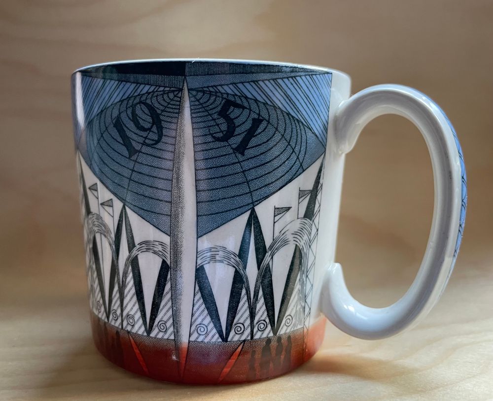
Wedgwood Festival of Britain mug, designed by Norman Makinson, & depicting the Skylon and Crystal Palace.


January 24, 2025 at 12:50 PM
Wedgwood Festival of Britain mug, designed by Norman Makinson, & depicting the Skylon and Crystal Palace.
Reposted by Humap: the digital humanities map platform

Dear Digital Humanists, you are all invited to the EADH 2026 Conference! We are meeting in September, in Kraków, Poland.
Mark the important dates in your calendars:
📆 8.02: submission deadline
📆 15-19.09: the conference
Read more: eadh2026.confer.uj.edu.pl
✈️ See you in Kraków?
Mark the important dates in your calendars:
📆 8.02: submission deadline
📆 15-19.09: the conference
Read more: eadh2026.confer.uj.edu.pl
✈️ See you in Kraków?
EADH 2026 - Jagiellońskie Centrum Humanistyki Cyfrowej
eadh2026.confer.uj.edu.pl
January 13, 2026 at 3:53 PM
Dear Digital Humanists, you are all invited to the EADH 2026 Conference! We are meeting in September, in Kraków, Poland.
Mark the important dates in your calendars:
📆 8.02: submission deadline
📆 15-19.09: the conference
Read more: eadh2026.confer.uj.edu.pl
✈️ See you in Kraków?
Mark the important dates in your calendars:
📆 8.02: submission deadline
📆 15-19.09: the conference
Read more: eadh2026.confer.uj.edu.pl
✈️ See you in Kraków?
Reposted by Humap: the digital humanities map platform

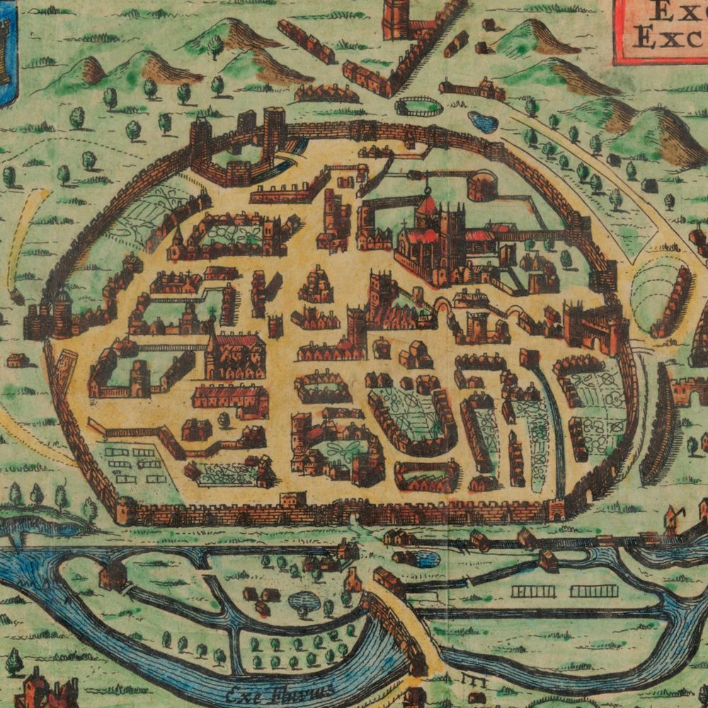
A map of the University and city from 1751, much of it still recognisable today! 🗺️
Shelmark: Bodleian Library, Gough Maps Oxfordshire 12
Shelmark: Bodleian Library, Gough Maps Oxfordshire 12

January 9, 2026 at 3:40 PM
A map of the University and city from 1751, much of it still recognisable today! 🗺️
Shelmark: Bodleian Library, Gough Maps Oxfordshire 12
Shelmark: Bodleian Library, Gough Maps Oxfordshire 12
Reposted by Humap: the digital humanities map platform

Hey everyone who’s overinterested in #defence or #OSINT or just #GIS: do you happen to know any good resources, like datasets, GIS shapefiles, etc etc that could be useful for doing some OSINT exercises about the environs of Finland and the Baltic countries?
OR are you interested in joining forces?
OR are you interested in joining forces?
January 8, 2026 at 11:35 AM

Reposted by Humap: the digital humanities map platform

Historic Environment Scotland are hosting 4 free online events all about 'Making the Case for Archives and Libraries'. Each running on Monday lunchtime from 19th Jan to 9th Feb, and lasting an hour.
Click the link below for more info and to book via Eventbrite:
www.eventbrite.com/cc/making-th...
Click the link below for more info and to book via Eventbrite:
www.eventbrite.com/cc/making-th...
www.eventbrite.com
January 7, 2026 at 9:10 PM
Historic Environment Scotland are hosting 4 free online events all about 'Making the Case for Archives and Libraries'. Each running on Monday lunchtime from 19th Jan to 9th Feb, and lasting an hour.
Click the link below for more info and to book via Eventbrite:
www.eventbrite.com/cc/making-th...
Click the link below for more info and to book via Eventbrite:
www.eventbrite.com/cc/making-th...
Reposted by Humap: the digital humanities map platform

Tickets to attend our online #HMD2026 lecture are now live!
Book via our website 🔗 wienerholocaustlibrary.org/event/holoca...
Book via our website 🔗 wienerholocaustlibrary.org/event/holoca...
January 7, 2026 at 9:21 AM
Tickets to attend our online #HMD2026 lecture are now live!
Book via our website 🔗 wienerholocaustlibrary.org/event/holoca...
Book via our website 🔗 wienerholocaustlibrary.org/event/holoca...
Reposted by Humap: the digital humanities map platform

🚨ONLINE WORKSHOP🚨
We will be hosting a free online workshop “Maximising Data from Palaeolithic Bone" as part of the the COEXIST project on 10th March 2026. Please submit abstract by 23rd January 2026. Further information in the flyer. See you there!
We will be hosting a free online workshop “Maximising Data from Palaeolithic Bone" as part of the the COEXIST project on 10th March 2026. Please submit abstract by 23rd January 2026. Further information in the flyer. See you there!

December 15, 2025 at 9:33 AM
🚨ONLINE WORKSHOP🚨
We will be hosting a free online workshop “Maximising Data from Palaeolithic Bone" as part of the the COEXIST project on 10th March 2026. Please submit abstract by 23rd January 2026. Further information in the flyer. See you there!
We will be hosting a free online workshop “Maximising Data from Palaeolithic Bone" as part of the the COEXIST project on 10th March 2026. Please submit abstract by 23rd January 2026. Further information in the flyer. See you there!
Reposted by Humap: the digital humanities map platform

How's this for a view?
Here's Pen Y Fan, Bannau Brycheiniog (Brecon Beacons) looking sublime after fresh snowfall this week.
Here's Pen Y Fan, Bannau Brycheiniog (Brecon Beacons) looking sublime after fresh snowfall this week.


January 8, 2026 at 8:05 AM
How's this for a view?
Here's Pen Y Fan, Bannau Brycheiniog (Brecon Beacons) looking sublime after fresh snowfall this week.
Here's Pen Y Fan, Bannau Brycheiniog (Brecon Beacons) looking sublime after fresh snowfall this week.
Reposted by Humap: the digital humanities map platform
Want to learn more about SABRE Maps? Not sure which #maps we have available or how to find them? Or what other mapping functions we have? Perhaps you just like maps, history or the railways? Join us for our first-ever Zoom session, Wed 14 Jan 2026 - free at 1930 UK/Ireland time. buff.ly/JxwTeg1

January 8, 2026 at 10:00 AM
Want to learn more about SABRE Maps? Not sure which #maps we have available or how to find them? Or what other mapping functions we have? Perhaps you just like maps, history or the railways? Join us for our first-ever Zoom session, Wed 14 Jan 2026 - free at 1930 UK/Ireland time. buff.ly/JxwTeg1
Reposted by Humap: the digital humanities map platform

The Society is delighted to see that the Clifton Hotel in #Scarborough has been listed at Grade II. Wilfred Owen worked on his World War I war poetry whilst billeted at the hotel during the conflict. He worked from the tower whilst convalescing. Read the excellent list entry here: bit.ly/4jDs9uk


January 8, 2026 at 11:04 AM
The Society is delighted to see that the Clifton Hotel in #Scarborough has been listed at Grade II. Wilfred Owen worked on his World War I war poetry whilst billeted at the hotel during the conflict. He worked from the tower whilst convalescing. Read the excellent list entry here: bit.ly/4jDs9uk
Reposted by Humap: the digital humanities map platform
It's the first #HillfortsWednesday of 2026 !!
Here's a fantastic recreation of the main N gate approach corridor to Tre'r Ceiri #Gwynedd 🤩
© A Smith / @henebtwa.bsky.social
From G Smith *Hillforts and Hut Groups of NW Wales* @intarcheditor.bsky.social 👇👇
intarch.ac.uk/journal/issu...
Here's a fantastic recreation of the main N gate approach corridor to Tre'r Ceiri #Gwynedd 🤩
© A Smith / @henebtwa.bsky.social
From G Smith *Hillforts and Hut Groups of NW Wales* @intarcheditor.bsky.social 👇👇
intarch.ac.uk/journal/issu...

January 7, 2026 at 8:38 AM
It's the first #HillfortsWednesday of 2026 !!
Here's a fantastic recreation of the main N gate approach corridor to Tre'r Ceiri #Gwynedd 🤩
© A Smith / @henebtwa.bsky.social
From G Smith *Hillforts and Hut Groups of NW Wales* @intarcheditor.bsky.social 👇👇
intarch.ac.uk/journal/issu...
Here's a fantastic recreation of the main N gate approach corridor to Tre'r Ceiri #Gwynedd 🤩
© A Smith / @henebtwa.bsky.social
From G Smith *Hillforts and Hut Groups of NW Wales* @intarcheditor.bsky.social 👇👇
intarch.ac.uk/journal/issu...