

Hayden Manka
@haydenmanka.bsky.social
Weather, politics, and spaceflight fan
I also love women. 🔞🔞🔞MINORS AND OTHER STRANGE PEOPLE DNI!!
I also love women. 🔞🔞🔞MINORS AND OTHER STRANGE PEOPLE DNI!!
Reposted by Hayden Manka

Multi-panel view of the last few days of Hurricane Melissa:
↖️ GOES-19 infrared brightness temp
↗️ GOES-19 visible satellite
↙️ Hurricane hunter planes & flight paths
↘️ Recon-derived flight level wind swath
⬇️ Estimated minimum pressure from recon dropsondes
↖️ GOES-19 infrared brightness temp
↗️ GOES-19 visible satellite
↙️ Hurricane hunter planes & flight paths
↘️ Recon-derived flight level wind swath
⬇️ Estimated minimum pressure from recon dropsondes
October 29, 2025 at 10:14 PM
Multi-panel view of the last few days of Hurricane Melissa:
↖️ GOES-19 infrared brightness temp
↗️ GOES-19 visible satellite
↙️ Hurricane hunter planes & flight paths
↘️ Recon-derived flight level wind swath
⬇️ Estimated minimum pressure from recon dropsondes
↖️ GOES-19 infrared brightness temp
↗️ GOES-19 visible satellite
↙️ Hurricane hunter planes & flight paths
↘️ Recon-derived flight level wind swath
⬇️ Estimated minimum pressure from recon dropsondes
Reposted by Hayden Manka

Tomer always makes the best visualizations, but this is up there with the best... an incredible overview of #Melissa's remarkable evolution over the past 5 days.
Multi-panel view of the last few days of Hurricane Melissa:
↖️ GOES-19 infrared brightness temp
↗️ GOES-19 visible satellite
↙️ Hurricane hunter planes & flight paths
↘️ Recon-derived flight level wind swath
⬇️ Estimated minimum pressure from recon dropsondes
↖️ GOES-19 infrared brightness temp
↗️ GOES-19 visible satellite
↙️ Hurricane hunter planes & flight paths
↘️ Recon-derived flight level wind swath
⬇️ Estimated minimum pressure from recon dropsondes
October 30, 2025 at 2:40 AM
Tomer always makes the best visualizations, but this is up there with the best... an incredible overview of #Melissa's remarkable evolution over the past 5 days.
Reposted by Hayden Manka
Given higher than usual confidence of rapid intensification (RI) from analyses of an exceptionally favorable environment & with the aid of newer hurricane models (HAFS) & Google DeepMind, NHC was able to skillfully predict Melissa's RI days in advance.

October 29, 2025 at 12:18 AM
Given higher than usual confidence of rapid intensification (RI) from analyses of an exceptionally favorable environment & with the aid of newer hurricane models (HAFS) & Google DeepMind, NHC was able to skillfully predict Melissa's RI days in advance.
Reposted by Hayden Manka
Annotating a long 3+ day loop of #Hurricane #Melissa from Kingston, #Jamaica radar.
2️⃣ periods appear where an eyewall replacement cycle, #ERC, looked underway. In both cases, inner eyewall stayed intact & outer bands merged, resulting in a larger eye & strengthening after.
A remarkable evolution 🌀
2️⃣ periods appear where an eyewall replacement cycle, #ERC, looked underway. In both cases, inner eyewall stayed intact & outer bands merged, resulting in a larger eye & strengthening after.
A remarkable evolution 🌀
October 30, 2025 at 6:54 AM
Annotating a long 3+ day loop of #Hurricane #Melissa from Kingston, #Jamaica radar.
2️⃣ periods appear where an eyewall replacement cycle, #ERC, looked underway. In both cases, inner eyewall stayed intact & outer bands merged, resulting in a larger eye & strengthening after.
A remarkable evolution 🌀
2️⃣ periods appear where an eyewall replacement cycle, #ERC, looked underway. In both cases, inner eyewall stayed intact & outer bands merged, resulting in a larger eye & strengthening after.
A remarkable evolution 🌀
Reposted by Hayden Manka

Hurricane Melissa’s historic journey to becoming one of the most intense tropical cyclones ever recorded on Earth.
A storm we won't forget anytime soon.
A storm we won't forget anytime soon.
October 29, 2025 at 1:49 PM
Hurricane Melissa’s historic journey to becoming one of the most intense tropical cyclones ever recorded on Earth.
A storm we won't forget anytime soon.
A storm we won't forget anytime soon.
Reposted by Hayden Manka

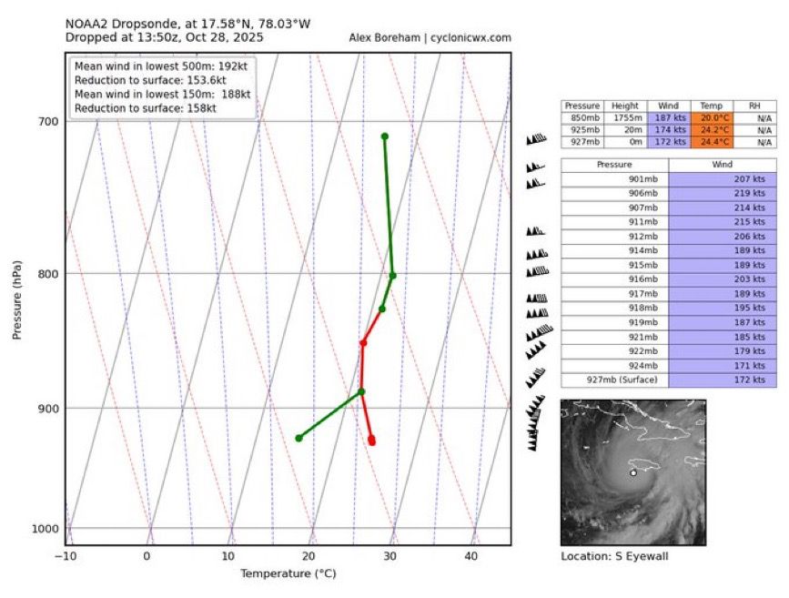
Wow. This is easily the most ridiculous dropsonde I’ve ever seen.
188 knot mean winds in the low-levels with gusts over 250 mph
Absolutely scary and historic hurricane headed into SW Jamaica this morning
188 knot mean winds in the low-levels with gusts over 250 mph
Absolutely scary and historic hurricane headed into SW Jamaica this morning
October 28, 2025 at 2:21 PM
Wow. This is easily the most ridiculous dropsonde I’ve ever seen.
188 knot mean winds in the low-levels with gusts over 250 mph
Absolutely scary and historic hurricane headed into SW Jamaica this morning
188 knot mean winds in the low-levels with gusts over 250 mph
Absolutely scary and historic hurricane headed into SW Jamaica this morning
Reposted by Hayden Manka

animal crossing was better when the villagers were genuinely rude
October 27, 2025 at 12:14 AM
animal crossing was better when the villagers were genuinely rude
Reposted by Hayden Manka

SAMI ventures out of her cave one last time before winter... 🍑💦💞
More: www.patreon.com/c/whisperfoot
More: www.patreon.com/c/whisperfoot

October 27, 2025 at 6:18 PM
SAMI ventures out of her cave one last time before winter... 🍑💦💞
More: www.patreon.com/c/whisperfoot
More: www.patreon.com/c/whisperfoot
Reposted by Hayden Manka


October 27, 2025 at 6:21 PM
Reposted by Hayden Manka

The 2pm ET public update advisory for Hurricane Melissa has the central pressure down to 906 mb with peak winds of 175 mph. This makes Melissa the 10th strongest hurricane in record in the Atlantic Basin.

October 27, 2025 at 6:25 PM
The 2pm ET public update advisory for Hurricane Melissa has the central pressure down to 906 mb with peak winds of 175 mph. This makes Melissa the 10th strongest hurricane in record in the Atlantic Basin.
Reposted by Hayden Manka
Just a follow up to say this did end up verifying:
AT 5pm Oct 25th, #Melissa was at 16.6N 75.5W.
By 11pm Oct 26th, #Melissa was at 16.3N 77.7W.
Just enough S of due W motion to delay serious rainfall hazards in #Jamaica temporary, though onset of catastrophic rainfall impacts likely today.
AT 5pm Oct 25th, #Melissa was at 16.6N 75.5W.
By 11pm Oct 26th, #Melissa was at 16.3N 77.7W.
Just enough S of due W motion to delay serious rainfall hazards in #Jamaica temporary, though onset of catastrophic rainfall impacts likely today.


October 27, 2025 at 5:20 PM
Reposted by Hayden Manka

I am at a loss for words as I watch Hurricane Melissa continue intensifying today. I'm thinking of the many folks in its path who will face compound flooding and wind hazards over an extended period of time.
(Animation shows 1-minute GOES mesoscale imagery since sunrise on October 27.)
(Animation shows 1-minute GOES mesoscale imagery since sunrise on October 27.)
October 27, 2025 at 5:55 PM
I am at a loss for words as I watch Hurricane Melissa continue intensifying today. I'm thinking of the many folks in its path who will face compound flooding and wind hazards over an extended period of time.
(Animation shows 1-minute GOES mesoscale imagery since sunrise on October 27.)
(Animation shows 1-minute GOES mesoscale imagery since sunrise on October 27.)
Reposted by Hayden Manka

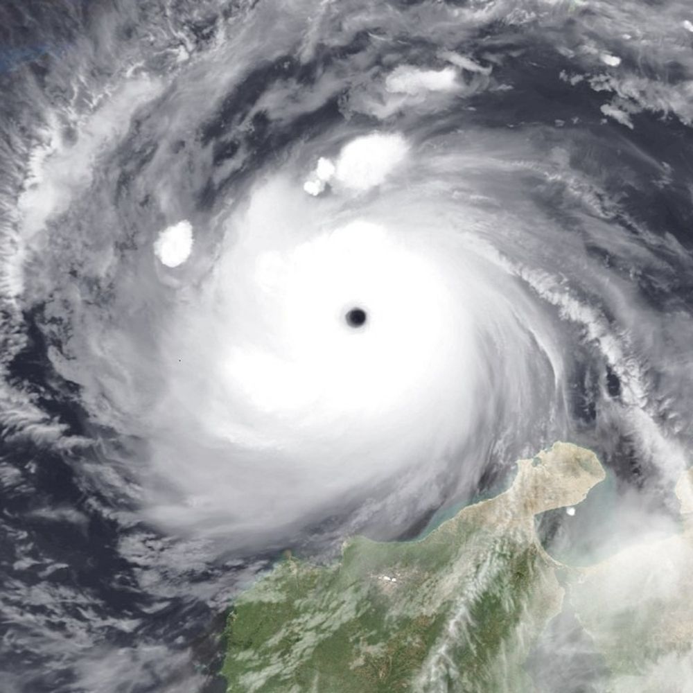
From a crewmember on yesterday's Teal 74 mission into now-Category 5 Hurricane #Melissa. As clear of an eye as you will see in the Atlantic basin.
October 27, 2025 at 4:11 PM
From a crewmember on yesterday's Teal 74 mission into now-Category 5 Hurricane #Melissa. As clear of an eye as you will see in the Atlantic basin.
Reposted by Hayden Manka

Happy birthday!! @gammainks.bsky.social 🎂🥳
Drew your adorable Vulpix girl Alice~ Hope you like her!!❤️
Drew your adorable Vulpix girl Alice~ Hope you like her!!❤️

October 26, 2025 at 8:51 PM
Happy birthday!! @gammainks.bsky.social 🎂🥳
Drew your adorable Vulpix girl Alice~ Hope you like her!!❤️
Drew your adorable Vulpix girl Alice~ Hope you like her!!❤️
Reposted by Hayden Manka

NOAA tail Doppler radar data also shows an eye forming and the vortex tilt, which was still large last night, has decreased substantially. More signs that indicate Melissa is poised to make a sprint in its intensity.

October 25, 2025 at 12:27 PM
NOAA tail Doppler radar data also shows an eye forming and the vortex tilt, which was still large last night, has decreased substantially. More signs that indicate Melissa is poised to make a sprint in its intensity.
Reposted by Hayden Manka
Hurricane Hunter data show Melissa is near hurricane status and has developed a more sharply peaked wind maximum near the center, especially SW, which was previously the weaker side. With this sharpening and deep convection wrapping upshear, intensification should be much more rapid going forward.

October 25, 2025 at 12:17 PM
Hurricane Hunter data show Melissa is near hurricane status and has developed a more sharply peaked wind maximum near the center, especially SW, which was previously the weaker side. With this sharpening and deep convection wrapping upshear, intensification should be much more rapid going forward.
Reposted by Hayden Manka
Looks like Melissa is ready to hit the loud pedal. Satellite presentation has improved markedly since yesterday. Hurricane Hunters reporting measurements supporting (near) hurricane strength and an (almost) closed eyewall. Mw images from this morning already showed that nascent core.


October 25, 2025 at 2:11 PM
Looks like Melissa is ready to hit the loud pedal. Satellite presentation has improved markedly since yesterday. Hurricane Hunters reporting measurements supporting (near) hurricane strength and an (almost) closed eyewall. Mw images from this morning already showed that nascent core.
Reposted by Hayden Manka

The sun has risen over #Melissa which is likely a #hurricane at this point, thanks to recon. The storm has a decently sized eyewall, which will allow for it to RAPIDLY INTENSIFY when shear lowers. Rainfall totals of OVER 30 INCHES are now being forecasted for #Jamaica!


October 25, 2025 at 2:30 PM
The sun has risen over #Melissa which is likely a #hurricane at this point, thanks to recon. The storm has a decently sized eyewall, which will allow for it to RAPIDLY INTENSIFY when shear lowers. Rainfall totals of OVER 30 INCHES are now being forecasted for #Jamaica!
Reposted by Hayden Manka

I created this animation of surface wind & pressure from 10-second output from the WRF model using one of our many simulations of the storm.
Notice how dramatically the wind speed decreases over land due to friction. Also pay attention to lower wind speeds over the #Miami metro area.
#Wilma20
[4/6]
Notice how dramatically the wind speed decreases over land due to friction. Also pay attention to lower wind speeds over the #Miami metro area.
#Wilma20
[4/6]
October 23, 2025 at 6:31 PM
Reposted by Hayden Manka
Jill knows how to motivate.. people, to do chores. ;p Which version do you like more, nude apron or fully nude~?
Posted previously on www.patreon.com/alfa995 ❤️
Posted previously on www.patreon.com/alfa995 ❤️


October 23, 2025 at 11:49 PM
Jill knows how to motivate.. people, to do chores. ;p Which version do you like more, nude apron or fully nude~?
Posted previously on www.patreon.com/alfa995 ❤️
Posted previously on www.patreon.com/alfa995 ❤️


Reposted by Hayden Manka
I think it's harder when Doe is around~! >>
Alt on https://www.patreon.com/alfa995 !
Alt on https://www.patreon.com/alfa995 !

October 12, 2025 at 11:22 PM
I think it's harder when Doe is around~! >>
Alt on https://www.patreon.com/alfa995 !
Alt on https://www.patreon.com/alfa995 !
Reposted by Hayden Manka
Hadn't payed much attention to Jerry as an Invest. When I checked it out today I immediately noticed the good outflow pattern aloft on satellite imagery. Cirrus streaning off in all direcitons. Undoubtedly very helfpul as the system struggles with brisk low-level easterlies.
October 7, 2025 at 6:22 PM
Hadn't payed much attention to Jerry as an Invest. When I checked it out today I immediately noticed the good outflow pattern aloft on satellite imagery. Cirrus streaning off in all direcitons. Undoubtedly very helfpul as the system struggles with brisk low-level easterlies.
Reposted by Hayden Manka
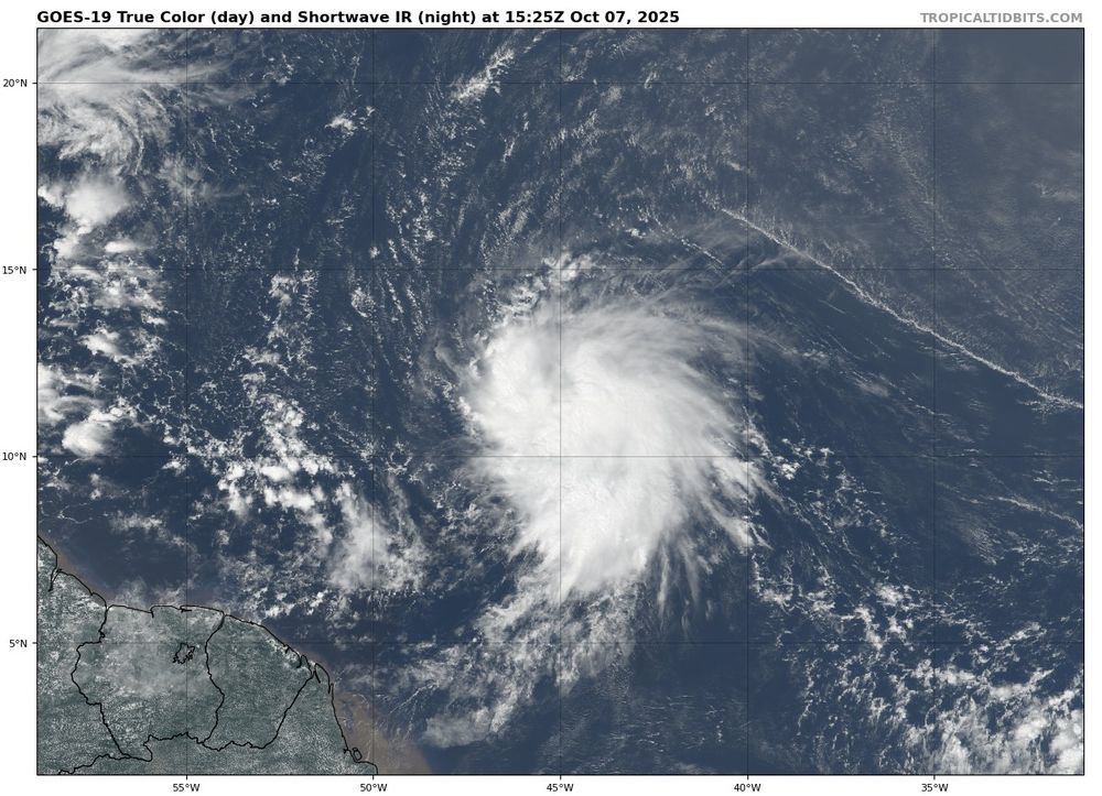
Thanks to a recent ASCAT pass, we now have Tropical Storm #Jerry in the North Atlantic with winds of around 40kts. The system is expected to peak as a Category 1-2 #hurricane near the Leeward Islands. If you live there, this system is definitely worth watching!
#wx
#wx


October 7, 2025 at 3:43 PM
Thanks to a recent ASCAT pass, we now have Tropical Storm #Jerry in the North Atlantic with winds of around 40kts. The system is expected to peak as a Category 1-2 #hurricane near the Leeward Islands. If you live there, this system is definitely worth watching!
#wx
#wx
Reposted by Hayden Manka