


Derek Law
@gisbandit.bsky.social
Product Manager at Esri | Interests #GIS, #HealthGIS, #Maps, #DataViz
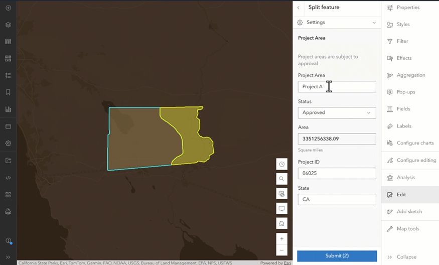
New #Editing Tools in the #ArcGISOnline #Map Viewer tinyurl.com/4827zw7v
#DataMgmt #GIS #esri #arcgis #mapping #maps #GISchat #geospatial #TheScienceOfWhere #geosky
#DataMgmt #GIS #esri #arcgis #mapping #maps #GISchat #geospatial #TheScienceOfWhere #geosky
November 10, 2025 at 2:30 PM
New #Editing Tools in the #ArcGISOnline #Map Viewer tinyurl.com/4827zw7v
#DataMgmt #GIS #esri #arcgis #mapping #maps #GISchat #geospatial #TheScienceOfWhere #geosky
#DataMgmt #GIS #esri #arcgis #mapping #maps #GISchat #geospatial #TheScienceOfWhere #geosky
Reposted by Derek Law

For our next map for the #30DayMapChallenge, for Day 3's prompt "Polygons", we made a quick map of Burlington, Vermont!

November 9, 2025 at 8:28 PM
For our next map for the #30DayMapChallenge, for Day 3's prompt "Polygons", we made a quick map of Burlington, Vermont!
Reposted by Derek Law

Day 9 of the #30DayMapChallenge - Analog. Create your map using traditional methods. Obviously I am not going to stick to this. Frankly nothing is more traditional that Python so here is another map made with Python. Roads of the Roman Empire.

November 9, 2025 at 6:05 PM
Day 9 of the #30DayMapChallenge - Analog. Create your map using traditional methods. Obviously I am not going to stick to this. Frankly nothing is more traditional that Python so here is another map made with Python. Roads of the Roman Empire.
Reposted by Derek Law
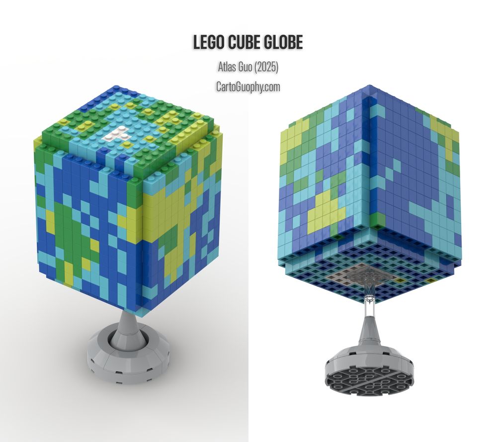
#30DayMapChallenge Day 5&6 I just completed my first #globe design, a virtually rendered #LEGO cube globe! The colors were derived from a pixelated Natural Earth raster layer (Cube Projection). As usual, I applied manual cartographic curation to preserve recognizable geography. Hope you enjoy it!
November 9, 2025 at 5:00 AM
#30DayMapChallenge Day 5&6 I just completed my first #globe design, a virtually rendered #LEGO cube globe! The colors were derived from a pixelated Natural Earth raster layer (Cube Projection). As usual, I applied manual cartographic curation to preserve recognizable geography. Hope you enjoy it!
Reposted by Derek Law

Nothing like a nice long flight for catching up on #30DayMapChallenge 🤪.
Here's Day 8 — urban — right on time. A map of Paris buildings by age of construction. A real beauty if I do say so myself. 😍
Here's Day 8 — urban — right on time. A map of Paris buildings by age of construction. A real beauty if I do say so myself. 😍

November 9, 2025 at 12:53 AM
Nothing like a nice long flight for catching up on #30DayMapChallenge 🤪.
Here's Day 8 — urban — right on time. A map of Paris buildings by age of construction. A real beauty if I do say so myself. 😍
Here's Day 8 — urban — right on time. A map of Paris buildings by age of construction. A real beauty if I do say so myself. 😍
Reposted by Derek Law

Map of Greek mythology.
🔎 Hazel Newlevant
🔎 Hazel Newlevant

November 8, 2025 at 7:11 AM
Map of Greek mythology.
🔎 Hazel Newlevant
🔎 Hazel Newlevant
Reposted by Derek Law

#30DayMapChallenge Accessibility
Edinburgh is a wonderful city. And it is generally accessible, however as with any city, some parts are more accessible than others. This map uses data from ArcGIS Online to show the accessibility score by postal codes.
Source data:
lnkd.in/gyktNmzv
Edinburgh is a wonderful city. And it is generally accessible, however as with any city, some parts are more accessible than others. This map uses data from ArcGIS Online to show the accessibility score by postal codes.
Source data:
lnkd.in/gyktNmzv

November 7, 2025 at 10:08 PM
#30DayMapChallenge Accessibility
Edinburgh is a wonderful city. And it is generally accessible, however as with any city, some parts are more accessible than others. This map uses data from ArcGIS Online to show the accessibility score by postal codes.
Source data:
lnkd.in/gyktNmzv
Edinburgh is a wonderful city. And it is generally accessible, however as with any city, some parts are more accessible than others. This map uses data from ArcGIS Online to show the accessibility score by postal codes.
Source data:
lnkd.in/gyktNmzv
Reposted by Derek Law
📈 U.S. state economies that have grown the most since 1998.

November 8, 2025 at 1:08 AM
📈 U.S. state economies that have grown the most since 1998.
In 1 week, #Esri webinar: #ArcGIS QuickCapture - Advanced Project Design to #Optimize Field #Data Capture tinyurl.com/2dhu7jx4
#mobile #GIS #fieldwork #DataCollection #mapping #maps #ArcGISApps #GISchat #geospatial #TheScienceOfWhere #geosky
#mobile #GIS #fieldwork #DataCollection #mapping #maps #ArcGISApps #GISchat #geospatial #TheScienceOfWhere #geosky

November 7, 2025 at 3:02 PM
In 1 week, #Esri webinar: #ArcGIS QuickCapture - Advanced Project Design to #Optimize Field #Data Capture tinyurl.com/2dhu7jx4
#mobile #GIS #fieldwork #DataCollection #mapping #maps #ArcGISApps #GISchat #geospatial #TheScienceOfWhere #geosky
#mobile #GIS #fieldwork #DataCollection #mapping #maps #ArcGISApps #GISchat #geospatial #TheScienceOfWhere #geosky
Reposted by Derek Law

#30DayMapChallenge
Day 7: Accessibility
Today's map answers the question: How far can you get in Brussels, in an hour?
Starting point: Manneken Pis!
Data from TravelTime API and OpenStreetMap.
Day 7: Accessibility
Today's map answers the question: How far can you get in Brussels, in an hour?
Starting point: Manneken Pis!
Data from TravelTime API and OpenStreetMap.

November 7, 2025 at 12:46 PM
#30DayMapChallenge
Day 7: Accessibility
Today's map answers the question: How far can you get in Brussels, in an hour?
Starting point: Manneken Pis!
Data from TravelTime API and OpenStreetMap.
Day 7: Accessibility
Today's map answers the question: How far can you get in Brussels, in an hour?
Starting point: Manneken Pis!
Data from TravelTime API and OpenStreetMap.
Reposted by Derek Law

Mapamundi de la pesca y la acuicultura (2023): https://mapasmilhaud.com/mapas-de-datos/mapamundi-de-la-pesca-y-la-acuicultura-2023/
#Mapas #Maps
#Mapas #Maps

November 7, 2025 at 7:02 AM
Mapamundi de la pesca y la acuicultura (2023): https://mapasmilhaud.com/mapas-de-datos/mapamundi-de-la-pesca-y-la-acuicultura-2023/
#Mapas #Maps
#Mapas #Maps
Reposted by Derek Law

🚇 Paris en toute autonomie : accessibilité du métro
🌍 #30DayMapChallenge – Jour 7 : Accessibilité
Pour ce septième jour, cap sur Paris et son réseau de métro.
Données : Île-de-France Mobilités, RATP, Open Data Paris, BD Topo® (IGN)
#ArcGIS
🌍 #30DayMapChallenge – Jour 7 : Accessibilité
Pour ce septième jour, cap sur Paris et son réseau de métro.
Données : Île-de-France Mobilités, RATP, Open Data Paris, BD Topo® (IGN)
#ArcGIS

November 7, 2025 at 7:07 AM
🚇 Paris en toute autonomie : accessibilité du métro
🌍 #30DayMapChallenge – Jour 7 : Accessibilité
Pour ce septième jour, cap sur Paris et son réseau de métro.
Données : Île-de-France Mobilités, RATP, Open Data Paris, BD Topo® (IGN)
#ArcGIS
🌍 #30DayMapChallenge – Jour 7 : Accessibilité
Pour ce septième jour, cap sur Paris et son réseau de métro.
Données : Île-de-France Mobilités, RATP, Open Data Paris, BD Topo® (IGN)
#ArcGIS
Reposted by Derek Law

A little bit of #ggplot2 and #rayshader for the "dimensions" prompt on day 6 of the #30DayMapChallenge! 🌧️
#RStats #DataViz
#RStats #DataViz

November 6, 2025 at 11:43 PM
A little bit of #ggplot2 and #rayshader for the "dimensions" prompt on day 6 of the #30DayMapChallenge! 🌧️
#RStats #DataViz
#RStats #DataViz
Reposted by Derek Law
The Sturgeon River, Michigan, USA, cutting through glacial deposits with dunes on top.

November 6, 2025 at 9:51 PM
The Sturgeon River, Michigan, USA, cutting through glacial deposits with dunes on top.
Reposted by Derek Law
A one world ocean.

November 5, 2025 at 7:13 PM
A one world ocean.
What's New in #ArcGIS Experience Builder (Oct 2025) tinyurl.com/ys34cabp
#apps #mapping #dataviz #GIS #esri #ArcGISApps #maps #GISchat #geospatial #TheScienceOfWhere #geosky
#apps #mapping #dataviz #GIS #esri #ArcGISApps #maps #GISchat #geospatial #TheScienceOfWhere #geosky

November 6, 2025 at 1:37 PM
What's New in #ArcGIS Experience Builder (Oct 2025) tinyurl.com/ys34cabp
#apps #mapping #dataviz #GIS #esri #ArcGISApps #maps #GISchat #geospatial #TheScienceOfWhere #geosky
#apps #mapping #dataviz #GIS #esri #ArcGISApps #maps #GISchat #geospatial #TheScienceOfWhere #geosky
Reposted by Derek Law

#GeographyAwarenessWeek is coming November 17-21 and we’re proud to partner with our sponsors Esri and the National Council for Geographic Education this year to celebrate "Making Spaces of Possibility.”
Hosting an event? Check out the #GeoWeek2025 StoryMap and get involved: buff.ly/ohFkOQp
Hosting an event? Check out the #GeoWeek2025 StoryMap and get involved: buff.ly/ohFkOQp

November 6, 2025 at 12:45 PM
#GeographyAwarenessWeek is coming November 17-21 and we’re proud to partner with our sponsors Esri and the National Council for Geographic Education this year to celebrate "Making Spaces of Possibility.”
Hosting an event? Check out the #GeoWeek2025 StoryMap and get involved: buff.ly/ohFkOQp
Hosting an event? Check out the #GeoWeek2025 StoryMap and get involved: buff.ly/ohFkOQp
Reposted by Derek Law

In addition to the 50K maps, BGS has also updated its 10K & 25K maps. BGS Geology 10K and 25K is the most detailed geological dataset we have produced. Around half of the country is now covered with this update, including many urban centres.
www.bgs.ac.uk/news/latest-...
www.bgs.ac.uk/news/latest-...

Latest BGS Geology 50K mapping data launched - British Geological Survey
Some of our most widely used maps have received a major update, including the 1:50 000-scale map series that now includes enhanced coverage of Great Britain.
www.bgs.ac.uk
November 6, 2025 at 12:35 PM
In addition to the 50K maps, BGS has also updated its 10K & 25K maps. BGS Geology 10K and 25K is the most detailed geological dataset we have produced. Around half of the country is now covered with this update, including many urban centres.
www.bgs.ac.uk/news/latest-...
www.bgs.ac.uk/news/latest-...
Reposted by Derek Law


November 6, 2025 at 10:01 AM
Reposted by Derek Law

#30DayMapChallenge 🗺️ Day 5️⃣: Earth
Here’s a minimal isometric relief map of Santorini. I haven’t been to #Greece 🇬🇷 but I definitely want to see Athens, and either Santorini or Mykonos. Maybe I hope that by creating this map I can manifest that trip? 😁
Digital elevation model data is from NASADEM.
Here’s a minimal isometric relief map of Santorini. I haven’t been to #Greece 🇬🇷 but I definitely want to see Athens, and either Santorini or Mykonos. Maybe I hope that by creating this map I can manifest that trip? 😁
Digital elevation model data is from NASADEM.

November 6, 2025 at 9:07 AM
#30DayMapChallenge 🗺️ Day 5️⃣: Earth
Here’s a minimal isometric relief map of Santorini. I haven’t been to #Greece 🇬🇷 but I definitely want to see Athens, and either Santorini or Mykonos. Maybe I hope that by creating this map I can manifest that trip? 😁
Digital elevation model data is from NASADEM.
Here’s a minimal isometric relief map of Santorini. I haven’t been to #Greece 🇬🇷 but I definitely want to see Athens, and either Santorini or Mykonos. Maybe I hope that by creating this map I can manifest that trip? 😁
Digital elevation model data is from NASADEM.
Reposted by Derek Law

The prompt for day 5 of the #30DayMapChallenge was 'Earth' so I tried to plot the elevation of the Kananaskis Valley!

November 6, 2025 at 4:19 AM
The prompt for day 5 of the #30DayMapChallenge was 'Earth' so I tried to plot the elevation of the Kananaskis Valley!
Reposted by Derek Law
🌲 Which countries have the largest forests?

November 4, 2025 at 5:11 PM
🌲 Which countries have the largest forests?
#ArcGISMonitor user success story featuring #Dallas #Police Department rb.gy/276pbn
#ArcGISEnterprise #observability #systemhealth #performance #WebGIS #GIS #esri #arcgis #GISchat #geospatial #IT #TheScienceOfWhere #geosky
#ArcGISEnterprise #observability #systemhealth #performance #WebGIS #GIS #esri #arcgis #GISchat #geospatial #IT #TheScienceOfWhere #geosky

November 5, 2025 at 2:24 PM
#ArcGISMonitor user success story featuring #Dallas #Police Department rb.gy/276pbn
#ArcGISEnterprise #observability #systemhealth #performance #WebGIS #GIS #esri #arcgis #GISchat #geospatial #IT #TheScienceOfWhere #geosky
#ArcGISEnterprise #observability #systemhealth #performance #WebGIS #GIS #esri #arcgis #GISchat #geospatial #IT #TheScienceOfWhere #geosky
Reposted by Derek Law

⛷️ Paris est transformée en station de ski, avec ses pistes et ses remontées mécaniques ! Bienvenue au domaine Paris 130 🤩
#30DayMapChallenge – J5 #Earth
✍️ Vincent Héau
📊 MNT LiDAR HD IGN
Découvrir toutes les cartes de nos agents : www.ign.fr/mag/30DayMap...
#30DayMapChallenge – J5 #Earth
✍️ Vincent Héau
📊 MNT LiDAR HD IGN
Découvrir toutes les cartes de nos agents : www.ign.fr/mag/30DayMap...


November 5, 2025 at 1:25 PM
⛷️ Paris est transformée en station de ski, avec ses pistes et ses remontées mécaniques ! Bienvenue au domaine Paris 130 🤩
#30DayMapChallenge – J5 #Earth
✍️ Vincent Héau
📊 MNT LiDAR HD IGN
Découvrir toutes les cartes de nos agents : www.ign.fr/mag/30DayMap...
#30DayMapChallenge – J5 #Earth
✍️ Vincent Héau
📊 MNT LiDAR HD IGN
Découvrir toutes les cartes de nos agents : www.ign.fr/mag/30DayMap...
Reposted by Derek Law
#30DayMapChallenge Day 5: Earth
Here's a map of the tree canopy in Idaho!
Here's a map of the tree canopy in Idaho!

November 5, 2025 at 12:51 PM
#30DayMapChallenge Day 5: Earth
Here's a map of the tree canopy in Idaho!
Here's a map of the tree canopy in Idaho!