


British Geological Survey
@bgs.ac.uk
A world-leading independent research organisation providing objective, expert geoscientific data, information and knowledge 🌎
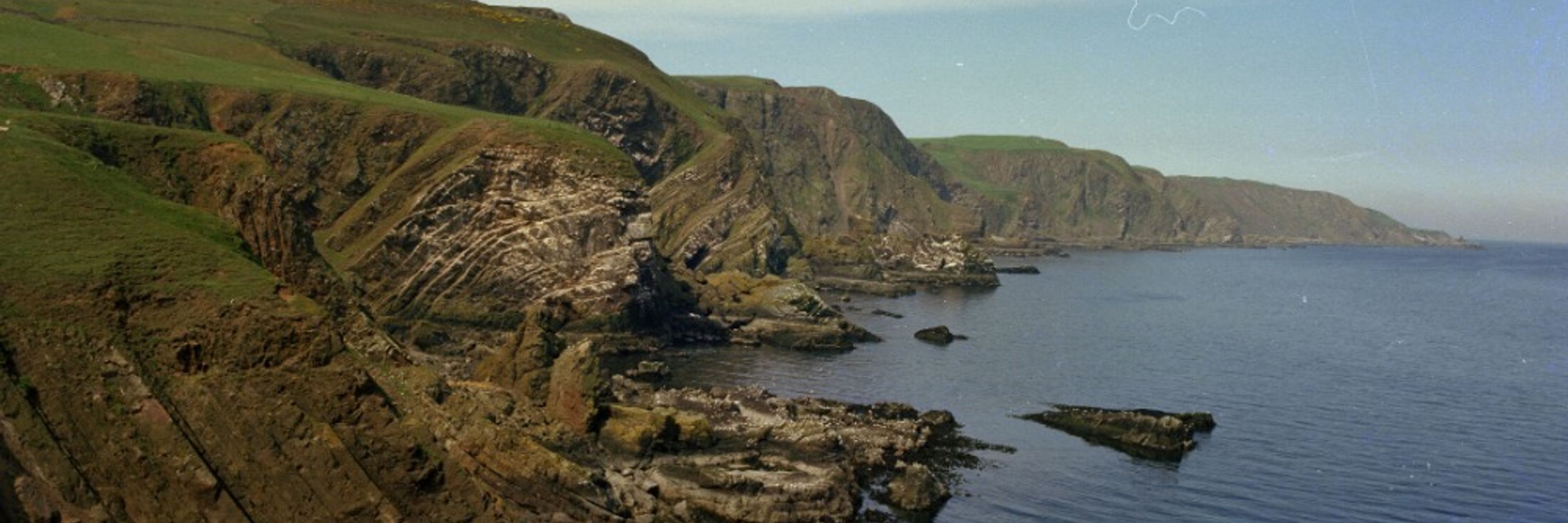
Cliffs might seem strong and safe but they can provide many hazards. Storms, prolonged periods of wet weather, cold snaps and heatwaves can trigger landslides.
Check the image below to see if you can spot the cliff-based hazards in this scene. Answers here: www.bgs.ac.uk/discovering-...
Check the image below to see if you can spot the cliff-based hazards in this scene. Answers here: www.bgs.ac.uk/discovering-...

February 8, 2026 at 10:00 AM
Cliffs might seem strong and safe but they can provide many hazards. Storms, prolonged periods of wet weather, cold snaps and heatwaves can trigger landslides.
Check the image below to see if you can spot the cliff-based hazards in this scene. Answers here: www.bgs.ac.uk/discovering-...
Check the image below to see if you can spot the cliff-based hazards in this scene. Answers here: www.bgs.ac.uk/discovering-...
Did you know that Olympic curling stones come from just one tiny island in Scotland?
Granite from Ailsa Craig has been used to make Olympic curling stones since 1924. Below, you can see a thin section in cross polarised light.
Learn about the stones: britgeoheritage.blogspot.com/2014/02/gran...
Granite from Ailsa Craig has been used to make Olympic curling stones since 1924. Below, you can see a thin section in cross polarised light.
Learn about the stones: britgeoheritage.blogspot.com/2014/02/gran...


February 4, 2026 at 6:01 PM
Did you know that Olympic curling stones come from just one tiny island in Scotland?
Granite from Ailsa Craig has been used to make Olympic curling stones since 1924. Below, you can see a thin section in cross polarised light.
Learn about the stones: britgeoheritage.blogspot.com/2014/02/gran...
Granite from Ailsa Craig has been used to make Olympic curling stones since 1924. Below, you can see a thin section in cross polarised light.
Learn about the stones: britgeoheritage.blogspot.com/2014/02/gran...
Can sandstones under the North Sea unlock the UK’s carbon storage potential?
The Central North Sea represents around 60% of the UK's theoretical carbon storage capacity, yet of the licenced capacity, less than 5% is located there.
www.bgs.ac.uk/news/can-san...
The Central North Sea represents around 60% of the UK's theoretical carbon storage capacity, yet of the licenced capacity, less than 5% is located there.
www.bgs.ac.uk/news/can-san...

February 2, 2026 at 10:25 AM
Can sandstones under the North Sea unlock the UK’s carbon storage potential?
The Central North Sea represents around 60% of the UK's theoretical carbon storage capacity, yet of the licenced capacity, less than 5% is located there.
www.bgs.ac.uk/news/can-san...
The Central North Sea represents around 60% of the UK's theoretical carbon storage capacity, yet of the licenced capacity, less than 5% is located there.
www.bgs.ac.uk/news/can-san...
We're looking for an experienced contracts manager to provide expert legal knowledge to support our commercial research activity and help facilitate major geoscientific research. You'll be based at our Nottinghamshire HQ.
Apply here:
fa-evzn-saasfaukgovprod1.fa.ocs.oraclecloud.com/hcmUI/Candid...
Apply here:
fa-evzn-saasfaukgovprod1.fa.ocs.oraclecloud.com/hcmUI/Candid...

January 31, 2026 at 10:00 AM
We're looking for an experienced contracts manager to provide expert legal knowledge to support our commercial research activity and help facilitate major geoscientific research. You'll be based at our Nottinghamshire HQ.
Apply here:
fa-evzn-saasfaukgovprod1.fa.ocs.oraclecloud.com/hcmUI/Candid...
Apply here:
fa-evzn-saasfaukgovprod1.fa.ocs.oraclecloud.com/hcmUI/Candid...
BGS have launched a premium range of mounted display maps, for customers in search of a quality display piece.
You can select from the national coverage maps, or for more detailed geological info you can request from the 1:50 000 & 1:25 000 scale regional flat maps.
shop.bgs.ac.uk/Shop/Categor...
You can select from the national coverage maps, or for more detailed geological info you can request from the 1:50 000 & 1:25 000 scale regional flat maps.
shop.bgs.ac.uk/Shop/Categor...


January 31, 2026 at 10:00 AM
BGS have launched a premium range of mounted display maps, for customers in search of a quality display piece.
You can select from the national coverage maps, or for more detailed geological info you can request from the 1:50 000 & 1:25 000 scale regional flat maps.
shop.bgs.ac.uk/Shop/Categor...
You can select from the national coverage maps, or for more detailed geological info you can request from the 1:50 000 & 1:25 000 scale regional flat maps.
shop.bgs.ac.uk/Shop/Categor...
Sand is the most valuable commodity on earth, however it faces huge legal and environmental challenges.
On 18 March, join us at @geolsoc.bsky.social as we explore the huge global challenge of sand mining.
Sign up for the event here:
www.eventbrite.co.uk/e/sands-of-c...
On 18 March, join us at @geolsoc.bsky.social as we explore the huge global challenge of sand mining.
Sign up for the event here:
www.eventbrite.co.uk/e/sands-of-c...

January 30, 2026 at 8:01 AM
Sand is the most valuable commodity on earth, however it faces huge legal and environmental challenges.
On 18 March, join us at @geolsoc.bsky.social as we explore the huge global challenge of sand mining.
Sign up for the event here:
www.eventbrite.co.uk/e/sands-of-c...
On 18 March, join us at @geolsoc.bsky.social as we explore the huge global challenge of sand mining.
Sign up for the event here:
www.eventbrite.co.uk/e/sands-of-c...
This March we're holding another Primary Teacher CPD session at our Nottinghamshire HQ.
The free session will guide you through everything you need to know to teach rocks, fossils and soils to your KS2 classes.
Places are limited so book early!
www.eventbrite.co.uk/e/primary-sc...
The free session will guide you through everything you need to know to teach rocks, fossils and soils to your KS2 classes.
Places are limited so book early!
www.eventbrite.co.uk/e/primary-sc...

January 28, 2026 at 3:45 PM
This March we're holding another Primary Teacher CPD session at our Nottinghamshire HQ.
The free session will guide you through everything you need to know to teach rocks, fossils and soils to your KS2 classes.
Places are limited so book early!
www.eventbrite.co.uk/e/primary-sc...
The free session will guide you through everything you need to know to teach rocks, fossils and soils to your KS2 classes.
Places are limited so book early!
www.eventbrite.co.uk/e/primary-sc...
Former non-coal mine workings, particularly where shallow, may collapse and cause & cause surface settlement.
The mining hazard (not coal) dataset provides a subsidence hazard assessment for those looking to identify & mitigate potential ground instability hazards.
www.bgs.ac.uk/datasets/min...
The mining hazard (not coal) dataset provides a subsidence hazard assessment for those looking to identify & mitigate potential ground instability hazards.
www.bgs.ac.uk/datasets/min...

January 27, 2026 at 8:01 AM
Former non-coal mine workings, particularly where shallow, may collapse and cause & cause surface settlement.
The mining hazard (not coal) dataset provides a subsidence hazard assessment for those looking to identify & mitigate potential ground instability hazards.
www.bgs.ac.uk/datasets/min...
The mining hazard (not coal) dataset provides a subsidence hazard assessment for those looking to identify & mitigate potential ground instability hazards.
www.bgs.ac.uk/datasets/min...
Did you see the Aurora displays this week? If so we'd love to see your photos! Thanks to Karl Thurlow for sharing these images with us, taken in Aviemore on Tuesday.
Did you know BGS monitor geomagnetic activity and have an alert service? please visit:
geomag.bgs.ac.uk/education/cu...
Did you know BGS monitor geomagnetic activity and have an alert service? please visit:
geomag.bgs.ac.uk/education/cu...

January 25, 2026 at 10:45 AM
Did you see the Aurora displays this week? If so we'd love to see your photos! Thanks to Karl Thurlow for sharing these images with us, taken in Aviemore on Tuesday.
Did you know BGS monitor geomagnetic activity and have an alert service? please visit:
geomag.bgs.ac.uk/education/cu...
Did you know BGS monitor geomagnetic activity and have an alert service? please visit:
geomag.bgs.ac.uk/education/cu...
Dr Kathryn Goodenough is a Principal Geologist and International Lead at BGS in Edinburgh, where she has worked since 2001.
Her work focuses around the geology, resources and wider supply chains of critical raw materials that are essential for the energy transition.
Her work focuses around the geology, resources and wider supply chains of critical raw materials that are essential for the energy transition.
January 24, 2026 at 12:31 PM
Dr Kathryn Goodenough is a Principal Geologist and International Lead at BGS in Edinburgh, where she has worked since 2001.
Her work focuses around the geology, resources and wider supply chains of critical raw materials that are essential for the energy transition.
Her work focuses around the geology, resources and wider supply chains of critical raw materials that are essential for the energy transition.
The National Geological Repository is a @ukri.org national science facility and the largest collection of geoscience samples from the UK.
Its collections help drive natural resource exploration, support business growth and improve subsurface risk investigations.
www.bgs.ac.uk/geological-d...
Its collections help drive natural resource exploration, support business growth and improve subsurface risk investigations.
www.bgs.ac.uk/geological-d...
January 23, 2026 at 9:01 AM
The National Geological Repository is a @ukri.org national science facility and the largest collection of geoscience samples from the UK.
Its collections help drive natural resource exploration, support business growth and improve subsurface risk investigations.
www.bgs.ac.uk/geological-d...
Its collections help drive natural resource exploration, support business growth and improve subsurface risk investigations.
www.bgs.ac.uk/geological-d...
We were delighted to host Prof Sir Ian Chapman, Chief Executive of @ukri.org along with a delegation of UKRI & NERC colleagues at Keyworth today.
Sir Ian was given a tour of our facilities & met with staff to learn more about how BGS research is underpinning the Government’s growth agenda.
Sir Ian was given a tour of our facilities & met with staff to learn more about how BGS research is underpinning the Government’s growth agenda.


January 22, 2026 at 5:13 PM
We were delighted to host Prof Sir Ian Chapman, Chief Executive of @ukri.org along with a delegation of UKRI & NERC colleagues at Keyworth today.
Sir Ian was given a tour of our facilities & met with staff to learn more about how BGS research is underpinning the Government’s growth agenda.
Sir Ian was given a tour of our facilities & met with staff to learn more about how BGS research is underpinning the Government’s growth agenda.
Quaternary UK offshore data digitised for the first time.
The dataset will help users, particularly those in the offshore renewables sector, and can be used for reference when completing site investigations.
Learn more:
www.bgs.ac.uk/news/quatern...
The dataset will help users, particularly those in the offshore renewables sector, and can be used for reference when completing site investigations.
Learn more:
www.bgs.ac.uk/news/quatern...

January 21, 2026 at 3:00 PM
Quaternary UK offshore data digitised for the first time.
The dataset will help users, particularly those in the offshore renewables sector, and can be used for reference when completing site investigations.
Learn more:
www.bgs.ac.uk/news/quatern...
The dataset will help users, particularly those in the offshore renewables sector, and can be used for reference when completing site investigations.
Learn more:
www.bgs.ac.uk/news/quatern...
Reposted by British Geological Survey

Join us at the RIA on 29 Jan for the 2026 GSI Geoscience Lecture: ‘Why does net zero need geoscience?’
Delivered by Karen Hanghøj, Director of the
@bgs.ac.uk the lecture will explore the role of minerals and metals in the energy transition.
Book your tickets: www.tickettailor.com/events/royal...
Delivered by Karen Hanghøj, Director of the
@bgs.ac.uk the lecture will explore the role of minerals and metals in the energy transition.
Book your tickets: www.tickettailor.com/events/royal...

January 20, 2026 at 2:53 PM
Join us at the RIA on 29 Jan for the 2026 GSI Geoscience Lecture: ‘Why does net zero need geoscience?’
Delivered by Karen Hanghøj, Director of the
@bgs.ac.uk the lecture will explore the role of minerals and metals in the energy transition.
Book your tickets: www.tickettailor.com/events/royal...
Delivered by Karen Hanghøj, Director of the
@bgs.ac.uk the lecture will explore the role of minerals and metals in the energy transition.
Book your tickets: www.tickettailor.com/events/royal...
🚨 Aurora alert! 🚨
A geomagnetic storm is expected over the next 48 hours due to the expected arrival of a coronal mass ejection that left the Sun on 18th January.
View the full forecast:
geomag.bgs.ac.uk/data_service...
📷 Aurora borealis over Aviemore - credit: J Orsi
A geomagnetic storm is expected over the next 48 hours due to the expected arrival of a coronal mass ejection that left the Sun on 18th January.
View the full forecast:
geomag.bgs.ac.uk/data_service...
📷 Aurora borealis over Aviemore - credit: J Orsi

January 19, 2026 at 9:12 PM
🚨 Aurora alert! 🚨
A geomagnetic storm is expected over the next 48 hours due to the expected arrival of a coronal mass ejection that left the Sun on 18th January.
View the full forecast:
geomag.bgs.ac.uk/data_service...
📷 Aurora borealis over Aviemore - credit: J Orsi
A geomagnetic storm is expected over the next 48 hours due to the expected arrival of a coronal mass ejection that left the Sun on 18th January.
View the full forecast:
geomag.bgs.ac.uk/data_service...
📷 Aurora borealis over Aviemore - credit: J Orsi
Sand is one of the most important industrial raw materials on the planet.
At the Sands of Change conference on 18 March world-experts will address the legal, environmental and management challenges of sand.
Book your tickets here:
www.eventbrite.co.uk/e/sands-of-c...
At the Sands of Change conference on 18 March world-experts will address the legal, environmental and management challenges of sand.
Book your tickets here:
www.eventbrite.co.uk/e/sands-of-c...

January 18, 2026 at 10:15 AM
Sand is one of the most important industrial raw materials on the planet.
At the Sands of Change conference on 18 March world-experts will address the legal, environmental and management challenges of sand.
Book your tickets here:
www.eventbrite.co.uk/e/sands-of-c...
At the Sands of Change conference on 18 March world-experts will address the legal, environmental and management challenges of sand.
Book your tickets here:
www.eventbrite.co.uk/e/sands-of-c...
A fault line running under Indonesia's capital, Jakarta, has the potential to release a 6.5 magnitude earthquake.
BGS geoscientist @ekbal.bsky.social & partners spoke with @geographical.co.uk about the fault line what the impact of the quake could be.
geographical.co.uk/news/how-a-f...
BGS geoscientist @ekbal.bsky.social & partners spoke with @geographical.co.uk about the fault line what the impact of the quake could be.
geographical.co.uk/news/how-a-f...

How a fault line in Indonesia could cause a devastating quake
Scientists warn that a recently discovered fault could unleash a catastrophic future earthquake in Indonesia’s capital, Jakarta
geographical.co.uk
January 17, 2026 at 10:45 AM
A fault line running under Indonesia's capital, Jakarta, has the potential to release a 6.5 magnitude earthquake.
BGS geoscientist @ekbal.bsky.social & partners spoke with @geographical.co.uk about the fault line what the impact of the quake could be.
geographical.co.uk/news/how-a-f...
BGS geoscientist @ekbal.bsky.social & partners spoke with @geographical.co.uk about the fault line what the impact of the quake could be.
geographical.co.uk/news/how-a-f...
Today we hosted @mike-reader.bsky.social at our Nottinghamshire headquarters.
We showed Mike how BGS receives, delivers and uses ground investigation and borehole data to support decision making and reduce risks in construction and infrastructure development before taking him on a tour of the site.
We showed Mike how BGS receives, delivers and uses ground investigation and borehole data to support decision making and reduce risks in construction and infrastructure development before taking him on a tour of the site.


January 16, 2026 at 4:00 PM
Today we hosted @mike-reader.bsky.social at our Nottinghamshire headquarters.
We showed Mike how BGS receives, delivers and uses ground investigation and borehole data to support decision making and reduce risks in construction and infrastructure development before taking him on a tour of the site.
We showed Mike how BGS receives, delivers and uses ground investigation and borehole data to support decision making and reduce risks in construction and infrastructure development before taking him on a tour of the site.
Seismologists at BGS have published data on the number of seismic events over the past 12 months. With over 300 earthquakes recorded, data shows 2025 was an above average year for earthquakes across the UK.
www.bgs.ac.uk/news/perth-a...
www.bgs.ac.uk/news/perth-a...

January 14, 2026 at 12:34 PM
Seismologists at BGS have published data on the number of seismic events over the past 12 months. With over 300 earthquakes recorded, data shows 2025 was an above average year for earthquakes across the UK.
www.bgs.ac.uk/news/perth-a...
www.bgs.ac.uk/news/perth-a...
Did you miss out on all the geological news over the festive period? Our newsletter is here to get you back up-to-date:
BGS scientists gain access to 'once in a lifetime' core
A major update to our mapping data
Using AI to forecast earthquakes
Catch up here:
content.govdelivery.com/accounts/UKB...
BGS scientists gain access to 'once in a lifetime' core
A major update to our mapping data
Using AI to forecast earthquakes
Catch up here:
content.govdelivery.com/accounts/UKB...

January 11, 2026 at 9:30 AM
Did you miss out on all the geological news over the festive period? Our newsletter is here to get you back up-to-date:
BGS scientists gain access to 'once in a lifetime' core
A major update to our mapping data
Using AI to forecast earthquakes
Catch up here:
content.govdelivery.com/accounts/UKB...
BGS scientists gain access to 'once in a lifetime' core
A major update to our mapping data
Using AI to forecast earthquakes
Catch up here:
content.govdelivery.com/accounts/UKB...
Hiding from the bad weather? Make a volcano instead!
Our free-to-download models help to explain some of the key features of volcanoes & explain how volcanic rocks can be important natural resources for construction.
The activity is suitable for kids & big kids!
www.bgs.ac.uk/discovering-...
Our free-to-download models help to explain some of the key features of volcanoes & explain how volcanic rocks can be important natural resources for construction.
The activity is suitable for kids & big kids!
www.bgs.ac.uk/discovering-...

January 10, 2026 at 10:15 AM
Hiding from the bad weather? Make a volcano instead!
Our free-to-download models help to explain some of the key features of volcanoes & explain how volcanic rocks can be important natural resources for construction.
The activity is suitable for kids & big kids!
www.bgs.ac.uk/discovering-...
Our free-to-download models help to explain some of the key features of volcanoes & explain how volcanic rocks can be important natural resources for construction.
The activity is suitable for kids & big kids!
www.bgs.ac.uk/discovering-...
Geologists at BGS have completed a major update to the geological map of the Yorkshire Wolds that will help to improve regional understanding of both the aquifer and the groundwater resources, and may assist in reducing risks to specific water supply assets.
www.bgs.ac.uk/news/new-geo...
www.bgs.ac.uk/news/new-geo...

January 9, 2026 at 12:00 PM
Geologists at BGS have completed a major update to the geological map of the Yorkshire Wolds that will help to improve regional understanding of both the aquifer and the groundwater resources, and may assist in reducing risks to specific water supply assets.
www.bgs.ac.uk/news/new-geo...
www.bgs.ac.uk/news/new-geo...
The National Geological Repository is the UK’s most comprehensive collection of geological materials, consisting of over 16 million specimens.
Over the last 20 years, the NGR has saved major energy and infrastructure projects £1.5 billion.
For more information, visit:
www.bgs.ac.uk/news/new-stu...
Over the last 20 years, the NGR has saved major energy and infrastructure projects £1.5 billion.
For more information, visit:
www.bgs.ac.uk/news/new-stu...

January 7, 2026 at 8:30 AM
The National Geological Repository is the UK’s most comprehensive collection of geological materials, consisting of over 16 million specimens.
Over the last 20 years, the NGR has saved major energy and infrastructure projects £1.5 billion.
For more information, visit:
www.bgs.ac.uk/news/new-stu...
Over the last 20 years, the NGR has saved major energy and infrastructure projects £1.5 billion.
For more information, visit:
www.bgs.ac.uk/news/new-stu...
Soil reference materials (RMs) are critical to ensuring the accuracy & consistency of analytical results.
BGS has produced 10 new soil RMs, to offer a cost-effective alternative to traditional certified reference materials, while maintaining confidence in data.
www.bgs.ac.uk/news/suite-o...
BGS has produced 10 new soil RMs, to offer a cost-effective alternative to traditional certified reference materials, while maintaining confidence in data.
www.bgs.ac.uk/news/suite-o...

January 6, 2026 at 12:15 PM
Soil reference materials (RMs) are critical to ensuring the accuracy & consistency of analytical results.
BGS has produced 10 new soil RMs, to offer a cost-effective alternative to traditional certified reference materials, while maintaining confidence in data.
www.bgs.ac.uk/news/suite-o...
BGS has produced 10 new soil RMs, to offer a cost-effective alternative to traditional certified reference materials, while maintaining confidence in data.
www.bgs.ac.uk/news/suite-o...
📢 PhD opportunity: deadline 12 Jan
We're inviting applications for a fully funded PhD to investigate how land-use change affects the UK water cycle using national-scale models.
Apply:
blogs.reading.ac.uk/crocus-dla/h...
We're inviting applications for a fully funded PhD to investigate how land-use change affects the UK water cycle using national-scale models.
Apply:
blogs.reading.ac.uk/crocus-dla/h...

January 3, 2026 at 9:45 AM
📢 PhD opportunity: deadline 12 Jan
We're inviting applications for a fully funded PhD to investigate how land-use change affects the UK water cycle using national-scale models.
Apply:
blogs.reading.ac.uk/crocus-dla/h...
We're inviting applications for a fully funded PhD to investigate how land-use change affects the UK water cycle using national-scale models.
Apply:
blogs.reading.ac.uk/crocus-dla/h...