


GeoCron
@geocron.bsky.social
Just some guy looking at things outside
Thanks for sharing @davepetley.bsky.social!
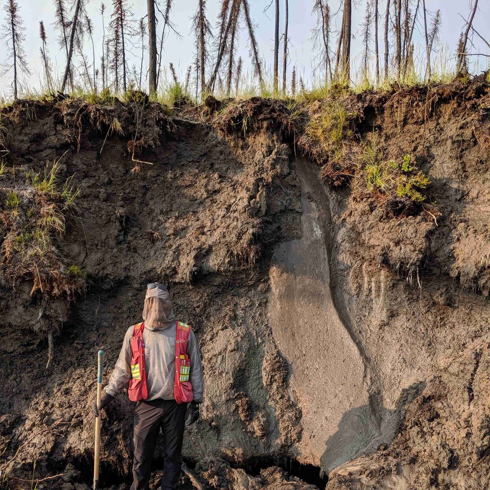
@theronfinley.bsky.social, Panya, Jan, and I were very fortunate to be able to get to the site to survey the impacts of the earthquake. I'm very grateful for how many "once in a lifetime" opportunities we get up here!
@theronfinley.bsky.social, Panya, Jan, and I were very fortunate to be able to get to the site to survey the impacts of the earthquake. I'm very grateful for how many "once in a lifetime" opportunities we get up here!
A sensational guest post by Derek Cronmiller, Theron Finley Panya Lipovsky and Jan Dettmer of the Yukon Geological Survey: Photos and Preliminary Observations from an Overview Flight of the 6 December 2025 Hubbard Glacier Earthquake, Yukon Territory, Canada.
eos.org/thelandslide...
eos.org/thelandslide...

January 5, 2026 at 4:55 PM
Thanks for sharing @davepetley.bsky.social!
@theronfinley.bsky.social, Panya, Jan, and I were very fortunate to be able to get to the site to survey the impacts of the earthquake. I'm very grateful for how many "once in a lifetime" opportunities we get up here!
@theronfinley.bsky.social, Panya, Jan, and I were very fortunate to be able to get to the site to survey the impacts of the earthquake. I'm very grateful for how many "once in a lifetime" opportunities we get up here!
Reposted by GeoCron
I don't usually do this but if you love nature & quality journalism please donate to The Narwhal. Their work is more important than ever, and are currently trying to raise $200,000 to keep the lights on. You get a charitable receipt, and a donor is matching funds. Please share 🧪⚒️
@thenarwhal.ca
@thenarwhal.ca

Alberta officials stalled coal mine pollution study | The Narwhal
An Alberta government scientist was prevented from speaking publicly about his coal mine pollution research, emails show
thenarwhal.ca
December 19, 2025 at 6:04 PM
I don't usually do this but if you love nature & quality journalism please donate to The Narwhal. Their work is more important than ever, and are currently trying to raise $200,000 to keep the lights on. You get a charitable receipt, and a donor is matching funds. Please share 🧪⚒️
@thenarwhal.ca
@thenarwhal.ca
Reposted by GeoCron
Natural Resources Canada has released a national scale maps of active deformation processes based on 2017-2024 Sentinel-1 InSAR data. For best results download the images, load them up in your fav GIS software, and watch out many hours will be spent checking out features you always wondered about.

October 23, 2025 at 1:36 PM
Natural Resources Canada has released a national scale maps of active deformation processes based on 2017-2024 Sentinel-1 InSAR data. For best results download the images, load them up in your fav GIS software, and watch out many hours will be spent checking out features you always wondered about.
Very happy to share another new paper. This one on an entirely different topic; the timing and interaction of alpine glaciers with at the northern margin of the Cordilleran Ice Sheet. www.sciencedirect.com/science/arti...

Timing and interaction of Pleistocene alpine glaciers at the northern margin of the Cordilleran Ice Sheet, southwest Yukon
Stratigraphic and geomorphic analysis paired with 10Be surface exposure dating provides evidence of extensive local ice growth in the Ruby Range, sout…
www.sciencedirect.com
October 21, 2025 at 3:34 PM
Very happy to share another new paper. This one on an entirely different topic; the timing and interaction of alpine glaciers with at the northern margin of the Cordilleran Ice Sheet. www.sciencedirect.com/science/arti...
Reposted by GeoCron

The 17 December 2024 Takhini River landslide and river-ice tsunami in Whitehorse, Yukon, Canada highlights the role of progressive failure in frozen materials.
eos.org/thelandslide...
eos.org/thelandslide...

October 8, 2025 at 7:24 AM
The 17 December 2024 Takhini River landslide and river-ice tsunami in Whitehorse, Yukon, Canada highlights the role of progressive failure in frozen materials.
eos.org/thelandslide...
eos.org/thelandslide...
Here's an article I wrote on a novel landslide that generated a destructive river-ice tsunami on the Takhini River last winter. Definitely a hazard to consider in cold regions. Thanks to the folks who gave me their thoughts and comments on the paper: Panya, Marten, Hig, and anonymous!
rdcu.be/eIe5g
rdcu.be/eIe5g
The 17 december 2024 Takhini River landslide and river-ice tsunami, Whitehorse, Yukon, Canada
rdcu.be
September 30, 2025 at 4:42 AM
Here's an article I wrote on a novel landslide that generated a destructive river-ice tsunami on the Takhini River last winter. Definitely a hazard to consider in cold regions. Thanks to the folks who gave me their thoughts and comments on the paper: Panya, Marten, Hig, and anonymous!
rdcu.be/eIe5g
rdcu.be/eIe5g
Reposted by GeoCron
Over the last three years, @drewbrayshaw.bsky.social, @geocron.bsky.social, me, and twelve colleagues have been compiling a Preliminary Canadian Landslide Database. Version 12 is now available and contains 25,500 entries.
zenodo.org/records/1721...
zenodo.org/records/1721...


September 29, 2025 at 1:16 PM
Over the last three years, @drewbrayshaw.bsky.social, @geocron.bsky.social, me, and twelve colleagues have been compiling a Preliminary Canadian Landslide Database. Version 12 is now available and contains 25,500 entries.
zenodo.org/records/1721...
zenodo.org/records/1721...