


CoCoRaHS Station KY-JC-6
@cocorahskyjc6.bsky.social
Community Collaborative Rain, Hail, & Snow volunteer (https://dex.cocorahs.org/stations/KY-JC-6), #CWOP volunteer & storm spotter in the Daniel Boone N.F. for NWS JKL/LMK plus operate WU PWS KKYMCKEE41 https://wunderground.com/dashboard/pws/KKYMCKEE41.
14 Nov 2025 Climate Summary for #nwsjacksonky, #kymesonet, #DanielBooneNF, & other interests.
High: 69.4°F
Low: 28.0°F
Pcpn.: 0.00"
Snow: 0.0"
Snow Depth: 0.0"
More #wxdata may be found 24/7/365 at wunderground.com/dashboard/pw... #ekywx #kywx #CWOP #ShareYourWeather
High: 69.4°F
Low: 28.0°F
Pcpn.: 0.00"
Snow: 0.0"
Snow Depth: 0.0"
More #wxdata may be found 24/7/365 at wunderground.com/dashboard/pw... #ekywx #kywx #CWOP #ShareYourWeather
Personal Weather Station Dashboard | Weather Underground
Weather Underground provides local & long-range weather forecasts, weather reports, maps & tropical weather conditions for locations worldwide.
wunderground.com
November 14, 2025 at 9:31 PM
14 Nov 2025 Climate Summary for #nwsjacksonky, #kymesonet, #DanielBooneNF, & other interests.
High: 69.4°F
Low: 28.0°F
Pcpn.: 0.00"
Snow: 0.0"
Snow Depth: 0.0"
More #wxdata may be found 24/7/365 at wunderground.com/dashboard/pw... #ekywx #kywx #CWOP #ShareYourWeather
High: 69.4°F
Low: 28.0°F
Pcpn.: 0.00"
Snow: 0.0"
Snow Depth: 0.0"
More #wxdata may be found 24/7/365 at wunderground.com/dashboard/pw... #ekywx #kywx #CWOP #ShareYourWeather
Here is the hyperlocal forecast for the next 3 days from the NWS Office in Jackson KY for @cocorahskyjc6.bsky.social. Get the hyperlocal forecast for your specific location on the NOAA Weather app at the #GooglePlay store. So, what's the weather going to be like in your neighborhood? #ekywx #kywx

November 14, 2025 at 1:19 PM
Here is the hyperlocal forecast for the next 3 days from the NWS Office in Jackson KY for @cocorahskyjc6.bsky.social. Get the hyperlocal forecast for your specific location on the NOAA Weather app at the #GooglePlay store. So, what's the weather going to be like in your neighborhood? #ekywx #kywx
14 Nov 2025 daily observation report using a #CoCoRaHS-approved #CLIMALYTIC Tropo Rain/Snow Gauge along with a #Logia 7-in-1 #WiFi #PWS (Model LOWSC710SWB).
This location reports #wxdata 24/7/365 to #weathercloud & at wunderground.com/dashboard/pws/KKYMCKEE41 #CWOP #ShareYourWeather #ekywx #kywx
This location reports #wxdata 24/7/365 to #weathercloud & at wunderground.com/dashboard/pws/KKYMCKEE41 #CWOP #ShareYourWeather #ekywx #kywx

November 14, 2025 at 1:10 PM
14 Nov 2025 daily observation report using a #CoCoRaHS-approved #CLIMALYTIC Tropo Rain/Snow Gauge along with a #Logia 7-in-1 #WiFi #PWS (Model LOWSC710SWB).
This location reports #wxdata 24/7/365 to #weathercloud & at wunderground.com/dashboard/pws/KKYMCKEE41 #CWOP #ShareYourWeather #ekywx #kywx
This location reports #wxdata 24/7/365 to #weathercloud & at wunderground.com/dashboard/pws/KKYMCKEE41 #CWOP #ShareYourWeather #ekywx #kywx
It's chilly across Central Kentucky and Southern Indiana with temperatures in the 30s and 40s early this morning. Otherwise, today is pleasant with highs in the mid 60s to near 70. 1/2

November 14, 2025 at 1:10 PM
It's chilly across Central Kentucky and Southern Indiana with temperatures in the 30s and 40s early this morning. Otherwise, today is pleasant with highs in the mid 60s to near 70. 1/2
Here is the hyperlocal forecast for the next 36 hours from the NWS Office in Jackson KY for @cocorahskyjc6.bsky.social. Get the hyperlocal forecast for your specific location on the NOAA Weather app at the #GooglePlay store. So, what's the weather going to be like in your neighborhood? #ekywx #kywx

November 13, 2025 at 10:18 PM
Here is the hyperlocal forecast for the next 36 hours from the NWS Office in Jackson KY for @cocorahskyjc6.bsky.social. Get the hyperlocal forecast for your specific location on the NOAA Weather app at the #GooglePlay store. So, what's the weather going to be like in your neighborhood? #ekywx #kywx

13 Nov 2025 Climate Summary near the #HorseLickCreekBioreserveArea, #JacksonCountyKy in the #DanielBooneNF
High: 60.8°F
Low: 28.5°F
Precip: 0.00"
Snow: 0.0"
Snow Depth: 0.0"
More #wxdata may be found 24/7/365 at wunderground.com/dashboard/pws/KKYMCKEE41 #ekywx #kywx #CWOP #ShareYourWeather
High: 60.8°F
Low: 28.5°F
Precip: 0.00"
Snow: 0.0"
Snow Depth: 0.0"
More #wxdata may be found 24/7/365 at wunderground.com/dashboard/pws/KKYMCKEE41 #ekywx #kywx #CWOP #ShareYourWeather
Personal Weather Station Dashboard | Weather Underground
Weather Underground provides local & long-range weather forecasts, weather reports, maps & tropical weather conditions for locations worldwide.
wunderground.com
November 13, 2025 at 10:02 PM
13 Nov 2025 Climate Summary near the #HorseLickCreekBioreserveArea, #JacksonCountyKy in the #DanielBooneNF
High: 60.8°F
Low: 28.5°F
Precip: 0.00"
Snow: 0.0"
Snow Depth: 0.0"
More #wxdata may be found 24/7/365 at wunderground.com/dashboard/pws/KKYMCKEE41 #ekywx #kywx #CWOP #ShareYourWeather
High: 60.8°F
Low: 28.5°F
Precip: 0.00"
Snow: 0.0"
Snow Depth: 0.0"
More #wxdata may be found 24/7/365 at wunderground.com/dashboard/pws/KKYMCKEE41 #ekywx #kywx #CWOP #ShareYourWeather
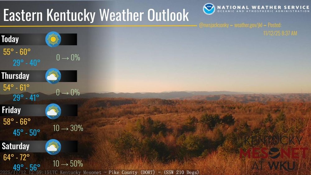
Here is the hyperlocal forecast for the next 7 days from the NWS Office in Jackson KY for @cocorahskyjc6.bsky.social. Get the hyperlocal forecast for your specific location on the NOAA Weather app at the #GooglePlay store. So, what's the weather going to be like in your neighborhood? #ekywx #kywx

November 13, 2025 at 1:21 PM
Here is the hyperlocal forecast for the next 7 days from the NWS Office in Jackson KY for @cocorahskyjc6.bsky.social. Get the hyperlocal forecast for your specific location on the NOAA Weather app at the #GooglePlay store. So, what's the weather going to be like in your neighborhood? #ekywx #kywx
Here is the hyperlocal forecast for the next 3 days from the NWS Office in Jackson KY for @cocorahskyjc6.bsky.social. Get the hyperlocal forecast for your specific location on the NOAA Weather app at the #GooglePlay store. So, what's the weather going to be like in your neighborhood? #ekywx #kywx

November 13, 2025 at 1:20 PM
Here is the hyperlocal forecast for the next 3 days from the NWS Office in Jackson KY for @cocorahskyjc6.bsky.social. Get the hyperlocal forecast for your specific location on the NOAA Weather app at the #GooglePlay store. So, what's the weather going to be like in your neighborhood? #ekywx #kywx
High pressure will bring slightly cooler temperatures to East Kentucky today. Temperatures will moderate from Friday into Saturday as a warm front lifts across the region followed by a cold front on Saturday night. Shower chances return as these fronts & upper disturbances pass through. #ekywx #kywx

November 13, 2025 at 1:18 PM
High pressure will bring slightly cooler temperatures to East Kentucky today. Temperatures will moderate from Friday into Saturday as a warm front lifts across the region followed by a cold front on Saturday night. Shower chances return as these fronts & upper disturbances pass through. #ekywx #kywx
13 Nov 2025 daily observation report using a #CoCoRaHS-approved #CLIMALYTIC Tropo Rain/Snow Gauge along with a #Logia 7-in-1 #WiFi #PWS (Model LOWSC710SWB).
This location reports #wxdata 24/7/365 to #weathercloud & at wunderground.com/dashboard/pws/KKYMCKEE41 #CWOP #ShareYourWeather #ekywx #kywx
This location reports #wxdata 24/7/365 to #weathercloud & at wunderground.com/dashboard/pws/KKYMCKEE41 #CWOP #ShareYourWeather #ekywx #kywx

November 13, 2025 at 1:16 PM
13 Nov 2025 daily observation report using a #CoCoRaHS-approved #CLIMALYTIC Tropo Rain/Snow Gauge along with a #Logia 7-in-1 #WiFi #PWS (Model LOWSC710SWB).
This location reports #wxdata 24/7/365 to #weathercloud & at wunderground.com/dashboard/pws/KKYMCKEE41 #CWOP #ShareYourWeather #ekywx #kywx
This location reports #wxdata 24/7/365 to #weathercloud & at wunderground.com/dashboard/pws/KKYMCKEE41 #CWOP #ShareYourWeather #ekywx #kywx

12 Nov 2025 Climate Summary for #nwsjacksonky, #kymesonet, #DanielBooneNF, & other interests.
High: 62.2°F
Low: 30.2°F
Pcpn.: 0.00"
Snow: 0.0"
Snow Depth: 0.0"
More #wxdata may be found 24/7/365 at wunderground.com/dashboard/pw... #ekywx #kywx #CWOP #ShareYourWeather
High: 62.2°F
Low: 30.2°F
Pcpn.: 0.00"
Snow: 0.0"
Snow Depth: 0.0"
More #wxdata may be found 24/7/365 at wunderground.com/dashboard/pw... #ekywx #kywx #CWOP #ShareYourWeather
Personal Weather Station Dashboard | Weather Underground
Weather Underground provides local & long-range weather forecasts, weather reports, maps & tropical weather conditions for locations worldwide.
wunderground.com
November 13, 2025 at 5:03 AM
12 Nov 2025 Climate Summary for #nwsjacksonky, #kymesonet, #DanielBooneNF, & other interests.
High: 62.2°F
Low: 30.2°F
Pcpn.: 0.00"
Snow: 0.0"
Snow Depth: 0.0"
More #wxdata may be found 24/7/365 at wunderground.com/dashboard/pw... #ekywx #kywx #CWOP #ShareYourWeather
High: 62.2°F
Low: 30.2°F
Pcpn.: 0.00"
Snow: 0.0"
Snow Depth: 0.0"
More #wxdata may be found 24/7/365 at wunderground.com/dashboard/pw... #ekywx #kywx #CWOP #ShareYourWeather
Here is the hyperlocal forecast for the next 36 hours from the NWS Office in Jackson KY for @cocorahskyjc6.bsky.social. Get the hyperlocal forecast for your specific location on the NOAA Weather app at the #GooglePlay store. So, what's the weather going to be like in your neighborhood? #ekywx #kywx

November 12, 2025 at 10:33 PM
Here is the hyperlocal forecast for the next 36 hours from the NWS Office in Jackson KY for @cocorahskyjc6.bsky.social. Get the hyperlocal forecast for your specific location on the NOAA Weather app at the #GooglePlay store. So, what's the weather going to be like in your neighborhood? #ekywx #kywx
12 Nov 2025 daily observation report using a #CoCoRaHS-approved #CLIMALYTIC Tropo Rain/Snow Gauge along with a #Logia 7-in-1 #WiFi #PWS (Model LOWSC710SWB).
This location reports #wxdata 24/7/365 to #weathercloud & at wunderground.com/dashboard/pws/KKYMCKEE41 #CWOP #ShareYourWeather #ekywx #kywx
This location reports #wxdata 24/7/365 to #weathercloud & at wunderground.com/dashboard/pws/KKYMCKEE41 #CWOP #ShareYourWeather #ekywx #kywx

November 12, 2025 at 2:06 PM
12 Nov 2025 daily observation report using a #CoCoRaHS-approved #CLIMALYTIC Tropo Rain/Snow Gauge along with a #Logia 7-in-1 #WiFi #PWS (Model LOWSC710SWB).
This location reports #wxdata 24/7/365 to #weathercloud & at wunderground.com/dashboard/pws/KKYMCKEE41 #CWOP #ShareYourWeather #ekywx #kywx
This location reports #wxdata 24/7/365 to #weathercloud & at wunderground.com/dashboard/pws/KKYMCKEE41 #CWOP #ShareYourWeather #ekywx #kywx


11 Nov 2025 Climate Summary near the #HorseLickCreekBioreserveArea, #JacksonCountyKy in the #DanielBooneNF
High: 41.9°F
Low: 17.4°F
Precip: 0.00"
Snow: 0.0"
Snow Depth: 0.0"
More #wxdata may be found 24/7/365 at wunderground.com/dashboard/pws/KKYMCKEE41 #ekywx #kywx #CWOP #ShareYourWeather
High: 41.9°F
Low: 17.4°F
Precip: 0.00"
Snow: 0.0"
Snow Depth: 0.0"
More #wxdata may be found 24/7/365 at wunderground.com/dashboard/pws/KKYMCKEE41 #ekywx #kywx #CWOP #ShareYourWeather
Personal Weather Station Dashboard | Weather Underground
Weather Underground provides local & long-range weather forecasts, weather reports, maps & tropical weather conditions for locations worldwide.
wunderground.com
November 12, 2025 at 2:59 AM
11 Nov 2025 Climate Summary near the #HorseLickCreekBioreserveArea, #JacksonCountyKy in the #DanielBooneNF
High: 41.9°F
Low: 17.4°F
Precip: 0.00"
Snow: 0.0"
Snow Depth: 0.0"
More #wxdata may be found 24/7/365 at wunderground.com/dashboard/pws/KKYMCKEE41 #ekywx #kywx #CWOP #ShareYourWeather
High: 41.9°F
Low: 17.4°F
Precip: 0.00"
Snow: 0.0"
Snow Depth: 0.0"
More #wxdata may be found 24/7/365 at wunderground.com/dashboard/pws/KKYMCKEE41 #ekywx #kywx #CWOP #ShareYourWeather
Reposted by CoCoRaHS Station KY-JC-6

University of Nebraska announced yesterday a final budget plan which if approved by regents would result in elimination of its earth and atmospheric sciences program. I worry that this is a sign of a trend that could damage the academic meteorology sector of the US. More: tinyurl.com/53b5f5j7

University of Nebraska pushes forward with plan to eliminate atmospheric sciences program
Record cold gives way to warmth and signs of an increasingly stormy pattern for western and central US
tinyurl.com
November 11, 2025 at 6:18 PM
University of Nebraska announced yesterday a final budget plan which if approved by regents would result in elimination of its earth and atmospheric sciences program. I worry that this is a sign of a trend that could damage the academic meteorology sector of the US. More: tinyurl.com/53b5f5j7
@jkl.nws-bot.us #JKL at 349 PM EDT on 11 Nov issued a Hazardous Weather Outlook (HWO) for Eastern Kentucky. See mesonet.agron.iastate.edu/wx/afos/p.ph... #ekywx #kywx

November 11, 2025 at 9:11 PM
@jkl.nws-bot.us #JKL at 349 PM EDT on 11 Nov issued a Hazardous Weather Outlook (HWO) for Eastern Kentucky. See mesonet.agron.iastate.edu/wx/afos/p.ph... #ekywx #kywx
@sdf.nws-bot.us #LMK issued a Hazardous Weather Outlook (HWO) at 2:42 PM EST on 11 Nov for Central Kentucky and Southern Indiana. Details at 👉 mesonet.agron.iastate.edu/wx/afos/p.ph... #kywx #inwx

November 11, 2025 at 9:02 PM
@sdf.nws-bot.us #LMK issued a Hazardous Weather Outlook (HWO) at 2:42 PM EST on 11 Nov for Central Kentucky and Southern Indiana. Details at 👉 mesonet.agron.iastate.edu/wx/afos/p.ph... #kywx #inwx
A Geomagnetic Storm Watch G4 (Severe) is now posted for 12 Nov. The recent, fast CME is anticipated to arrive about midday on 12 Nov and G4 potential exists. Please see our latest model run at www.swpc.noaa.gov/products/wsa... and stay aware at spaceweather.gov

November 11, 2025 at 8:51 PM
A Geomagnetic Storm Watch G4 (Severe) is now posted for 12 Nov. The recent, fast CME is anticipated to arrive about midday on 12 Nov and G4 potential exists. Please see our latest model run at www.swpc.noaa.gov/products/wsa... and stay aware at spaceweather.gov
❄️Saw a widespread Trace to just over an inch of snowfall on Monday. This is possibly an underestimation, given how quickly the snow melted on the ground.
📏Send in your snow reports and/or join the #CoCoRaHS program and #ShareYourWeather #ekywx #kywx
📏Send in your snow reports and/or join the #CoCoRaHS program and #ShareYourWeather #ekywx #kywx

November 11, 2025 at 3:29 PM
❄️Saw a widespread Trace to just over an inch of snowfall on Monday. This is possibly an underestimation, given how quickly the snow melted on the ground.
📏Send in your snow reports and/or join the #CoCoRaHS program and #ShareYourWeather #ekywx #kywx
📏Send in your snow reports and/or join the #CoCoRaHS program and #ShareYourWeather #ekywx #kywx
Temperatures will moderate today across East KY, but still remain 15 to 20 degrees below normal. Temps will gradually moderate thru the week and into the upcoming weekend. The next chances for rain showers arrive to end the week as a series of systems are forecast to cross the OH Valley. #ekywx

November 11, 2025 at 3:28 PM
Temperatures will moderate today across East KY, but still remain 15 to 20 degrees below normal. Temps will gradually moderate thru the week and into the upcoming weekend. The next chances for rain showers arrive to end the week as a series of systems are forecast to cross the OH Valley. #ekywx