


CoCoRaHS Station KY-JC-6
@cocorahskyjc6.bsky.social
Community Collaborative Rain, Hail, & Snow volunteer (https://dex.cocorahs.org/stations/KY-JC-6), #CWOP volunteer & storm spotter in the Daniel Boone N.F. for NWS JKL/LMK plus operate WU PWS KKYMCKEE41 https://wunderground.com/dashboard/pws/KKYMCKEE41.
22 Nov 2025 daily observation report using a #CoCoRaHS-approved #CLIMALYTIC Tropo Rain/Snow Gauge along with a #Logia 7-in-1 #WiFi #PWS (Model LOWSC710SWB).
This location reports #wxdata 24/7/365 to #weathercloud & at wunderground.com/dashboard/pws/KKYMCKEE41 #CWOP #ShareYourWeather #ekywx #kywx
This location reports #wxdata 24/7/365 to #weathercloud & at wunderground.com/dashboard/pws/KKYMCKEE41 #CWOP #ShareYourWeather #ekywx #kywx


November 22, 2025 at 12:29 PM
22 Nov 2025 daily observation report using a #CoCoRaHS-approved #CLIMALYTIC Tropo Rain/Snow Gauge along with a #Logia 7-in-1 #WiFi #PWS (Model LOWSC710SWB).
This location reports #wxdata 24/7/365 to #weathercloud & at wunderground.com/dashboard/pws/KKYMCKEE41 #CWOP #ShareYourWeather #ekywx #kywx
This location reports #wxdata 24/7/365 to #weathercloud & at wunderground.com/dashboard/pws/KKYMCKEE41 #CWOP #ShareYourWeather #ekywx #kywx
@sdf.nws-bot.us #LMK at 3:04 AM EST on 22 Nov issued a Hazardous Weather Outlook (HWO) for Central Kentucky and Southern Indiana. Details 👉 at mesonet.agron.iastate.edu/wx/afos/p.ph... #kywx #inwx

November 22, 2025 at 12:28 PM
@sdf.nws-bot.us #LMK at 3:04 AM EST on 22 Nov issued a Hazardous Weather Outlook (HWO) for Central Kentucky and Southern Indiana. Details 👉 at mesonet.agron.iastate.edu/wx/afos/p.ph... #kywx #inwx
@jkl.nws-bot.us #JKL issued a Hazardous Weather Outlook (HWO) at 2:04 AM EST on 22 Nov for Eastern Kentucky. Details 👉 at mesonet.agron.iastate.edu/wx/afos/p.ph... #ekywx #kywx

November 22, 2025 at 12:25 PM
@jkl.nws-bot.us #JKL issued a Hazardous Weather Outlook (HWO) at 2:04 AM EST on 22 Nov for Eastern Kentucky. Details 👉 at mesonet.agron.iastate.edu/wx/afos/p.ph... #ekywx #kywx
@jkl.nws-bot.us #JKL issued a Hazardous Weather Outlook (HWO) at 10:43 PM EST on 21 Nov for Eastern Kentucky. Details 👉 at mesonet.agron.iastate.edu/wx/afos/p.ph... #ekywx #kywx

November 22, 2025 at 5:27 AM
@jkl.nws-bot.us #JKL issued a Hazardous Weather Outlook (HWO) at 10:43 PM EST on 21 Nov for Eastern Kentucky. Details 👉 at mesonet.agron.iastate.edu/wx/afos/p.ph... #ekywx #kywx
21 Nov 2025 daily observation report using a #CoCoRaHS-approved #CLIMALYTIC Tropo Rain/Snow Gauge along with a #Logia 7-in-1 #WiFi #PWS (Model LOWSC710SWB).
This location reports #wxdata 24/7/365 to #weathercloud & at wunderground.com/dashboard/pws/KKYMCKEE41 #CWOP #ShareYourWeather #ekywx #kywx
This location reports #wxdata 24/7/365 to #weathercloud & at wunderground.com/dashboard/pws/KKYMCKEE41 #CWOP #ShareYourWeather #ekywx #kywx


November 21, 2025 at 8:22 PM
21 Nov 2025 daily observation report using a #CoCoRaHS-approved #CLIMALYTIC Tropo Rain/Snow Gauge along with a #Logia 7-in-1 #WiFi #PWS (Model LOWSC710SWB).
This location reports #wxdata 24/7/365 to #weathercloud & at wunderground.com/dashboard/pws/KKYMCKEE41 #CWOP #ShareYourWeather #ekywx #kywx
This location reports #wxdata 24/7/365 to #weathercloud & at wunderground.com/dashboard/pws/KKYMCKEE41 #CWOP #ShareYourWeather #ekywx #kywx
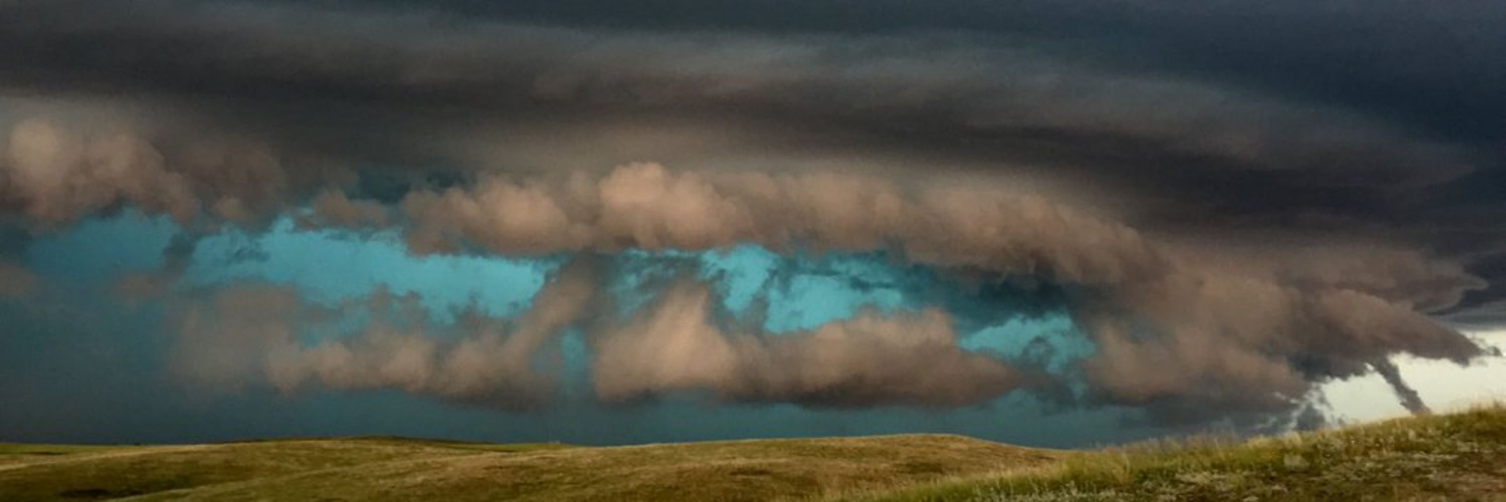
Clouds will linger for much of the daytime hours on Thursday across East Kentucky with rain chances spreading from SW->NE overnight. Heavier rain, and perhaps a few thunderstorms, will dominate Friday's forecast before a cold front sweeps through on Saturday. Sunday looks drier though! #ekywx #kywx

November 20, 2025 at 8:44 PM
Here is the extended forecast for the next 7 days from the NWS Office in Jackson KY for @cocorahskyjc6.bsky.social. Get the hyperlocal forecast for your specific location on the NOAA Weather app at the #GooglePlay store. So, what's the weather going to be like in your neighborhood? #ekywx #kywx

November 20, 2025 at 12:54 PM
Here is the extended forecast for the next 7 days from the NWS Office in Jackson KY for @cocorahskyjc6.bsky.social. Get the hyperlocal forecast for your specific location on the NOAA Weather app at the #GooglePlay store. So, what's the weather going to be like in your neighborhood? #ekywx #kywx
Here is the hyperlocal forecast for the next 2 days from the NWS Office in Jackson KY for @cocorahskyjc6.bsky.social. Get the hyperlocal forecast for your specific location on the NOAA Weather app at the #GooglePlay store. So, what's the weather going to be like in your neighborhood? #ekywx #kywx

November 20, 2025 at 12:54 PM
Here is the hyperlocal forecast for the next 2 days from the NWS Office in Jackson KY for @cocorahskyjc6.bsky.social. Get the hyperlocal forecast for your specific location on the NOAA Weather app at the #GooglePlay store. So, what's the weather going to be like in your neighborhood? #ekywx #kywx
Here is a map of daily observation reports from #CoCoRaHS volunteers across portions of Central and Eastern Kentucky which can be found at maps.cocorahs.org?maptype=prec.... So why not join the thousands of weather enthusiasts today across the US, Canada, and the Bahamas and let us #ShareOurWeather!

November 20, 2025 at 12:51 PM
Here is a map of daily observation reports from #CoCoRaHS volunteers across portions of Central and Eastern Kentucky which can be found at maps.cocorahs.org?maptype=prec.... So why not join the thousands of weather enthusiasts today across the US, Canada, and the Bahamas and let us #ShareOurWeather!
20 Nov 2025 daily observation report using a #CoCoRaHS-approved #CLIMALYTIC Tropo Rain/Snow Gauge along with a #Logia 7-in-1 #WiFi #PWS (Model LOWSC710SWB).
This location reports #wxdata 24/7/365 to #weathercloud & at wunderground.com/dashboard/pws/KKYMCKEE41 #CWOP #ShareYourWeather #ekywx #kywx
This location reports #wxdata 24/7/365 to #weathercloud & at wunderground.com/dashboard/pws/KKYMCKEE41 #CWOP #ShareYourWeather #ekywx #kywx


November 20, 2025 at 12:35 PM
20 Nov 2025 daily observation report using a #CoCoRaHS-approved #CLIMALYTIC Tropo Rain/Snow Gauge along with a #Logia 7-in-1 #WiFi #PWS (Model LOWSC710SWB).
This location reports #wxdata 24/7/365 to #weathercloud & at wunderground.com/dashboard/pws/KKYMCKEE41 #CWOP #ShareYourWeather #ekywx #kywx
This location reports #wxdata 24/7/365 to #weathercloud & at wunderground.com/dashboard/pws/KKYMCKEE41 #CWOP #ShareYourWeather #ekywx #kywx
@sdf.nws-bot.us #LMK at 3:54 AM EST on 20 Nov issued a Hazardous Weather Outlook (HWO) for Central Kentucky and Southern Indiana. Details 👉 at mesonet.agron.iastate.edu/wx/afos/p.ph... #kywx #inwx

November 20, 2025 at 12:34 PM
@sdf.nws-bot.us #LMK at 3:54 AM EST on 20 Nov issued a Hazardous Weather Outlook (HWO) for Central Kentucky and Southern Indiana. Details 👉 at mesonet.agron.iastate.edu/wx/afos/p.ph... #kywx #inwx
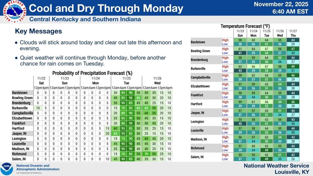
More cloudy skies and cool weather is expected today across Central Kentucky and Southern Indiana, with rain chances increasing from west to east. Waves of rain showers and a few storms will continue off and on between today and Saturday morning. Drier weather returns this weekend. #kywx #inwx

November 20, 2025 at 12:25 PM
Here is the extended forecast for the next 7 days from the NWS Office in Jackson KY for @cocorahskyjc6.bsky.social. Get the hyperlocal forecast for your specific location on the NOAA Weather app at the #GooglePlay store. So, what's the weather going to be like in your neighborhood? #ekywx #kywx

November 19, 2025 at 12:51 PM
Here is the extended forecast for the next 7 days from the NWS Office in Jackson KY for @cocorahskyjc6.bsky.social. Get the hyperlocal forecast for your specific location on the NOAA Weather app at the #GooglePlay store. So, what's the weather going to be like in your neighborhood? #ekywx #kywx
Here is the hyperlocal forecast for the next 2 days from the NWS Office in Jackson KY for @cocorahskyjc6.bsky.social. Get the hyperlocal forecast for your specific location on the NOAA Weather app at the #GooglePlay store. So, what's the weather going to be like in your neighborhood? #ekywx #kywx

November 19, 2025 at 12:50 PM
Here is the hyperlocal forecast for the next 2 days from the NWS Office in Jackson KY for @cocorahskyjc6.bsky.social. Get the hyperlocal forecast for your specific location on the NOAA Weather app at the #GooglePlay store. So, what's the weather going to be like in your neighborhood? #ekywx #kywx
19 Nov 2025 daily observation report using a #CoCoRaHS-approved #CLIMALYTIC Tropo Rain/Snow Gauge along with a #Logia 7-in-1 #WiFi #PWS (Model LOWSC710SWB).
This location reports #wxdata 24/7/365 to #weathercloud & at wunderground.com/dashboard/pws/KKYMCKEE41 #CWOP #ShareYourWeather #ekywx #kywx
This location reports #wxdata 24/7/365 to #weathercloud & at wunderground.com/dashboard/pws/KKYMCKEE41 #CWOP #ShareYourWeather #ekywx #kywx


November 19, 2025 at 12:42 PM
19 Nov 2025 daily observation report using a #CoCoRaHS-approved #CLIMALYTIC Tropo Rain/Snow Gauge along with a #Logia 7-in-1 #WiFi #PWS (Model LOWSC710SWB).
This location reports #wxdata 24/7/365 to #weathercloud & at wunderground.com/dashboard/pws/KKYMCKEE41 #CWOP #ShareYourWeather #ekywx #kywx
This location reports #wxdata 24/7/365 to #weathercloud & at wunderground.com/dashboard/pws/KKYMCKEE41 #CWOP #ShareYourWeather #ekywx #kywx
@sdf.nws-bot.us #LMK issued at 400 AM EST on 19 Nov a Hazardous Weather Outlook (HWO) for Central Kentucky and Southern Indiana. Details 👉 at mesonet.agron.iastate.edu/wx/afos/p.ph... #kywx #inwx

November 19, 2025 at 12:24 PM
@sdf.nws-bot.us #LMK issued at 400 AM EST on 19 Nov a Hazardous Weather Outlook (HWO) for Central Kentucky and Southern Indiana. Details 👉 at mesonet.agron.iastate.edu/wx/afos/p.ph... #kywx #inwx
@sdf.nws-bot.us #LMK at 431 AM EST on 18 Nov issued a Special Weather Statement (SPS) until 915 AM EST concerning areas of patchy drizzle and reduced visibility caused by fog for Central Kentucky and Southern Indiana. Details 👉 at mesonet.agron.iastate.edu/wx/afos/p.ph... #kywx #inwx


November 19, 2025 at 12:22 PM
@sdf.nws-bot.us #LMK at 431 AM EST on 18 Nov issued a Special Weather Statement (SPS) until 915 AM EST concerning areas of patchy drizzle and reduced visibility caused by fog for Central Kentucky and Southern Indiana. Details 👉 at mesonet.agron.iastate.edu/wx/afos/p.ph... #kywx #inwx
@jkl.nws-bot.us #JKL issued a Hazardous Weather Outlook (HWO) at 5:31 AM EST on 19 Nov for Eastern Kentucky. Details 👉 at mesonet.agron.iastate.edu/wx/afos/p.ph... A Special Weather Statement (SPS) for areas of widespread, locally dense fog remains in effect until 930 AM EST. #ekywx #kywx


November 19, 2025 at 12:16 PM
@jkl.nws-bot.us #JKL issued a Hazardous Weather Outlook (HWO) at 5:31 AM EST on 19 Nov for Eastern Kentucky. Details 👉 at mesonet.agron.iastate.edu/wx/afos/p.ph... A Special Weather Statement (SPS) for areas of widespread, locally dense fog remains in effect until 930 AM EST. #ekywx #kywx
@jkl.nws-bot.us #JKL issued a Special Weather Statement (SPS) at 528 AM EST in 19 Nov concerning areas of widespread, locally dense fog until 930 AM EST for Eastern Kentucky. Details 👉 at mesonet.agron.iastate.edu/wx/afos/p.ph... #ekywx #kywx

November 19, 2025 at 12:12 PM
@jkl.nws-bot.us #JKL issued a Special Weather Statement (SPS) at 528 AM EST in 19 Nov concerning areas of widespread, locally dense fog until 930 AM EST for Eastern Kentucky. Details 👉 at mesonet.agron.iastate.edu/wx/afos/p.ph... #ekywx #kywx
A few strong to severe storms are possible today into tonight across Central Kentucky and Southern Indiana. Today, the main severe potential will be small hail, while a spin-up tornado can't be ruled out in the areas circled in red this evening. 1/2

November 18, 2025 at 2:44 PM
A few strong to severe storms are possible today into tonight across Central Kentucky and Southern Indiana. Today, the main severe potential will be small hail, while a spin-up tornado can't be ruled out in the areas circled in red this evening. 1/2
18 Nov 2025 daily observation report using a #CoCoRaHS-approved #CLIMALYTIC Tropo Rain/Snow Gauge along with a #Logia 7-in-1 #WiFi #PWS (Model LOWSC710SWB).
This location reports #wxdata 24/7/365 to #weathercloud & at wunderground.com/dashboard/pws/KKYMCKEE41 #CWOP #ShareYourWeather #ekywx #kywx
This location reports #wxdata 24/7/365 to #weathercloud & at wunderground.com/dashboard/pws/KKYMCKEE41 #CWOP #ShareYourWeather #ekywx #kywx


November 18, 2025 at 2:39 PM
18 Nov 2025 daily observation report using a #CoCoRaHS-approved #CLIMALYTIC Tropo Rain/Snow Gauge along with a #Logia 7-in-1 #WiFi #PWS (Model LOWSC710SWB).
This location reports #wxdata 24/7/365 to #weathercloud & at wunderground.com/dashboard/pws/KKYMCKEE41 #CWOP #ShareYourWeather #ekywx #kywx
This location reports #wxdata 24/7/365 to #weathercloud & at wunderground.com/dashboard/pws/KKYMCKEE41 #CWOP #ShareYourWeather #ekywx #kywx
As a warm front moves through the area on Tuesday, a steep temperature gradient will emerge across Eastern Kentucky. In areas further to the south/west, warmer afternoon temperatures could support some stronger storms. Please #beweatheraware, especially if you live west of I-75! #ekywx #kywx #inwx


November 17, 2025 at 10:42 PM
As a warm front moves through the area on Tuesday, a steep temperature gradient will emerge across Eastern Kentucky. In areas further to the south/west, warmer afternoon temperatures could support some stronger storms. Please #beweatheraware, especially if you live west of I-75! #ekywx #kywx #inwx
A few strong to severe storms are possible Tuesday afternoon and evening across Central Kentucky and Southern Indiana. #BePrepared #StayWeatherAware #kywx #inwx
November 17, 2025 at 10:39 PM
A few strong to severe storms are possible Tuesday afternoon and evening across Central Kentucky and Southern Indiana. #BePrepared #StayWeatherAware #kywx #inwx
@jkl.nws-bot.us #JKL issued a Hazardous Weather Outlook (HWO) at 249 PM EST on 17 Nov for Eastern Kentucky. Details 👉 at mesonet.agron.iastate.edu/wx/afos/p.ph... #ekywx #kywx

November 17, 2025 at 10:37 PM
@jkl.nws-bot.us #JKL issued a Hazardous Weather Outlook (HWO) at 249 PM EST on 17 Nov for Eastern Kentucky. Details 👉 at mesonet.agron.iastate.edu/wx/afos/p.ph... #ekywx #kywx