


Jenna C. Hill
@chillocean.bsky.social
Marine Geologist w/USGS; likes to nerd out about marine geohazards, paleoclimate and seascape evolution; lover of dogs, soccer et al.
A great partnership leads to great science! 🧪⚒️🌊
Read our new paper here: www.science.org/doi/10.1126/...
Read our new paper here: www.science.org/doi/10.1126/...

New research led by @chillocean.bsky.social and the USGS Pacific Coastal and Marine Science Center used MBARI’s technology to map the distribution of deposits left on the seafloor after an earthquake, revealing the seismic history of the Pacific Northwest.
Learn more: www.mbari.org/news/mbaris-...
Learn more: www.mbari.org/news/mbaris-...

MBARI’s advanced underwater technology reveals history of earthquakes in the Pacific Northwest • MBARI
A new research publication, led by the USGS Pacific Coastal and Marine Science Center, used MBARI’s advanced technology to map the distribution of deposits left on the abyssal seafloor after an earthq...
www.mbari.org
January 20, 2026 at 4:48 PM
A great partnership leads to great science! 🧪⚒️🌊
Read our new paper here: www.science.org/doi/10.1126/...
Read our new paper here: www.science.org/doi/10.1126/...
ICYMI: Our #USGS #scicomm put together a great video about our research into #earthquake records in the Cascadia subduction zone. 🧪⚒️🌊
You can read our new paper in Science Advances here: www.science.org/doi/10.1126/...
You can read our new paper in Science Advances here: www.science.org/doi/10.1126/...
January 16, 2026 at 3:50 PM
ICYMI: Our #USGS #scicomm put together a great video about our research into #earthquake records in the Cascadia subduction zone. 🧪⚒️🌊
You can read our new paper in Science Advances here: www.science.org/doi/10.1126/...
You can read our new paper in Science Advances here: www.science.org/doi/10.1126/...
I’ve enticed our geophysicists into working in the sediment core lab…but they’re still on probation lol. 😉
January 16, 2026 at 3:16 AM
I’ve enticed our geophysicists into working in the sediment core lab…but they’re still on probation lol. 😉
Also, a big shout out to my #USGS and #MBARI colleagues! Collaborating on this project allows us to both work with a great team of scientists and provides access to cutting edge tools like @mbarinews.bsky.social AUVs and ROVs that offer unprecedented views of the deep seafloor. 🧪⚒️🌊

MBARI’s advanced underwater technology reveals history of earthquakes in the Pacific Northwest • MBARI
A new research publication, led by the USGS Pacific Coastal and Marine Science Center, used MBARI’s advanced technology to map the distribution of deposits left on the abyssal seafloor after an earthq...
www.mbari.org
January 14, 2026 at 10:13 PM
Also, a big shout out to my #USGS and #MBARI colleagues! Collaborating on this project allows us to both work with a great team of scientists and provides access to cutting edge tools like @mbarinews.bsky.social AUVs and ROVs that offer unprecedented views of the deep seafloor. 🧪⚒️🌊
This study is part of a much larger USGS effort to characterize geologic records of past earthquakes and reduce uncertainties in earthquake recurrence estimates that are used seismic hazard models. 🧪⚒️🌊
Read more about our project here:
www.usgs.gov/centers/pcms...
Read more about our project here:
www.usgs.gov/centers/pcms...

Cascadia Subduction Zone Marine Geohazards
Societal Issue: Uncertainty related to rupture extent, slip distribution, and recurrence of past subduction megathrust earthquakes in the Pacific Northwest (northern CA, OR, WA, and southern BC) leads...
www.usgs.gov
January 14, 2026 at 9:31 PM
This study is part of a much larger USGS effort to characterize geologic records of past earthquakes and reduce uncertainties in earthquake recurrence estimates that are used seismic hazard models. 🧪⚒️🌊
Read more about our project here:
www.usgs.gov/centers/pcms...
Read more about our project here:
www.usgs.gov/centers/pcms...
Overall, this study changes the focus of how the scientific community studies prehistoric earthquakes in a subduction zone, reduces the uncertainties in the timing and frequency of large subduction zone earthquakes, and offers new opportunities to develop global earthquake records.🧪⚒️🌊
January 14, 2026 at 9:31 PM
Overall, this study changes the focus of how the scientific community studies prehistoric earthquakes in a subduction zone, reduces the uncertainties in the timing and frequency of large subduction zone earthquakes, and offers new opportunities to develop global earthquake records.🧪⚒️🌊
We propose a new geologic model for subduction zone marine paleoseismology that emphasizes uplift & recycling of the abyssal seafloor. Accretion and oversteepening on the lower slope sets the stage for landslides and provides a perpetual source of material to fail during each earthquake cycle.
🧪⚒️🌊
🧪⚒️🌊

January 14, 2026 at 9:31 PM
We propose a new geologic model for subduction zone marine paleoseismology that emphasizes uplift & recycling of the abyssal seafloor. Accretion and oversteepening on the lower slope sets the stage for landslides and provides a perpetual source of material to fail during each earthquake cycle.
🧪⚒️🌊
🧪⚒️🌊
We think these landslides, which happen on the steep base of continental slopes, are happening along subduction zones globally. This means we should be able to find similar landslide deposits and associated marine turbidites in many places around the world.
🧪⚒️🌊
🧪⚒️🌊
January 14, 2026 at 9:31 PM
We think these landslides, which happen on the steep base of continental slopes, are happening along subduction zones globally. This means we should be able to find similar landslide deposits and associated marine turbidites in many places around the world.
🧪⚒️🌊
🧪⚒️🌊
The punctuated timing of these underwater landslides also suggests evidence for seafloor movement during large earthquakes, similar to what was observed during the 2011 Tohoku earthquake and tsunami in Japan. If this were to happen in Cascadia, it could enhance tsunami hazards across the region. 🧪⚒️🌊
January 14, 2026 at 9:31 PM
The punctuated timing of these underwater landslides also suggests evidence for seafloor movement during large earthquakes, similar to what was observed during the 2011 Tohoku earthquake and tsunami in Japan. If this were to happen in Cascadia, it could enhance tsunami hazards across the region. 🧪⚒️🌊
Our results show the links landslide scars on the lower slope, large debris deposits and abyssal turbidites. By clarifying how and where earthquake triggered turbidites are generated, our results improve confidence in using these deposits to reconstruct long-term earthquake histories. 🧪⚒️🌊
January 14, 2026 at 9:31 PM
Our results show the links landslide scars on the lower slope, large debris deposits and abyssal turbidites. By clarifying how and where earthquake triggered turbidites are generated, our results improve confidence in using these deposits to reconstruct long-term earthquake histories. 🧪⚒️🌊
Our study shows that large megathrust earthquakes generate widespread landslides on the seafloor, with characteristic deposits called turbidites that can reliably be used to reconstruct earthquake history. 🧪⚒️🌊
Check out this USGS video describing our new findings:
Check out this USGS video describing our new findings:
January 14, 2026 at 9:31 PM
Our study shows that large megathrust earthquakes generate widespread landslides on the seafloor, with characteristic deposits called turbidites that can reliably be used to reconstruct earthquake history. 🧪⚒️🌊
Check out this USGS video describing our new findings:
Check out this USGS video describing our new findings:
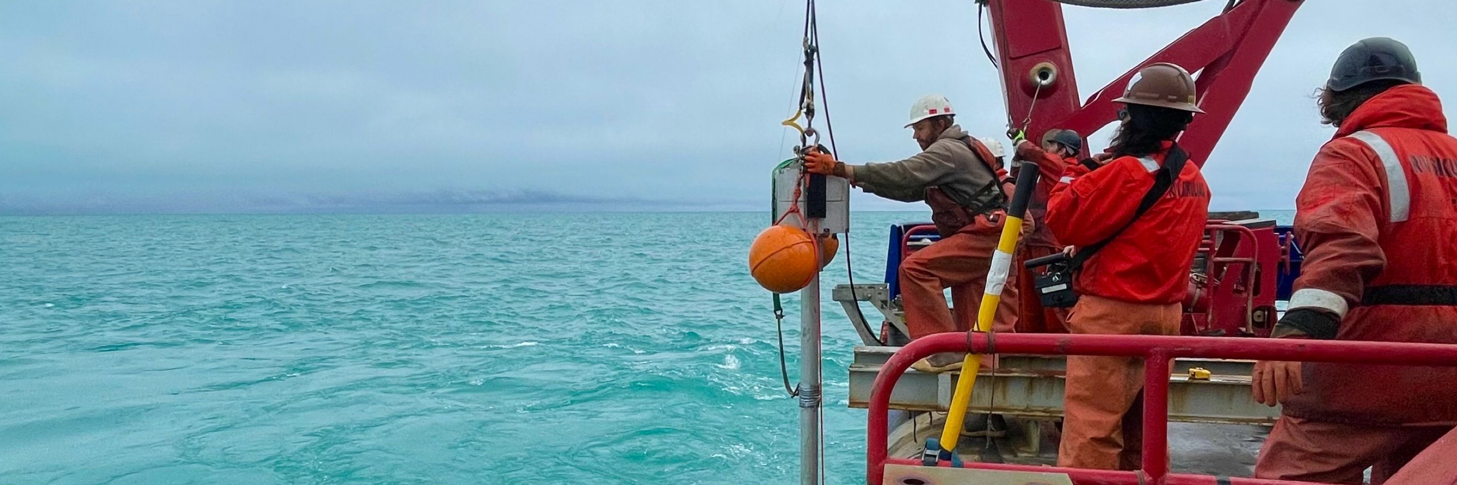
Our research team from USGS & MBARI used autonomous underwater& remotely operated vehicles to collect detailed seafloor bathymetry, sediment cores and subbottom data. Together, these data allow us to examine the shape of the seafloor and the layers of sediment beneath that record earth history. 🧪⚒️🌊

January 14, 2026 at 9:31 PM
Our research team from USGS & MBARI used autonomous underwater& remotely operated vehicles to collect detailed seafloor bathymetry, sediment cores and subbottom data. Together, these data allow us to examine the shape of the seafloor and the layers of sediment beneath that record earth history. 🧪⚒️🌊
Our new paper on earthquake records in the Cascadia Subduction Zone is out today!
The goal of our work is to reduce uncertainty in the timing and frequency of large earthquakes by investigating how and where subduction earthquake-triggered deposits are formed. 🧪⚒️🌊
www.science.org/doi/10.1126/...
The goal of our work is to reduce uncertainty in the timing and frequency of large earthquakes by investigating how and where subduction earthquake-triggered deposits are formed. 🧪⚒️🌊
www.science.org/doi/10.1126/...

Widespread abyssal turbidites record megathrust earthquake-triggered landslides and coseismic deformation in the Cascadia subduction zone
Lower slope failures produce abyssal turbidites that record shaking and coseismic deformation during megathrust earthquakes.
www.science.org
January 14, 2026 at 9:31 PM
Our new paper on earthquake records in the Cascadia Subduction Zone is out today!
The goal of our work is to reduce uncertainty in the timing and frequency of large earthquakes by investigating how and where subduction earthquake-triggered deposits are formed. 🧪⚒️🌊
www.science.org/doi/10.1126/...
The goal of our work is to reduce uncertainty in the timing and frequency of large earthquakes by investigating how and where subduction earthquake-triggered deposits are formed. 🧪⚒️🌊
www.science.org/doi/10.1126/...
😆 Indeed! Don’t worry, we’ve had plenty of rain/fog days too!
December 20, 2025 at 3:07 AM
😆 Indeed! Don’t worry, we’ve had plenty of rain/fog days too!
⚒️🧪🌊Check out some sweet footage of our Alaska work for #FieldworkFriday:
fb.watch/E5OENYnwwA/?...
(Alas USGS is not on BlueSky 🦋 so you’ll have to check it out elsewhere)
fb.watch/E5OENYnwwA/?...
(Alas USGS is not on BlueSky 🦋 so you’ll have to check it out elsewhere)
fb.watch
December 20, 2025 at 3:01 AM
⚒️🧪🌊Check out some sweet footage of our Alaska work for #FieldworkFriday:
fb.watch/E5OENYnwwA/?...
(Alas USGS is not on BlueSky 🦋 so you’ll have to check it out elsewhere)
fb.watch/E5OENYnwwA/?...
(Alas USGS is not on BlueSky 🦋 so you’ll have to check it out elsewhere)
Felt a cute little pair of shakers in Santa Cruz
November 26, 2025 at 5:49 PM
Felt a cute little pair of shakers in Santa Cruz
Copper River delta, Alaska. So much sediment!!
October 11, 2025 at 2:36 AM
Copper River delta, Alaska. So much sediment!!


New seafloor mapping offshore Alaska in the Alaska-Aleutian subduction zone! #USGS #NOAA #MarineGeohazards 🧪⚒️🌊

New seafloor mapping offshore Kodiak Island, Alaska, reveals extensive submarine landslides
In summer 2025, a research team led by the USGS worked with the NOAA ship Rainier to map a large swath of seafloor offshore of Kodiak Island, Alaska, along the Alaska-Aleutian Trench.
www.usgs.gov
August 29, 2025 at 1:17 AM
New seafloor mapping offshore Alaska in the Alaska-Aleutian subduction zone! #USGS #NOAA #MarineGeohazards 🧪⚒️🌊
Alaska Earthquake Center posted a nice explainer video with some of the video reconnaissance following the recent #landslide and #tsunami in Tracy Arm, south of Juneau, Alaska. It’s a whopper! 🧪⚒️

Early View of Tracy Arm Landslide Features
YouTube video by Alaska Earthquake Center
youtu.be
August 15, 2025 at 1:26 AM
Alaska Earthquake Center posted a nice explainer video with some of the video reconnaissance following the recent #landslide and #tsunami in Tracy Arm, south of Juneau, Alaska. It’s a whopper! 🧪⚒️
Reposted by Jenna C. Hill

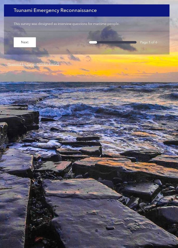
the California Geological Survey has prepared a survey to gather your observations from the M8.8 Kamchatka, Russia Tsunami
If you have been able to make any observations of the tsunami or of the evidence left behind by tsunami, we want your information:
survey123.arcgis.com/share/76979d...
If you have been able to make any observations of the tsunami or of the evidence left behind by tsunami, we want your information:
survey123.arcgis.com/share/76979d...
July 30, 2025 at 4:58 PM
the California Geological Survey has prepared a survey to gather your observations from the M8.8 Kamchatka, Russia Tsunami
If you have been able to make any observations of the tsunami or of the evidence left behind by tsunami, we want your information:
survey123.arcgis.com/share/76979d...
If you have been able to make any observations of the tsunami or of the evidence left behind by tsunami, we want your information:
survey123.arcgis.com/share/76979d...
It’s important to point out that this is because Crescent City,CA is expected to see higher wave heights due to the local topography/bathymetry and focusing of the wave energy.
July 30, 2025 at 4:10 AM
It’s important to point out that this is because Crescent City,CA is expected to see higher wave heights due to the local topography/bathymetry and focusing of the wave energy.
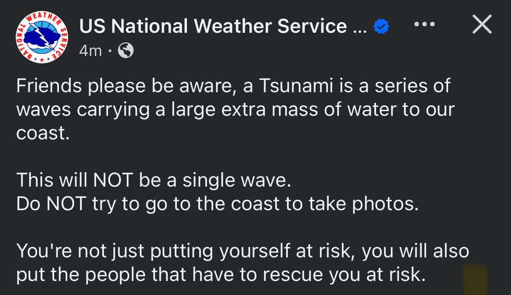
An important reminder from the US National Weather service regarding the US west coast tsunami advisories following today’s M8.8 Kamchatka quake:
July 30, 2025 at 2:36 AM
An important reminder from the US National Weather service regarding the US west coast tsunami advisories following today’s M8.8 Kamchatka quake:
The Ecosystems Mission area is a major component of the USGS Alaska Science Center, along with Earthquake, Landslide and Volcano Hazards, Energy & Minerals - these folks are hard working scientists who do great work. 🧪⚒️

The Ecosystems Office at USGS Alaska does important work for responsible resource development in Alaska & more people should know about their role in supporting our economy.
Their mission is worthy of continued federal funding
www.usgs.gov/centers/alas...
Their mission is worthy of continued federal funding
www.usgs.gov/centers/alas...

Q&A: The Role of USGS Ecosystems Science in Alaska
The USGS is the science arm of the Department of the Interior (DOI) with a mission to provide timely and impartial science information to decision-makers, industry, and others. Topics of USGS research...
www.usgs.gov
June 26, 2025 at 3:33 AM
The Ecosystems Mission area is a major component of the USGS Alaska Science Center, along with Earthquake, Landslide and Volcano Hazards, Energy & Minerals - these folks are hard working scientists who do great work. 🧪⚒️
“NPR reached out to the Office of Management and Budget to confirm the planned cut. In an email, a spokesperson replied, the EMA is, quote, "obviously irrelevant to science and is exactly the kind of waste President Trump ran on rooting out of the federal government."”
🧪⚒️
🧪⚒️
June 20, 2025 at 4:39 PM
“NPR reached out to the Office of Management and Budget to confirm the planned cut. In an email, a spokesperson replied, the EMA is, quote, "obviously irrelevant to science and is exactly the kind of waste President Trump ran on rooting out of the federal government."”
🧪⚒️
🧪⚒️