


Andrew Macklin - WX
@amacklin10.bsky.social
Storm Chasing + Drone Videography 🌩🌪🏞🏔🇨🇦 | Hiking | Scuba | Biochemist | Northern Tornados Project Super Contributor
Ottawa - ON
Ottawa - ON
Pinned

ChaseON 2020: Southern Ontario's Storm Season
YouTube video by Andrew Macklin
youtu.be
(1/2) Here it is: CHASE ONtario 2020 🚗🌪️⛈️🇨🇦
30 hrs of storm footage📹
100 hrs of editing💻
Shrunk down to 4mins 👀
Intro: 0:00-1:38
Ground Footage: 1:38 - 2:50
Aerial Footage: 2:50-4:13 including the Glencoe and Oxford Mills tornados
#onwx #ONStorm
youtu.be/UYQJOTT0thQ?...
30 hrs of storm footage📹
100 hrs of editing💻
Shrunk down to 4mins 👀
Intro: 0:00-1:38
Ground Footage: 1:38 - 2:50
Aerial Footage: 2:50-4:13 including the Glencoe and Oxford Mills tornados
#onwx #ONStorm
youtu.be/UYQJOTT0thQ?...
Reposted by Andrew Macklin - WX

Non-zero tornado threat over central parts of southern ON with this convective line developing now. I've found that the SPC Mesonanalysis 'tornadic tilting and stretching parameter' seems to work well in such situations. And it's showing enhanced potential. Will be keeping an eye on this... #ONstorm

October 19, 2025 at 4:42 PM
Non-zero tornado threat over central parts of southern ON with this convective line developing now. I've found that the SPC Mesonanalysis 'tornadic tilting and stretching parameter' seems to work well in such situations. And it's showing enhanced potential. Will be keeping an eye on this... #ONstorm
Reposted by Andrew Macklin - WX

I'm missing the mountains already.

August 1, 2025 at 2:21 AM
I'm missing the mountains already.
Reposted by Andrew Macklin - WX

Deskilling is real.
This is the world generative AI peddlers long for, one where people are incompetent without their service.
Don't outsource your brain to this shit. You'll regret it.
This is the world generative AI peddlers long for, one where people are incompetent without their service.
Don't outsource your brain to this shit. You'll regret it.

help my job says i have to do my job what do i do help

August 1, 2025 at 2:54 AM
Deskilling is real.
This is the world generative AI peddlers long for, one where people are incompetent without their service.
Don't outsource your brain to this shit. You'll regret it.
This is the world generative AI peddlers long for, one where people are incompetent without their service.
Don't outsource your brain to this shit. You'll regret it.
✈️ Wheels up for a 10-day vacation in northern Italy!
How long into the flight should I wait to show my wife this image of the Po Valley during peak season? I can feel the eye rolls already
How long into the flight should I wait to show my wife this image of the Po Valley during peak season? I can feel the eye rolls already

July 3, 2025 at 8:17 PM
✈️ Wheels up for a 10-day vacation in northern Italy!
How long into the flight should I wait to show my wife this image of the Po Valley during peak season? I can feel the eye rolls already
How long into the flight should I wait to show my wife this image of the Po Valley during peak season? I can feel the eye rolls already
I did alright. Wish I got there a bit earlier to properly position, but made it to Hanover just in time. My benchmark for a successful chase is getting on a tor-warned storm, so I’ll take the win, however marginal it was. I reminded myself the ceiling was unlikely to be achieved before embarking
July 2, 2025 at 12:04 AM
I did alright. Wish I got there a bit earlier to properly position, but made it to Hanover just in time. My benchmark for a successful chase is getting on a tor-warned storm, so I’ll take the win, however marginal it was. I reminded myself the ceiling was unlikely to be achieved before embarking
I saw your dot just to my north from Hanover and was hoping to see your POV of the rotation. Impressive that you were able to record it amongst the mush! (which a very accurate descriptor)
July 1, 2025 at 4:15 AM
I saw your dot just to my north from Hanover and was hoping to see your POV of the rotation. Impressive that you were able to record it amongst the mush! (which a very accurate descriptor)
Hold up, there is a peculiarity in the footage with boosted contrast. This slender elephant-trunk-looking feature was present for 30sec and is in the right spot to be a funnel cloud. Inflow is entering the tor-warned circulation from the right side of the photo. #onwx thoughts?

July 1, 2025 at 4:03 AM
Hold up, there is a peculiarity in the footage with boosted contrast. This slender elephant-trunk-looking feature was present for 30sec and is in the right spot to be a funnel cloud. Inflow is entering the tor-warned circulation from the right side of the photo. #onwx thoughts?
Some great lightning from the weekend's SW Ontario chase! This is from the backside of the decaying tornado-warned circulation.
It was great to return to the area (first chase there since 2020) and arrive *just* in time for the action.
#onwx
It was great to return to the area (first chase there since 2020) and arrive *just* in time for the action.
#onwx
July 1, 2025 at 3:37 AM
Some great lightning from the weekend's SW Ontario chase! This is from the backside of the decaying tornado-warned circulation.
It was great to return to the area (first chase there since 2020) and arrive *just* in time for the action.
#onwx
It was great to return to the area (first chase there since 2020) and arrive *just* in time for the action.
#onwx
The tornado-warned circulation from a couple of evenings ago in SW Ontario. The drone recorded the storm circulation for +20mins and it did not indicate any touchdowns (even with boosted contrast). Tricky when the circulation was often obscured by heavy rain #onwx

July 1, 2025 at 3:37 AM
The tornado-warned circulation from a couple of evenings ago in SW Ontario. The drone recorded the storm circulation for +20mins and it did not indicate any touchdowns (even with boosted contrast). Tricky when the circulation was often obscured by heavy rain #onwx
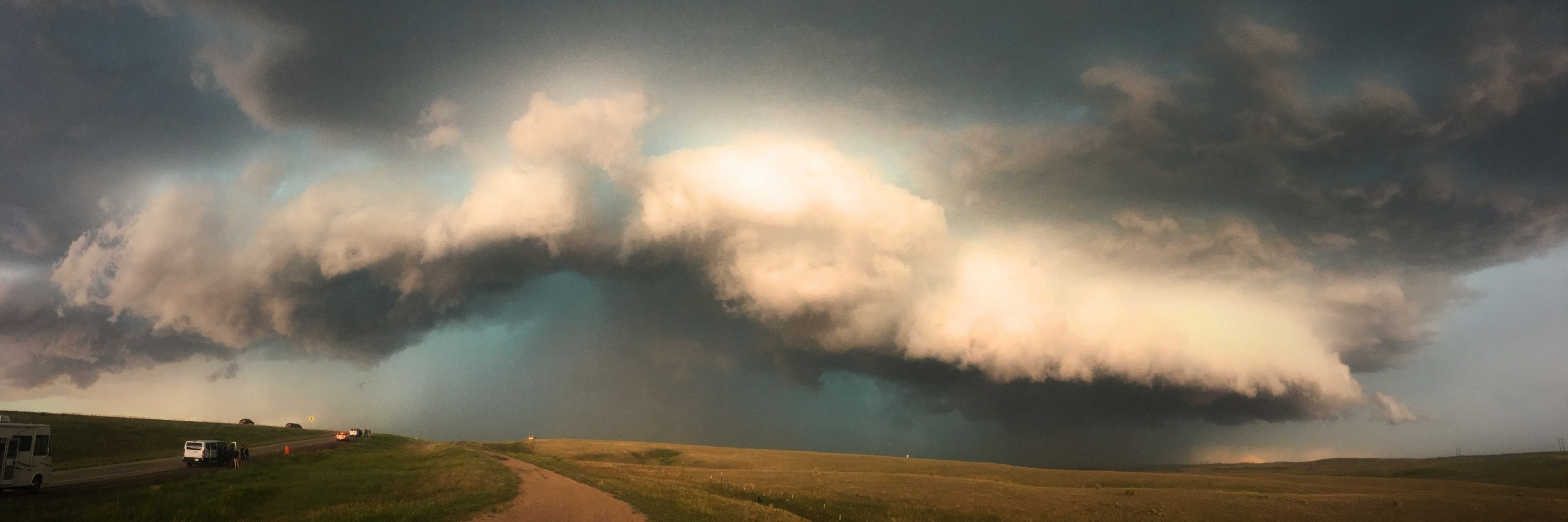
Beautiful shelf passing north of Hanover from a couple of nights ago. This is looking northwest towards Chesley where notable radar-indicated rotation was buried deep in the precipitation. #onwx
July 1, 2025 at 3:36 AM
Beautiful shelf passing north of Hanover from a couple of nights ago. This is looking northwest towards Chesley where notable radar-indicated rotation was buried deep in the precipitation. #onwx
The face of Type II joy

June 10, 2025 at 3:35 AM
The face of Type II joy
Sunday was well spent in the Adirondacks High Peak district.
Hard to believe that these views are only a four-hour drive away, and a reminder not to take them for granted. Tbh this trail kicked my ass...3500 steep feet of elevation gain over rough, untamed forest terrain
Hard to believe that these views are only a four-hour drive away, and a reminder not to take them for granted. Tbh this trail kicked my ass...3500 steep feet of elevation gain over rough, untamed forest terrain
June 10, 2025 at 3:35 AM
Sunday was well spent in the Adirondacks High Peak district.
Hard to believe that these views are only a four-hour drive away, and a reminder not to take them for granted. Tbh this trail kicked my ass...3500 steep feet of elevation gain over rough, untamed forest terrain
Hard to believe that these views are only a four-hour drive away, and a reminder not to take them for granted. Tbh this trail kicked my ass...3500 steep feet of elevation gain over rough, untamed forest terrain
From this evening. That rotating bowled lowering sure jump-started the adrenaline


May 31, 2025 at 2:45 AM
From this evening. That rotating bowled lowering sure jump-started the adrenaline
Overtime again, shocking!
May 26, 2025 at 11:41 PM
Overtime again, shocking!
Clearing is moving into Central Ontario. I won’t make it to the jungles of Haliburton-Bancroft but a safe bet for Sev Tstorms is the OTT River Valley where there is a boundary, and marginally enhanced moisture pooling/directional shear. Good chase terrain nearby in Shawville QC. Lets go

April 29, 2025 at 6:10 PM
Clearing is moving into Central Ontario. I won’t make it to the jungles of Haliburton-Bancroft but a safe bet for Sev Tstorms is the OTT River Valley where there is a boundary, and marginally enhanced moisture pooling/directional shear. Good chase terrain nearby in Shawville QC. Lets go
Trying to fold the thick ballot and stuff it into the box’s slit was a comical challenge
April 29, 2025 at 3:58 AM
Trying to fold the thick ballot and stuff it into the box’s slit was a comical challenge

Ah yes, the classic westward cutoff low moving from *check notes* Labrador to Pikes Peak...
I love model shenanigans
I love model shenanigans

April 26, 2025 at 9:38 PM
Ah yes, the classic westward cutoff low moving from *check notes* Labrador to Pikes Peak...
I love model shenanigans
I love model shenanigans
Tues chasing expectations: low, considering the narrow time window for SFC-based severe in Central Ontario. As usual with these early-season setups, the CAPE may not advect quite as far north as modelled. It's April afterall...
Tues chasing excitement: high. Because it's April?!
Tues chasing excitement: high. Because it's April?!

April 26, 2025 at 9:11 PM
Tues chasing expectations: low, considering the narrow time window for SFC-based severe in Central Ontario. As usual with these early-season setups, the CAPE may not advect quite as far north as modelled. It's April afterall...
Tues chasing excitement: high. Because it's April?!
Tues chasing excitement: high. Because it's April?!
Eclipse day was the best day ❤️
Do you have your eyes on Tuesday for storms? It reminds me of May 2 2016(?) which had a similar parameter space and and an enhanced risk, but too much shear for anything substantial to materialize beyond fast moving thundershowers through cottage country.
Do you have your eyes on Tuesday for storms? It reminds me of May 2 2016(?) which had a similar parameter space and and an enhanced risk, but too much shear for anything substantial to materialize beyond fast moving thundershowers through cottage country.
April 25, 2025 at 1:49 PM
Eclipse day was the best day ❤️
Do you have your eyes on Tuesday for storms? It reminds me of May 2 2016(?) which had a similar parameter space and and an enhanced risk, but too much shear for anything substantial to materialize beyond fast moving thundershowers through cottage country.
Do you have your eyes on Tuesday for storms? It reminds me of May 2 2016(?) which had a similar parameter space and and an enhanced risk, but too much shear for anything substantial to materialize beyond fast moving thundershowers through cottage country.
Reposted by Andrew Macklin - WX

What an unreal couple days in the Texas panhandle for chasing slow-moving tornadic supercells. This is the stuff I use my PTO for
(4th photo credit Vitor Goede)
(4th photo credit Vitor Goede)


April 25, 2025 at 1:44 AM
What an unreal couple days in the Texas panhandle for chasing slow-moving tornadic supercells. This is the stuff I use my PTO for
(4th photo credit Vitor Goede)
(4th photo credit Vitor Goede)
Beautiful mammatus and asperitas over Ottawa this morning


April 24, 2025 at 2:25 PM
Beautiful mammatus and asperitas over Ottawa this morning
I acknowledge this is a “way-too-soon” post. But hey, it’s April, and we’re jonesing for a chase.
The last few GFS runs have hinted at the season’s first substantial severe threat next week for the Canadian side of the lower Great Lakes. Keep an eye on the trough’s evolution through the weekend.
The last few GFS runs have hinted at the season’s first substantial severe threat next week for the Canadian side of the lower Great Lakes. Keep an eye on the trough’s evolution through the weekend.

April 23, 2025 at 12:19 AM
I acknowledge this is a “way-too-soon” post. But hey, it’s April, and we’re jonesing for a chase.
The last few GFS runs have hinted at the season’s first substantial severe threat next week for the Canadian side of the lower Great Lakes. Keep an eye on the trough’s evolution through the weekend.
The last few GFS runs have hinted at the season’s first substantial severe threat next week for the Canadian side of the lower Great Lakes. Keep an eye on the trough’s evolution through the weekend.
The amount of market manipulation going on right now to make his buddies rich is unprecedented and needs to be stopped
April 9, 2025 at 9:08 PM
The amount of market manipulation going on right now to make his buddies rich is unprecedented and needs to be stopped