


🦗+🗺️+💻=🤓
Bouncing in open source space between ecology and GIS
University of Ostrava & GISMentors
#geospatial #biogeography #landscapeecology #orthoptera […]
[bridged from https://ecoevo.social/@OtoKalab on the fediverse by https://fed.brid.gy/ ] ..
more
🦗+🗺️+💻=🤓
Bouncing in open source space between ecology and GIS
University of Ostrava & GISMentors
#geospatial #biogeography #landscapeecology #orthoptera […]
[bridged from https://ecoevo.social/@OtoKalab on the fediverse by https://fed.brid.gy/ ]
Reposted by Timothée Giraud, Oto Kaláb


https://cran.r-project.org/package=fastfocal
#rstats #giscience #rspatial
Reposted by Oto Kaláb


https://doi.org/10.1007/978-3-031-99665-8_10
Preprint: https://doi.org/10.48550/arXiv.2405.06559
Code: https://github.com/Nowosad/landscapemetrics_motif_2026
#landscapeecology #rspatial #gis
Reposted by David Stott, Oto Kaláb

Compose and execute GDAL workflows with pipe-friendly functions.
Learn more: https://github.com/brownag/gdalcli
#rstats #gdal #geospatial #opensource #rspatial
Reposted by Oto Kaláb
Reposted by Oto Kaláb


We’re looking for speakers. If you’d like to share your #qgis work or ideas, sign up
👉 https://github.com/qgis/QGIS/wiki/QOD-November-2025
#qod #gischat #osgeo
Reposted by Oto Kaláb


Mapy a služby v @maptiler.bsky.social anebo od od @openstreetmap k produktu
https://vhsky.cz/w/cjzDM5itV17ppVNn1xQfcw
Reposted by Oto Kaláb

If you’re using R, Python, or Julia, consider sharing open-source examples or tutorials. 🧭
https://30daymapchallenge.com/
#geodata #dataviz #maps #spatialviz
Reposted by Oto Kaláb


[Original post on techhub.social]
Reposted by Oto Kaláb

Reposted by Oto Kaláb
https://jobs.univie.ac.at/job/University-Assistant-postdoctoral/1251977001/
#gischat #giscience #GISjobs
Reposted by Oto Kaláb


“Raster really is faster (and vaster), but vector just seems more corrector.”
Part 1A of a series revisiting ideas from Geographic Information Analysis: fractals, raster vs vector, and R code.
👉 […]
[Original post on fosstodon.org]
Reposted by Oto Kaláb

Hugh Graham’s guide with vrtility in #rstats. Includes authentication & query of imagery and building cloud-free composites […]
[Original post on fosstodon.org]
Reposted by Oto Kaláb


Reposted by Oto Kaláb


Discuss how to access, process, and analyze satellite data with #rstats.
👉 https://github.com/kadyb/OGH2025
#rspatial #remotesensing #gischat
Reposted by Oto Kaláb

Coding Earth: Open Source Solutions in Physical Geography
📅 Deadline: 18 Dec 2025
🔗 journals.sagepub.com/home/ppg
#opensource #openscience #gischat #rspatial #geopython
Reposted by Oto Kaláb

http://sdss2025.spatial-data-science.net/index.html
Reposted by Oto Kaláb


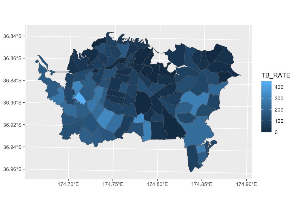
Identify & analyze spatial clusters of points (places/events) entirely with sf objects.
Includes tools for counts, change over time, kernel density, Getis–Ord Gi*, & classification.
🔗 GitHub […]
[Original post on fosstodon.org]
Reposted by Oto Kaláb
📅 Apply before 15 Sept 2025
🔗 https://stellen.uni-muenster.de/jobposting/112b1672862ecf6f36fedb4835a68b8e4b77c78e0
#remotesensing #phd […]
Reposted by Oto Kaláb


Více⬇️
www.avcr.cz/cs/pro-media...
Reposted by Oto Kaláb
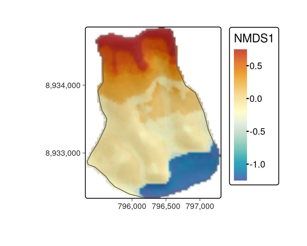
Modeling the floristic gradient to reveal distinctive vegetation belts! 📌 Learn spatial modeling techniques with random forests & hyperparameter tuning to analyze ecological data in R.
🔗 https://r.geocompx.org/eco
#rstats #rspatial #geocompx
Reposted by Oto Kaláb
https://hub.qgis.org/screenshots/?sort=upload_date&order=desc
It's a new place to share visuals that don't fit in the map gallery
#gischat #qgis
Reposted by Oto Kaláb
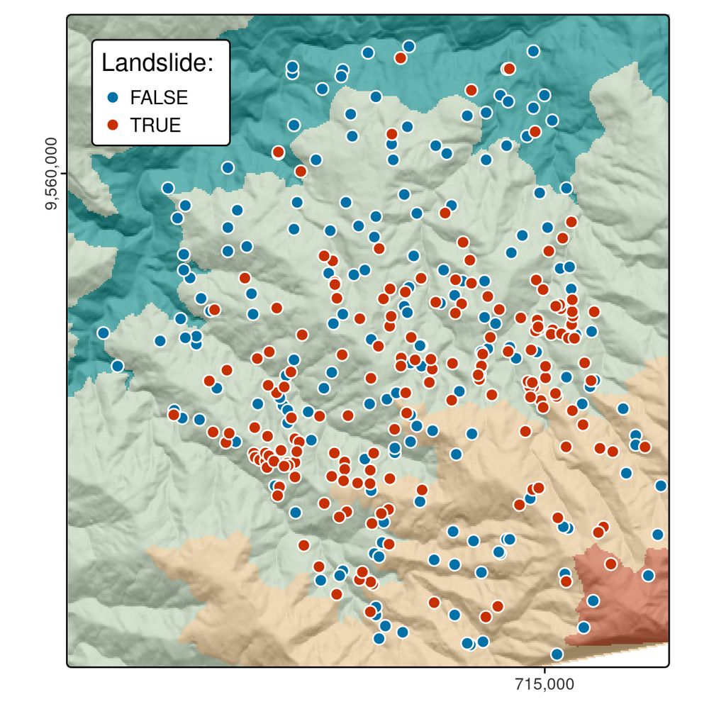
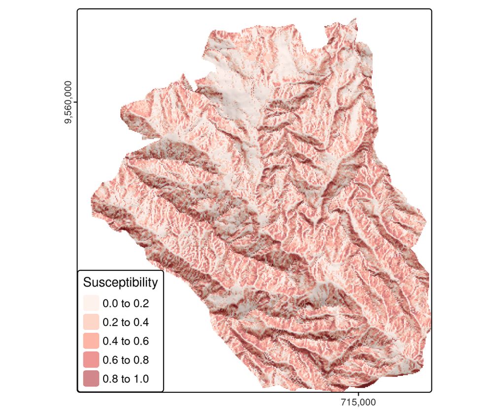
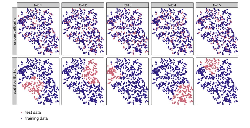
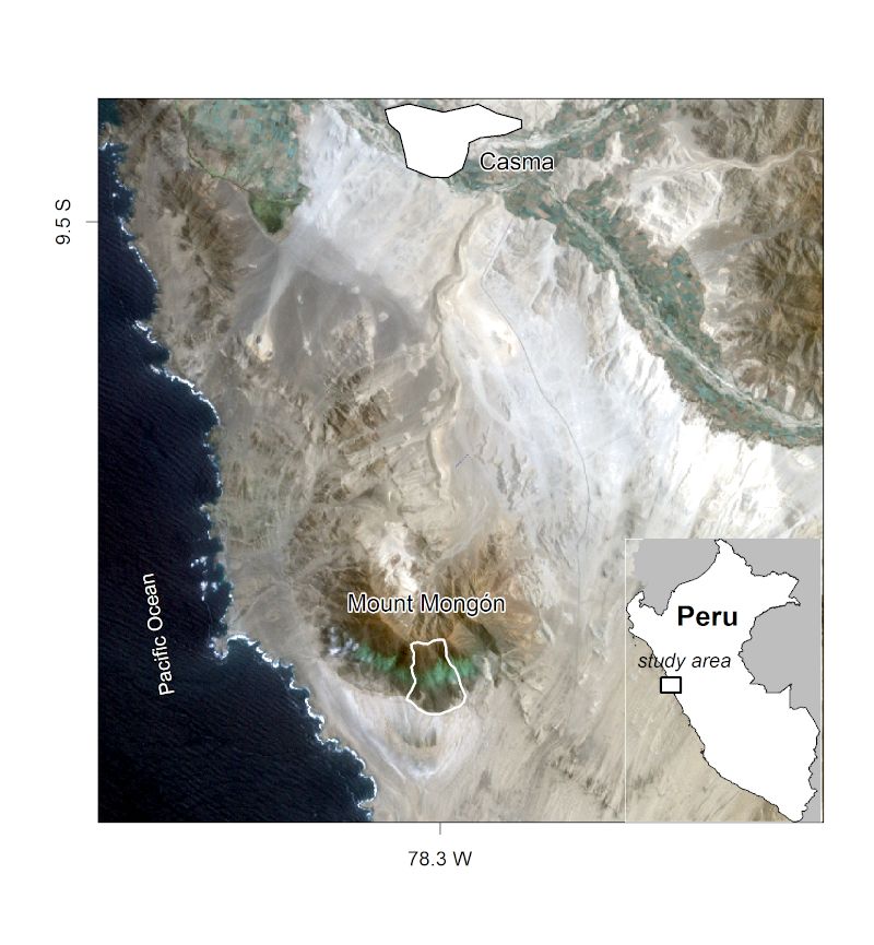
Boost your spatial models! 📌 Learn about spatial autocorrelation, cross-validation, and machine learning with `mlr3`, using a real-world landslide prediction case study.
🔗 https://r.geocompx.org/spatial-cv
#rstats #rspatial #geocompx
Reposted by Oto Kaláb
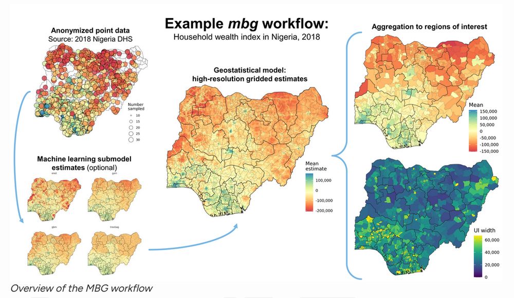
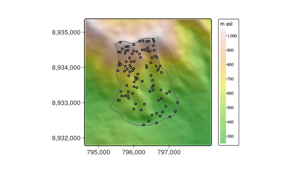
Run spatial ML & geostatistical models to estimate continuous surfaces from point data + raster covariates.
Built on sf, terra, data.table, caret, and R-INLA.
https://cran.r-project.org/package=mbg
#rspatial #rstats #geostatistics
Reposted by Oto Kaláb
Reposted by Oto Kaláb
The QGISUC2025 team has done an awesome job recording and editing the conference presentations. All "presentation" type talks where the presenter has accepted to be published are now available in a dedicated list on the QGIS Youtube channel. I also had […]
Reposted by Oto Kaláb

Reposted by Oto Kaláb

Reposted by Oto Kaláb
https://youtu.be/x3i9qyFGgcQ
#qgis #qgisuc2025 #gischat
Reposted by Oto Kaláb


This blog post by Marvin Ludwig also includes tips on autocorrelation, extrapolation & more.
🔗 https://geocompx.org/post/2025/sml-bp4/
#mlr3 #rstats #gischat #rspatial
Reposted by Oto Kaláb

Order your copy today and explore the latest in R for spatial analysis.
Learn more about the book's journey: https://buff.ly/3TZzc4L
#geocompx #rspatial #rstats #gis