


Oto Kaláb
@otokalab.ecoevo.social.ap.brid.gy
🦗+🗺️+💻=🤓
Bouncing in open source space between ecology and GIS
University of Ostrava & GISMentors
#geospatial #biogeography #landscapeecology #orthoptera […]
[bridged from https://ecoevo.social/@OtoKalab on the fediverse by https://fed.brid.gy/ ]
Bouncing in open source space between ecology and GIS
University of Ostrava & GISMentors
#geospatial #biogeography #landscapeecology #orthoptera […]
[bridged from https://ecoevo.social/@OtoKalab on the fediverse by https://fed.brid.gy/ ]
Reposted by Oto Kaláb

tmap or ggplot2 for maps? 🗺️
David O’Sullivan breaks down the trade-offs in a blog post.
URL: https://dosull.github.io/posts/2024-11-16-tmap-vs-ggplot/tmap4-vs-ggplot2.html
#rstats #rspatial #maps #tmap #ggplot2
David O’Sullivan breaks down the trade-offs in a blog post.
URL: https://dosull.github.io/posts/2024-11-16-tmap-vs-ggplot/tmap4-vs-ggplot2.html
#rstats #rspatial #maps #tmap #ggplot2
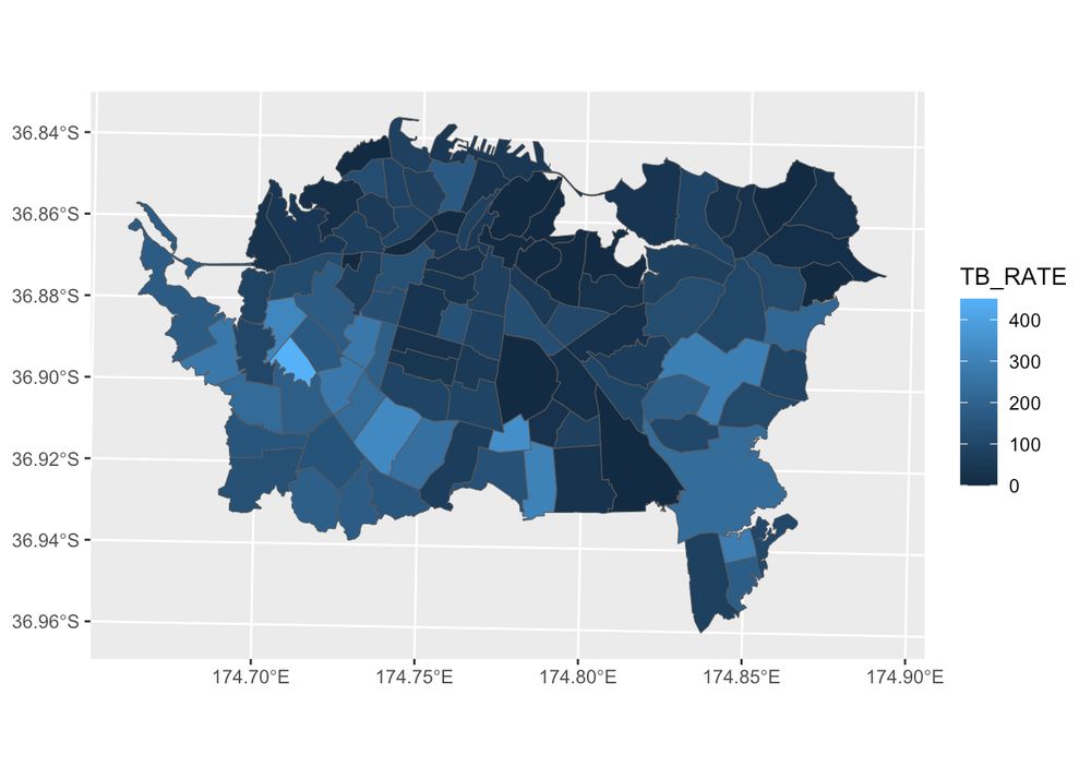
tmap vs. ggplot2 for mapping – Geospatial Stuff
For me at least the choice between ggplot2 and tmap is an ongoing question. Here are my latest thoughts on the subject (with code).
dosull.github.io
November 12, 2025 at 2:02 PM
Reposted by Oto Kaláb

We’re getting ready for QGIS Open Day on 28 November 2025! 💚
We’re looking for speakers. If you’d like to share your #qgis work or ideas, sign up
👉 https://github.com/qgis/QGIS/wiki/QOD-November-2025
#qod #gischat #osgeo
We’re looking for speakers. If you’d like to share your #qgis work or ideas, sign up
👉 https://github.com/qgis/QGIS/wiki/QOD-November-2025
#qod #gischat #osgeo

QOD November 2025
QGIS is a free, open source, cross platform (lin/win/mac) geographical information system (GIS) - qgis/QGIS
github.com
November 10, 2025 at 8:39 PM
We’re getting ready for QGIS Open Day on 28 November 2025! 💚
We’re looking for speakers. If you’d like to share your #qgis work or ideas, sign up
👉 https://github.com/qgis/QGIS/wiki/QOD-November-2025
#qod #gischat #osgeo
We’re looking for speakers. If you’d like to share your #qgis work or ideas, sign up
👉 https://github.com/qgis/QGIS/wiki/QOD-November-2025
#qod #gischat #osgeo
Reposted by Oto Kaláb

Záznam mojí přednášky z @openalt kterou pořídil tým @vhsky - moc díky
Mapy a služby v @maptiler.bsky.social anebo od od @openstreetmap k produktu
https://vhsky.cz/w/cjzDM5itV17ppVNn1xQfcw
Mapy a služby v @maptiler.bsky.social anebo od od @openstreetmap k produktu
https://vhsky.cz/w/cjzDM5itV17ppVNn1xQfcw

MapTiler mapy - zaměřeno na vývojáře, ve spolupráci s komunitou (Jachym Cepicky)
Mapy nejsou jen vizualizací dat, ale výsledkem pečlivého procesu, který propojuje otevřené databáze, jako je OpenStreetMap, komunitní spolupráci a technologickou infrastrukturu. V příspěvku předsta...
vhsky.cz
November 3, 2025 at 8:49 PM
Záznam mojí přednášky z @openalt kterou pořídil tým @vhsky - moc díky
Mapy a služby v @maptiler.bsky.social anebo od od @openstreetmap k produktu
https://vhsky.cz/w/cjzDM5itV17ppVNn1xQfcw
Mapy a služby v @maptiler.bsky.social anebo od od @openstreetmap k produktu
https://vhsky.cz/w/cjzDM5itV17ppVNn1xQfcw
Reposted by Oto Kaláb
#30DayMapChallenge starts tomorrow: 30 days, 30 map ideas.
If you’re using R, Python, or Julia, consider sharing open-source examples or tutorials. 🧭
https://30daymapchallenge.com/
#geodata #dataviz #maps #spatialviz
If you’re using R, Python, or Julia, consider sharing open-source examples or tutorials. 🧭
https://30daymapchallenge.com/
#geodata #dataviz #maps #spatialviz

30DayMapChallenge
Daily mapping challenge happening every November!
30daymapchallenge.com
October 31, 2025 at 3:03 PM
#30DayMapChallenge starts tomorrow: 30 days, 30 map ideas.
If you’re using R, Python, or Julia, consider sharing open-source examples or tutorials. 🧭
https://30daymapchallenge.com/
#geodata #dataviz #maps #spatialviz
If you’re using R, Python, or Julia, consider sharing open-source examples or tutorials. 🧭
https://30daymapchallenge.com/
#geodata #dataviz #maps #spatialviz
Reposted by Oto Kaláb

Snow cover is a crucial driver for plant species distributions in cold environments. The primary source of snow cover data used in distribution models is remotely sensed satellite imagery, which is characterized by coarser spatial resolutions than plot-scale […]
[Original post on techhub.social]
[Original post on techhub.social]

October 21, 2025 at 8:15 AM
Snow cover is a crucial driver for plant species distributions in cold environments. The primary source of snow cover data used in distribution models is remotely sensed satellite imagery, which is characterized by coarser spatial resolutions than plot-scale […]
[Original post on techhub.social]
[Original post on techhub.social]
Reposted by Oto Kaláb
TIL: apparently one of the main technical hurdles for universities to run their own #mastodon instances is to make the instance work with the institution's SSO (most often Shibboleth). It seems there would be a huge opportunity to facilitate the entrance of such major multiplicators into the […]
Original post on mastodon.social
mastodon.social
October 8, 2025 at 7:47 AM
TIL: apparently one of the main technical hurdles for universities to run their own #mastodon instances is to make the instance work with the institution's SSO (most often Shibboleth). It seems there would be a huge opportunity to facilitate the entrance of such major multiplicators into the […]
Reposted by Oto Kaláb
Postdoc in the Spatial Data Science and GeoCommunication group at @univienna
https://jobs.univie.ac.at/job/University-Assistant-postdoctoral/1251977001/
#gischat #giscience #GISjobs
https://jobs.univie.ac.at/job/University-Assistant-postdoctoral/1251977001/
#gischat #giscience #GISjobs
University Assistant postdoctoral
University Assistant postdoctoral
jobs.univie.ac.at
October 3, 2025 at 6:51 PM
Postdoc in the Spatial Data Science and GeoCommunication group at @univienna
https://jobs.univie.ac.at/job/University-Assistant-postdoctoral/1251977001/
#gischat #giscience #GISjobs
https://jobs.univie.ac.at/job/University-Assistant-postdoctoral/1251977001/
#gischat #giscience #GISjobs
Reposted by Oto Kaláb
New post by David O’Sullivan:
“Raster really is faster (and vaster), but vector just seems more corrector.”
Part 1A of a series revisiting ideas from Geographic Information Analysis: fractals, raster vs vector, and R code.
👉 […]
[Original post on fosstodon.org]
“Raster really is faster (and vaster), but vector just seems more corrector.”
Part 1A of a series revisiting ideas from Geographic Information Analysis: fractals, raster vs vector, and R code.
👉 […]
[Original post on fosstodon.org]


October 1, 2025 at 1:01 PM
New post by David O’Sullivan:
“Raster really is faster (and vaster), but vector just seems more corrector.”
Part 1A of a series revisiting ideas from Geographic Information Analysis: fractals, raster vs vector, and R code.
👉 […]
[Original post on fosstodon.org]
“Raster really is faster (and vaster), but vector just seems more corrector.”
Part 1A of a series revisiting ideas from Geographic Information Analysis: fractals, raster vs vector, and R code.
👉 […]
[Original post on fosstodon.org]
Reposted by Oto Kaláb
🌍Exploring Sentinel-2 with the Copernicus Data Space Ecosystem (CDSE)?
Hugh Graham’s guide with vrtility in #rstats. Includes authentication & query of imagery and building cloud-free composites […]
[Original post on fosstodon.org]
Hugh Graham’s guide with vrtility in #rstats. Includes authentication & query of imagery and building cloud-free composites […]
[Original post on fosstodon.org]

September 24, 2025 at 1:22 PM
🌍Exploring Sentinel-2 with the Copernicus Data Space Ecosystem (CDSE)?
Hugh Graham’s guide with vrtility in #rstats. Includes authentication & query of imagery and building cloud-free composites […]
[Original post on fosstodon.org]
Hugh Graham’s guide with vrtility in #rstats. Includes authentication & query of imagery and building cloud-free composites […]
[Original post on fosstodon.org]
Reposted by Oto Kaláb
Great discussions at #sdsl2025 about integrating #SpatialDataScience libraries in desktop and cloud environments, featuring @movingpandas , @qgis #trajectools and the @carto Trajectory Analytics extension from the @emeraldseu project


September 18, 2025 at 12:46 PM
Great discussions at #sdsl2025 about integrating #SpatialDataScience libraries in desktop and cloud environments, featuring @movingpandas , @qgis #trajectools and the @carto Trajectory Analytics extension from the @emeraldseu project
Reposted by Oto Kaláb
📢 Materials from the OpenGeoHub Summer School 2025 (“Data Science for Earth Observation”) by Krzysztof Dyba are now online.
Discuss how to access, process, and analyze satellite data with #rstats.
👉 https://github.com/kadyb/OGH2025
#rspatial #remotesensing #gischat
Discuss how to access, process, and analyze satellite data with #rstats.
👉 https://github.com/kadyb/OGH2025
#rspatial #remotesensing #gischat


September 10, 2025 at 2:01 PM
📢 Materials from the OpenGeoHub Summer School 2025 (“Data Science for Earth Observation”) by Krzysztof Dyba are now online.
Discuss how to access, process, and analyze satellite data with #rstats.
👉 https://github.com/kadyb/OGH2025
#rspatial #remotesensing #gischat
Discuss how to access, process, and analyze satellite data with #rstats.
👉 https://github.com/kadyb/OGH2025
#rspatial #remotesensing #gischat
Reposted by Oto Kaláb
🌍 Call for Papers! Submit to the Progress in Physical Geography special issue:
Coding Earth: Open Source Solutions in Physical Geography
📅 Deadline: 18 Dec 2025
🔗 journals.sagepub.com/home/ppg
#opensource #openscience #gischat #rspatial #geopython
Coding Earth: Open Source Solutions in Physical Geography
📅 Deadline: 18 Dec 2025
🔗 journals.sagepub.com/home/ppg
#opensource #openscience #gischat #rspatial #geopython

September 7, 2025 at 2:01 PM
🌍 Call for Papers! Submit to the Progress in Physical Geography special issue:
Coding Earth: Open Source Solutions in Physical Geography
📅 Deadline: 18 Dec 2025
🔗 journals.sagepub.com/home/ppg
#opensource #openscience #gischat #rspatial #geopython
Coding Earth: Open Source Solutions in Physical Geography
📅 Deadline: 18 Dec 2025
🔗 journals.sagepub.com/home/ppg
#opensource #openscience #gischat #rspatial #geopython
Reposted by Oto Kaláb
Spatial Data Science Symposium 2025 is announced. Check it out, it's hybrid!
http://sdss2025.spatial-data-science.net/index.html
http://sdss2025.spatial-data-science.net/index.html

Spatial Data Science Symposium 2025
December 4-5 | Distributed & Online. The symposium aims to bring together researchers from both academia and industry to discuss experiences, insights, methodologies, and applications, taking spatial and temporal knowledge into account while addressing their domain-specific problems.
sdss2025.spatial-data-science.net
August 29, 2025 at 7:27 AM
Spatial Data Science Symposium 2025 is announced. Check it out, it's hybrid!
http://sdss2025.spatial-data-science.net/index.html
http://sdss2025.spatial-data-science.net/index.html
Reposted by Oto Kaláb
📦 New R package: sfhotspot by Matt Ashby
Identify & analyze spatial clusters of points (places/events) entirely with sf objects.
Includes tools for counts, change over time, kernel density, Getis–Ord Gi*, & classification.
🔗 GitHub […]
[Original post on fosstodon.org]
Identify & analyze spatial clusters of points (places/events) entirely with sf objects.
Includes tools for counts, change over time, kernel density, Getis–Ord Gi*, & classification.
🔗 GitHub […]
[Original post on fosstodon.org]


August 27, 2025 at 2:01 PM
📦 New R package: sfhotspot by Matt Ashby
Identify & analyze spatial clusters of points (places/events) entirely with sf objects.
Includes tools for counts, change over time, kernel density, Getis–Ord Gi*, & classification.
🔗 GitHub […]
[Original post on fosstodon.org]
Identify & analyze spatial clusters of points (places/events) entirely with sf objects.
Includes tools for counts, change over time, kernel density, Getis–Ord Gi*, & classification.
🔗 GitHub […]
[Original post on fosstodon.org]
Reposted by Oto Kaláb

🍄 Mykologové z @ibotcz.bsky.social objevili a vědecky popsali dva nové rody mikroskopických hub, které žijí v prostředí s vysokým obsahem soli – v mořské trávě u Mauricia a ve slané půdě v západních Čechách.
Více⬇️
www.avcr.cz/cs/pro-media...
Více⬇️
www.avcr.cz/cs/pro-media...

August 15, 2025 at 4:45 PM
🍄 Mykologové z @ibotcz.bsky.social objevili a vědecky popsali dva nové rody mikroskopických hub, které žijí v prostředí s vysokým obsahem soli – v mořské trávě u Mauricia a ve slané půdě v západních Čechách.
Více⬇️
www.avcr.cz/cs/pro-media...
Více⬇️
www.avcr.cz/cs/pro-media...
Reposted by Oto Kaláb
🚀 From soil to space (and back) : PhD position using satellites & ML to study peatland carbon flux. Based in Münster, with research stays in Enschede.
📅 Apply before 15 Sept 2025
🔗 https://stellen.uni-muenster.de/jobposting/112b1672862ecf6f36fedb4835a68b8e4b77c78e0
#remotesensing #phd […]
📅 Apply before 15 Sept 2025
🔗 https://stellen.uni-muenster.de/jobposting/112b1672862ecf6f36fedb4835a68b8e4b77c78e0
#remotesensing #phd […]
Original post on fosstodon.org
fosstodon.org
August 18, 2025 at 2:02 PM
🚀 From soil to space (and back) : PhD position using satellites & ML to study peatland carbon flux. Based in Münster, with research stays in Enschede.
📅 Apply before 15 Sept 2025
🔗 https://stellen.uni-muenster.de/jobposting/112b1672862ecf6f36fedb4835a68b8e4b77c78e0
#remotesensing #phd […]
📅 Apply before 15 Sept 2025
🔗 https://stellen.uni-muenster.de/jobposting/112b1672862ecf6f36fedb4835a68b8e4b77c78e0
#remotesensing #phd […]
Reposted by Oto Kaláb
Chapter 15: Ecological Modeling & Geocomputation 🌱🗺️
Modeling the floristic gradient to reveal distinctive vegetation belts! 📌 Learn spatial modeling techniques with random forests & hyperparameter tuning to analyze ecological data in R.
🔗 https://r.geocompx.org/eco
#rstats #rspatial #geocompx
Modeling the floristic gradient to reveal distinctive vegetation belts! 📌 Learn spatial modeling techniques with random forests & hyperparameter tuning to analyze ecological data in R.
🔗 https://r.geocompx.org/eco
#rstats #rspatial #geocompx
August 3, 2025 at 4:01 PM
Chapter 15: Ecological Modeling & Geocomputation 🌱🗺️
Modeling the floristic gradient to reveal distinctive vegetation belts! 📌 Learn spatial modeling techniques with random forests & hyperparameter tuning to analyze ecological data in R.
🔗 https://r.geocompx.org/eco
#rstats #rspatial #geocompx
Modeling the floristic gradient to reveal distinctive vegetation belts! 📌 Learn spatial modeling techniques with random forests & hyperparameter tuning to analyze ecological data in R.
🔗 https://r.geocompx.org/eco
#rstats #rspatial #geocompx
Reposted by Oto Kaláb
The new :qgis: @qgis screenshot gallery is ready for you contributions!
https://hub.qgis.org/screenshots/?sort=upload_date&order=desc
It's a new place to share visuals that don't fit in the map gallery
#gischat #qgis
https://hub.qgis.org/screenshots/?sort=upload_date&order=desc
It's a new place to share visuals that don't fit in the map gallery
#gischat #qgis
QGIS Screenshot
hub.qgis.org
July 16, 2025 at 7:09 PM
The new :qgis: @qgis screenshot gallery is ready for you contributions!
https://hub.qgis.org/screenshots/?sort=upload_date&order=desc
It's a new place to share visuals that don't fit in the map gallery
#gischat #qgis
https://hub.qgis.org/screenshots/?sort=upload_date&order=desc
It's a new place to share visuals that don't fit in the map gallery
#gischat #qgis
Reposted by Oto Kaláb
Chapter 12: Spatial Statistical Learning 📊🌍
Boost your spatial models! 📌 Learn about spatial autocorrelation, cross-validation, and machine learning with `mlr3`, using a real-world landslide prediction case study.
🔗 https://r.geocompx.org/spatial-cv
#rstats #rspatial #geocompx
Boost your spatial models! 📌 Learn about spatial autocorrelation, cross-validation, and machine learning with `mlr3`, using a real-world landslide prediction case study.
🔗 https://r.geocompx.org/spatial-cv
#rstats #rspatial #geocompx
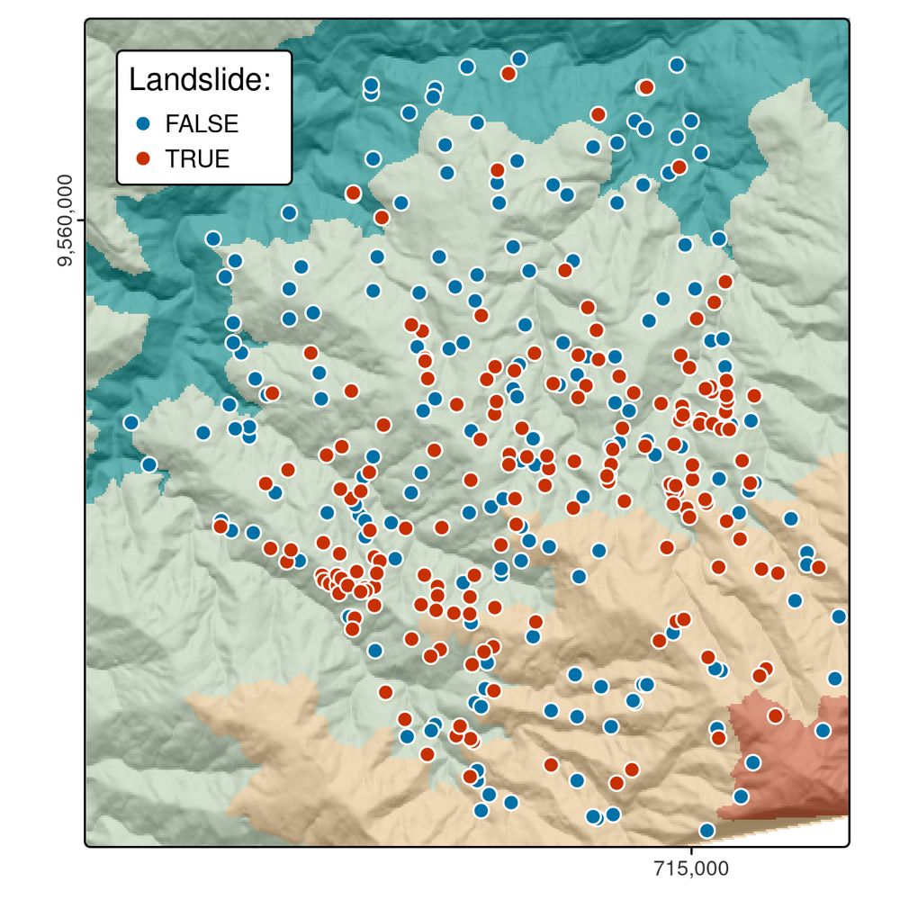
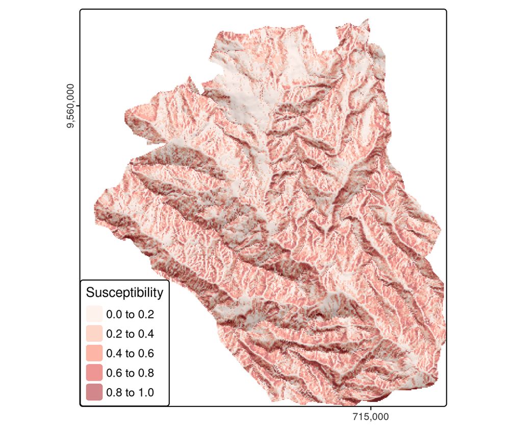
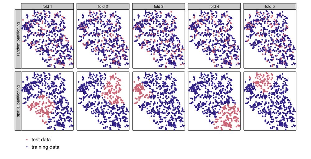
July 13, 2025 at 3:01 PM
Chapter 12: Spatial Statistical Learning 📊🌍
Boost your spatial models! 📌 Learn about spatial autocorrelation, cross-validation, and machine learning with `mlr3`, using a real-world landslide prediction case study.
🔗 https://r.geocompx.org/spatial-cv
#rstats #rspatial #geocompx
Boost your spatial models! 📌 Learn about spatial autocorrelation, cross-validation, and machine learning with `mlr3`, using a real-world landslide prediction case study.
🔗 https://r.geocompx.org/spatial-cv
#rstats #rspatial #geocompx
Reposted by Oto Kaláb
New R package alert: 📦 mbg for model-based geostatistics
Run spatial ML & geostatistical models to estimate continuous surfaces from point data + raster covariates.
Built on sf, terra, data.table, caret, and R-INLA.
https://cran.r-project.org/package=mbg
#rspatial #rstats #geostatistics
Run spatial ML & geostatistical models to estimate continuous surfaces from point data + raster covariates.
Built on sf, terra, data.table, caret, and R-INLA.
https://cran.r-project.org/package=mbg
#rspatial #rstats #geostatistics
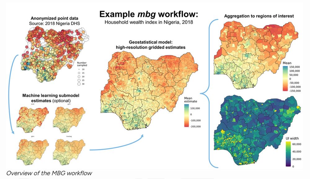
July 10, 2025 at 2:06 PM
New R package alert: 📦 mbg for model-based geostatistics
Run spatial ML & geostatistical models to estimate continuous surfaces from point data + raster covariates.
Built on sf, terra, data.table, caret, and R-INLA.
https://cran.r-project.org/package=mbg
#rspatial #rstats #geostatistics
Run spatial ML & geostatistical models to estimate continuous surfaces from point data + raster covariates.
Built on sf, terra, data.table, caret, and R-INLA.
https://cran.r-project.org/package=mbg
#rspatial #rstats #geostatistics
Reposted by Oto Kaláb
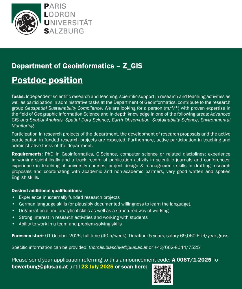
#postdoc position in #giscience at @zgis.bsky.social
Details: https://www.plus.ac.at/geoinformatik/news/
#GISjobs #salzburg
Details: https://www.plus.ac.at/geoinformatik/news/
#GISjobs #salzburg
July 4, 2025 at 5:32 PM
#postdoc position in #giscience at @zgis.bsky.social
Details: https://www.plus.ac.at/geoinformatik/news/
#GISjobs #salzburg
Details: https://www.plus.ac.at/geoinformatik/news/
#GISjobs #salzburg
Reposted by Oto Kaláb
QGIS User Conf 2025 videos have landed!
The QGISUC2025 team has done an awesome job recording and editing the conference presentations. All "presentation" type talks where the presenter has accepted to be published are now available in a dedicated list on the QGIS Youtube channel. I also had […]
The QGISUC2025 team has done an awesome job recording and editing the conference presentations. All "presentation" type talks where the presenter has accepted to be published are now available in a dedicated list on the QGIS Youtube channel. I also had […]
Original post on fosstodon.org
fosstodon.org
June 25, 2025 at 6:39 PM
QGIS User Conf 2025 videos have landed!
The QGISUC2025 team has done an awesome job recording and editing the conference presentations. All "presentation" type talks where the presenter has accepted to be published are now available in a dedicated list on the QGIS Youtube channel. I also had […]
The QGISUC2025 team has done an awesome job recording and editing the conference presentations. All "presentation" type talks where the presenter has accepted to be published are now available in a dedicated list on the QGIS Youtube channel. I also had […]
Reposted by Oto Kaláb
#giscience jobs: phd position at @unigis_salzburg
https://www.plus.ac.at/personalabteilung-amt-der-universitaet/jobs/wissenschaftliches-universitaetspersonal/dissertantin-am-fachbereich-geoinformatik-z_gis/
#gischat #GISjobs
https://www.plus.ac.at/personalabteilung-amt-der-universitaet/jobs/wissenschaftliches-universitaetspersonal/dissertantin-am-fachbereich-geoinformatik-z_gis/
#gischat #GISjobs

Dissertant*in am Fachbereich Geoinformatik – Z_GIS - Paris Lodron Universität Salzburg
Am Fachbereich Geoinformatik – Z_GIS gelangt die Stelle wissenschaftliche*r Mitarbeiter*in im Forschungs- und Lehrbetrieb gemäß UG und Angestelltengesetz als Universitätsassistent*in gem. § 26 Kollektivvertrag der Universitäten (Dissertant*in) zur Besetzung. (Verwendungsgruppe B1; das monatliche Mindestentgelt für diese Verwendung beträgt € 2.786,10 brutto (14× jährlich) und kann sich auf Basis der kollektivvertraglichen Vorschriften durch die Anrechnung tätigkeitsspezifischer
www.plus.ac.at
June 23, 2025 at 6:27 PM
Reposted by Oto Kaláb
#gisjob at Uni Twente: https://utwentecareers.nl/en/vacancies/2140/phd-candidate-in-explainable-ai-for-earth-observation/
#xai #GeoAI #gischat
#xai #GeoAI #gischat

PhD Candidate in Explainable AI for Earth Observation - Looking for a job that matters?
With the growing integration of Artificial Intelligence (AI) in geospatial decision-making processes, ensuring transparency, accountability, and trust in model outputs has become imperative, especially in critical domains such as disaster risk management,…
utwentecareers.nl
June 18, 2025 at 5:20 PM
Reposted by Oto Kaláb
Check out @spatialthoughts's "QGIS Expressions Masterclass" workshop. This was first presented at the QGIS Conference 2025 in Sweden and now made available on his channel
https://youtu.be/x3i9qyFGgcQ
#qgis #qgisuc2025 #gischat
https://youtu.be/x3i9qyFGgcQ
#qgis #qgisuc2025 #gischat
June 13, 2025 at 7:52 PM
Check out @spatialthoughts's "QGIS Expressions Masterclass" workshop. This was first presented at the QGIS Conference 2025 in Sweden and now made available on his channel
https://youtu.be/x3i9qyFGgcQ
#qgis #qgisuc2025 #gischat
https://youtu.be/x3i9qyFGgcQ
#qgis #qgisuc2025 #gischat