Duncan Smith
banner
citygeographics.bsky.social
Duncan Smith
@citygeographics.bsky.social

Urban geographer and Associate Professor in GIS & Visualisation at @casaucl.bsky.social. Blogs at https://citygeographics.org

Computer science 31%
Mathematics 13%

Reposted by Duncan Smith

Last week I presented my doctoral study about digital participation in Jakarta at 4th Digital Geographies Conference in Lisbon. My presentation was included in Special Session 5 - Putting Information into Spatial Structures: Approaches in Localising Information and Knowledge.

These measures are weighted by centrality, so the roads that cyclists want to use to reach typical destinations count for more than infrequently used routes. See working paper. This research is part of the ENHANCE project, @casaucl.bsky.social www.ucl.ac.uk/bartlett/res...
ENHANCE: Enhancing Sustainable Travel in Regional Cities and Outer Metropolitan Areas
This ESRC-funded project explores how 15-minute city principles can be adapted to support sustainable travel in regional towns and outer metropolitan areas across Europe.
www.ucl.ac.uk

In the overall combined score, Hackney, Islington, Hammersmith & Lewisham are the best Inner boroughs; and Waltham Forest, Richmond and Haringey are the best Outer. Kensington & Chelsea is the worst Inner borough, while there are lots of car-dependent poorly performing Outer London boroughs-

The second perspective is Level of Traffic Stress, which measures general road conditions for cycling such as speed limits and road type. Low speed Inner London boroughs with Low Traffic Neighbourhoods and similar infrastructure do best here, such as Hackney and Islington-

We combine two perspectives on cycle networks. The first is infrastructure, measuring the presence and quality of cycle lanes, with priority to physically segregated lanes. Outer London boroughs that have invested in cycling do well in this measure (Waltham Forest, Richmond)-

Which London boroughs are the best for cycling? We’ve been working on developing new open data indicators of cycle network quality-
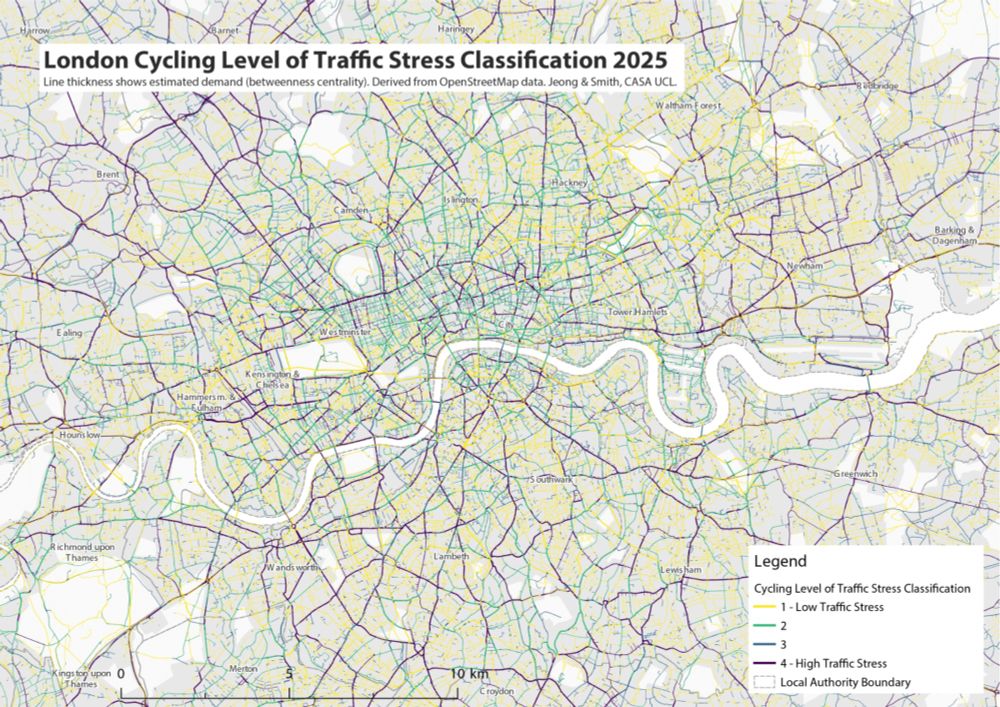
citygeographics.org/2025/11/07/d...
Improving Indicators of Urban Cycle Network Quality: a Case Study of London Boroughs
Increasing levels of cycling is a key part of the transport strategies of many global cities with the potential for significant health and sustainability benefits. Many urban cycle networks are how…
citygeographics.org

Reposted by Duncan Smith

It’s been long overdue (~1 month!) but I presented my initial findings in Social Media Geopolitics session at #AAG2025 in Detroit last month—all thanks to @casaucl.bsky.social Doctoral Student Conference Fund. My study revolves on digital participation in Jakarta, using government-app called Qlue.

Reposted by Duncan Smith

🧱 | NEW REPORT: Instead of stripping back planning regulations to 'get Britain building,' this new report from @msingerhobbs.bsky.social argues we need a stronger, better resourced, planning system.
Strategic planning for green prosperity | IPPR
Not only do we need to house and feed more people, but also provide space for energy generation, areas for nature, places for climate mitigation, room for
www.ippr.org

Reposted by Duncan Smith

In the next Economic Geography Network Seminar, Deivi Norberg (UCL/QMUL) shares her research into how small businesses have used community organising to resist rising commercial rents & displacement.

🗓️ 17:00, Mon 09 December
📍 CASA Seminar Room 106/107

www.ucl.ac.uk/bartlett/cas...

Reposted by Duncan Smith

NEW REPORTS | Restarting housebuilding🏘️

These new reports focus on private and public housebuilding, using local-level data from the last 80 years to analyse the reforms needed to meet the government's 1.5m housebuilding target.

Read the full reports👇
www.centreforcities.org/housing/
The housing crisis - Centre for Cities
The UK doesn’t have a national housing crisis, but there is a housing crisis in our most unaffordable cities. How can homes be built where they are needed?
www.centreforcities.org

Reposted by Duncan Smith

REVEALED: Just 2,500 farms own a QUARTER of the farmland in England

Startling new stats I obtained from DEFRA & shared with @mirror.co.uk show how unequal land ownership is in this country

Large landowners must pay their fair share of tax
🧵 1/

www.mirror.co.uk/news/politic...

Reposted by Duncan Smith

Today I ventured south to Glen Shee, in search of hilltop sunshine. Turns out my choice of hill, Creag Leacach, was right on the dividing line between fog and sun. This made for spectacular cloudscapes throughout the day, changing every few minutes 🙂

Reposted by Duncan Smith

Reposted by Duncan Smith

Bits #4K Review – @billhuntbits.bsky.social reviews Akira Kurosawa’s legendary epic SEVEN SAMURAI (1954) in a lovely new #UltraHD release from @criterion.bsky.social !
thedigitalbits.com/item/seven-s...

Reposted by Duncan Smith

🚀 Job Alert!!! 🚀 The first in a series of long term posts within the SDRUK Geographic Data Service which will launch next year -this one is based in London - https://buff.ly/4fSyChU and builds on the work that we have done over the past ten years as part of the CDRC.

Reposted by Duncan Smith

A short thread on the data used in the NEF report on car dependency by me and Emmet Kiberd, released yesterday. The report looks at the exact locations of all new homes in England, and shows that they are being built in increasingly car dependent areas. 1/4

Super useful list of planning and housing accounts to follow on bluesky by @barneystringer.bsky.social -

New open access paper - can we develop London's Green Belt sustainably to tackle the housing crisis? Analysis using EPC and travel sustainability data -
www.sciencedirect.com/science/arti... @casaucl.bsky.social

Reposted by Duncan Smith

Highlights from the @neweconomics.bsky.social report on car dependency. The report shows that new homes in England are increasingly located in car dependent areas with poor transport infrastructure. The triangle in the figure indicates car dependency of median home from each period. 1/6