


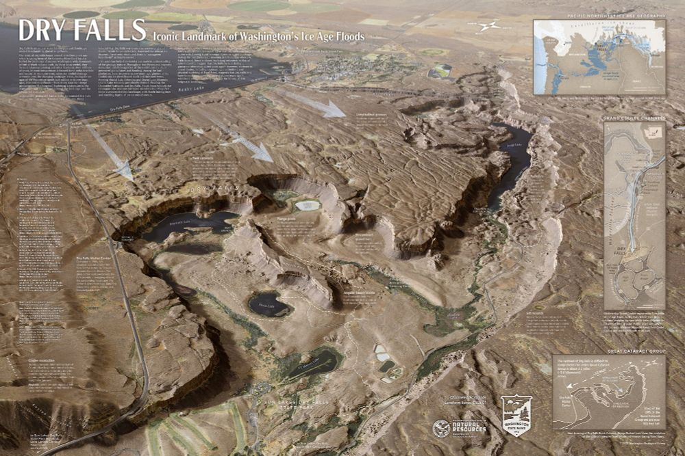
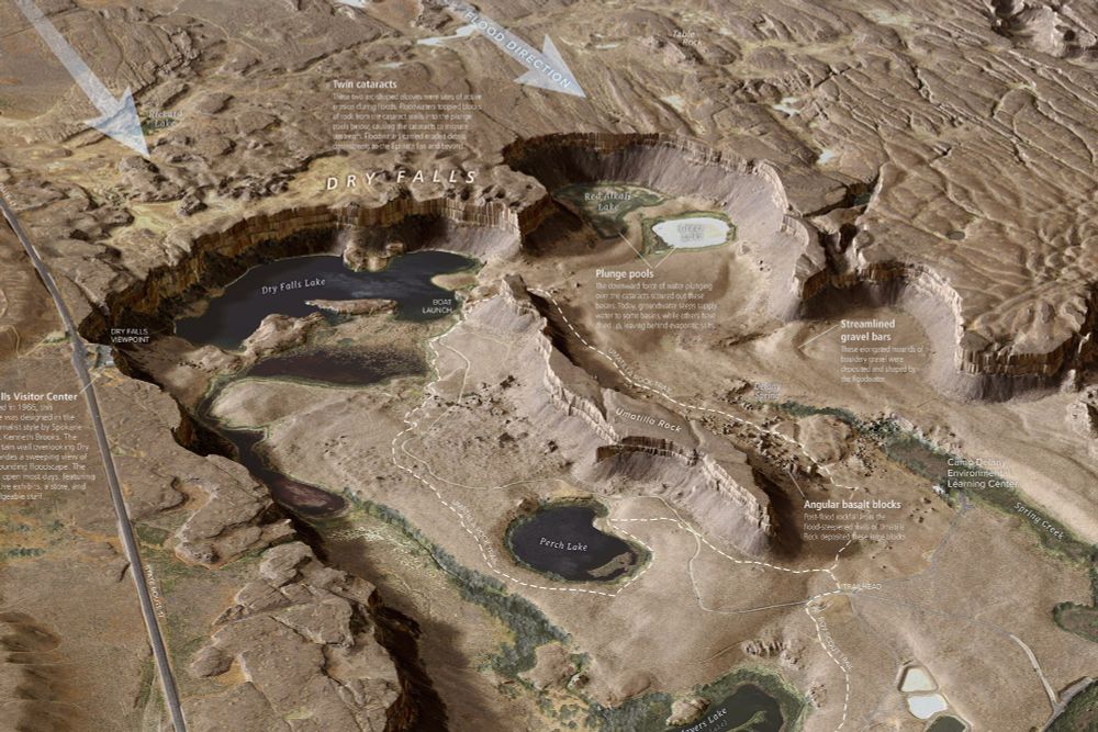
New, super-detailed Dry Falls interpretive map from the Washington Geological Survey. #iceagefloods #missoulafloods #channeledscablands #geomorphology washingtonstategeology.wordpress.com/2025/07/15/n...
July 23, 2025 at 4:26 AM
New, super-detailed Dry Falls interpretive map from the Washington Geological Survey. #iceagefloods #missoulafloods #channeledscablands #geomorphology washingtonstategeology.wordpress.com/2025/07/15/n...
#palousefalls the final entry in our #channeledscablands road trip. This 200ft waterfall was also created during the big flood that created dry falls.

May 25, 2025 at 9:35 PM
#palousefalls the final entry in our #channeledscablands road trip. This 200ft waterfall was also created during the big flood that created dry falls.


May 25, 2025 at 3:46 PM
More about the big flood during the ice age: It created the #channeledscablands as it scoured part of eastern and central Washington. It left behind towers, cliffs, lakes, and hillocks of rock-similar to shapes you might see made by sand on a beach. #basalt see alt text.


May 25, 2025 at 4:46 AM
More about the big flood during the ice age: It created the #channeledscablands as it scoured part of eastern and central Washington. It left behind towers, cliffs, lakes, and hillocks of rock-similar to shapes you might see made by sand on a beach. #basalt see alt text.

Paddleboarding a lake carved by lava and glaciers?
Yes please.
Williams Lake is one of Eastern WA’s hidden gems—peaceful waters, basalt cliffs, and tons of osprey.
Catch the ride → youtu.be/OqN-WynvRU0
#SUPPNW #PNWPaddleboards #IceAgeFloods #ChanneledScablands
Yes please.
Williams Lake is one of Eastern WA’s hidden gems—peaceful waters, basalt cliffs, and tons of osprey.
Catch the ride → youtu.be/OqN-WynvRU0
#SUPPNW #PNWPaddleboards #IceAgeFloods #ChanneledScablands

Paddle Tour of Williams Lake: a Place Created by Fire and Ice 🔥+🧊
YouTube video by PNW Paddleboards
youtu.be
May 12, 2025 at 1:27 PM
Paddleboarding a lake carved by lava and glaciers?
Yes please.
Williams Lake is one of Eastern WA’s hidden gems—peaceful waters, basalt cliffs, and tons of osprey.
Catch the ride → youtu.be/OqN-WynvRU0
#SUPPNW #PNWPaddleboards #IceAgeFloods #ChanneledScablands
Yes please.
Williams Lake is one of Eastern WA’s hidden gems—peaceful waters, basalt cliffs, and tons of osprey.
Catch the ride → youtu.be/OqN-WynvRU0
#SUPPNW #PNWPaddleboards #IceAgeFloods #ChanneledScablands

Next up is the Columbia River in the #ChanneledScablands of eastern WA while co-leading a @sias_uwt field trip with @UW_ESS's Bernard Hallet and @uidaho's @TimBartholomaus. Yummy #geology here.

December 15, 2024 at 6:01 PM
Next up is the Columbia River in the #ChanneledScablands of eastern WA while co-leading a @sias_uwt field trip with @UW_ESS's Bernard Hallet and @uidaho's @TimBartholomaus. Yummy #geology here.