


Thursday January 1, 2026 9:30AM EST @noaa.gov @nws.noaa.gov National Weather Service station @bos.nws-bot.us ➡️ weather.gov/box/ ⬅️ shows snow squall warning in Massachusetts, Connecticut and Rhode Island. #SevereWX #WX #MAwx #RIwx #CTwx #BlueSkyWX #WXBlueSky #WX #J3WX
January 1, 2026 at 2:41 PM
Thursday January 1, 2026 9:30AM EST @noaa.gov @nws.noaa.gov National Weather Service station @bos.nws-bot.us ➡️ weather.gov/box/ ⬅️ shows snow squall warning in Massachusetts, Connecticut and Rhode Island. #SevereWX #WX #MAwx #RIwx #CTwx #BlueSkyWX #WXBlueSky #WX #J3WX
December 29, 2025 8:30PM EST @noaa.gov @nws.noaa.gov National Weather Service station @bgm.nws-bot.us shows snow squall warning southeast of Syracuse #NY. #SevereWX #WXBlueSky #NYwx #BlueSkyWX #WX #J3WX
December 30, 2025 at 1:34 AM
December 29, 2025 8:30PM EST @noaa.gov @nws.noaa.gov National Weather Service station @bgm.nws-bot.us shows snow squall warning southeast of Syracuse #NY. #SevereWX #WXBlueSky #NYwx #BlueSkyWX #WX #J3WX

Environment Canada’s Top 10 weather stories for 2025 is out, and a few thunderstorm-related events that were investigated by the Northern Tornadoes Project made the list.
Check it out :-) #BlueskyWx
www.canada.ca/en/environme...
Check it out :-) #BlueskyWx
www.canada.ca/en/environme...
Canada’s top 10 weather stories of 2025 - Canada.ca
Discover the ten most impactful weather events that shaped Canada in 2025. From record wildfires to exceptional storms, drought, floods and extreme heat, see how these events affected communities and ...
www.canada.ca
December 19, 2025 at 5:26 AM
Environment Canada’s Top 10 weather stories for 2025 is out, and a few thunderstorm-related events that were investigated by the Northern Tornadoes Project made the list.
Check it out :-) #BlueskyWx
www.canada.ca/en/environme...
Check it out :-) #BlueskyWx
www.canada.ca/en/environme...

NWS CPC: Weak #LaNina peaks now before weakening to Neutral by JFM
#ElNino possible by next summer-autumn (JJA-JAS) which has possible implications for #Hurricaneseason2026
However this ENSO state then cool neutral will be feisty for #winter
#BlueSkyWx #BlueSky #Wxx #WxTwitter #HurricaneSeason
#ElNino possible by next summer-autumn (JJA-JAS) which has possible implications for #Hurricaneseason2026
However this ENSO state then cool neutral will be feisty for #winter
#BlueSkyWx #BlueSky #Wxx #WxTwitter #HurricaneSeason


December 14, 2025 at 3:29 PM
NWS CPC: Weak #LaNina peaks now before weakening to Neutral by JFM
#ElNino possible by next summer-autumn (JJA-JAS) which has possible implications for #Hurricaneseason2026
However this ENSO state then cool neutral will be feisty for #winter
#BlueSkyWx #BlueSky #Wxx #WxTwitter #HurricaneSeason
#ElNino possible by next summer-autumn (JJA-JAS) which has possible implications for #Hurricaneseason2026
However this ENSO state then cool neutral will be feisty for #winter
#BlueSkyWx #BlueSky #Wxx #WxTwitter #HurricaneSeason
D200 EPAC #HurricaneSeason2025 10PM PST/8PM HST
Tropical Cyclone Activity not expected for the next 2 and 7 days!
Goodbye #HurricaneSeason! See u again next yr on May 15, summer and autumn!!
#Wxx #Wxtwitter #TropicsWx #BlueSkyWx #hurricaneseason2026
Tropical Cyclone Activity not expected for the next 2 and 7 days!
Goodbye #HurricaneSeason! See u again next yr on May 15, summer and autumn!!
#Wxx #Wxtwitter #TropicsWx #BlueSkyWx #hurricaneseason2026


December 1, 2025 at 6:45 AM
D200 EPAC #HurricaneSeason2025 10PM PST/8PM HST
Tropical Cyclone Activity not expected for the next 2 and 7 days!
Goodbye #HurricaneSeason! See u again next yr on May 15, summer and autumn!!
#Wxx #Wxtwitter #TropicsWx #BlueSkyWx #hurricaneseason2026
Tropical Cyclone Activity not expected for the next 2 and 7 days!
Goodbye #HurricaneSeason! See u again next yr on May 15, summer and autumn!!
#Wxx #Wxtwitter #TropicsWx #BlueSkyWx #hurricaneseason2026
D183 ATL #HurricaneSeason2025 7pm EDT
Tropical Cyclone Activity not expected for the next 2 and 7 days!
GOOODBYE #HURRICANESEASON! SEE YOU AGAIN NEXT YEAR IN SUMMER AND FALL/AUTUMN!
#Wxx #Wxtwitter #tropicswx #Blueskywx #hurricaneseason2026
Tropical Cyclone Activity not expected for the next 2 and 7 days!
GOOODBYE #HURRICANESEASON! SEE YOU AGAIN NEXT YEAR IN SUMMER AND FALL/AUTUMN!
#Wxx #Wxtwitter #tropicswx #Blueskywx #hurricaneseason2026


December 1, 2025 at 1:29 AM
D183 ATL #HurricaneSeason2025 7pm EDT
Tropical Cyclone Activity not expected for the next 2 and 7 days!
GOOODBYE #HURRICANESEASON! SEE YOU AGAIN NEXT YEAR IN SUMMER AND FALL/AUTUMN!
#Wxx #Wxtwitter #tropicswx #Blueskywx #hurricaneseason2026
Tropical Cyclone Activity not expected for the next 2 and 7 days!
GOOODBYE #HURRICANESEASON! SEE YOU AGAIN NEXT YEAR IN SUMMER AND FALL/AUTUMN!
#Wxx #Wxtwitter #tropicswx #Blueskywx #hurricaneseason2026
D1
#SlightRisk in E #Mississippi C #Alabama esp #Alabaster #Talladega #OxfordAL #PellCity #AlexanderCity #MontgomeryAL #HooverAL #Selma #Prattville #VestaviaHills #Hattiesburg #MeridianMS #LaurelMS
5% #Tornado/ #Wind/ #Hail risks
#Wxx #Wxtwitter #SPC #SevereWx #BlueSkyWx #MSwx #Alwx #DixieAlley
#SlightRisk in E #Mississippi C #Alabama esp #Alabaster #Talladega #OxfordAL #PellCity #AlexanderCity #MontgomeryAL #HooverAL #Selma #Prattville #VestaviaHills #Hattiesburg #MeridianMS #LaurelMS
5% #Tornado/ #Wind/ #Hail risks
#Wxx #Wxtwitter #SPC #SevereWx #BlueSkyWx #MSwx #Alwx #DixieAlley


November 25, 2025 at 4:50 PM
D1
#SlightRisk in E #Mississippi C #Alabama esp #Alabaster #Talladega #OxfordAL #PellCity #AlexanderCity #MontgomeryAL #HooverAL #Selma #Prattville #VestaviaHills #Hattiesburg #MeridianMS #LaurelMS
5% #Tornado/ #Wind/ #Hail risks
#Wxx #Wxtwitter #SPC #SevereWx #BlueSkyWx #MSwx #Alwx #DixieAlley
#SlightRisk in E #Mississippi C #Alabama esp #Alabaster #Talladega #OxfordAL #PellCity #AlexanderCity #MontgomeryAL #HooverAL #Selma #Prattville #VestaviaHills #Hattiesburg #MeridianMS #LaurelMS
5% #Tornado/ #Wind/ #Hail risks
#Wxx #Wxtwitter #SPC #SevereWx #BlueSkyWx #MSwx #Alwx #DixieAlley


November 25, 2025 at 1:31 PM
D1
#SlightRisk in E #Mississippi C #Alabama esp #Birmingham #Tuscaloosa #MontgomeryAL #HooverAL #Selma #Prattville #Alabaster #VestaviaHills #Bessemer #Northport #Anniston #Gadsden #MeridianMS #LaurelMS
5% #Tornado/ #Wind/ #Hail risks
#Wxx #Wxtwitter #SPC #SevereWx #BlueSkyWx #MSwx #Alwx #DixieAlley
#SlightRisk in E #Mississippi C #Alabama esp #Birmingham #Tuscaloosa #MontgomeryAL #HooverAL #Selma #Prattville #Alabaster #VestaviaHills #Bessemer #Northport #Anniston #Gadsden #MeridianMS #LaurelMS
5% #Tornado/ #Wind/ #Hail risks
#Wxx #Wxtwitter #SPC #SevereWx #BlueSkyWx #MSwx #Alwx #DixieAlley


November 25, 2025 at 6:31 AM
D1 1z
#SlightRisk in SW #DixieAlley esp #Shreveport #BossierCity #MonroeLA #AlexandriaLA #LakeCharles #CollegeStation #Bryan #Houston #PasadenaTX #TheWoodlands #Beaumont #JacksonMS
5% #tornado/ 15% #Wind/ #Hail risk
#Wxx #Wxtwitter #SPC #BlueSkyWx #TXwx #ARwx #LAwx #BCSwx #SevereWx #HOUwx #MSwx
#SlightRisk in SW #DixieAlley esp #Shreveport #BossierCity #MonroeLA #AlexandriaLA #LakeCharles #CollegeStation #Bryan #Houston #PasadenaTX #TheWoodlands #Beaumont #JacksonMS
5% #tornado/ 15% #Wind/ #Hail risk
#Wxx #Wxtwitter #SPC #BlueSkyWx #TXwx #ARwx #LAwx #BCSwx #SevereWx #HOUwx #MSwx


November 25, 2025 at 1:43 AM
D1 20z
#SlightRisk in SW #DixieAlley esp #Shreveport #MonroeLA #AlexandriaLA #LakeCharles #Tyler #Longview #CollegeStation #Bryan #Houston #PasadenaTX #TheWoodlands #Beaumont #JacksonMS
5% #tornado/ 15% #Wind/ #Hail risk
#Wxx #Wxtwitter #SPC #BlueSkyWx #TXwx #ARwx #LAwx #BCSwx #SevereWx #HOUwx #MSwx
#SlightRisk in SW #DixieAlley esp #Shreveport #MonroeLA #AlexandriaLA #LakeCharles #Tyler #Longview #CollegeStation #Bryan #Houston #PasadenaTX #TheWoodlands #Beaumont #JacksonMS
5% #tornado/ 15% #Wind/ #Hail risk
#Wxx #Wxtwitter #SPC #BlueSkyWx #TXwx #ARwx #LAwx #BCSwx #SevereWx #HOUwx #MSwx


November 25, 2025 at 1:41 AM
D2
#SlightRisk in E #Mississippi C #Alabama esp #Birmingham #Tuscaloosa #MontgomeryAL #HooverAL #Selma #Prattville #Alabaster #VestaviaHills #Bessemer #Northport #Anniston #Gadsden #MeridianMS #LaurelMS
5% #Tornado/ #Wind/ #Hail risk
#Wxx #Wxtwitter #SPC #SevereWx #BlueSkyWx #MSwx #Alwx #DixieAlley
#SlightRisk in E #Mississippi C #Alabama esp #Birmingham #Tuscaloosa #MontgomeryAL #HooverAL #Selma #Prattville #Alabaster #VestaviaHills #Bessemer #Northport #Anniston #Gadsden #MeridianMS #LaurelMS
5% #Tornado/ #Wind/ #Hail risk
#Wxx #Wxtwitter #SPC #SevereWx #BlueSkyWx #MSwx #Alwx #DixieAlley


November 24, 2025 at 5:43 PM
D1
#SlightRisk in SW #DixieAlley esp #Shreveport #MonroeLA #AlexandriaLA #Tyler #Longview #CollegeStation #BryanTX #Waco #Houston #PasadenaTX #TheWoodlands #SugarLand #JacksonMS
5% #tornado/ 15% #Wind/ #Hail risks
#Wxx #Wxtwitter #SPC #BlueSkyWx #TXwx #ARwx #LAwx #CTXwx #BCSwx #SevereWx #HOUwx #MSwx
#SlightRisk in SW #DixieAlley esp #Shreveport #MonroeLA #AlexandriaLA #Tyler #Longview #CollegeStation #BryanTX #Waco #Houston #PasadenaTX #TheWoodlands #SugarLand #JacksonMS
5% #tornado/ 15% #Wind/ #Hail risks
#Wxx #Wxtwitter #SPC #BlueSkyWx #TXwx #ARwx #LAwx #CTXwx #BCSwx #SevereWx #HOUwx #MSwx


November 24, 2025 at 4:59 PM
D1
#SlightRisk in SW #DixieAlley esp #Shreveport #MonroeLA #AlexandriaLA #Tyler #Longview #CollegeStation #BryanTX #Waco #Houston #PasadenaTX #TheWoodlands #SugarLand #JacksonMS
5% #tornado/ 15% #Wind/ #Hail risks
#Wxx #Wxtwitter #SPC #BlueSkyWx #TXwx #ARwx #LAwx #CTXwx #BCSwx #SevereWx #HOUwx #MSwx
#SlightRisk in SW #DixieAlley esp #Shreveport #MonroeLA #AlexandriaLA #Tyler #Longview #CollegeStation #BryanTX #Waco #Houston #PasadenaTX #TheWoodlands #SugarLand #JacksonMS
5% #tornado/ 15% #Wind/ #Hail risks
#Wxx #Wxtwitter #SPC #BlueSkyWx #TXwx #ARwx #LAwx #CTXwx #BCSwx #SevereWx #HOUwx #MSwx


November 24, 2025 at 1:14 PM
D1
#SlightRisk in SW #DixieAlley esp #Shreveport #MonroeLA #Tyler #Longview #CollegeStation #BryanTX #Waco #Houston #PasadenaTX #TheWoodlands #SugarLand #GreenvilleMS
5% #tornado/ 15% #Wind/ SIG #Hail risks
#Wxx #Wxtwitter #SPC #BlueSkyWx #TXwx #ARwx #LAwx #CTXwx #BCSwx #SevereWx #HOUwx #MSwx
#SlightRisk in SW #DixieAlley esp #Shreveport #MonroeLA #Tyler #Longview #CollegeStation #BryanTX #Waco #Houston #PasadenaTX #TheWoodlands #SugarLand #GreenvilleMS
5% #tornado/ 15% #Wind/ SIG #Hail risks
#Wxx #Wxtwitter #SPC #BlueSkyWx #TXwx #ARwx #LAwx #CTXwx #BCSwx #SevereWx #HOUwx #MSwx


November 24, 2025 at 6:24 AM
D1 20z #SPC Convective Outlook
#SlightRisk of #SevereWx in W #Texas state esp #MidlandTX #OdessaTX #BigSpring #WestOdessa #AndrewsTX #Abilene #SanAngelo #Sweetwater #Snyder #Lamesa cities due to a 2% #Tornado risk, a 5% #Wind risk and a 15% Sig #Hail risk
#Wxx #Wxtwitter #BlueSkyWx #TXwx
#SlightRisk of #SevereWx in W #Texas state esp #MidlandTX #OdessaTX #BigSpring #WestOdessa #AndrewsTX #Abilene #SanAngelo #Sweetwater #Snyder #Lamesa cities due to a 2% #Tornado risk, a 5% #Wind risk and a 15% Sig #Hail risk
#Wxx #Wxtwitter #BlueSkyWx #TXwx


November 24, 2025 at 1:29 AM
D1 20z #SPC Convective Outlook
#SlightRisk of #SevereWx in W #Texas state esp #MidlandTX #OdessaTX #BigSpring #WestOdessa #AndrewsTX #Abilene #SanAngelo #Sweetwater #Snyder #Lamesa cities due to a 2% #Tornado risk, a 5% #Wind risk and a 15% Sig #Hail risk
#Wxx #Wxtwitter #BlueSkyWx #TXwx
#SlightRisk of #SevereWx in W #Texas state esp #MidlandTX #OdessaTX #BigSpring #WestOdessa #AndrewsTX #Abilene #SanAngelo #Sweetwater #Snyder #Lamesa cities due to a 2% #Tornado risk, a 5% #Wind risk and a 15% Sig #Hail risk
#Wxx #Wxtwitter #BlueSkyWx #TXwx
D1 1630z #SPC Convective Outlook
#SlightRisk of #SevereWx in W #Texas state esp #MidlandTX #OdessaTX #BigSpring #WestOdessa #AndrewsTX #Abilene #SanAngelo #Sweetwater #Snyder #Lamesa cities due to a 2% #Tornado risk, a 5% #Wind risk and a 15% #Hail risk
#Wxx #Wxtwitter #BlueSkyWx #TXwx
#SlightRisk of #SevereWx in W #Texas state esp #MidlandTX #OdessaTX #BigSpring #WestOdessa #AndrewsTX #Abilene #SanAngelo #Sweetwater #Snyder #Lamesa cities due to a 2% #Tornado risk, a 5% #Wind risk and a 15% #Hail risk
#Wxx #Wxtwitter #BlueSkyWx #TXwx


November 24, 2025 at 1:29 AM
D1 1630z #SPC Convective Outlook
#SlightRisk of #SevereWx in W #Texas state esp #MidlandTX #OdessaTX #BigSpring #WestOdessa #AndrewsTX #Abilene #SanAngelo #Sweetwater #Snyder #Lamesa cities due to a 2% #Tornado risk, a 5% #Wind risk and a 15% #Hail risk
#Wxx #Wxtwitter #BlueSkyWx #TXwx
#SlightRisk of #SevereWx in W #Texas state esp #MidlandTX #OdessaTX #BigSpring #WestOdessa #AndrewsTX #Abilene #SanAngelo #Sweetwater #Snyder #Lamesa cities due to a 2% #Tornado risk, a 5% #Wind risk and a 15% #Hail risk
#Wxx #Wxtwitter #BlueSkyWx #TXwx
D1 13z #SPC Convective Outlook
#SlightRisk of #SevereWx in W #Texas state esp #MidlandTX #OdessaTX #BigSpring #WestOdessa #AndrewsTX #Sweetwater #Snyder #Lamesa cities due to a 2% #Tornado risk, a <5% #Wind risk and a 15% #Hail risk
#Wxx #Wxtwitter #BlueSkyWx #TXwx
#SlightRisk of #SevereWx in W #Texas state esp #MidlandTX #OdessaTX #BigSpring #WestOdessa #AndrewsTX #Sweetwater #Snyder #Lamesa cities due to a 2% #Tornado risk, a <5% #Wind risk and a 15% #Hail risk
#Wxx #Wxtwitter #BlueSkyWx #TXwx


November 24, 2025 at 1:26 AM
D1 13z #SPC Convective Outlook
#SlightRisk of #SevereWx in W #Texas state esp #MidlandTX #OdessaTX #BigSpring #WestOdessa #AndrewsTX #Sweetwater #Snyder #Lamesa cities due to a 2% #Tornado risk, a <5% #Wind risk and a 15% #Hail risk
#Wxx #Wxtwitter #BlueSkyWx #TXwx
#SlightRisk of #SevereWx in W #Texas state esp #MidlandTX #OdessaTX #BigSpring #WestOdessa #AndrewsTX #Sweetwater #Snyder #Lamesa cities due to a 2% #Tornado risk, a <5% #Wind risk and a 15% #Hail risk
#Wxx #Wxtwitter #BlueSkyWx #TXwx
D2
#SlightRisk in SW #DixieAlley esp #Shreveport #MonroeLA #GeorgetownTX #Tyler #Longview #CollegeStation #BryanTX #Waco #Houston #PasadenaTX #TheWoodlands #GreenvilleMS
5% #tornado/ 15% #Wind/ #Hail risks
#Wxx #Wxtwitter #SPC #BlueSkyWx #TXwx #ARwx #LAwx #CTXwx #BCSwx #SevereWx #HOUwx #MSwx
#SlightRisk in SW #DixieAlley esp #Shreveport #MonroeLA #GeorgetownTX #Tyler #Longview #CollegeStation #BryanTX #Waco #Houston #PasadenaTX #TheWoodlands #GreenvilleMS
5% #tornado/ 15% #Wind/ #Hail risks
#Wxx #Wxtwitter #SPC #BlueSkyWx #TXwx #ARwx #LAwx #CTXwx #BCSwx #SevereWx #HOUwx #MSwx


November 24, 2025 at 1:15 AM
D2 7z
#SlightRisk in SW #DixieAlley esp #Shreveport #BossierCity #GeorgetownTX #Tyler #Longview #Texarkana #MarshallTX #CollegeStation #BryanTX #Lufkin #Waco #Killeen #TempleTX #ElDoradoAR
5% #tornado/ 15% #Wind/ #Hail risks
#Wxx #Wxtwitter #SPC #BlueSkyWx #TXwx #ARwx #LAwx #CTXwx #BCSwx #SevereWx
#SlightRisk in SW #DixieAlley esp #Shreveport #BossierCity #GeorgetownTX #Tyler #Longview #Texarkana #MarshallTX #CollegeStation #BryanTX #Lufkin #Waco #Killeen #TempleTX #ElDoradoAR
5% #tornado/ 15% #Wind/ #Hail risks
#Wxx #Wxtwitter #SPC #BlueSkyWx #TXwx #ARwx #LAwx #CTXwx #BCSwx #SevereWx


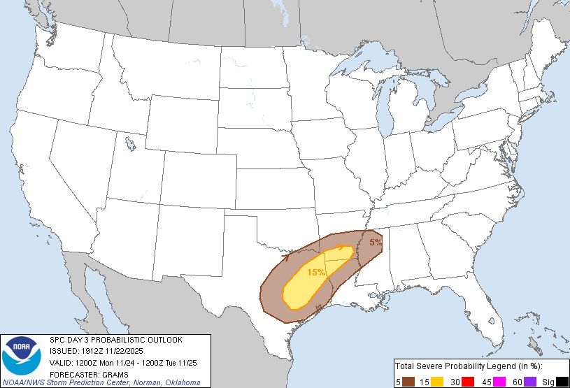
November 23, 2025 at 3:43 PM
D3
#SlightRisk in SW #DixieAlley esp #Shreveport #Austin #RoundRock #cedarpark #georgetowntx #Tyler #Waco #Killeen #Temple #Texarkana #CollegeStation #BryanTX #Conroe #HuntsvilleTX #Lufkin
15% #SevereWx risk
#Wxx #Wxtwitter #SPC #Tornado #Wind #Hail #BlueSkyWx #TXwx #ARwx #LAwx #CTXwx #BCSwx #HOUwx
#SlightRisk in SW #DixieAlley esp #Shreveport #Austin #RoundRock #cedarpark #georgetowntx #Tyler #Waco #Killeen #Temple #Texarkana #CollegeStation #BryanTX #Conroe #HuntsvilleTX #Lufkin
15% #SevereWx risk
#Wxx #Wxtwitter #SPC #Tornado #Wind #Hail #BlueSkyWx #TXwx #ARwx #LAwx #CTXwx #BCSwx #HOUwx

November 22, 2025 at 8:12 PM
Tuesday November 18, 2025 9:15PM CDT @noaa.gov @nws.noaa.gov National Weather Service station @pah.nws-bot.us ➡️ weather.gov/pah/ ⬅️ radars show #severe #thunderstorm in NW #Tennessee. #BlueSkyWX #WXBlueSky #WX #J3WX
November 19, 2025 at 2:03 AM
Tuesday November 18, 2025 9:15PM CDT @noaa.gov @nws.noaa.gov National Weather Service station @pah.nws-bot.us ➡️ weather.gov/pah/ ⬅️ radars show #severe #thunderstorm in NW #Tennessee. #BlueSkyWX #WXBlueSky #WX #J3WX
Monday November 17, 2025 7:30PM CDT @noaa.gov nws.noaa.gov station @lsx.nws-bot.us ➡️ weather.gov/lsx/ ⬅️ radars show #thunderstorms moving into the St Louis region. #BlueSkyWX #WXBlueSky #WX #STL #STLwx #J3WX #StLouisMO #StLouis #Missouri #MetroEast #MOwx
November 18, 2025 at 1:40 AM
Monday November 17, 2025 7:30PM CDT @noaa.gov nws.noaa.gov station @lsx.nws-bot.us ➡️ weather.gov/lsx/ ⬅️ radars show #thunderstorms moving into the St Louis region. #BlueSkyWX #WXBlueSky #WX #STL #STLwx #J3WX #StLouisMO #StLouis #Missouri #MetroEast #MOwx
NWS CPC: We are in #LaNina and will peak by NDJ before weakening to Neutral favoured by JFM
#ElNino possible by next summer-autumn (JJA-JAS)
However this La Nina then cool neutral will be feisty for #winter!
#BlueSkyWx #BlueSky #Wxx #WxTwitter
#ElNino possible by next summer-autumn (JJA-JAS)
However this La Nina then cool neutral will be feisty for #winter!
#BlueSkyWx #BlueSky #Wxx #WxTwitter


November 13, 2025 at 5:24 PM
NWS CPC: We are in #LaNina and will peak by NDJ before weakening to Neutral favoured by JFM
#ElNino possible by next summer-autumn (JJA-JAS)
However this La Nina then cool neutral will be feisty for #winter!
#BlueSkyWx #BlueSky #Wxx #WxTwitter
#ElNino possible by next summer-autumn (JJA-JAS)
However this La Nina then cool neutral will be feisty for #winter!
#BlueSkyWx #BlueSky #Wxx #WxTwitter
#FungWong now extratropical after landfalling in #Naha #Okinawa area
#Wxx #Wxtwitter #TropicsWx #BlueSkyWx #台風26号 #UwanPH #TyphoonFungWong #Tropicalstormfungwong #Japan #tropicalstorm #Typhoon
#Wxx #Wxtwitter #TropicsWx #BlueSkyWx #台風26号 #UwanPH #TyphoonFungWong #Tropicalstormfungwong #Japan #tropicalstorm #Typhoon

November 13, 2025 at 5:15 PM
#FungWong now extratropical after landfalling in #Naha #Okinawa area
#Wxx #Wxtwitter #TropicsWx #BlueSkyWx #台風26号 #UwanPH #TyphoonFungWong #Tropicalstormfungwong #Japan #tropicalstorm #Typhoon
#Wxx #Wxtwitter #TropicsWx #BlueSkyWx #台風26号 #UwanPH #TyphoonFungWong #Tropicalstormfungwong #Japan #tropicalstorm #Typhoon