


Hope you enjoy exploring this cool 3D app of the ocean focusing on NOAA World Ocean Atlas water column measurements of temp, salinity, dissolved O2, and nutrients!
#voxels #EcologicalMarineUnits
www.esri.com/about/newsro...
🌊 🦑 🌎 🌍 🌏 #GISchat #geogchat #geogsky
#voxels #EcologicalMarineUnits
www.esri.com/about/newsro...
🌊 🦑 🌎 🌍 🌏 #GISchat #geogchat #geogsky
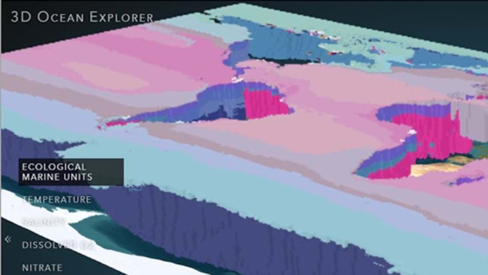
Explore a 3D App of the Ocean
In this 10-minute tutorial, learn how 3D scenes and interactive controls allow for greater data exploration with the 3D Ocean Explorer app.
www.esri.com
August 1, 2025 at 8:22 PM
Hope you enjoy exploring this cool 3D app of the ocean focusing on NOAA World Ocean Atlas water column measurements of temp, salinity, dissolved O2, and nutrients!
#voxels #EcologicalMarineUnits
www.esri.com/about/newsro...
🌊 🦑 🌎 🌍 🌏 #GISchat #geogchat #geogsky
#voxels #EcologicalMarineUnits
www.esri.com/about/newsro...
🌊 🦑 🌎 🌍 🌏 #GISchat #geogchat #geogsky
Creating NetCDF files for Analysis and Visualization in ArcGIS (including for #EcologicalMarineUnits or EMUs) https://www.esri.com/arcgis-blog/products/arcgis/data-management/creating-netcdf-files-for-analysis-and-visualization-in-arcgis/ via @kvangraafeiland
Creating NetCDF files for Analysis and Visualization in ArcGIS
www.esri.com
November 8, 2024 at 1:04 PM
Creating NetCDF files for Analysis and Visualization in ArcGIS (including for #EcologicalMarineUnits or EMUs) https://www.esri.com/arcgis-blog/products/arcgis/data-management/creating-netcdf-files-for-analysis-and-visualization-in-arcgis/ via @kvangraafeiland
Algal blooms from 2000-2015 & toxins released into water AND air! How to predict WHERE more harmful blooms will occur, esp w/sea level rise? Forest-based classification & regression tool w/#EcologicalMarineUnits dissO2 + nutrient data! #EsriOceanForum #AI #MachineLearning


November 8, 2024 at 10:42 PM
Algal blooms from 2000-2015 & toxins released into water AND air! How to predict WHERE more harmful blooms will occur, esp w/sea level rise? Forest-based classification & regression tool w/#EcologicalMarineUnits dissO2 + nutrient data! #EsriOceanForum #AI #MachineLearning
HOT: Get the #EcologicalMarineUnits localization task for @ArcGISPro PLUS sample ocean data from Hawaii, Santa Barbara, Gulf of Mexico datasets from <a href="http://esriurlcom.com/LocalEMU" class="hover:underline text-blue-600 dark:text-sky-400 no-card-link" target="_blank" rel="noopener" data-link="bsky">http://esriurlcom.com/LocalEMU #EsriOceanForum

November 8, 2024 at 10:42 PM
HOT: Get the #EcologicalMarineUnits localization task for @ArcGISPro PLUS sample ocean data from Hawaii, Santa Barbara, Gulf of Mexico datasets from <a href="http://esriurlcom.com/LocalEMU" class="hover:underline text-blue-600 dark:text-sky-400 no-card-link" target="_blank" rel="noopener" data-link="bsky">http://esriurlcom.com/LocalEMU #EsriOceanForum
An important step in localizing #EcologicalMarineUnits and new capability in @ArcGISPro is 3D interpolation of #ocean point measurements #EsriOceanForum


November 8, 2024 at 10:42 PM
An important step in localizing #EcologicalMarineUnits and new capability in @ArcGISPro is 3D interpolation of #ocean point measurements #EsriOceanForum
A suggested workflow for bringing the global #EcologicalMarineUnits down to local scales. This is also encapsulated in an @ArcGISPro Task #EsriOceanForum


November 8, 2024 at 10:42 PM
A suggested workflow for bringing the global #EcologicalMarineUnits down to local scales. This is also encapsulated in an @ArcGISPro Task #EsriOceanForum
Our new #openacess article for your reading pleasure "Stratifying ocean sampling globally & with depth to account for environmental variability" <a href="http://bit.ly/2Lqgxhi" class="hover:underline text-blue-600 dark:text-sky-400 no-card-link" target="_blank" rel="noopener" data-link="bsky">http://bit.ly/2Lqgxhi #ecologicalmarineunits #oceans #GIS

November 8, 2024 at 11:49 PM
Our new #openacess article for your reading pleasure "Stratifying ocean sampling globally & with depth to account for environmental variability" <a href="http://bit.ly/2Lqgxhi" class="hover:underline text-blue-600 dark:text-sky-400 no-card-link" target="_blank" rel="noopener" data-link="bsky">http://bit.ly/2Lqgxhi #ecologicalmarineunits #oceans #GIS
Higher-resolution EMUs! #oceans #ecologicalmarineunits #EMU <a href="http://arcg.is/2x2gIF6" class="hover:underline text-blue-600 dark:text-sky-400 no-card-link" target="_blank" rel="noopener" data-link="bsky">http://arcg.is/2x2gIF6

November 9, 2024 at 5:16 AM
Higher-resolution EMUs! #oceans #ecologicalmarineunits #EMU <a href="http://arcg.is/2x2gIF6" class="hover:underline text-blue-600 dark:text-sky-400 no-card-link" target="_blank" rel="noopener" data-link="bsky">http://arcg.is/2x2gIF6
1st result of @usioosgov animal telemetry use case of #EcologicalMarineUnits at #EsriUC (elephant seal home ranges)


November 9, 2024 at 6:10 AM
1st result of @usioosgov animal telemetry use case of #EcologicalMarineUnits at #EsriUC (elephant seal home ranges)
How Agency Data Turned into 3-D Maps of the #Oceans #Esri #EcologicalMarineUnits <a href="http://www.nextgov.com/big-data/2016/11/how-agency-data-turned-3-d-maps-oceans/132941/" class="hover:underline text-blue-600 dark:text-sky-400 no-card-link" target="_blank" rel="noopener" data-link="bsky">http://www.nextgov.com/big-data/2016/11/how-agency-data-turned-3-d-maps-oceans/132941/ via @nextgov
How Agency Data Turned into 3-D Maps of the Oceans
Anyone with a web browser can click on sections of the oc...
www.nextgov.com
November 9, 2024 at 9:45 AM
How Agency Data Turned into 3-D Maps of the #Oceans #Esri #EcologicalMarineUnits <a href="http://www.nextgov.com/big-data/2016/11/how-agency-data-turned-3-d-maps-oceans/132941/" class="hover:underline text-blue-600 dark:text-sky-400 no-card-link" target="_blank" rel="noopener" data-link="bsky">http://www.nextgov.com/big-data/2016/11/how-agency-data-turned-3-d-maps-oceans/132941/ via @nextgov