


Xavier Fischer
@xfischer.bsky.social
Principal .NET Software Engineer - @EDB @edbpostgres.bsky.social
GeoJSON dot Net co-owner
Running elevationapi.com - Opinions are my own
GeoJSON dot Net co-owner
Running elevationapi.com - Opinions are my own
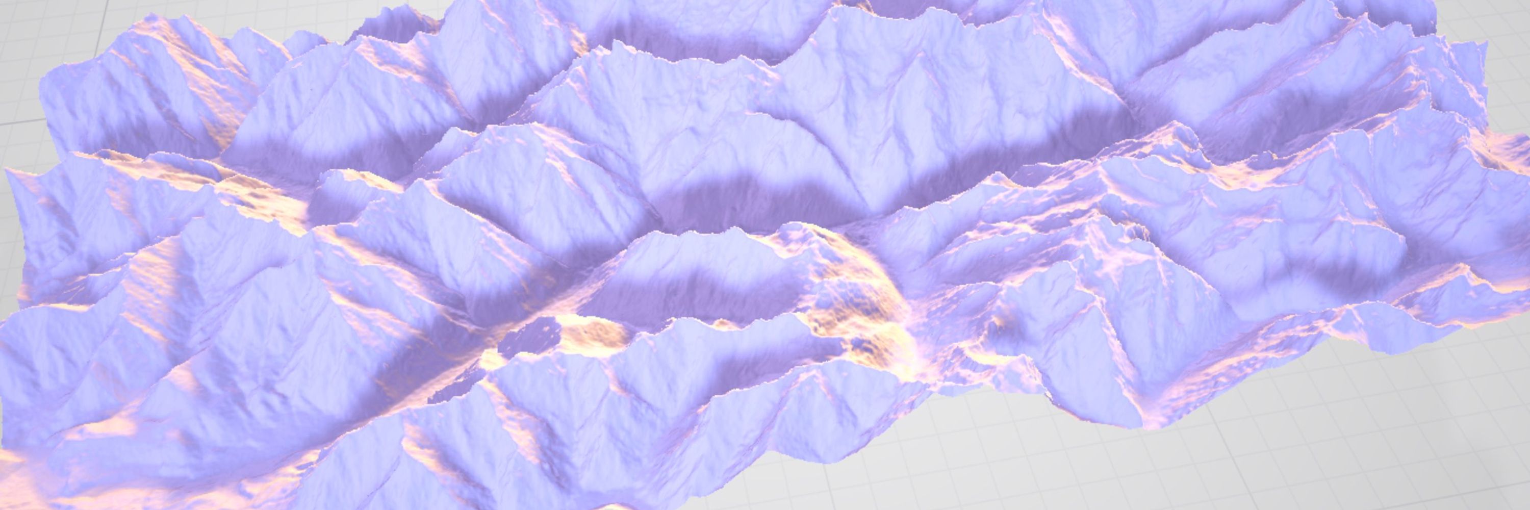
Very very good resolution in the Alps => TRUE
January 14, 2025 at 3:18 PM
Very very good resolution in the Alps => TRUE

🐝
Enfants déposés au bus ✅
Chats nourris ✅
Abeilles abreuvées ✅
Enfants déposés au bus ✅
Chats nourris ✅
Abeilles abreuvées ✅
November 21, 2024 at 9:31 PM
🐝
Enfants déposés au bus ✅
Chats nourris ✅
Abeilles abreuvées ✅
Enfants déposés au bus ✅
Chats nourris ✅
Abeilles abreuvées ✅
Poke @DisruptiveHoLin
Ça vient d’une recruteuse d’un cabinet parisien. Belle tentative osée !
Ça vient d’une recruteuse d’un cabinet parisien. Belle tentative osée !

November 21, 2024 at 9:15 PM
Poke @DisruptiveHoLin
Ça vient d’une recruteuse d’un cabinet parisien. Belle tentative osée !
Ça vient d’une recruteuse d’un cabinet parisien. Belle tentative osée !
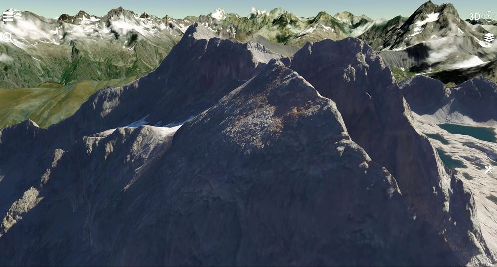
3D from Terrain RGB 1 meter vs Google Earth. That's the #saintevictoire I know :)
data and imagery : @IGNFrance
#GIS #3D
data and imagery : @IGNFrance
#GIS #3D


November 21, 2024 at 10:14 PM
3D from Terrain RGB 1 meter vs Google Earth. That's the #saintevictoire I know :)
data and imagery : @IGNFrance
#GIS #3D
data and imagery : @IGNFrance
#GIS #3D
1m DEM (vs 30m) in 3D
cc @pheeelicks ProceduralGL, @MapTiler_FR imagery and @IGNFrance data crunched to terrainRGB by @ElevationApi Live demo soon
cc @pheeelicks ProceduralGL, @MapTiler_FR imagery and @IGNFrance data crunched to terrainRGB by @ElevationApi Live demo soon


November 21, 2024 at 10:14 PM
1m DEM (vs 30m) in 3D
cc @pheeelicks ProceduralGL, @MapTiler_FR imagery and @IGNFrance data crunched to terrainRGB by @ElevationApi Live demo soon
cc @pheeelicks ProceduralGL, @MapTiler_FR imagery and @IGNFrance data crunched to terrainRGB by @ElevationApi Live demo soon


Hill shading with 5m DEM from @IGNFrance.
Comparison with MapTiler as reference.
(project with @UtagawaVTT in progress). Made with #Dotnet.
Comparison with MapTiler as reference.
(project with @UtagawaVTT in progress). Made with #Dotnet.


November 21, 2024 at 10:14 PM
Hill shading with 5m DEM from @IGNFrance.
Comparison with MapTiler as reference.
(project with @UtagawaVTT in progress). Made with #Dotnet.
Comparison with MapTiler as reference.
(project with @UtagawaVTT in progress). Made with #Dotnet.
Tile index server under 40 lines of code with #AspNetCore #minimalapi with @SixLabors ImageSharp, here in #QGIS.


November 21, 2024 at 10:14 PM
Tile index server under 40 lines of code with #AspNetCore #minimalapi with @SixLabors ImageSharp, here in #QGIS.
20s to generate this #Marseille model with #OpenStreetMap data using ElevationApi CLI tool powered by #dotnetcore :)

November 21, 2024 at 10:13 PM
20s to generate this #Marseille model with #OpenStreetMap data using ElevationApi CLI tool powered by #dotnetcore :)
J'étais surpris que nombre d'acteurs ayant vu la démo ont eu du mal à croire que ce n'était "que" de l'#OpenData (ici #OpenStreetMap, @stamen, ASTER GDEMv2 via @Sketchfab) mais aussi en France et en Suisse avec des MNT < 5m et de l'imagerie < 50cm

November 21, 2024 at 10:13 PM
J'étais surpris que nombre d'acteurs ayant vu la démo ont eu du mal à croire que ce n'était "que" de l'#OpenData (ici #OpenStreetMap, @stamen, ASTER GDEMv2 via @Sketchfab) mais aussi en France et en Suisse avec des MNT < 5m et de l'imagerie < 50cm
🇨🇭@swisstopo SwissAlti 50cm DEM is available on http://elevationapi.com. Data from @swiss_geoportal Incredible level of detail, with swissImage imagery. See below for @Sketchfab links !
#GIS #OpenData #dotnetcore #swisstopo
#GIS #OpenData #dotnetcore #swisstopo


November 21, 2024 at 10:12 PM
🇨🇭@swisstopo SwissAlti 50cm DEM is available on http://elevationapi.com. Data from @swiss_geoportal Incredible level of detail, with swissImage imagery. See below for @Sketchfab links !
#GIS #OpenData #dotnetcore #swisstopo
#GIS #OpenData #dotnetcore #swisstopo
We proudly welcome 🇨🇭 @swisstopo to http://elevationapi.com !
SwissALTI3D (2m) and SwissImage #gis #opendata gathered from @swiss_geoportal
👉 Embark in a virtual tour of Bernese Alps here on @Sketchfab : https://skfb.ly/opEHV Generated on http://elevationapi.com Thread 1/9
SwissALTI3D (2m) and SwissImage #gis #opendata gathered from @swiss_geoportal
👉 Embark in a virtual tour of Bernese Alps here on @Sketchfab : https://skfb.ly/opEHV Generated on http://elevationapi.com Thread 1/9

November 21, 2024 at 10:12 PM
We proudly welcome 🇨🇭 @swisstopo to http://elevationapi.com !
SwissALTI3D (2m) and SwissImage #gis #opendata gathered from @swiss_geoportal
👉 Embark in a virtual tour of Bernese Alps here on @Sketchfab : https://skfb.ly/opEHV Generated on http://elevationapi.com Thread 1/9
SwissALTI3D (2m) and SwissImage #gis #opendata gathered from @swiss_geoportal
👉 Embark in a virtual tour of Bernese Alps here on @Sketchfab : https://skfb.ly/opEHV Generated on http://elevationapi.com Thread 1/9
Physical > digital > physical-that-can-sit-on-your-table Here model of Monte Sant’Angelo STL 3D printed with @OpenTopography's Jaxa AW3D30 dataset. So happy to make people happy 😊

November 21, 2024 at 10:11 PM
Physical > digital > physical-that-can-sit-on-your-table Here model of Monte Sant’Angelo STL 3D printed with @OpenTopography's Jaxa AW3D30 dataset. So happy to make people happy 😊
With the right tools, you can get the best out of #opendata. Credits to @swiss_geoportal and @Sketchfab for the viewer
1) Google
2) Cesium
3) MapBox
4) ElevationAPI
1) Google
2) Cesium
3) MapBox
4) ElevationAPI


November 21, 2024 at 10:11 PM
With the right tools, you can get the best out of #opendata. Credits to @swiss_geoportal and @Sketchfab for the viewer
1) Google
2) Cesium
3) MapBox
4) ElevationAPI
1) Google
2) Cesium
3) MapBox
4) ElevationAPI
Run test for 4M triangles model of Jungfrau from @swiss_geoportal, swissAlti3D dataset. (Imagery : Esri)


November 21, 2024 at 10:11 PM
Run test for 4M triangles model of Jungfrau from @swiss_geoportal, swissAlti3D dataset. (Imagery : Esri)
Let's compare classic global datasets with @IGNFrance RGE Alti 5m and 1m...
Imagery: @Mapbox satellite. See them here on @Sketchfab : https://sketchfab.com/xfischer/collections/elevationapi-community
Imagery: @Mapbox satellite. See them here on @Sketchfab : https://sketchfab.com/xfischer/collections/elevationapi-community


November 21, 2024 at 10:11 PM
Let's compare classic global datasets with @IGNFrance RGE Alti 5m and 1m...
Imagery: @Mapbox satellite. See them here on @Sketchfab : https://sketchfab.com/xfischer/collections/elevationapi-community
Imagery: @Mapbox satellite. See them here on @Sketchfab : https://sketchfab.com/xfischer/collections/elevationapi-community
#GIS See how @IGNFrance RGE Alti 1m compares to 30m global datasets.
STL files generated with http://elevationapi.com
STL files generated with http://elevationapi.com


November 21, 2024 at 10:11 PM
#GIS See how @IGNFrance RGE Alti 1m compares to 30m global datasets.
STL files generated with http://elevationapi.com
STL files generated with http://elevationapi.com
Careful with that Axe, Eugene : use mesh reduction (credits to @rms80) to reduce model size.

November 21, 2024 at 10:11 PM
Careful with that Axe, Eugene : use mesh reduction (credits to @rms80) to reduce model size.
🎉Announcing @IGNFrance RGE Alti 5m availability for France and Corsica on http://elevationapi.com
Generate fine 3D models now using this great dataset !
Generate fine 3D models now using this great dataset !

November 21, 2024 at 10:10 PM
🎉Announcing @IGNFrance RGE Alti 5m availability for France and Corsica on http://elevationapi.com
Generate fine 3D models now using this great dataset !
Generate fine 3D models now using this great dataset !
Testing QEM mesh reduction... aaaaand that's pretty cool :)


November 21, 2024 at 10:10 PM
Testing QEM mesh reduction... aaaaand that's pretty cool :)
Project in progress. 👇🇪🇸
Sierra de Irta con @ADD4Dimensions , 5m DEM / imagery from @IGN_es, datos @openstreetmap. 734 MB model processed by Elevation API CLI in 1min... coming soon. 😎
Sierra de Irta con @ADD4Dimensions , 5m DEM / imagery from @IGN_es, datos @openstreetmap. 734 MB model processed by Elevation API CLI in 1min... coming soon. 😎

November 21, 2024 at 10:10 PM
Project in progress. 👇🇪🇸
Sierra de Irta con @ADD4Dimensions , 5m DEM / imagery from @IGN_es, datos @openstreetmap. 734 MB model processed by Elevation API CLI in 1min... coming soon. 😎
Sierra de Irta con @ADD4Dimensions , 5m DEM / imagery from @IGN_es, datos @openstreetmap. 734 MB model processed by Elevation API CLI in 1min... coming soon. 😎
DEM comparison between #OpenData 1) Jaxa AW3D30 from @OpenTopography 2) IGN RGE Alti 5m from @IGNFrance 3) IGN RGE Alti 1m from @IGNFrance Generated by the API using #dotnet on #Microsoft stack.
Imagery: @Mapbox
Imagery: @Mapbox


November 21, 2024 at 10:09 PM
DEM comparison between #OpenData 1) Jaxa AW3D30 from @OpenTopography 2) IGN RGE Alti 5m from @IGNFrance 3) IGN RGE Alti 1m from @IGNFrance Generated by the API using #dotnet on #Microsoft stack.
Imagery: @Mapbox
Imagery: @Mapbox

Sunday with the kids

November 21, 2024 at 9:12 PM
Sunday with the kids