


Chris-WeatherSources
@weathersources.bsky.social
Delivering reliable weather sources with a focus on Cyclones(Hurricanes). Hobby weather fan, not a pro. 100% weather data & information to help those seeking it.
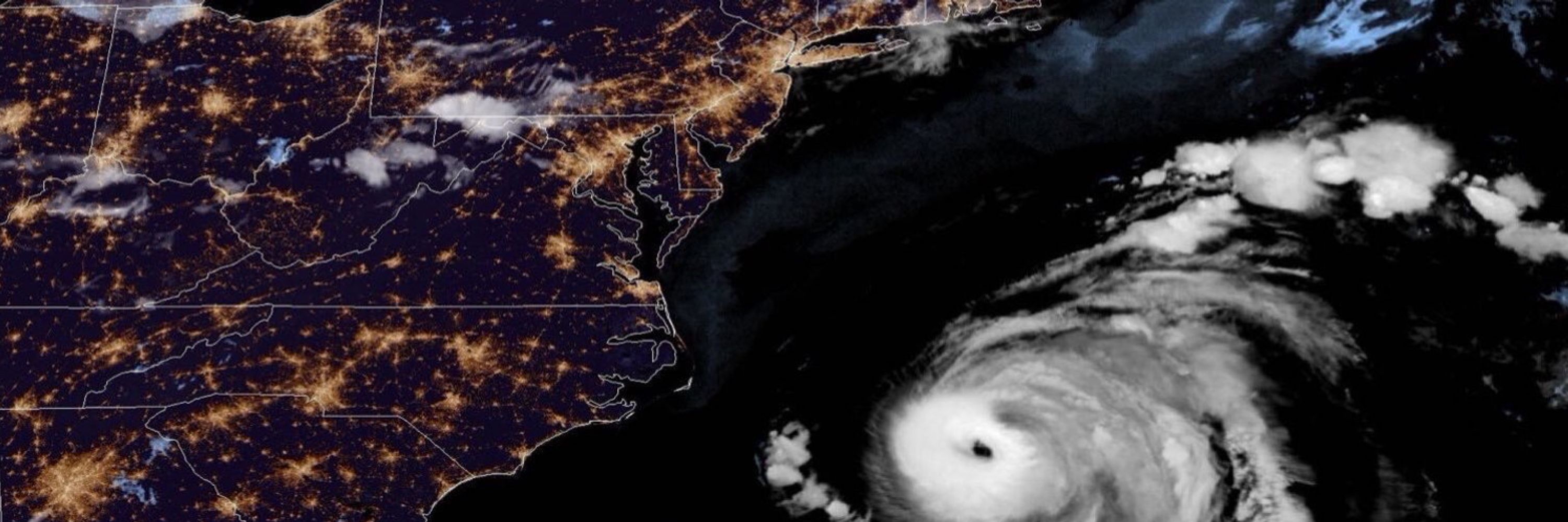
Eye of Hurricane Melissa returning on satellite as heads towards Cuba Tuesday evening. 28oct2025
October 29, 2025 at 2:59 AM
Eye of Hurricane Melissa returning on satellite as heads towards Cuba Tuesday evening. 28oct2025
Mountains of Jamaica and land interaction clearly disrupting Hurricane Melissa by late Tuesday 28oct2025
October 28, 2025 at 10:39 PM
Mountains of Jamaica and land interaction clearly disrupting Hurricane Melissa by late Tuesday 28oct2025
Hurricane Melissa beginning landfall into Southwest Jamaica. Core winds likely moving onshore with eye / eye wall area. 930aEST/1030aEDT 28oct2025
October 28, 2025 at 2:40 PM
Hurricane Melissa beginning landfall into Southwest Jamaica. Core winds likely moving onshore with eye / eye wall area. 930aEST/1030aEDT 28oct2025
Melissa nearing Jamaica
7aEST 28oct
Center about:
34miles(55km) SW Treasure Beach.
36miles(58km) SW Parottee Bay.
40miles(64km) SSW Black River.
Eye 11.5miles(18.5km) diameter.
Strongest winds around that eye.
Hurricane winds extend up to 30miles(45km) from center.
hurricanes.gov
7aEST 28oct
Center about:
34miles(55km) SW Treasure Beach.
36miles(58km) SW Parottee Bay.
40miles(64km) SSW Black River.
Eye 11.5miles(18.5km) diameter.
Strongest winds around that eye.
Hurricane winds extend up to 30miles(45km) from center.
hurricanes.gov
October 28, 2025 at 12:14 PM
Melissa nearing Jamaica
7aEST 28oct
Center about:
34miles(55km) SW Treasure Beach.
36miles(58km) SW Parottee Bay.
40miles(64km) SSW Black River.
Eye 11.5miles(18.5km) diameter.
Strongest winds around that eye.
Hurricane winds extend up to 30miles(45km) from center.
hurricanes.gov
7aEST 28oct
Center about:
34miles(55km) SW Treasure Beach.
36miles(58km) SW Parottee Bay.
40miles(64km) SSW Black River.
Eye 11.5miles(18.5km) diameter.
Strongest winds around that eye.
Hurricane winds extend up to 30miles(45km) from center.
hurricanes.gov
175mph(280km/h) Cat5 Hurricane Melissa starting its anticipated turn towards Jamaica 27-Oct2025 1pEST,2pEDT/AST
October 27, 2025 at 6:00 PM
175mph(280km/h) Cat5 Hurricane Melissa starting its anticipated turn towards Jamaica 27-Oct2025 1pEST,2pEDT/AST
Hurricane Melissa Sunday evening. 26-Oct2025
October 27, 2025 at 1:34 AM
Hurricane Melissa Sunday evening. 26-Oct2025
Invest 98L moving West across Caribbean Sea. Several possibilities on future. High impact rain event certainly possible. Wide range on winds. 20–Oct2025
October 21, 2025 at 1:22 AM
Invest 98L moving West across Caribbean Sea. Several possibilities on future. High impact rain event certainly possible. Wide range on winds. 20–Oct2025
96L in far North Atlantic Northwest of The Azores building small ring of storms around its core. NHC gives it 60% chance of obtaining brief Sub-tropical or tropical status. Already has the winds. Just needs the inner core pieces. 9-Oct2025
October 10, 2025 at 1:11 AM
96L in far North Atlantic Northwest of The Azores building small ring of storms around its core. NHC gives it 60% chance of obtaining brief Sub-tropical or tropical status. Already has the winds. Just needs the inner core pieces. 9-Oct2025
Jerry outrunning its own storms Wednesday morning.
8-Oct2025
8-Oct2025
October 8, 2025 at 11:31 AM
Jerry outrunning its own storms Wednesday morning.
8-Oct2025
8-Oct2025
And just 24 hours later Euro model backed off those higher totals. That’s why I typically don’t post 7 days+ out. But there was some concerning more consistent trends earlier so mentioned. Let’s hope we keep trending less. But please be aware towards next weekend.
3-Oct2025
3-Oct2025
October 4, 2025 at 1:57 AM
And just 24 hours later Euro model backed off those higher totals. That’s why I typically don’t post 7 days+ out. But there was some concerning more consistent trends earlier so mentioned. Let’s hope we keep trending less. But please be aware towards next weekend.
3-Oct2025
3-Oct2025
And just 24 hours later Euro model backed off those higher totals. That’s why I typically don’t post 7 days+ out. But there was some concerning more consistent trends earlier so mentioned. Let’s hope we keep trending less. But please be aware towards next weekend.
3-Oct2025
3-Oct2025
October 4, 2025 at 1:57 AM
And just 24 hours later Euro model backed off those higher totals. That’s why I typically don’t post 7 days+ out. But there was some concerning more consistent trends earlier so mentioned. Let’s hope we keep trending less. But please be aware towards next weekend.
3-Oct2025
3-Oct2025
There are early hints developing tropical cyclone South of Mexico in Eastern Pacific may push a swath of moisture up across portions of the Southwest US towards the end of next week/weekend. Please be monitoring. (Amounts/locations likely change this far out in time) 2Oct2025 #AZwx #CAwx #UTwx #NMwx
October 3, 2025 at 12:25 AM
There are early hints developing tropical cyclone South of Mexico in Eastern Pacific may push a swath of moisture up across portions of the Southwest US towards the end of next week/weekend. Please be monitoring. (Amounts/locations likely change this far out in time) 2Oct2025 #AZwx #CAwx #UTwx #NMwx
Humberto finally works up the courage to ask Imelda out for a dance. The dance floor opens this Tuesday.
#DancingWithTheStars …err Storms
#DWTS
#DancingWithTheStars …err Storms
#DWTS
September 29, 2025 at 2:37 PM
Humberto finally works up the courage to ask Imelda out for a dance. The dance floor opens this Tuesday.
#DancingWithTheStars …err Storms
#DWTS
#DancingWithTheStars …err Storms
#DWTS
Post tropical cyclone Gabrielle moving through The Azores Thursday evening. 25Sept2025
September 26, 2025 at 2:34 AM
Post tropical cyclone Gabrielle moving through The Azores Thursday evening. 25Sept2025