


Chris-WeatherSources
@weathersources.bsky.social
Delivering reliable weather sources with a focus on Cyclones(Hurricanes). Hobby weather fan, not a pro. 100% weather data & information to help those seeking it.
Tue 28Oct 11pEDT/AST,10pEST winds 130mph(215km/h)
Hurricane winds extend up to 30miles(45km) from center, TS winds up to 195miles(315km).
Storm about 65miles(105km) N of Jamaica.
About 45miles(72km) S of Cuba.
About 68miles(110km) SW of Santiago, Cuba.
About 98miles(158km) WSW of Guantánamo Bay,Cuba
Hurricane winds extend up to 30miles(45km) from center, TS winds up to 195miles(315km).
Storm about 65miles(105km) N of Jamaica.
About 45miles(72km) S of Cuba.
About 68miles(110km) SW of Santiago, Cuba.
About 98miles(158km) WSW of Guantánamo Bay,Cuba

October 29, 2025 at 3:30 AM
Tue 28Oct 11pEDT/AST,10pEST winds 130mph(215km/h)
Hurricane winds extend up to 30miles(45km) from center, TS winds up to 195miles(315km).
Storm about 65miles(105km) N of Jamaica.
About 45miles(72km) S of Cuba.
About 68miles(110km) SW of Santiago, Cuba.
About 98miles(158km) WSW of Guantánamo Bay,Cuba
Hurricane winds extend up to 30miles(45km) from center, TS winds up to 195miles(315km).
Storm about 65miles(105km) N of Jamaica.
About 45miles(72km) S of Cuba.
About 68miles(110km) SW of Santiago, Cuba.
About 98miles(158km) WSW of Guantánamo Bay,Cuba
Eye of Hurricane Melissa returning on satellite as heads towards Cuba Tuesday evening. 28oct2025
October 29, 2025 at 2:59 AM
Eye of Hurricane Melissa returning on satellite as heads towards Cuba Tuesday evening. 28oct2025
Mountains of Jamaica and land interaction clearly disrupting Hurricane Melissa by late Tuesday 28oct2025
October 28, 2025 at 10:39 PM
Mountains of Jamaica and land interaction clearly disrupting Hurricane Melissa by late Tuesday 28oct2025
Hurricane Melissa beginning landfall into Southwest Jamaica. Core winds likely moving onshore with eye / eye wall area. 930aEST/1030aEDT 28oct2025
October 28, 2025 at 2:40 PM
Hurricane Melissa beginning landfall into Southwest Jamaica. Core winds likely moving onshore with eye / eye wall area. 930aEST/1030aEDT 28oct2025
Melissa nearing Jamaica
7aEST 28oct
Center about:
34miles(55km) SW Treasure Beach.
36miles(58km) SW Parottee Bay.
40miles(64km) SSW Black River.
Eye 11.5miles(18.5km) diameter.
Strongest winds around that eye.
Hurricane winds extend up to 30miles(45km) from center.
hurricanes.gov
7aEST 28oct
Center about:
34miles(55km) SW Treasure Beach.
36miles(58km) SW Parottee Bay.
40miles(64km) SSW Black River.
Eye 11.5miles(18.5km) diameter.
Strongest winds around that eye.
Hurricane winds extend up to 30miles(45km) from center.
hurricanes.gov
October 28, 2025 at 12:14 PM
Melissa nearing Jamaica
7aEST 28oct
Center about:
34miles(55km) SW Treasure Beach.
36miles(58km) SW Parottee Bay.
40miles(64km) SSW Black River.
Eye 11.5miles(18.5km) diameter.
Strongest winds around that eye.
Hurricane winds extend up to 30miles(45km) from center.
hurricanes.gov
7aEST 28oct
Center about:
34miles(55km) SW Treasure Beach.
36miles(58km) SW Parottee Bay.
40miles(64km) SSW Black River.
Eye 11.5miles(18.5km) diameter.
Strongest winds around that eye.
Hurricane winds extend up to 30miles(45km) from center.
hurricanes.gov
If there’s any ‘good’ news with a Cat5 landfall its those intense winds are confined to a smaller area.
As of 8pEDT/7pEST Monday 27-Oct2025 Hurricane force winds (74 to 175mph (120 to 280km/h)) extend out 30miles(45km) from center. (These numbers do fluctuate over time).
Hurricane Melissa. Jamaica.
As of 8pEDT/7pEST Monday 27-Oct2025 Hurricane force winds (74 to 175mph (120 to 280km/h)) extend out 30miles(45km) from center. (These numbers do fluctuate over time).
Hurricane Melissa. Jamaica.


October 28, 2025 at 12:02 AM
If there’s any ‘good’ news with a Cat5 landfall its those intense winds are confined to a smaller area.
As of 8pEDT/7pEST Monday 27-Oct2025 Hurricane force winds (74 to 175mph (120 to 280km/h)) extend out 30miles(45km) from center. (These numbers do fluctuate over time).
Hurricane Melissa. Jamaica.
As of 8pEDT/7pEST Monday 27-Oct2025 Hurricane force winds (74 to 175mph (120 to 280km/h)) extend out 30miles(45km) from center. (These numbers do fluctuate over time).
Hurricane Melissa. Jamaica.
175mph(280km/h) Cat5 Hurricane Melissa starting its anticipated turn towards Jamaica 27-Oct2025 1pEST,2pEDT/AST
October 27, 2025 at 6:00 PM
175mph(280km/h) Cat5 Hurricane Melissa starting its anticipated turn towards Jamaica 27-Oct2025 1pEST,2pEDT/AST
Hurricane Melissa Sunday evening. 26-Oct2025
October 27, 2025 at 1:34 AM
Hurricane Melissa Sunday evening. 26-Oct2025
Invest 98L moving West across Caribbean Sea. Several possibilities on future. High impact rain event certainly possible. Wide range on winds. 20–Oct2025
October 21, 2025 at 1:22 AM
Invest 98L moving West across Caribbean Sea. Several possibilities on future. High impact rain event certainly possible. Wide range on winds. 20–Oct2025
Tropical Storm Jerry with scattered rains into the Lesser Antilles Thursday evening. Large storm cluster sitting just East of Guadeloupe as of 9pEDT/AST on satellite shown here. 9-Oct2025

October 10, 2025 at 1:26 AM
Tropical Storm Jerry with scattered rains into the Lesser Antilles Thursday evening. Large storm cluster sitting just East of Guadeloupe as of 9pEDT/AST on satellite shown here. 9-Oct2025
96L in far North Atlantic Northwest of The Azores building small ring of storms around its core. NHC gives it 60% chance of obtaining brief Sub-tropical or tropical status. Already has the winds. Just needs the inner core pieces. 9-Oct2025
October 10, 2025 at 1:11 AM
96L in far North Atlantic Northwest of The Azores building small ring of storms around its core. NHC gives it 60% chance of obtaining brief Sub-tropical or tropical status. Already has the winds. Just needs the inner core pieces. 9-Oct2025
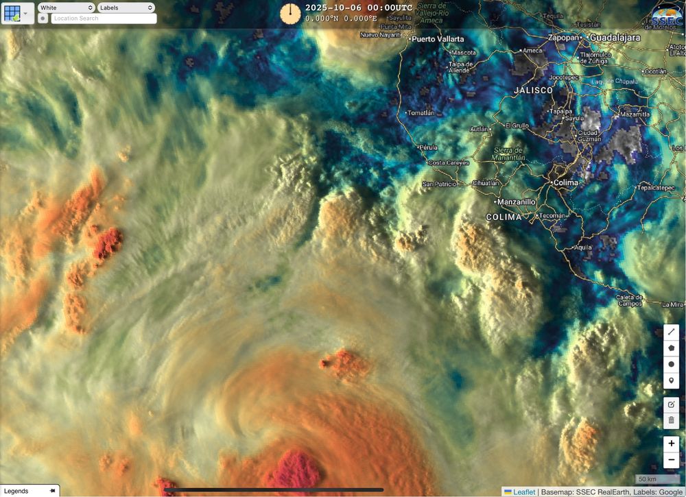
Flood threat now into early next week as 3 tropical systems in Eastern Pacific help funnel moisture up across portions of Western Mexico and Southwest US. 9-Oct2025


October 10, 2025 at 12:47 AM
Flood threat now into early next week as 3 tropical systems in Eastern Pacific help funnel moisture up across portions of Western Mexico and Southwest US. 9-Oct2025
Jerry outrunning its own storms Wednesday morning.
8-Oct2025
8-Oct2025
October 8, 2025 at 11:31 AM
Jerry outrunning its own storms Wednesday morning.
8-Oct2025
8-Oct2025
95L in Atlantic a broad mess of scattered showers currently. May develop this week, nearing Leeward Islands later in the week. 5-Oct2025


October 6, 2025 at 12:49 AM
95L in Atlantic a broad mess of scattered showers currently. May develop this week, nearing Leeward Islands later in the week. 5-Oct2025
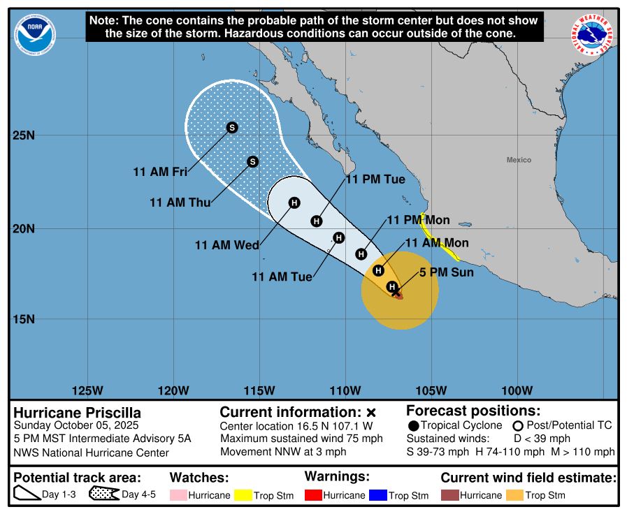
Hurricane Priscilla off SW Mexico. Tropical Storm Watch, including Puerto Vallarta & Manzanillo, NHC gives it about 10%+ chance of seeing Tropical Storm winds as storm passes well offshore. Scattered rains into region. Moisture may spread into SW US later in the week. 5-Oct2025

October 6, 2025 at 12:35 AM
Hurricane Priscilla off SW Mexico. Tropical Storm Watch, including Puerto Vallarta & Manzanillo, NHC gives it about 10%+ chance of seeing Tropical Storm winds as storm passes well offshore. Scattered rains into region. Moisture may spread into SW US later in the week. 5-Oct2025
And just 24 hours later Euro model backed off those higher totals. That’s why I typically don’t post 7 days+ out. But there was some concerning more consistent trends earlier so mentioned. Let’s hope we keep trending less. But please be aware towards next weekend.
3-Oct2025
3-Oct2025
October 4, 2025 at 1:57 AM
And just 24 hours later Euro model backed off those higher totals. That’s why I typically don’t post 7 days+ out. But there was some concerning more consistent trends earlier so mentioned. Let’s hope we keep trending less. But please be aware towards next weekend.
3-Oct2025
3-Oct2025
And just 24 hours later Euro model backed off those higher totals. That’s why I typically don’t post 7 days+ out. But there was some concerning more consistent trends earlier so mentioned. Let’s hope we keep trending less. But please be aware towards next weekend.
3-Oct2025
3-Oct2025
October 4, 2025 at 1:57 AM
And just 24 hours later Euro model backed off those higher totals. That’s why I typically don’t post 7 days+ out. But there was some concerning more consistent trends earlier so mentioned. Let’s hope we keep trending less. But please be aware towards next weekend.
3-Oct2025
3-Oct2025
Two areas in Atlantic 2-Oct2025:
-FL peninsula region low chance - wind shear very high. Rain maker.
-Area off Africa may develop and near Northeast Caribbean region around Thursday next week. Early models favor turn up and out like recent storms but not locked in yet
(Imelda & Humberto are no more)
-FL peninsula region low chance - wind shear very high. Rain maker.
-Area off Africa may develop and near Northeast Caribbean region around Thursday next week. Early models favor turn up and out like recent storms but not locked in yet
(Imelda & Humberto are no more)

October 3, 2025 at 12:46 AM
Two areas in Atlantic 2-Oct2025:
-FL peninsula region low chance - wind shear very high. Rain maker.
-Area off Africa may develop and near Northeast Caribbean region around Thursday next week. Early models favor turn up and out like recent storms but not locked in yet
(Imelda & Humberto are no more)
-FL peninsula region low chance - wind shear very high. Rain maker.
-Area off Africa may develop and near Northeast Caribbean region around Thursday next week. Early models favor turn up and out like recent storms but not locked in yet
(Imelda & Humberto are no more)
There are early hints developing tropical cyclone South of Mexico in Eastern Pacific may push a swath of moisture up across portions of the Southwest US towards the end of next week/weekend. Please be monitoring. (Amounts/locations likely change this far out in time) 2Oct2025 #AZwx #CAwx #UTwx #NMwx
October 3, 2025 at 12:25 AM
There are early hints developing tropical cyclone South of Mexico in Eastern Pacific may push a swath of moisture up across portions of the Southwest US towards the end of next week/weekend. Please be monitoring. (Amounts/locations likely change this far out in time) 2Oct2025 #AZwx #CAwx #UTwx #NMwx
Imelda expected to make its turn Tuesday.
Sept2025
Sept2025
September 30, 2025 at 1:15 AM
Imelda expected to make its turn Tuesday.
Sept2025
Sept2025
Humberto finally works up the courage to ask Imelda out for a dance. The dance floor opens this Tuesday.
#DancingWithTheStars …err Storms
#DWTS
#DancingWithTheStars …err Storms
#DWTS
September 29, 2025 at 2:37 PM
Humberto finally works up the courage to ask Imelda out for a dance. The dance floor opens this Tuesday.
#DancingWithTheStars …err Storms
#DWTS
#DancingWithTheStars …err Storms
#DWTS
(2/2 cont)
1 to 2ft higher tides may result in some minor coastal flooding US Southeast coast, especially at high tides (below 3ft+ criteria for surge watch/warning). Coastal rains FL to NC with moisture also pulled up into Eastern SC & NC even as storm turns this week. 28Sept2025
1 to 2ft higher tides may result in some minor coastal flooding US Southeast coast, especially at high tides (below 3ft+ criteria for surge watch/warning). Coastal rains FL to NC with moisture also pulled up into Eastern SC & NC even as storm turns this week. 28Sept2025


September 28, 2025 at 10:12 PM
(2/2 cont)
1 to 2ft higher tides may result in some minor coastal flooding US Southeast coast, especially at high tides (below 3ft+ criteria for surge watch/warning). Coastal rains FL to NC with moisture also pulled up into Eastern SC & NC even as storm turns this week. 28Sept2025
1 to 2ft higher tides may result in some minor coastal flooding US Southeast coast, especially at high tides (below 3ft+ criteria for surge watch/warning). Coastal rains FL to NC with moisture also pulled up into Eastern SC & NC even as storm turns this week. 28Sept2025
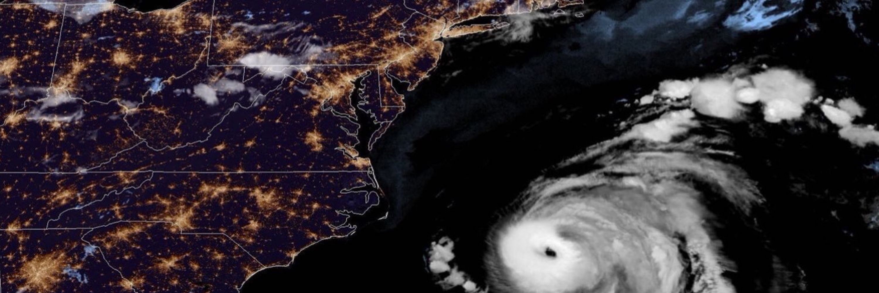
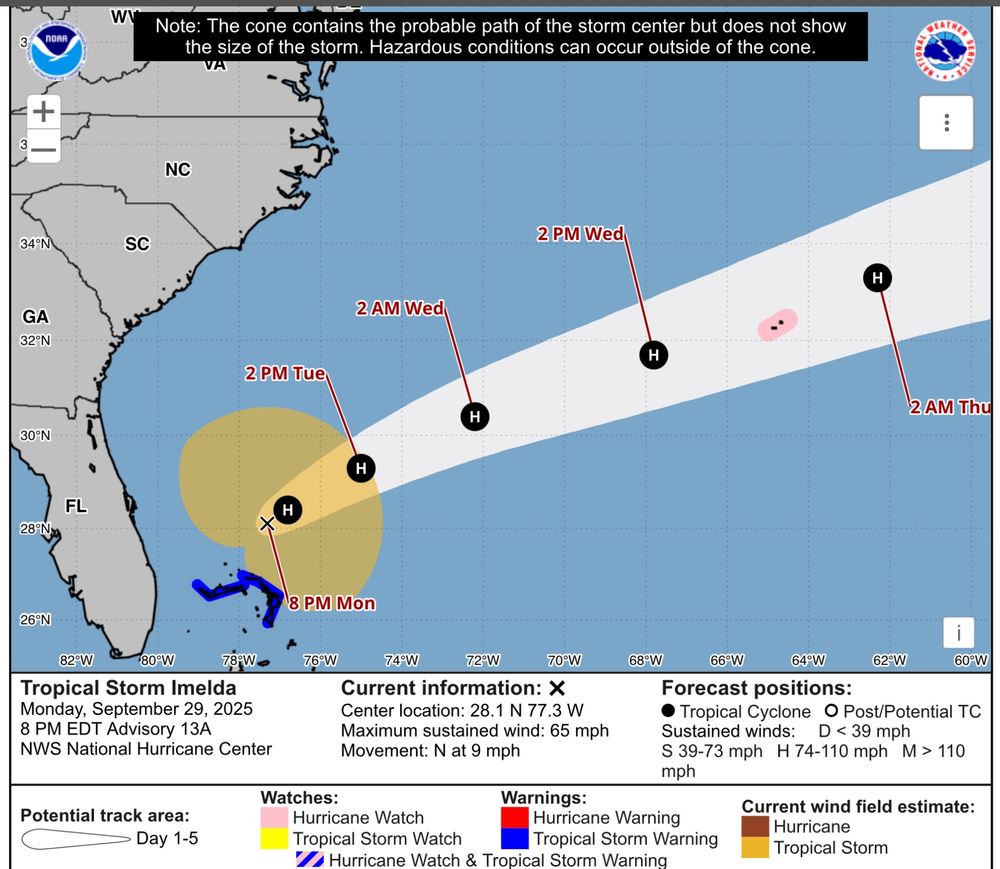
Tropical Storm Imelda moving North through Bahamas Sunday afternoon. No watch or warning for US as Tropical Storm winds expected to just stay offshore in current forecast.
(1/2 cont) 28Sept2025
(1/2 cont) 28Sept2025


September 28, 2025 at 10:10 PM
Tropical Storm Imelda moving North through Bahamas Sunday afternoon. No watch or warning for US as Tropical Storm winds expected to just stay offshore in current forecast.
(1/2 cont) 28Sept2025
(1/2 cont) 28Sept2025
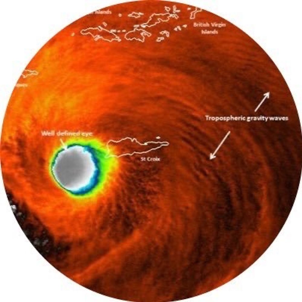
Beauty and the Beast - which one is which depends on your view of weather…
27Sept2025 TD9(former PTC9/94L) / Humberto
27Sept2025 TD9(former PTC9/94L) / Humberto

September 28, 2025 at 1:24 AM
Beauty and the Beast - which one is which depends on your view of weather…
27Sept2025 TD9(former PTC9/94L) / Humberto
27Sept2025 TD9(former PTC9/94L) / Humberto
Post tropical cyclone Gabrielle moving through The Azores Thursday evening. 25Sept2025
September 26, 2025 at 2:34 AM
Post tropical cyclone Gabrielle moving through The Azores Thursday evening. 25Sept2025