


Ian
@urbancarbonsnkr.bsky.social
Reposted by Ian

Today is #GISDay!
How do we use geographic information systems at UC ANR? Check out this story map about native pollinators created by our Informatics and GIS Statewide Program ➡️ bit.ly/4fRqazX
To learn more, visit bit.ly/4fRqjDv
How do we use geographic information systems at UC ANR? Check out this story map about native pollinators created by our Informatics and GIS Statewide Program ➡️ bit.ly/4fRqazX
To learn more, visit bit.ly/4fRqjDv

Native Pollinators
Delve into the world of native pollinators in the Bay Area
bit.ly
November 21, 2024 at 1:47 AM
Today is #GISDay!
How do we use geographic information systems at UC ANR? Check out this story map about native pollinators created by our Informatics and GIS Statewide Program ➡️ bit.ly/4fRqazX
To learn more, visit bit.ly/4fRqjDv
How do we use geographic information systems at UC ANR? Check out this story map about native pollinators created by our Informatics and GIS Statewide Program ➡️ bit.ly/4fRqazX
To learn more, visit bit.ly/4fRqjDv
Reposted by Ian

Did you know that you can learn GIS on WILDLABS?
@faunaflora.bsky.social has four introductory courses on GIS in our course catalogue:
❓What is GIS?
📝Introduction to QGIS
📡Introduction to ArcGIS Pro
🌍Becoming Confident in Spatial Analysis & Geoprocessing
wildlabs.net/courses
@faunaflora.bsky.social has four introductory courses on GIS in our course catalogue:
❓What is GIS?
📝Introduction to QGIS
📡Introduction to ArcGIS Pro
🌍Becoming Confident in Spatial Analysis & Geoprocessing
wildlabs.net/courses

March 18, 2025 at 2:37 PM
Did you know that you can learn GIS on WILDLABS?
@faunaflora.bsky.social has four introductory courses on GIS in our course catalogue:
❓What is GIS?
📝Introduction to QGIS
📡Introduction to ArcGIS Pro
🌍Becoming Confident in Spatial Analysis & Geoprocessing
wildlabs.net/courses
@faunaflora.bsky.social has four introductory courses on GIS in our course catalogue:
❓What is GIS?
📝Introduction to QGIS
📡Introduction to ArcGIS Pro
🌍Becoming Confident in Spatial Analysis & Geoprocessing
wildlabs.net/courses
Reposted by Ian

🚀 GeoAI Tutorial 17: Create a Labeled Dataset for Deep Learning 🌍
Learn how to create a labeled dataset interactively in a Jupyter environment—no desktop GIS required.
🎥 Watch the full tutorial here: youtu.be/QqjhLFN8Hdc
📓 Explore the notebook: geoai.gishub.org/examples/cre...
Learn how to create a labeled dataset interactively in a Jupyter environment—no desktop GIS required.
🎥 Watch the full tutorial here: youtu.be/QqjhLFN8Hdc
📓 Explore the notebook: geoai.gishub.org/examples/cre...
April 5, 2025 at 1:39 PM
🚀 GeoAI Tutorial 17: Create a Labeled Dataset for Deep Learning 🌍
Learn how to create a labeled dataset interactively in a Jupyter environment—no desktop GIS required.
🎥 Watch the full tutorial here: youtu.be/QqjhLFN8Hdc
📓 Explore the notebook: geoai.gishub.org/examples/cre...
Learn how to create a labeled dataset interactively in a Jupyter environment—no desktop GIS required.
🎥 Watch the full tutorial here: youtu.be/QqjhLFN8Hdc
📓 Explore the notebook: geoai.gishub.org/examples/cre...
Reposted by Ian

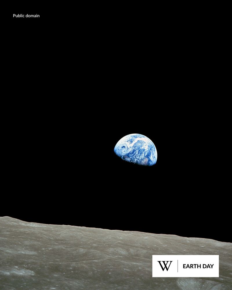
Earth Day is a reminder that we only have one planet. Sometimes, it takes seeing Earth from space to truly grasp how precious it is. 🧵⬇️ (1/4)
April 22, 2025 at 4:04 PM
Earth Day is a reminder that we only have one planet. Sometimes, it takes seeing Earth from space to truly grasp how precious it is. 🧵⬇️ (1/4)