
Tyler Morgan-Wall
@tylermw.com
R, data science, dataviz, maps, experimental design, raytracing. Developer of rayshader, rayrender, and the rayverse | PhD in Physics from Johns Hopkins | Penn
Thanks Adam! I'm looking forward to writing a vignette that's basically just a photography tutorial 😀
November 10, 2025 at 9:14 PM
Thanks Adam! I'm looking forward to writing a vignette that's basically just a photography tutorial 😀
Manhattanhenge: On May 28th/July 13th, the sun aligns with Manhattan's street grid 29° from N. This twice-a-year alignment of urban planning and orbital motion serves both as a temporal tourist attraction as well as a particular good test case for geospatial skymap alignment! #RStats #rayrender


November 9, 2025 at 10:49 PM
Manhattanhenge: On May 28th/July 13th, the sun aligns with Manhattan's street grid 29° from N. This twice-a-year alignment of urban planning and orbital motion serves both as a temporal tourist attraction as well as a particular good test case for geospatial skymap alignment! #RStats #rayrender
Rendering the peak of Mount Everest from sunrise to sunset in R with rayshader and rayrender
#RStats #rayrender #rayshader #rayverse
#RStats #rayrender #rayshader #rayverse
November 9, 2025 at 4:41 AM
Rendering the peak of Mount Everest from sunrise to sunset in R with rayshader and rayrender
#RStats #rayrender #rayshader #rayverse
#RStats #rayrender #rayshader #rayverse
Reposted by Tyler Morgan-Wall

I think that @davisvaughan.bsky.social figured this out.
add the following to your settings.json should do the trick
"window.title": "${activeEditorShort}${separator}${rootName}${separator}${profileName}${separator}${activeRepositoryBranchName}"
add the following to your settings.json should do the trick
"window.title": "${activeEditorShort}${separator}${rootName}${separator}${profileName}${separator}${activeRepositoryBranchName}"
November 7, 2025 at 4:30 AM
I think that @davisvaughan.bsky.social figured this out.
add the following to your settings.json should do the trick
"window.title": "${activeEditorShort}${separator}${rootName}${separator}${profileName}${separator}${activeRepositoryBranchName}"
add the following to your settings.json should do the trick
"window.title": "${activeEditorShort}${separator}${rootName}${separator}${profileName}${separator}${activeRepositoryBranchName}"
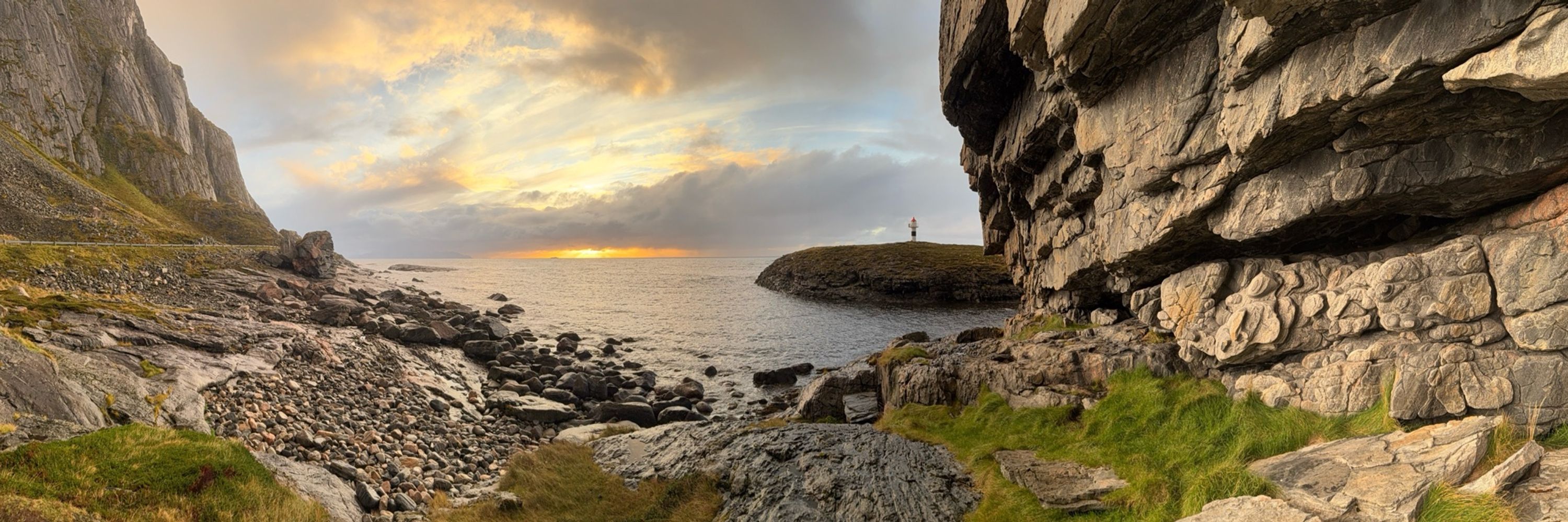
Nice! It’s interesting to try and intuit the geography from just the tree distribution.
November 8, 2025 at 3:13 PM
Nice! It’s interesting to try and intuit the geography from just the tree distribution.
Also: post-process exposure control like this is why you use a high dynamic range format like EXR when rendering, which rayrender now supports, due to the six months I spent getting all the required packages in the CRAN ecosystem for OpenEXR support!
November 8, 2025 at 4:20 AM
Also: post-process exposure control like this is why you use a high dynamic range format like EXR when rendering, which rayrender now supports, due to the six months I spent getting all the required packages in the CRAN ecosystem for OpenEXR support!
1) Keeping the exposure the same as the dawn image at noon: yuck!
2) Adjusting the exposure down three stops with rayimage::render_exposure(): Nice!
#RStats #rayrender
2) Adjusting the exposure down three stops with rayimage::render_exposure(): Nice!
#RStats #rayrender


November 8, 2025 at 4:20 AM
1) Keeping the exposure the same as the dawn image at noon: yuck!
2) Adjusting the exposure down three stops with rayimage::render_exposure(): Nice!
#RStats #rayrender
2) Adjusting the exposure down three stops with rayimage::render_exposure(): Nice!
#RStats #rayrender
Rendering a tilt-shifted Mount Everest at dawn:
(dawn and dusk are the "magic hour" in rendering too, because you can represent an image in the dynamic range of a PNG/JPEG without clipping or tonemapping hacks!)
#RStats #rayrender #rayimage
(dawn and dusk are the "magic hour" in rendering too, because you can represent an image in the dynamic range of a PNG/JPEG without clipping or tonemapping hacks!)
#RStats #rayrender #rayimage

November 8, 2025 at 4:07 AM
Rendering a tilt-shifted Mount Everest at dawn:
(dawn and dusk are the "magic hour" in rendering too, because you can represent an image in the dynamic range of a PNG/JPEG without clipping or tonemapping hacks!)
#RStats #rayrender #rayimage
(dawn and dusk are the "magic hour" in rendering too, because you can represent an image in the dynamic range of a PNG/JPEG without clipping or tonemapping hacks!)
#RStats #rayrender #rayimage
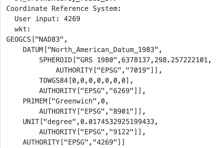
Absolutely, the fact that we have so many coordinate systems to deal with our dumb ellipsoidal earth means needing to understand incomprehensible incantations like what's listed below... just to load in data
Thankfully sf and terra have done a good job making the process very copy/pastable
Thankfully sf and terra have done a good job making the process very copy/pastable
November 8, 2025 at 2:09 AM
Absolutely, the fact that we have so many coordinate systems to deal with our dumb ellipsoidal earth means needing to understand incomprehensible incantations like what's listed below... just to load in data
Thankfully sf and terra have done a good job making the process very copy/pastable
Thankfully sf and terra have done a good job making the process very copy/pastable
Only takes a few lines of code to make a beautiful 3D plot in R!
----
library(rayshader)
montereybay |>
sphere_shade() |>
plot_3d(heightmap=montereybay,zscale=50, water=TRUE)
render_highquality()
(I'm cheating of course--the annoying part is loading the data into R!)
----
library(rayshader)
montereybay |>
sphere_shade() |>
plot_3d(heightmap=montereybay,zscale=50, water=TRUE)
render_highquality()
(I'm cheating of course--the annoying part is loading the data into R!)

November 8, 2025 at 1:58 AM
Only takes a few lines of code to make a beautiful 3D plot in R!
----
library(rayshader)
montereybay |>
sphere_shade() |>
plot_3d(heightmap=montereybay,zscale=50, water=TRUE)
render_highquality()
(I'm cheating of course--the annoying part is loading the data into R!)
----
library(rayshader)
montereybay |>
sphere_shade() |>
plot_3d(heightmap=montereybay,zscale=50, water=TRUE)
render_highquality()
(I'm cheating of course--the annoying part is loading the data into R!)
can't see how this could go wrong


November 8, 2025 at 1:37 AM
can't see how this could go wrong
A set of new render_highquality() options coming to a #rayrender near you 😀

November 8, 2025 at 1:17 AM
A set of new render_highquality() options coming to a #rayrender near you 😀